Maps API
Render addresses and coordinate results on customizable maps for dashboards, customer experiences, and internal tools with native support for broader routing workflows.
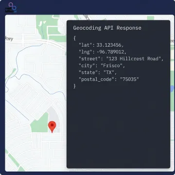
Turn raw latitude and longitude into accurate, readable addresses with a reverse geocoding API built for production use. NextBillion.ai helps product and engineering teams enrich coordinates with address context, support logistics workflows, and scale reliably with predictable pricing, fast integration, and enterprise-ready deployment options.
Coordinate-to-address tools and supporting location APIs for logistics, fleet, and mapping applications.
Render addresses and coordinate results on customizable maps for dashboards, customer experiences, and internal tools with native support for broader routing workflows.
Pair reverse geocoded addresses with turn-by-turn navigation so drivers, field teams, and applications can move from coordinates to actionable routes quickly.
Use resolved addresses and coordinates to calculate travel times, distances, and ETAs at scale for dispatch, assignment, and planning workflows.
Combine address conversion with virtual boundaries to trigger events, automate workflows, and monitor arrivals, departures, or dwell times in real time.
Transform live coordinate streams into understandable location context for tracking dashboards, customer updates, and operational visibility across moving assets.
Clean noisy GPS traces before downstream location analysis, helping coordinate-based workflows produce more reliable road-aligned positions and address context.
NextBillion.ai helps teams convert latitude and longitude into structured address data they can actually use in apps, dispatch systems, and analytics workflows. Beyond basic lookup, the platform fits enterprise needs with fast go-live support, predictable pricing alternatives to pay-per-call billing, cloud or on-premise deployment, and a broader location stack that connects address resolution with routing, tracking, and mapping.

See how teams use NextBillion.ai to power scalable, cost-efficient location workflows.
"By substantially reducing the number of developer hours spent on scheduling, NextBillion.ai's MVRP and large Distance Matrix API have helped us improve our operational efficiency and increase our cost savings significantly!"

"Support very good and friendly. Nextbillion provide the maps distance calculation with the low price but high value service to us. Nextbilions has help us reduce the cost and provide the same service as google!"
Built for teams that need more than a basic geocoding lookup.
Per-order and fixed-fee options help control costs as lookup volume grows.
Trial access starts quickly, with production go-live possible within about one week.
SOC 2, GDPR, CCPA, and ISO 27001 support enterprise procurement requirements.
Connect address conversion with routing, tracking, maps, and dispatch in one platform.
Experienced builders behind enterprise location infrastructure.

Co-Founder
Ajay Bulusu is a co-founder of NextBillion.ai, bringing deep expertise in geospatial technology and large-scale location platform engineering. His journey began in 2017 as part of Grab's pioneering Geo team, where he helped build the location infrastructure underpinning one of Southeast Asia's largest mobility and logistics platforms. That experience revealed how critical — and how underserved — accurate, flexible location technology was for real-world operations. Driven by a mission to democratize sophisticated location intelligence, Ajay co-launched NextBillion.ai in 2020. Under his technical leadership, the platform has scaled to serve 150+ businesses globally, optimize over 10.9 million deliveries and field tasks, and deliver more than $11 million in documented cost savings to customers.

Co-Founder
Gaurav Bubna drives product innovation at NextBillion.ai, bringing a proven track record of building successful products from scratch across ride-hailing, food delivery, and logistics. Before co-founding NextBillion.ai, Gaurav held product leadership roles at Grab, Ola, and Morgan Stanley — organizations where location technology and operational efficiency are existential. His time on Grab's Geo team alongside Ajay and Shaolin crystallized the vision: logistics and field service businesses needed enterprise-grade location intelligence without prohibitive per-call pricing. Since launching NextBillion.ai in 2020, Gaurav has led the product evolution that has helped the platform navigate over 557 million miles and raise $34.25M in venture capital from investors including Lightspeed and Microsoft's M12.

Co-Founder
Shaolin Zheng is a co-founder of NextBillion.ai, contributing deep technical expertise in geospatial systems and scalable mapping infrastructure. Like his co-founders, Shaolin's formative experience building location technology for Grab's Geo team gave him firsthand insight into the operational gaps that generic mapping solutions leave unaddressed — particularly for field service and logistics businesses operating at scale. His engineering perspective shapes NextBillion.ai's core philosophy: location technology must be customizable, cost-predictable, and production-reliable. The platform he helped build now powers GPS tracking, route optimization, and field service intelligence for over 150 businesses worldwide, with on-premise deployment options and SOC 2 Type II and ISO/IEC 27001:2013 certifications ensuring enterprise-grade security.
A reverse geocoding API converts geographic coordinates such as latitude and longitude into a human-readable address or place record. Developers use it to turn raw GPS points into structured location data like street, city, postal code, and country, making coordinates easier to display, search, analyze, and use in logistics, fleet, and customer-facing applications.
Talk with our team about your API, scale, and deployment needs.

Enterprise security controls independently validated.

Information security management standard certified.
Strong satisfaction across review platforms.
Share your reverse geocoding use case, expected volume, and deployment needs. We’ll help you evaluate fit, integration options, and the right pricing model.
To help us assist you faster, please include the reason for your message so the relevant team can reach out as soon as possible.
To help us assist you faster, please include the reason for your message so the relevant team can reach out as soon as possible.