Introduction
Delivery operations are under more pressure than ever. Tighter delivery windows, rising customer expectations for real-time visibility, and the compounding cost of failed attempts are squeezing margins where it matters most: the final mile.
According to Capgemini, last-mile delivery already accounts for 41% of total logistics supply chain costs. When deliveries fail, those costs compound fast. Most visibility gaps happen in this final leg — drivers go dark, customers have no idea when to expect them, and dispatchers can only react after problems surface.
Delivery platforms use geofencing to turn location events into automated triggers, rather than relying on drivers or dispatchers to report status manually. When a driver enters a delivery zone, leaves a depot, or lingers at a stop longer than expected, geofencing turns those location events into automated triggers — giving dispatchers the visibility to act before a late delivery becomes a failed one. That same trigger can update order status in the TMS and notify customers automatically, closing the visibility gap without adding steps to the driver's workflow.
This article covers what geofencing means specifically for delivery operations, the measurable benefits it delivers, real-world use cases, and the best practices that separate effective deployments from ones that stall after go-live.
Key Takeaways
- Geofencing creates virtual boundaries around delivery locations that trigger automated actions, requiring no manual driver input
- Key benefits: automated customer notifications, proof-of-location delivery validation, dwell monitoring, theft prevention, and richer analytics
- Polygon and isochrone boundaries outperform simple circular geofences for accuracy in urban last-mile work
- Geofencing delivers the best results when integrated with route optimization and your TMS, not deployed in isolation
- Privacy compliance requires transparent tracking policies, employee consent, and role-based data access
What Is Geofencing in Delivery Operations?
Geofencing is a virtual boundary drawn around a geographic location — a customer address, warehouse, depot, or delivery zone — using GPS, cellular, or Wi-Fi data. When a driver crosses that boundary, the system fires an automated action.
In a delivery context, those actions matter. When a driver enters a geofenced zone, the system can:
- Auto-log arrival time with a timestamp
- Send the customer a "your driver is nearby" notification
- Update order status in the TMS
- Alert the dispatcher that the stop is in progress
- Flag exceptions if the driver arrives significantly late
None of this requires the driver to tap anything. That's the operational point — removing manual steps from the most chaotic part of the route.
The Three Boundary Types That Matter
Not all geofences are built the same. Three boundary shapes are relevant to delivery operations:
| Type | How It Works | Best For |
|---|---|---|
| Circular | Fixed radius from a center point | Simple residential deliveries |
| Polygon | Custom shape tracing a building or zone footprint | Warehouses, commercial campuses, multi-unit buildings |
| Isochrone | Travel-time based (e.g., "5 minutes from customer") | Dynamic arrival alerts, proximity-based notifications |
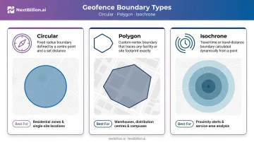
Circular geofences are easy to configure but imprecise. A 200-meter radius in a dense urban block triggers on drivers two streets over who never reached the drop-off.
Polygon and isochrone types solve that directly — one traces the actual facility footprint, the other maps real-world travel time. Both match actual geography instead of approximating it, which matters in last-mile work where false triggers create noise and erode data quality.
NextBillion.ai's Geofencing API supports all three types, plus corridors and custom shapes. Geofences can also be scheduled by time-of-day and day-of-week — useful for operations running tight delivery windows where boundary rules need to shift by shift or by route type.
Key Benefits of Geofencing for Delivery Operations
Automated Real-Time Customer Notifications
When a driver enters a geofenced zone around a customer address, the system fires an automatic notification — no dispatcher involvement, no driver action required. That "your driver is 10 minutes away" text goes out the moment the location event triggers.
Customers who know a driver is nearby are more likely to be available — and that availability directly cuts failed delivery attempts. Descartes reports the average failed delivery in the U.S. costs $17.20. With Urban Freight Lab research showing failed first-attempt rates exceeding 15% in U.S. cities, automated proximity alerts pay for themselves quickly.
Driver Accountability and Delivery Validation
Geofencing enforces proof-of-location delivery validation. A driver can only mark an order "delivered" when their device registers inside the correct geofenced zone. That closes the door on false delivery scans and the customer disputes that follow.
A 2024 HubBox survey of over 1,000 U.S. shoppers found that 15% of online orders were sent to the wrong address, and wrong house or block delivery was cited by 37% of respondents as a top pain point. A timestamped, location-verified delivery record doesn't just catch bad actors — it also protects drivers from false claims.
Reduced Idle Time and Dwell Monitoring
Geofence dwell data captures exactly how long a driver spends inside each stop zone. That surfaces inefficiencies that GPS breadcrumbs alone can't show:
- Excessive time at a stop due to access issues or customer delays
- Unauthorized idling between deliveries
- Prolonged depot turnarounds that push the rest of the route late
Operations managers can use dwell benchmarks to set service time targets for specific location types and flag outlier stops. A commercial delivery that consistently runs 30 minutes over benchmark isn't a driver problem — it's an access coordination problem that deserves a different fix.
Theft Prevention and Asset Security
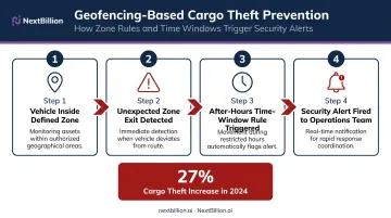
The same fleet visibility that catches dwell anomalies also flags security events. The National Insurance Crime Bureau reported that cargo theft incidents rose 27% in 2024, with a further 22% increase projected by end of 2025 — and the average single theft event valued at more than $202,000.
Geofencing adds a monitoring layer: when a vehicle exits a defined zone at an unexpected time, the system fires an alert. Combined with after-hours time-window rules — no movement expected between 10 PM and 6 AM, for example — teams can filter routine activity and surface genuine security events. NextBillion.ai's Geofencing API supports time-of-day and day-of-week scheduling precisely for this use case.
Richer Operational Analytics
Every geofence entry, exit, and dwell event generates timestamped data. Across hundreds of stops over weeks and months, that dataset becomes genuinely useful:
- Identify routes that consistently run late versus planned
- Compare dwell times across similar stop types to find outliers
- Build more accurate delivery time windows based on actual performance
- Spot depot departure patterns that compress the available delivery window
How Geofencing Improves Last-Mile Delivery Accuracy
Ensuring Drivers Arrive at the Correct Location
GPS is accurate to roughly 4.9 meters under open sky, but urban environments — buildings, bridges, reflected signals — degrade that meaningfully. In dense commercial areas or large campuses, a driver can appear to be "at" an address while standing on the wrong side of a building or at an adjacent loading dock.
Polygon geofences solve this. By tracing the actual footprint of a facility rather than drawing a circle around a street address, the system validates that the driver is at the right dock, entrance, or building — not just in the general vicinity. That precision prevents misdeliveries and eliminates the redelivery cycle that follows them.
Triggering Smart Dispatch and Dynamic Reassignment
When a driver exits a geofenced stop zone, that event can automatically queue the next job, notify the dispatcher, or trigger a workflow in the TMS. No check-in call required. Dispatchers get a live picture of which drivers have cleared which stops, enabling real-time rebalancing when a delay at one stop threatens the rest of the route.
Connecting Geofencing to Route Optimization
The optimized route defines the stop sequence; real-time geofence events confirm progress or flag deviations that need a response. Each layer does a distinct job — and the value compounds when they share data.
When a driver spends 40 minutes at a stop that should take 10, geofence dwell data surfaces that gap in the moment, not at end-of-day review. NextBillion.ai combines geofencing event data with AI-powered route optimization so that when a driver falls behind, the system automatically recalculates remaining stops to keep the rest of the sequence on time.
Geofencing Best Practices for Delivery Operations
Right-Size Your Geofence Boundaries
Oversized geofences generate premature triggers. A 500-meter radius for a home delivery will fire when the driver is still two blocks away, sending the customer notification too early and reducing its value. Undersized geofences cause missed events when normal GPS drift keeps the device just outside the boundary.
Calibrate boundary sizes by location type:
- Residential addresses: 50–100 meters for circular; polygon where building layout is distinct
- Commercial buildings: Polygon tracing the actual facility footprint
- Warehouses and distribution centers: Polygon with separate inner zones for dock areas
Use Polygon Shapes for Commercial and High-Density Locations
Replace circular geofences at warehouses, distribution centers, and multi-unit buildings with polygon geofences. Circular triggers at a large fulfillment center will fire for drivers passing on an adjacent highway. A polygon that traces the facility boundary ensures the trigger only fires when the driver is actually on-site.
Layer Geofences Across the Full Journey
Don't limit geofencing to the drop-off. End-to-end visibility requires boundaries at every meaningful stage:
- Depot departure — logs dispatch time, initiates customer notification sequence
- Midpoint checkpoints — progress monitoring on long routes
- Customer location — arrival validation, dwell monitoring, departure confirmation
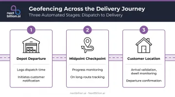
This layered approach replaces binary "delivered or not" tracking with a full timeline of dwell times, delays, and transitions at each stop.
Integrate Geofence Events with Your TMS and Notification Stack
Geofencing data is only as valuable as what you do with it. Event triggers should feed directly into your TMS, order management system, and customer-facing notifications — not sit in a silo.
When evaluating platforms, prioritize open APIs and pre-built integrations with existing fleet management tools. NextBillion.ai, for example, supports native bidirectional integrations with Geotab, Samsara, and Motive, so geofence events connect directly to dispatch and optimization workflows without manual handoffs.
Audit and Refine Geofence Parameters Regularly
Even well-configured geofences degrade over time. Businesses move, loading dock access changes, and delivery patterns shift — so treat geofence management as an ongoing operational process, not a one-time setup:
- Review false-positive zones quarterly
- Adjust boundaries at locations that consistently generate missed events
- Remove obsolete geofences for closed accounts or decommissioned facilities
Common Geofencing Use Cases in Delivery
Warehouse and depot departure triggers: A geofence around the hub fires when a driver leaves, logging dispatch time and initiating the customer notification sequence automatically. Drivers don't need to "start" a route — the system handles it the moment they cross the boundary.
Food delivery kitchen preparation: When a delivery driver enters a geofence around a restaurant, the kitchen receives an alert to begin preparing the order. This reduces driver wait time at pickup and keeps food temperature quality intact, a real advantage during lunch and dinner rushes when order volume spikes.
Multi-stop B2B route monitoring: For distributors making deliveries to commercial accounts — think a beverage distributor like AB InBev running dozens of retail stops per route — geofences at each stop validate service completion, log dwell time, and alert the route manager if a stop is skipped or a driver is running significantly behind.
CriticaLog, a premium logistics provider serving Fortune 500 healthcare clients, implemented NextBillion.ai's Geofencing API to automate dispatching based on geofence containment and trigger webhook notifications for vehicle entry and exit events, eliminating manual check-ins across their entire route sequence.
Choosing the Right Geofencing Solution for Your Delivery Business
Delivery operations need more than a basic geofencing tool. Evaluate platforms against these criteria:
- Triggering accuracy in urban environments — how does the platform handle GPS drift and multipath interference?
- Boundary type support — polygon and isochrone shapes are non-negotiable for high-density last-mile work
- Scale without per-event pricing penalties — a fleet running thousands of daily stops needs predictable costs
- Integration depth — does the platform connect natively to your TMS, fleet management tools, and customer notification stack?
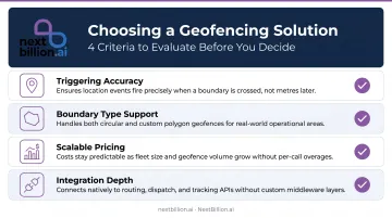
Standalone geofencing tools create integration overhead. Solutions that embed geofencing within a broader location intelligence stack — route optimization, live tracking, dispatch — eliminate the middleware complexity. NextBillion.ai's Geofencing API is built alongside its Route Optimization and Live Tracking APIs, with native integrations for Geotab, Samsara, and Motive, so delivery teams can connect location events directly to their dispatch and optimization workflows.
Privacy and Compliance Requirements
Delivery geofencing means tracking employees in the field — which carries legal obligations. California Penal Code Section 637.7 prohibits electronic location tracking without consent, with exceptions for vehicles where the registered owner or lessee has consented. CCPA also applies to employee data in California.
Any geofencing deployment should include:
- Transparent data-use policies communicated to drivers
- Documented consent processes before tracking begins
- Role-based data access controls limiting who can view location data
- Audit logging for compliance verification
NextBillion.ai is SOC 2 Type II, GDPR, and ISO/IEC 27001 certified, with Role-Based Access Control built into the platform.
Frequently Asked Questions
What is geofencing in logistics?
Geofencing in logistics uses GPS or cellular-based virtual boundaries around locations like warehouses, delivery zones, or customer addresses to automatically log asset movements, trigger notifications, and enforce delivery workflows. Everything happens without manual driver input when an asset crosses the boundary. Dispatchers rely on these boundary-crossing events to build a defensible audit trail for delivery timing, dwell duration, and compliance-related stops, without adding steps to the driver's workflow.
What are the benefits of geofencing for delivery operations?
Key benefits include automated customer notifications, proof-of-location delivery validation, dwell time monitoring for stop efficiency, theft prevention through zone-exit alerts, and event-level analytics that help managers optimize routes and time windows over time. Fleet managers also use geofence data to support FMCSA hours-of-service recordkeeping, since automatic arrival and departure timestamps reduce reliance on manual driver logs and cut disputes over stop duration.
How does geofencing improve last-mile delivery accuracy?
Geofencing validates that a driver is physically inside the correct delivery zone before allowing delivery completion. Polygon boundaries prevent misdeliveries at ambiguous addresses or large campuses, and every event generates a timestamped record that resolves "I never received it" disputes.
What types of geofences are used in delivery operations?
Three types cover most delivery use cases:
- Circular — simple radius boundaries suited for residential stops
- Polygon — traces actual building or facility footprints for accurate commercial locations
- Isochrone — uses real travel-time calculations to trigger events like "driver is 5 minutes away"
Most high-accuracy last-mile deployments rely on polygon or isochrone boundaries.
Can geofencing be used for both pickup and drop-off?
Yes. Geofences can be placed at origin points — restaurants, warehouses, depots — and destination points like customer addresses or commercial accounts. This gives operations teams end-to-end event tracking across the full delivery journey, not just confirmation at the final stop.
How does geofencing work with route optimization?
Geofence arrival and dwell events confirm real-time route progress against the planned sequence. When integrated with a route optimization engine, excessive dwell at a stop can trigger automatic recalculation of the remaining route, converting live location data into an immediate operational adjustment.
What is the purpose of a geofence in a delivery fleet?
A geofence's purpose is to turn a physical location into a trigger point for software actions. Instead of a dispatcher manually confirming a truck reached a depot or customer site, the boundary crossing itself fires the event: a notification, a status update, a dwell-time timer, or a zone-exit alert. This removes manual check-ins and gives operations teams a consistent, timestamped record of where and when assets moved.
Does geofencing help with delivery compliance and driver hours tracking?
Geofencing supports compliance indirectly. Automatic arrival and departure timestamps at customer sites, warehouses, or rest stops create a location-based record that can corroborate driver logs used for FMCSA hours-of-service tracking. It does not replace an ELD or HOS system, but the additional location data helps fleet managers verify stop durations and reduce disputes over recorded drive and rest time.