Introduction: Why Location Data Alone Isn't Enough for Enterprise Operations
Enterprise-grade geofencing and asset tracking vendors combine real-time location data with automated zone rules, turning raw GPS coordinates into arrival, departure, dwell, and theft alerts that operations teams can act on without manual monitoring. Most enterprise fleet operations already know where their assets are. The problem is that coordinates alone don't prevent a truck from sitting at a distribution center for three hours past its scheduled departure, and a dot on a map doesn't automatically alert anyone when a trailer leaves a yard at 2 AM.
U.S. business logistics costs totaled $2.3 trillion in 2024, equal to 8.7% of GDP. At that scale, the gap between seeing location data and acting on it is measured in real money — detention fees, missed SLAs, stolen equipment, and disputed invoices.
Geofencing closes that gap. It converts raw GPS coordinates into structured operational events: arrivals, departures, dwell violations, and after-hours alerts. This guide covers how enterprise geofencing works, which use cases generate measurable ROI, and what separates platforms built for operations from tools that just draw shapes on a map.
Key Takeaways
- Enterprise geofencing creates virtual boundaries that trigger automated alerts and workflow updates the moment an asset crosses them
- Asset tracking records where assets have been; geofencing tells you whether they should be there at all — turning location data into operational decisions
- Enterprise platforms require polygon geometry support, API-first zone management, and integration with TMS, WMS, and fleet systems
- Highest-ROI use cases: arrival/departure automation, after-hours theft detection, dwell-time SLA enforcement, and field service clock-in triggers
- Evaluate platforms on scalability, peak-event pricing, security certifications, and integration depth rather than map display quality
What Is Enterprise-Grade Geofencing (And Why Standard Tools Fall Short)
Geofencing creates a virtual boundary around a physical location using GPS, cellular, or RFID signals, then records or triggers actions when a tracked asset enters, exits, or lingers within it. This is the direct answer to whether geofencing tracks your location: it does not just track a position continuously, it evaluates that position against defined boundaries and generates an event only when something operationally relevant happens. Basic location tracking skips that evaluation entirely. It reports position — nothing more.
What "Enterprise-Grade" Actually Means
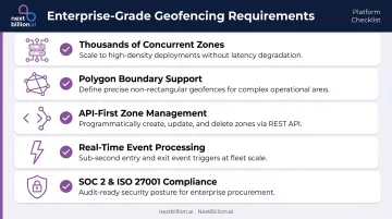
The distinction isn't about features on a marketing page. It's about operational scale and control. Enterprise-grade geofencing must:
- Manage thousands of concurrent zones without performance degradation
- Support polygon-shaped boundaries — not just circles — for irregularly shaped sites like port terminals, warehouse yards, or construction zones adjacent to public roads
- Expose complete zone management through APIs for programmatic creation and updates
- Process location events in real time, not batch jobs
- Meet security standards like SOC 2 Type II and ISO/IEC 27001
Consumer and SMB tools cap zone counts, restrict shapes to circles, and require manual dashboard management. That's workable for 10 delivery zones. It breaks down at 300.
The Relationship Between Geofencing and Asset Tracking
These two functions are complementary, not interchangeable. Asset tracking provides the continuous feed of location data: GPS pings from vehicles, trailers, OBD-II devices, or mobile apps. Geofencing is the context layer that defines what those locations actually mean.
Together they produce operational events with business context: "Truck 14 arrived at Distribution Center 3 at 2:47 AM — 18 minutes late." Without geofencing, that same data is just a coordinate and a timestamp.
How Geofencing and Asset Tracking Work Together at Scale
From Location Ping to Operational Event
The data flow is straightforward in concept, demanding in execution. Asset tracking hardware streams GPS coordinates continuously. The geofencing engine evaluates each coordinate against the library of defined zones and generates structured events — entry, exit, dwell threshold reached, violation.
At enterprise scale, this evaluation must happen in real time. Batch-processed overnight reports don't support same-day dispatch decisions or theft recovery.
Dwell time adds a critical second layer beyond simple entry/exit. Measuring how long an asset remains inside a zone enables:
- Warehouse utilization analysis (average unloading time per facility)
- SLA enforcement (flagging stops that exceed contracted time windows)
- Idle time detection for cost control
FMCSA data shows detention at approximately 1 in 10 trucking stops, with delays averaging 1.4 hours beyond a standard 2-hour loading window. A geofenced facility boundary turns that into a timestamped workflow — arrived, dwell threshold reached, escalated — while the truck is still on site.
That detention workflow is manageable for one stop. Multiply it across an entire fleet, and the complexity compounds fast.
Multi-Asset, Multi-Zone Complexity
Consider a mid-sized logistics operation: 500 vehicles, 2,000 trailers, 300 geofence zones covering distribution centers, customer sites, rest stops, and restricted areas. The event volume is substantial. This is the scale at which companies evaluating geofencing services need to look past basic mapping tools and toward vendors built for concurrent, multi-zone processing.
Enterprise platforms must handle this without degradation. That requires:
- Concurrent zone evaluation at scale
- Bulk zone creation via API (not manual entry per zone)
- Filtering and aggregation tools so operations teams see exceptions, not noise
- Clear alert routing so the right team gets the right signal
NextBillion.ai's Live Tracking API handles thousands of simultaneous asset locations across multiple fleets, deployable on AWS, Google Cloud, Azure, or on-premise within a private Kubernetes environment. Its Geofencing API supports polygons, circles, corridors, and custom shapes — the geometry range enterprise operations typically require.
Enterprise Use Cases That Drive Measurable ROI
Logistics and Last-Mile Delivery
Automated arrival confirmation is the most immediate win. Without geofencing, drivers manually log arrivals or dispatchers make confirmation calls. With geofencing, the platform records timestamp, dwell time, and departure automatically when the vehicle crosses the delivery zone boundary — no driver input required, no dispatcher call needed.
When a delivery vehicle enters a geofence zone near a customer's location, the system can also push an automated ETA notification. The operational benefit is documented: fewer inbound "where is my order" calls and accurate proof-of-service records that hold up in billing disputes.
Fleet and Asset Security
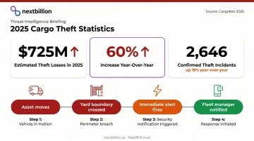
After-hours geofence violations are the clearest security application. When a vehicle or trailer moves outside a defined yard boundary during non-operational hours, an alert fires immediately to the fleet manager — with enough lead time to act before the asset is gone.
The threat is real and growing. CargoNet estimated 2025 cargo theft losses near $725 million, up 60% year-over-year, with confirmed theft incidents rising 18% to 2,646 events. Yard-exit alerts during off-hours provide deterrence and cut the response window significantly.
Compliance zone enforcement is the other security-adjacent use case:
- Keep vehicles within approved operating corridors
- Alert when a truck enters a restricted zone (low bridges, hazmat exclusion areas)
- Maintain auditable location history for regulatory reviews
Field Service Management
When a technician's vehicle enters a customer site geofence, several things can happen automatically:
- Job status updates to "in progress"
- Clock-in triggers in the time-tracking system
- Dispatcher receives notification of on-site arrival
When they exit, job completion is logged — no manual timesheet entry, no dispatcher follow-up call.
Samsara's FY2025 annual report cites geofencing and GPS data as the mechanism for automating time-on-site reports for accurate billing in equipment monitoring. Arrival and departure events create a verifiable, timestamped record that resolves billing disputes and validates SLA compliance.
What Enterprise Geofencing Platforms Must Include
Flexible Zone Geometry and Bulk Management
Polygon geofencing matters because real operational sites aren't circles. A port terminal, an irregularly shaped warehouse, or a construction site adjacent to a public road requires boundaries that match actual property lines. Circular zones in those environments generate false positives — alerts that fire because the zone shape doesn't match the site geometry.
Beyond shape flexibility, enterprise deployments need:
- Bulk zone creation via API — importing hundreds of zones from GIS data rather than drawing each one manually
- Time-of-day and day-of-week scheduling — geofences that activate only during operational hours, reducing noise
- Webhook support — so geofence events push into the enterprise's own systems in real time rather than requiring polling
NextBillion.ai's Geofencing API supports polygon, circle, corridor, and custom shapes, with time-of-day and day-of-week scheduling built in. Geofences feed directly into the routing engine as restricted zones, enabling dynamic route optimization that respects defined boundaries.
Performance, Reliability, and Security at Scale
Enterprise SLAs set the floor here. NextBillion.ai carries a 99.9% uptime SLA across its platform, with multi-region deployment across North America, Belgium, and Singapore.
A 99.9% annual availability target equals roughly 8 hours 45 minutes of allowable downtime per year. Anything below that threshold should come with service credits and incident documentation.
Location data security in enterprise operations carries real compliance and legal weight. Verify these requirements before committing to a platform:
| Requirement | What to Look For |
|---|---|
| Data encryption | In transit and at rest |
| Access controls | Role-based, with audit logging |
| Security certification | SOC 2 Type II |
| ISMS certification | ISO/IEC 27001 |
| Data residency | On-premise or private cloud option |
NextBillion.ai holds SOC 2 Type II and ISO/IEC 27001:2013 certifications across its full platform — including the Geofencing API — and supports on-premise deployment within a customer's own Kubernetes environment, cloud VPC, or private data center for organizations with strict data governance requirements.
Integration with Fleet and Operational Systems
Standalone geofencing creates operational silos. Geofence events need to feed into TMS, WMS, ERP, and fleet management systems — triggering downstream workflows, not sitting in a separate dashboard.
NextBillion.ai covers both sides of that integration requirement:
- Telematics — Samsara, Geotab, and Motive for bidirectional data flow, pulling vehicle and order data in while pushing optimized routes and geofence events back out
- Enterprise systems — Salesforce, SAP, and Microsoft Dynamics 365 for full workflow automation without custom development for most enterprise stacks
How to Evaluate and Deploy an Enterprise Geofencing Solution
Evaluation Criteria
| Criterion | What to Test |
|---|---|
| Scalability | Zone count limits, concurrent asset evaluation, event throughput at peak volume |
| Pricing model | Per-API-call vs. per-vehicle/per-asset — model cost at projected peak, not average |
| Integration depth | Native connectors vs. custom development for your TMS/WMS/fleet stack |
| Security posture | Current SOC 2 Type II report, ISO 27001 scope, incident history |
| Support model | Hands-on deployment support availability and response SLAs |
Per-call pricing deserves specific attention. AWS prices geofence operations by the number of evaluated device positions per month. At low volumes, that's manageable — but at enterprise scale, with thousands of assets generating millions of events daily, costs become unpredictable fast.
NextBillion.ai offers per-vehicle and fixed monthly pricing as a direct alternative, with fees that absorb volume fluctuations rather than spike with them.
Deployment Sequence
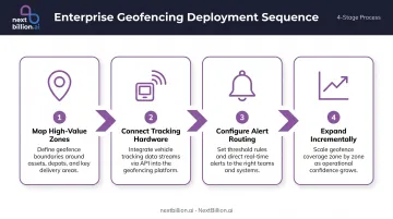
- Map high-value zones first — primary yards, major customer sites, high-risk corridors where blind spots are most expensive
- Connect to existing tracking hardware — integrate with current telematics (Samsara, Geotab, Motive) via API rather than replacing hardware
- Configure alert routing — match alert types to the right operational teams; after-hours alerts to security, dwell violations to dispatch
- Expand incrementally — add zones where operational blind spots still exist, using event data to prioritize
NextBillion.ai includes 24x7 solutions engineering support at no additional cost, with standard integrations reaching production go-live within about a week.
Key Failure Modes to Avoid
- Alert fatigue from too many low-value zones generating noise
- Default circular zones used in contexts where polygon precision is operationally required
- Per-call pricing that becomes cost-prohibitive as event volume grows
- Standalone deployment without integration into route optimization and dispatch systems
Frequently Asked Questions
What is the difference between basic geofencing and enterprise-grade geofencing?
Basic geofencing handles small numbers of zones with manual UI management and typically restricts shapes to circles. Enterprise-grade platforms support thousands of concurrent zones, programmatic API control, polygon geometries, high-availability SLAs, and native integration with fleet and logistics systems at scale.
How does geofencing improve asset tracking for large fleets?
Geofencing converts continuous location pings into structured operational events: arrivals, departures, dwell time, and violations. These events trigger automated workflows, SLA monitoring, and exception alerts — so dispatchers act on signals rather than comb through raw location history.
What types of assets can be tracked with enterprise geofencing?
Both powered assets (fleet vehicles, construction equipment) and non-powered assets (trailers, containers, bins, tools) can be tracked based on the hardware attached. Enterprise platforms must handle mixed-asset fleets with different device types and update frequencies within a unified geofencing engine. In the US, this often means reconciling GPS telematics on tractors with battery-powered trackers on trailers and yard equipment, each reporting on a different schedule, without losing a single operational view.
What security certifications should an enterprise geofencing platform have?
SOC 2 Type II and ISO/IEC 27001 are the standard enterprise benchmarks. Organizations with data residency requirements should additionally require on-premise or private cloud deployment options to prevent location data from leaving their controlled environment. US fleets handling driver location data should also confirm the vendor's approach to FLSA-related timekeeping records and, where health or hazmat cargo is involved, HIPAA or PHMSA-adjacent data handling practices during procurement review.
How does geofencing integrate with route optimization?
Geofence arrival and departure events can feed back into route optimization engines to update ETAs, trigger next-stop dispatch, and flag deviations from planned routes. NextBillion.ai's Geofencing API feeds directly into its Route Optimization API, supporting closed-loop workflows where real-world events update active plans in real time.
How is enterprise geofencing priced, and what should I watch out for?
Per-API-call pricing is affordable at low volumes but scales poorly — each ping evaluated against each zone is a billable call. Per-vehicle or fixed monthly models offer more predictability. Model costs at projected peak event volume, not average fleet size, before committing.
Which companies offer geofencing services for enterprise fleets?
The market splits into mapping/routing API providers (like NextBillion.ai) that offer geofencing as part of a broader location stack, standalone telematics and fleet management platforms with built-in geofencing modules, and legacy GPS tracking vendors that added geofencing as a feature. Enterprises should evaluate based on whether geofencing needs to integrate with routing, dispatch, and compliance workflows, or function as a standalone alerting tool.
Does geofencing track your exact location in real time?
Geofencing itself does not continuously track precise location — it evaluates incoming location pings (from GPS or telematics devices) against defined zone boundaries and fires an event only when a boundary is crossed or a dwell threshold is met. Continuous, real-time tracking is a separate capability. Enterprise platforms typically combine both: constant tracking feeds the geofence engine, which then filters that stream into actionable arrival, departure, and violation events.