The global geofencing market reached $1.95 billion in 2022 and is growing at 21.7% annually — driven largely by logistics, fleet management, and field service operations that need location-based automation, not just location visibility. With dozens of tools available, the choice comes down to your use case: developer API, fleet platform, or enterprise GIS system.
This guide covers the top 10 geofencing software tools, what each does well, and what it costs.
Key Takeaways
- Geofencing software creates virtual boundaries that trigger automated actions when assets cross them — alerts, workflow triggers, reports, and notifications.
- Developer APIs (Radar, NextBillion.ai, HERE) give engineering teams full control; fleet platforms (Samsara, Geotab, Verizon Connect) provide no-code dashboards for ops teams.
- Per-API-call pricing can escalate sharply at logistics scale; per-vehicle or per-order models keep costs predictable.
- Polygon geofences outperform circular ones for irregularly shaped sites like warehouses, port terminals, and job sites.
- Match your shortlist to your pricing model, accuracy requirements, and existing integrations — not just feature count.
What Is Geofencing Software?
Geofencing software uses GPS, Wi-Fi, cellular, or RFID signals to define virtual boundaries around real-world locations and trigger predefined actions when a tracked entity crosses them. Those actions can include alerts, webhook calls, workflow automations, proof-of-delivery logs, or customer notifications — all without manual intervention.
Geofencing software is a system that draws virtual boundaries around real-world locations and automatically triggers actions—alerts, webhook calls, workflow automations, proof-of-delivery logs, or customer notifications—when a tracked vehicle, device, or asset crosses those boundaries. It automates location-based workflows rather than just showing where something is on a map. There are two primary implementation paths:
- API/SDK-based geofencing — developer tools for embedding geofence logic into custom logistics, fleet, or delivery applications
- Platform-native geofencing — built into fleet management or field service dashboards, requiring no custom development
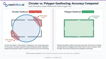
Shape matters more than most buyers expect. Circular geofences work fine for a single address, but GPS accuracy degrades near buildings and in dense urban environments — GPS.gov reports typical smartphone accuracy of 4.9 meters under open sky, with measurably worse performance in urban canyons.
Polygon geofences, which can follow the actual perimeter of a warehouse dock, port terminal, or irregular job site, eliminate the false entry/exit triggers that plague circular boundaries in tight operational environments.
Top 10 Geofencing Software Tools: Features & Pricing
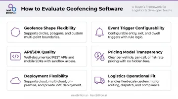
Tools were evaluated on six criteria: geofence shape flexibility, event trigger configurability, API/SDK quality, integration depth with fleet and logistics systems, pricing model transparency, and fit for operational scale.
1. NextBillion.ai
Built by the ex-Grab Geo team, NextBillion.ai is a logistics-first location intelligence platform with a geofencing API purpose-built for fleet and delivery operations at scale.
| Key Features | Polygon, circle, corridor, and custom shape geofences; time-of-day and day-of-week scheduling; real-time entry/exit alerts and automated actions; geofences feed directly into the routing engine as restricted zones; native integrations with Samsara, Geotab, and Motive |
| Best For | Last-mile delivery platforms, logistics ISVs, field service operations, enterprise fleets needing geofencing + route optimization in one stack |
| Pricing | Per-vehicle, per-order, or per-API-call pricing models; predictable fixed monthly fees; free trial API key available; custom enterprise pricing — contact for quote |
What sets it apart: CriticaLog, a logistics operator running 300–400 vehicles across multiple city hubs, implemented NextBillion.ai's geofencing with 2km radius zones around hubs and up to 5km around customer premises. The result: automated dispatching, webhook notifications for entry/exit events, and reduced app performance impact through static checks rather than continuous polling.
The corridor geofence type stands out specifically — designed for transportation routes rather than point locations, which most competitors don't offer natively. Geofences also integrate directly with NextBillion.ai's Route Optimization API, enabling proof-of-delivery confirmation, automated customer ETA notifications, and depot check-in logging as part of a single connected workflow.
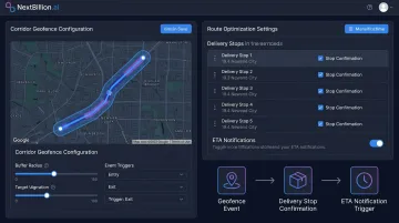
Deployment options include AWS, Google Cloud, Azure, and on-premise (Kubernetes, private VPC, or private data center). The platform is SOC 2 Type II, ISO/IEC 27001:2013, GDPR, and CCPA certified.
2. Radar.io
Radar is a developer-first geofencing and location infrastructure platform, positioning itself as "geofencing as infrastructure" for product and engineering teams.
| Key Features | Circle (10m–10,000m radius), polygon (4–2,000 coordinates in GeoJSON), and isochrone geofences; entry, exit, and dwell events with configurable thresholds; iOS, Android, and web SDKs; event webhooks; unlimited geofences documented |
| Best For | Engineering teams building custom location-aware apps, retail and delivery app developers |
| Pricing | Pricing not publicly listed — contact Radar for current plans |
Radar's geometry documentation is among the most explicit in the market — circle radius bounds and polygon coordinate limits are published in the developer docs. Dwell time thresholds and operating hours per geofence add operational flexibility beyond basic entry/exit.
3. Google Maps Platform
Google Maps Platform offers geofencing capabilities through its Geometry Library and Places API, widely adopted due to map data quality and developer familiarity.
| Key Features | Polygon and geometry calculations via Maps JavaScript API; Places API for location context; global map data coverage; Android Geofencing API for mobile apps |
| Best For | Web and mobile apps needing rich map context alongside basic geofencing |
| Pricing | Per-billable-event pricing by SKU, calculated monthly — costs scale with usage volume |
Google's Maps Platform does not provide a native fleet event-streaming geofencing system. The Geometry Library handles polygon calculations; the Android Geofencing API handles mobile transitions. Custom logic is required to bridge them into an operational event pipeline. At logistics scale — thousands of daily geofence events across a fleet — per-call billing can become the dominant cost driver.
4. HERE Technologies
HERE is an enterprise location platform serving automotive OEMs, logistics operators, and multinational fleets with carrier-grade reliability.
| Key Features | REST-based Geofencing API for asset-in-zone checks; polygon, polyline, and point boundary types; administrative boundary layers (country, postal code, census); isochrone logistics alerts (for example, 15-minute ETA warehouse pre-alerts); truck-attribute-aware routing data |
| Best For | Automotive OEMs, enterprise logistics, multinational fleet operators requiring global data coverage |
| Pricing | Asset-based licensing through a HERE account executive — enterprise/custom pricing |
HERE's documentation includes a concrete logistics use case: triggering a warehouse alert 15 minutes before a truck arrives, using isochrone polygons. Global coverage and European data depth make it a strong choice for cross-border freight operations.
5. Samsara
Samsara is a connected operations platform combining GPS tracking, dashcams, IoT sensors, and built-in geofencing — all manageable from a single dashboard without writing code.
| Key Features | Dashboard-based geofence creation (circular and polygon); configurable entry/exit alert webhooks with 5-retry exponential backoff; driver safety integrations; REST API and webhook access for developers |
| Best For | Mid-to-large fleet operators in trucking, construction, and field service |
| Pricing | Custom quote based on fleet size bucket (1–5, 6–29, 30–499, 500–4,999, 5,000+ assets) — contact Samsara for pricing |
Samsara's Address feature allows operators to define locations with configurable geofences and sync data via API — bridging no-code simplicity with developer extensibility. For fleets already using Samsara hardware, adding geofencing requires no additional infrastructure.
6. Geotab
Geotab is an open-platform fleet management system with geofencing built into its MyGeotab dashboard and extensible through an open SDK.
| Key Features | Zone creation (circular, square, polygon) in MyGeotab; exception reporting tied to zone events; rule-based alerts for fleet activity; JavaScript and C# SDK for custom development; marketplace add-ins |
| Best For | Enterprise and government fleets, telematics resellers building on an open platform |
| Pricing | Plan-based (Base, Regulatory, Pro, ProPlus, GO) — contact a reseller for per-vehicle pricing |
Geotab serves over 2,000 government customers on its public fleet platform, which reflects its strength in regulated, compliance-driven environments. Zone-based exception reporting — where alerts fire only when a rule is violated — keeps fleet managers focused on problems rather than raw data streams.
7. Verizon Connect
Verizon Connect is a fleet management and GPS tracking platform with geofencing as a standard feature inside its Reveal dashboard.
| Key Features | Geofence zone creation and configuration; automated arrival/departure alerts; fleet activity reports at monitored locations; near real-time visibility |
| Best For | Large enterprise fleets, organizations already in the Verizon ecosystem |
| Pricing | Custom quote — contact sales |
Verizon Connect's main differentiator is network reliability: connectivity backed by Verizon's infrastructure matters for fleets operating in areas where cellular coverage is uneven. Pricing transparency is limited, and it's generally better suited to larger enterprise deployments than small or mid-size operations.
8. AllGeo
AllGeo (by Abaqus) is a field workforce management platform designed for businesses managing field technicians, service crews, and mobile employees.
| Key Features | IFTTT-style rules engine for custom workflow triggers; geofence-based clock-in/out automation; mobile forms for field data collection; payroll system integrations; mileage tracking and EVV compliance modules |
| Best For | Field service companies, mobile workforce management, compliance-driven industries |
| Pricing | Custom pricing — contact AllGeo |
AllGeo's rules engine goes well beyond entry/exit: it can trigger overtime alerts, shift rule enforcement, and attendance policy automations based on geofence events. For businesses managing hourly field workers across multiple job sites, this depth of automation is difficult to replicate with a generic fleet tracking tool.
9. Foursquare (Places API / Movement SDK)
Foursquare's location technology platform offers geofencing and place-based detection backed by one of the largest independent POI datasets globally.
| Key Features | 100M+ verified POIs across 200+ countries with 50+ attributes; POI-based geofencing without manual coordinate entry; Movement SDK for location-based app development; audience analytics |
| Best For | Retail logistics, delivery arrival verification at named locations, location analytics teams |
| Pricing | Places API: free up to 10,000 calls/month (Pro endpoints); $15.00 CPM for 10,001–100,000 calls; Premium endpoints at $18.75 CPM for first 100,000 calls |
Foursquare's advantage is its POI database — you can trigger geofence logic at a named business location without manually entering coordinates. For delivery verification across hundreds of retail stops, that reduces setup time significantly.
The usage-based pricing model means costs scale with call volume, so high-frequency logistics apps should model total monthly calls before committing.
10. Esri ArcGIS
Esri ArcGIS is the enterprise GIS standard, with geofencing capabilities built into ArcGIS Velocity and GeoEvent Server for real-time and big-data spatial analysis.
| Key Features | Real-time and dynamic geofencing via ArcGIS Velocity; GeoEvent Server for importing and managing geofences from feature datasets; complex polygon support across large geographic areas; enterprise security and compliance certifications |
| Best For | Government agencies, utilities, and enterprises with existing GIS infrastructure |
| Pricing | Annual user-type licensing (Creator, Professional, Professional Plus, Mobile Worker, Contributor, Viewer); includes 250–500 credits per user type — contact Esri for volume pricing |
ArcGIS is a spatial intelligence platform — the complexity and cost are significant compared to purpose-built fleet solutions. That said, if your organization already runs ArcGIS for spatial data management, extending it to geofence monitoring is a natural fit.
How We Chose the Best Geofencing Software
Tools were assessed across six criteria:
- Geofence accuracy and shape flexibility — circular vs. polygon vs. corridor support
- Event trigger and alert configurability — entry, exit, dwell, time-based scheduling
- API/SDK quality and integration depth — documentation, webhook support, fleet system connectors
- Pricing model transparency and scalability — per-call vs. per-vehicle vs. per-order at operational volume
- Deployment flexibility — cloud, multi-cloud, or on-premise
- Fit for logistics and field operations — not just technical capability, but operational alignment
The most common buying mistake: choosing a tool based on map UI quality or brand name without testing the pricing model at production volume. A per-API-call model that costs next to nothing in a sandbox can turn into a serious cost exposure when processing thousands of geofence events daily across a real fleet. Calculate your monthly event volume before comparing plans.
The right choice depends on your context:
- Developer teams building custom apps → Radar, NextBillion.ai, HERE
- Fleet managers who need no-code zone management → Samsara, Geotab, Verizon Connect
- Field workforce and compliance operations → AllGeo
- Enterprise GIS environments → Esri ArcGIS
- POI-based logistics and retail → Foursquare
Conclusion
The best geofencing software isn't the one with the most features on paper. It's the one whose accuracy, pricing model, and integration depth match how your operations actually run — whether that's managing 50 vehicles with a dashboard or processing millions of geofence events daily across a delivery network.
Before committing to any platform, run two checks against your real operating conditions:
- Total cost of ownership: Calculate pricing at your actual event or vehicle volume, not just trial-tier rates — costs compound fast at scale.
- Geofence accuracy: Test against your specific site types. Circular geofences at a dock entrance behave very differently than polygon geofences mapped to a warehouse perimeter or irregular job site.
For logistics, delivery, and field service teams that need geofencing within a broader location intelligence stack — route optimization, real-time tracking, and fleet integrations included — NextBillion.ai offers a purpose-built platform with predictable per-vehicle or per-order pricing and hands-on engineering support. Request a demo or explore the API documentation to see how the platform handles your volume and site complexity.
Frequently Asked Questions
What is the difference between geofencing APIs and geofencing platforms?
Geofencing APIs are developer tools for embedding geofence logic into custom applications — they require engineering resources but offer full control over implementation. Geofencing platforms provide no-code dashboards for creating and managing zones without development work. Some tools, including NextBillion.ai, offer both, serving technical teams and operations managers within the same product.
How accurate is geofencing technology for fleet operations?
GPS-enabled devices are typically accurate to within 4.9 meters under open sky, but accuracy degrades near buildings, bridges, and in urban canyons due to signal reflection. Polygon geofences handle irregular-shaped sites — warehouses, port terminals, job sites — more precisely than circular ones, reducing false entry/exit triggers.
What industries benefit most from geofencing software?
Logistics and last-mile delivery, fleet management, field service, construction, retail, and healthcare all have strong use cases. Automated location-based event triggers reduce manual check-ins and improve visibility across any operation with mobile assets or distributed workforces. Fleet operators also use geofencing to support FMCSA hours-of-service and IFTA reporting by tying location events to duty status and jurisdiction crossings, cutting manual log entry.
How does geofencing integrate with route optimization software?
Geofence events — arrival, departure, dwell time — can confirm stops, update ETAs, trigger next-stop dispatch, and generate proof-of-delivery records. Platforms like NextBillion.ai combine both capabilities natively, so a geofence arrival event at a delivery address can automatically close the stop and recalculate the remaining route.
What should I look for in geofencing software pricing?
Per-API-call pricing can look affordable in testing but grows fast at production scale, where hundreds of vehicles generate multiple events per stop. Per-vehicle or per-order models offer more predictable costs. Calculate your total expected monthly event volume before comparing plans. Also check whether zone creation, editing, and dashboard seats are billed separately, since operations teams often need those beyond the core API.
Can geofencing software work offline or in low-connectivity environments?
Most API-based geofencing requires live connectivity to report events. Some mobile SDKs support on-device evaluation, queuing events locally and syncing once connectivity returns, which matters for construction sites and rural routes. Confirm offline handling with any vendor before deployment.
Can I do my own geofencing?
Yes, if you have engineering resources. Building geofencing in-house means writing point-in-polygon logic, handling GPS noise and false triggers, and maintaining zone data as sites change. Most teams find this eats development time better spent on core product work, which is why they use a geofencing API or platform instead of building detection logic from scratch.
Is geofencing API free?
Most production-grade geofencing APIs, including NextBillion.ai's, are not free for commercial use, though many vendors offer free tiers or trial credits for testing and evaluation. Free or open-source options exist but usually lack polygon support, high-volume event handling, or reliable uptime for production fleets. Confirm usage limits and event volume caps before committing to any free plan for live operations.