This isn't a standard software infrastructure question. The cost exposure from per-API-call pricing, latency requirements for real-time routing, data sovereignty regulations, and the sheer volume of spatial queries make deployment model selection genuinely complex. Get it wrong, and you're either paying runaway API bills at scale or running over-provisioned hardware for workloads that don't justify it.
This article breaks down both deployment models through the lens of geospatial analytics, covering the trade-offs that matter most for operations-heavy teams and a practical decision framework to help you choose.
Key Takeaways
- On-premises gives you full data control and predictable costs, but requires upfront hardware investment and in-house IT capacity
- Cloud offers faster setup and elastic scaling, though per-call pricing can spike unpredictably at high logistics query volumes
- The decision hinges on five factors: query volume and cost structure, real-time latency needs, regulatory compliance, IT team maturity, and long-term cost modeling
- High-frequency routing in regulated industries often favors on-premises or hybrid; fast-scaling or globally distributed platforms favor cloud deployment
- NextBillion.ai supports both deployment models, so you're not locked into an infrastructure choice before selecting your platform
On-Premises vs. Cloud for Geospatial Analytics: Quick Comparison
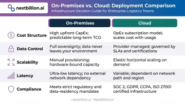
The table below summarizes how on-premises and cloud deployments compare across the five dimensions that matter most for geospatial analytics workloads.
| Dimension | On-Premises | Cloud |
|---|---|---|
| Cost structure | High upfront CapEx; predictable long-term costs with no per-query billing | Low initial cost; pay-as-you-go pricing can escalate significantly at high volumes |
| Data control | Full ownership and physical control of location data | Data resides with a third-party provider; shared responsibility model |
| Scalability | Requires hardware procurement; suited for stable, predictable workloads | Near-instant horizontal scaling; handles demand spikes well |
| Latency | Low-latency responses for co-located data and compute | Variable based on network conditions and region proximity |
| Compliance | Easier to demonstrate data residency and regulatory compliance | Achievable with careful provider vetting (SOC 2, ISO 27001, GDPR) |
What Is On-Premises Deployment for Geospatial Analytics?
With on-premises deployment, the organization installs and operates all mapping, routing, and spatial data processing software on its own servers — either in an internal data center or a dedicated private environment. Queries never leave the organization's network, and compute resources are dedicated rather than shared. On-premises is sometimes referred to as self-hosted or in-house deployment, terms used interchangeably to describe infrastructure that an organization owns and operates rather than accessing as a hosted service.
In practice, spatial databases (PostGIS), route optimization engines, and map tile servers all run on internal hardware. Open-source tools like OSRM, Valhalla, and PostGIS make self-hosted routing and spatial querying technically viable for teams that can manage the infrastructure and data pipelines.
Core Benefits for Logistics and Field Service Teams
- Replaces variable per-API-call billing with flat infrastructure costs — a significant advantage at high query volumes
- Low-latency responses — co-located compute and data cuts network round-trip time for real-time dispatch and routing
- Keeps location data air-gapped from external systems, satisfying strict internal privacy and data residency policies
- Allows direct editing of road network rules, custom speed profiles, and map attributes — no dependency on a provider's data layer
Infrastructure Requirements and Challenges
On-premises isn't without its demands. Teams need:
- Upfront server and software procurement costs
- Internal DevOps or IT capacity for deployment management, patching, and uptime
- Capacity planning responsibility — scaling up means physical hardware procurement
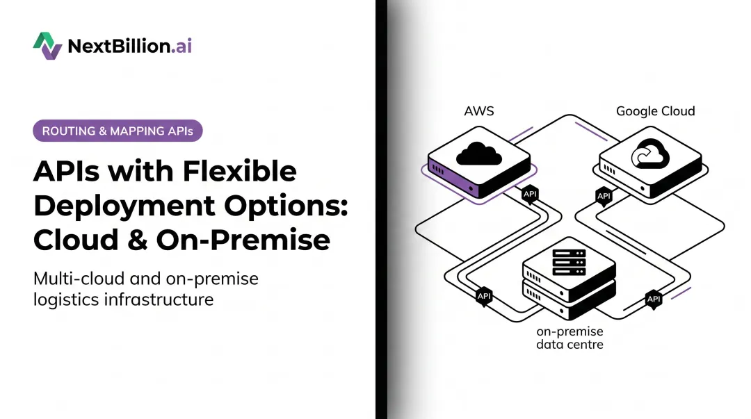
Kubernetes-based deployments have reduced this overhead considerably. NextBillion.ai's on-premises option, for example, deploys through Kubernetes clusters on AWS EKS, GCP GKE, Azure AKS, or bare-metal servers, using an open-source utility called k10s to simplify setup.
Helm chart templates and modular deployment let teams install only the APIs they need — Directions, Distance Matrix, Route Optimization — rather than the entire stack.
When On-Premises Is the Stronger Fit
These infrastructure trade-offs are worth it in specific scenarios:
- Regulated industries with strict data residency requirements (government logistics, healthcare transportation, defense-adjacent operations)
- Large-scale logistics operators with high, predictable query volumes where flat infrastructure costs beat per-query cloud pricing
- Organizations that need deep customization of road attributes or routing logic
- Logistics software companies embedding geospatial capabilities into their own products, where per-API-call pricing at scale would erode margins
For the last case — an ISV building route optimization into their platform — NextBillion.ai's on-premises deployment offers a fixed fee with unlimited API calls, which eliminates the per-call exposure that makes cloud APIs cost-prohibitive when embedded at scale.
What Is Cloud Deployment for Geospatial Analytics?
Cloud deployment means accessing mapping, routing, geocoding, and spatial processing capabilities through APIs hosted and maintained by a third-party provider. Providers like Google Maps Platform, HERE, and Mapbox charge based on usage volume — per API call, per element, per transaction, or via subscription tiers.
Google states that core service pricing is determined per billable event, calculated monthly. Mapbox structures pricing similarly, with free monthly tiers and automatic volume discounts at higher usage. Cloud geospatial services manage all infrastructure, map data updates, security patching, and scaling.
Core Benefits
- Fast time to production — no hardware procurement, no infrastructure setup
- Automatic map data updates — traffic layers, satellite imagery, and road network changes are managed by the provider
- Elastic scaling — handles demand spikes (peak delivery seasons, event-driven dispatch surges) without pre-provisioning
- Lower barrier to entry — accessible for teams without dedicated infrastructure staff
Key Challenges for Geospatial Workloads
Per-call pricing becomes a real problem at logistics scale. Route optimization, distance matrix calculations, and geocoding are each billed separately by most major providers. Google separates Single Vehicle Routing and Fleet Routing into distinct SKUs; Mapbox meters matrix calculations by origin-destination element, not by request. Thousands of route optimizations and millions of geocoding lookups per month add up quickly. This is why cloud is not automatically cheaper than on-premises: at low or unpredictable query volumes cloud's pay-as-you-go model wins on cost and speed to launch, but at sustained high volumes the flat infrastructure cost of on-premises can undercut per-call cloud billing over time.
Additional risks specific to geospatial workloads:
- Vendor lock-in — routing logic built tightly around provider-specific APIs is difficult to migrate
- Quota constraints — Google's Route Optimization API, for example, carries a default quota of 60 QPM for optimization calls, which can constrain high-throughput dispatch systems
- Latency variability — if the cloud region is distant from your operational geography, network round-trip time can affect real-time dispatch SLAs
Some of these risks can be mitigated architecturally. Serverless geospatial setups (AWS Lambda with Amazon Location Service, Aurora PostgreSQL with PostGIS) and cloud-agnostic platforms reduce vendor dependency — but the per-call billing exposure remains regardless of how you structure the infrastructure.
When Cloud Deployment Makes Sense
- Startups and fast-growing delivery platforms that need to launch quickly
- Companies with variable or geographically distributed demand (food delivery, ride-sharing)
- Teams where query volumes remain manageable on a consumption-based model
- Organizations that need continuously updated map data and traffic layers without managing their own data pipeline
A food delivery startup launching across multiple cities simultaneously is a clear fit — cloud APIs are running in days, not weeks, and consumption-based pricing is affordable while volumes are moderate. Once daily route optimization volumes climb into the hundreds of thousands, that per-call model starts working against them.
On-Premises vs. Cloud: Which Is the Right Fit for Your Geospatial Analytics?
The right model isn't universal. It depends on where your organization sits across four dimensions.
Cost at Scale
Cloud subscription pricing is efficient at low query volumes. At high, predictable volumes, on-premises fixed infrastructure typically delivers a lower per-query cost.
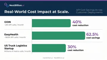
The math is workload-specific, but the direction is clear: per-call billing compounds. Routing, matrix, geocoding, and optimization are metered separately by most providers. Customer results from NextBillion.ai illustrate the gap:
- GOIN (~2M API calls/month) — 40% cost reduction after switching platforms
- EasyHealth (~900K calls/month) — 62.5% cost savings vs. their prior solution
- US truck logistics startup (millions of matrix calls/month) — 30% cost reduction after moving to asset-based pricing
For on-premises deployments, NextBillion.ai offers unlimited API calls at a fixed fee — a structure that removes per-call exposure entirely once deployed.
Latency and Real-Time Requirements
For use cases requiring sub-second routing responses — real-time driver dispatch, live ETAs, dynamic re-routing — on-premises or co-located infrastructure eliminates network round-trip time. Cloud handles batch operations and lower-frequency queries well, but latency variability is a real constraint for high-frequency real-time workloads.
NextBillion.ai's on-premises deployment is architected for this: Kubernetes Horizontal Pod Autoscaler (HPA) and multi-replica deployments maintain low-latency performance even during peak loads.
Data Sovereignty and Compliance
Three regulatory frameworks create clear on-premises pressure for specific industries:
- GDPR — EDPB Guidelines 01/2020 establish that connected-vehicle location data can constitute personal data under GDPR, requiring data minimization, legal basis, and processor due diligence
- HIPAA — NEMT platforms and healthcare logistics vendors working with covered entities must assess whether trip, rider, and location data constitutes PHI
- NIST SP 800-171 — published in 2024, this governs protection of Controlled Unclassified Information in nonfederal systems, directly affecting government and defense logistics contractors
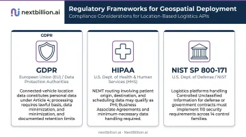
On-premises and private cloud deployments are generally easier to audit and certify under these frameworks. NextBillion.ai holds SOC 2 Type II, ISO/IEC 27001:2013, GDPR, and CCPA certifications — applicable across deployment models — with on-premises configurations keeping all routing queries, user data, and logs behind the customer's own firewall.
Situational Decision Guide
On-premises fits when:
- Query volumes are high and predictable
- Regulatory requirements mandate data residency or air-gapped environments
- You need deep map customization or custom road attribute control
- You're embedding geospatial into your own product (ISV/platform builder)
Cloud fits when:
- You need rapid deployment without infrastructure investment
- Query volumes are variable or in early growth stages
- You lack a dedicated infrastructure team
- Operations are globally distributed with fluctuating regional demand
Hybrid makes sense when:
- You want cloud for development and testing, on-premises for production
- You need burst capacity alongside a stable on-premises core
- Your compliance requirements apply only to production location data, not dev environments
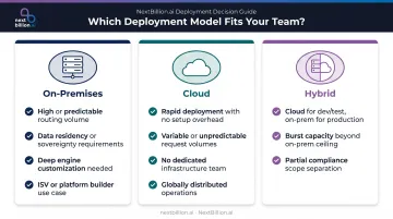
NextBillion.ai supports all three paths — cloud-based APIs, private cloud on your chosen provider, and Kubernetes-based on-premises deployment — so teams aren't locked into an infrastructure model before choosing a geospatial platform.
The modular architecture lets you start with cloud APIs and migrate on-premises as volumes grow, selecting only the routing modules you need rather than redeploying everything from scratch.
Conclusion
On-premises and cloud deployment both serve legitimate, distinct needs in geospatial analytics. Neither is universally better. The model that delivers the most value depends on where an organization sits in terms of scale, regulatory context, and operational maturity.
The stakes are concrete: deployment model directly affects route optimization speed, delivery cost predictability, and data security posture. A fleet operation paying per-call at millions of monthly queries faces different economics than a startup running a few thousand route requests a day. A NEMT provider handling patient transport data faces compliance constraints that a food delivery startup simply doesn't.
Those differences are what make deployment fit a decision that belongs alongside platform capability — not after it. Get the infrastructure right, and geospatial analytics scales with your operations. Get it wrong, and costs compound in ways that constrain what your team can actually do with the data.
Frequently Asked Questions
What is the difference between on-premises and cloud deployment for geospatial analytics solutions?
On-premises deployment runs all geospatial processing — routing, geocoding, spatial queries — on the organization's own servers, giving full data control and predictable costs. Cloud deployment accesses these capabilities via APIs managed by a third-party provider, offering faster setup and scalability but variable pricing that can escalate significantly at the query volumes common in logistics operations.
Is on-premises deployment becoming obsolete for geospatial analytics solutions?
No. For high-volume logistics and field service operations, on-premises often delivers lower per-query costs and more consistent latency than cloud alternatives. This matters for US fleets managing FMCSA hours-of-service compliance and dispatch windows, where dropped connectivity or lag can affect driver logs. Modern platforms increasingly support both deployment options, and many enterprises run hybrid configurations — using cloud for development and on-premises for production — to capture the benefits of each.
What are the main types of IT infrastructure for deploying geospatial analytics solutions?
The three main options are on-premises (organization-managed servers), cloud (third-party hosted services accessed via API), and hybrid (a combination of both). Enterprise platforms increasingly support all three through cloud-agnostic APIs and Kubernetes-based packaging, so organizations can shift models as needs change.
Which deployment model is better for real-time geospatial analytics?
On-premises or co-located infrastructure typically delivers lower and more consistent latency for real-time routing and dispatch, making it the preferred choice for high-frequency, sub-second geospatial workloads. Cloud deployment is suitable for batch processing or lower-frequency real-time needs where some network latency is acceptable.
How does data security compare between on-premises and cloud geospatial analytics deployment?
On-premises keeps all location data behind the organization's firewall, with direct control over every layer of security tooling. Cloud follows a shared responsibility model — the provider secures infrastructure, the customer secures data access. Both can meet enterprise-grade standards, but on-premises is easier to audit for industries under GDPR, HIPAA, or federal data handling requirements. For US healthcare logistics or government fleet operations, this audit trail simplifies internal compliance reviews without relying on a third party's controls documentation.
Can a geospatial analytics platform support both on-premises and cloud deployment?
Yes. Modern enterprise platforms support both through Kubernetes-based on-premises packaging and cloud-hosted APIs on a single API surface. NextBillion.ai, for example, offers multi-tenant cloud, private cloud, and fully on-premises deployment — organizations can switch models without rebuilding their geospatial integration logic.
Is cloud cheaper than on-premises for geospatial analytics?
Not always. Cloud deployment lowers upfront costs and setup time, which suits smaller query volumes or pilot projects. But at the query volumes typical of US logistics and delivery fleets, per-call cloud pricing can exceed the fixed cost of on-premises infrastructure over time. The cheaper option depends on query volume, latency needs, and whether an organization already has servers and IT staff to manage on-premises systems.
What is another name for on-premises deployment?
On-premises deployment is also called "on-prem," "in-house," or "self-hosted" deployment. All three terms describe running geospatial analytics software on infrastructure the organization owns or directly controls, rather than accessing it through a third-party cloud provider's servers. Some enterprise documentation also refers to this as "customer-managed" or "private" infrastructure, distinct from public cloud or SaaS delivery models.