Introduction
In November 2024, three men died in Bareilly, Uttar Pradesh after their car plunged off an unfinished bridge while following Google Maps directions. BBC reported that the bridge section had collapsed in floods months earlier — yet the app showed it as a live route. A month later, six people were injured in Hathras when Google Maps guided two cars onto an under-construction highway.
These aren't isolated glitches. They point to a structural gap — Google Maps was not built with India's infrastructure complexity as a primary concern. That gap has commercial consequences, too.
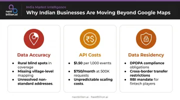
Indian users and businesses are turning to homegrown alternatives to Google Maps for three reasons: local data accuracy gaps, high API costs at scale, and data residency concerns. Each pressure is distinct:
- Data accuracy — outdated rural road data, missing village-level coverage, no standardized address resolution
- API costs — at $1.50 per 1,000 events for Directions API (India pricing), costs scale steeply for high-volume logistics operations
- Data residency — user location data routed to US servers, raising concerns under India's Digital Personal Data Protection Act
Together, these gaps explain why homegrown options like Mappls have gained ground with Indian developers and enterprises.
What follows is a practical evaluation of the top homegrown and India-relevant navigation options — assessed across consumer use, developer APIs, and enterprise logistics needs.
Key Takeaways
- Mappls by MapMyIndia is the strongest Indian-built option : 30 years of local map data, an ISRO partnership, and 95% of India's in-dash OEM navigation market
- Ola Maps offers aggressive developer pricing but carries platform risk due to an ongoing legal dispute with MapMyIndia
- ISRO Bhuvan and NavIC are sovereign infrastructure layers, not consumer navigation apps
- Waze serves urban Indian commuters well despite being Google-owned
- For logistics and fleet operations, consumer apps aren't designed for commercial scale — platforms like NextBillion.ai address routing constraints, predictable pricing, and data residency in a single stack
Why Indian Businesses Are Looking Beyond Google Maps
The Accuracy Problem
Google Maps crowdsources much of its road data globally, which works well in densely connected urban areas but creates blind spots across India's rural and semi-urban regions. Village-level address coverage is inconsistent. Non-standardized Indian addresses — which make up a significant portion of last-mile delivery destinations — often fail to resolve accurately.
The Bareilly and Hathras incidents illustrate the worst-case outcome. But for businesses, the day-to-day version is quieter: drivers making wrong turns, ETAs that don't account for real road conditions, delivery failures in areas with no reliable address pin.
The Cost Dimension
Google's India-specific pricing reduction (effective August 2024) brought Directions API costs down to $1.50 per 1,000 events — roughly 70% below the global rate. That's genuinely helpful for small developers. For a logistics company processing 500,000 routing requests monthly, however, that's still $750/month on directions alone, before distance matrix and geocoding calls.
Indian media reported Google cut these prices specifically in response to Ola Maps' free-tier launch — suggesting the competitive pressure was real.
The Data Residency Question
India's Digital Personal Data Protection Act (DPDPA) introduces specific obligations that matter for location-data users:
- Location data falls under DPDPA when it identifies a specific individual
- The Act permits the government to restrict cross-border data transfers to notified countries
- For fintech and regulated industries, RBI already mandates that payment system data be stored only in India
All three of these pressures — accuracy gaps, API costs, and data residency rules — have pushed Indian businesses to evaluate alternatives. Since 2020, homegrown options have developed to the point where that evaluation is worth making.
Top Indian Alternatives to Google Maps
Evaluation criteria: Indian road accuracy (rural and village-level coverage), India-specific feature depth, developer API availability and pricing, data residency practices, and suitability for consumer or enterprise use.
Mappls by MapMyIndia
Background: CE Info Systems was incorporated on February 17, 1995, a full decade before Google Maps launched in February 2005. The consumer app Mappls and the developer API platform are products of that history — backed by a publicly listed company (NSE: MAPMYINDIA) and a 2021 MoU with ISRO covering NavIC positioning and satellite imagery from Bhuvan, VEDAS, and MOSDAC.
MapMyIndia claims 95% of India's in-dash navigation market for passenger vehicles — a figure from their own automotive page and difficult to independently verify, but consistent with their OEM partner depth.
Key differentiators:
- Mappls Pin converts any location into a 6-character code, addressing India's non-standardized address problem — over 2 crore pins available across urban and rural properties
- Live traffic signal countdown launched in Bengaluru (October 2025), the first Indian city with this feature
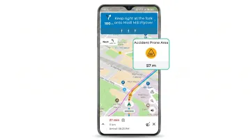
- Hazard alerts for potholes, speed breakers, and waterlogging
- 3D junction views, toll cost calculator, multimodal transit routing
- Offline navigation available via NaviMaps
| Details | |
|---|---|
| Key Features | Voice-guided navigation, 3D junction views, traffic signal timers, hazard alerts, toll calculator, multimodal routing, Mappls Pin, offline maps, ISRO/NavIC integration |
| Best For | Individual drivers on Indian highways and rural roads; developers needing India-first map APIs with data on Indian servers |
| Pricing | Free consumer app; API pricing contact-based (official page says "Start for free") |
Ola Maps
Background: Launched in July 2024 as part of Ola Krutrim's AI platform, Ola Maps is primarily a developer API product built on routing data from Ola's ride-hailing network.
One caveat worth noting upfront: MapMyIndia sent Ola a legal notice in 2024 alleging that Ola Electric copied and reverse-engineered MapMyIndia data in violation of a 2021 agreement. The legal status remains active — a meaningful platform risk for any business building a core product on it.
Key differentiators:
- At launch (July 2024), Ola claimed 5 million free API calls/month and paid pricing at 50% of Google's reduced India rates
- The current pricing page states 500,000 complimentary API requests/month — cite the 5M figure as a launch-period offer, not current policy
- Directions, Autocomplete, Geocoding, Reverse Geocoding, and Map Tiles APIs all available
- Indian data residency
| Details | |
|---|---|
| Key Features | Directions API, Autocomplete, Geocoding, Map Tiles; built on Ola ride data; Indian data residency |
| Best For | Cost-conscious Indian startups needing high free-tier API volume; not recommended as a primary consumer navigation app |
| Pricing | 500,000 free API requests/month (current); paid tiers claimed at 50% of Google's India rates at launch |
ISRO Bhuvan and NavIC
Background: These are not navigation apps. They are India's sovereign geospatial infrastructure. Bhuvan is ISRO's satellite imagery and thematic mapping portal. NavIC (Navigation with Indian Constellation) is India's regional satellite system — a 7-satellite constellation covering India and up to 1,500 km beyond its boundary, with designed positioning accuracy better than 20 meters.
As of a December 2025 Parliament answer, the government had not yet formally mandated NavIC in smartphones, though the BIS standard IS 19321:2025 exists. Apps like Mappls integrate NavIC through the ISRO MoU.
Bhuvan's recent applications include Bharat Darshan (covering 42 UNESCO-protected locations) and Kasturi (20 cultural heritage landscapes), launched in early 2026.
| Details | |
|---|---|
| Key Features | Satellite imagery portal (Bhuvan); India-specific satellite positioning (NavIC); thematic and heritage mapping; government data ownership |
| Best For | Government agencies, researchers, and app developers building on Indian geospatial infrastructure |
| Pricing | Bhuvan free for eligible use cases; NavIC is a system-level feature, not a paid service |
Waze
Background: Waze has been Google-owned since June 2013 (acquired for $966M). It belongs in this comparison because its community-driven traffic model genuinely works on Indian roads — not because it's Indian-built. With roughly 180 million monthly active users globally, it has an active Indian urban user base.
Key differentiators:
- Crowdsourced real-time alerts for traffic, police presence, accidents, and road hazards
- Automatic mid-trip rerouting to avoid delays
- Minimal interface built for speed
Limitations: No offline maps, limited rural India coverage, no developer API for Indian market applications, data on US servers.
| Details | |
|---|---|
| Key Features | Crowdsourced traffic and hazard alerts, automatic rerouting, police alerts, simple UI |
| Best For | Urban Indian commuters prioritizing fastest route; not suitable for rural navigation or API use |
| Pricing | Free consumer app; no general-purpose developer API for India |
NextBillion.ai
Background: NextBillion.ai is an enterprise location technology platform built by the team behind Grab's geospatial infrastructure — the same engineers who designed routing for one of Southeast Asia's largest mobility platforms. The company serves logistics, delivery, fleet management, and field service operations in India and globally. Indian customers include Zepto, Meesho, and Gojek.
Consumer apps solve individual navigation. A delivery fleet has a different problem: sequencing 200 stops across 30 vehicles while respecting time windows, load limits, driver shift caps, and vehicle type restrictions — recalculating in real time when conditions change. That's what NextBillion.ai is built for.
Key differentiators:
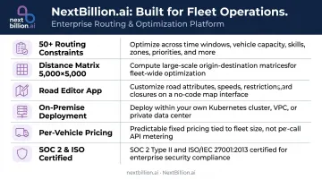
- 50+ hard and soft routing constraints — time windows, vehicle load limits, driver working hours, skills-based assignment, multi-dimensional capacity
- Distance matrix up to 5,000×5,000 elements (versus Google's 25×25 limit), supporting up to 25 million pairs in a single call
- Road Editor App — a no-code tool for adding custom road attributes: closures, turn restrictions, custom speed limits, no-entry zones, plying permissions — all feeding directly into routing and navigation APIs with no lag
- On-premise deployment within a customer's own Kubernetes environment, cloud VPC (AWS, GCP, Azure), or private data center — supporting Indian data residency requirements
- Per-vehicle or per-order pricing instead of per-API-call billing — fixed monthly costs that absorb demand spikes without unpredictable invoices
- SOC 2 Type II and ISO/IEC 27001:2022 certified
| Details | |
|---|---|
| Key Features | Route optimization with 50+ constraints, distance matrix API (5000×5000), GPS tracking, custom road editing, fleet dispatching, on-premise deployment |
| Best For | Logistics companies, last-mile delivery platforms, fleet operators, and field service businesses needing enterprise-grade routing APIs |
| Pricing | Fixed monthly pricing per vehicle or per order; contact NextBillion.ai for enterprise pricing |
Conclusion
The Indian navigation landscape has real options now — though each serves a different purpose.
Mappls is the strongest India-built choice for consumers and developers who need India-first map data, village-level address coverage, and local feature depth. Ola Maps is worth watching for cost-sensitive API users, but the MapMyIndia legal dispute is a real vendor risk for any business depending on API continuity. ISRO Bhuvan and NavIC underpin India's geospatial sovereignty without replacing any consumer or enterprise tool. Waze remains useful for urban commuters, Google ownership aside.
That distinction matters differently once you move from a single driver to a fleet. Consumer apps solve the "how do I get there" problem. Enterprise operations need route sequencing, constraint handling, custom map editing for local road conditions, and pricing that doesn't scale exponentially with API call volume.
If your operation runs deliveries, fleets, or field service in India and needs more than turn-by-turn navigation, explore how NextBillion.ai's enterprise routing and mapping APIs handle India-scale operations — with on-premise deployment options, predictable per-vehicle pricing, 50+ optimization constraints, and custom road-attribute control built for logistics complexity.
Frequently Asked Questions
What are the best Indian alternatives to Google Maps?
Mappls by MapMyIndia is the leading homegrown option, with 30 years of Indian map data, village-level coverage, and an ISRO partnership. Ola Maps offers competitive API pricing for developers. The right choice depends on your use case: consumer navigation app, developer API, or enterprise routing platform — each is a fundamentally different tool.
Is Mappls better than Google Maps for Indian roads?
Mappls has stronger coverage in rural India, village-level address data via Mappls Pin, and India-specific features like pothole alerts and traffic signal countdowns. Google Maps still leads in urban areas due to its larger crowdsourced user base for business listings and real-time traffic density.
Is Ola Maps safe for businesses to build on?
Ola Maps offers attractive pricing, but MapMyIndia's ongoing lawsuit alleging data copying creates legal uncertainty. For any business building a core product on Ola Maps, that dispute represents a real platform risk. Before committing engineering time to any map API, US-based teams should also weigh contract terms, data residency requirements, and how easily routes and geocoding can be migrated if a legal or pricing dispute forces a switch later.
Does India have its own GPS satellite system?
Yes. NavIC (Navigation with Indian Constellation) is ISRO's regional satellite navigation system, covering India and up to 1,500 km beyond its borders with positioning accuracy better than 20 meters. As of December 2025, no smartphone mandate had been formally enacted, though Mappls already integrates NavIC through its ISRO-MapMyIndia partnership.
Which Indian navigation app works best offline?
Mappls offers offline navigation capability through its NaviMaps product, making it the strongest choice when connectivity is unreliable. Waze requires a live data connection and offers no offline mode. Ola Maps currently does not support offline navigation.
Which navigation API is best for logistics and delivery businesses in India?
Consumer apps aren't built for fleet operations. Platforms like NextBillion.ai are purpose-built for logistics, with 50+ routing constraints, on-premise deployment for data residency, and per-vehicle pricing that stays predictable as call volumes grow — unlike the per-API-call billing that escalates with scale. This matters most for dispatch teams juggling FMCSA hours-of-service limits, driver breaks, and multi-stop routing, where a consumer maps app simply has no way to encode those constraints into a route.
What is the Indian version of Google Maps?
Mappls, built by MapMyIndia, is generally considered the closest Indian equivalent to Google Maps. It runs on its own map data rather than licensing Google's, includes India-specific features like village-level addressing and traffic signal countdowns, and integrates with ISRO's NavIC satellite system. For US teams evaluating global mapping vendors, it's a useful reference point for how regional map providers differentiate from Google.
Is NavIC better than Google Maps?
They aren't directly comparable. NavIC is a satellite positioning system, similar in role to GPS, that provides location signals. Google Maps is a mapping and navigation application that consumes positioning data from GPS or NavIC and layers on roads, traffic, and routing. NavIC can improve positioning accuracy on supported devices, but it doesn't replace the mapping, search, or routing functions that make Google Maps useful.