Introduction
Geofencing product services for logistics turn GPS, RFID, and cellular location data into automated alerts that fire the moment a truck, trailer, or driver crosses a defined boundary — replacing manual check-ins with real-time visibility. Picture this: an inbound truck arrives at your distribution center, but the receiving dock is unstaffed and the forklift operator is on break. Meanwhile, a driver takes an unauthorized detour — and nobody notices for three hours. A customer calls asking where their delivery is, and your dispatcher has to manually radio the driver to find out.
These aren't edge cases. ATRI research found that truck drivers were detained at 39.3% of stops in 2023, costing the industry $3.6B in direct expenses and $11.5B in lost productivity — much of it driven by poor arrival coordination and manual location tracking.
Geofencing addresses these gaps directly. By creating virtual boundaries around real-world locations, it turns passive location data into automated operational triggers — alerting dock staff before a truck arrives, flagging route deviations in real time, and giving dispatchers accurate ETAs without a single manual check-in.
This guide walks through what geofencing is, how it works technically, the core logistics use cases, key benefits and tradeoffs, and how to evaluate and implement a solution.
Key Takeaways
- Geofencing creates virtual geographic boundaries that trigger automated alerts when a vehicle or asset crosses them
- Core technologies include GPS, RFID, Wi-Fi, and cellular data — no specialized hardware beyond a standard tracker is needed
- Key logistics use cases: fleet route compliance, dock coordination, last-mile delivery notifications, asset security, and yard management
- Key benefits include real-time visibility, automated workflows, reduced dwell time, and improved on-time delivery rates
- Successful implementation depends on choosing the right geofence type, TMS integration, and well-defined alert workflows
What Is Geofencing in Logistics?
Geofencing is a location-based technology that establishes a virtual boundary — called a geofence — around a real-world geographic area using GPS, RFID, Wi-Fi, or cellular data. When a tracked device crosses that boundary, the system automatically triggers a pre-configured action: an alert, a status update, a notification to a customer, or a workflow in a connected platform. In trucking specifically, this same mechanism is applied to tractors, trailers, and yard assets — geofencing in trucking typically supports route compliance, dock scheduling, and detention tracking tied to hours-of-service and dwell-time visibility.
Google defines geofencing as defining perimeters around areas of interest and acting when a device enters or leaves. In logistics, that boundary crossing isn't just a notification — it's an operational input that drives decisions in real time.
Why Logistics Is Different
In retail or smart-home applications, geofencing is primarily a notification tool. In logistics, it's an operational input. The moment a geofence fires, it can:
- Update a shipment ETA in your TMS
- Notify a warehouse team to stage for an incoming truck
- Confirm proof of delivery without a driver manually scanning a barcode
- Alert a security team that a trailer has left a restricted yard zone
Location data stops being a supplementary insight and becomes a direct trigger for operational decisions.
Geofence Geometry: Circular vs. Polygon
There are two fundamental shapes, and the difference matters more than most buyers expect:
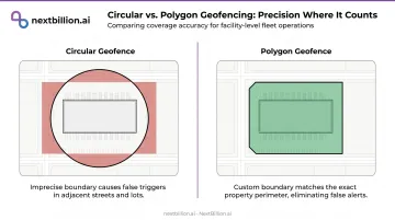
- Circular geofences define a radius around a single GPS coordinate — simple to configure, but imprecise at facilities with irregular layouts
- Polygon geofences trace a custom boundary that follows the actual perimeter of a facility, dock, or yard
For a standard delivery address, a circle works fine. For a port terminal, a distribution center with multiple loading bays, or a drop yard with a specific authorized parking zone, polygon geofences reduce false triggers significantly. Amazon Location Service's API supports both Circle and Polygon geometry. NextBillion.ai's Geofencing API goes further, supporting polygons, circles, corridors, and custom shapes to match complex operational footprints.
How Geofencing Works in Logistics
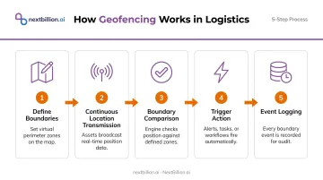
The technical flow has five steps:
- Define boundaries: An administrator draws the geofence in a software platform using mapping coordinates
- Continuous location transmission: GPS trackers, RFID tags, or mobile devices on vehicles and assets send position data in real time
- Boundary comparison: The geofencing software compares each location ping against defined boundaries
- Trigger action: When a boundary crossing is detected, the system fires a pre-configured response (email, SMS, webhook, or system status update)
- Event logging: All entries, exits, and timestamps are stored for reporting and performance analysis
Positioning Technologies and Their Tradeoffs
No single technology fits every logistics environment. Modern platforms layer multiple methods for redundancy:
| Technology | Accuracy | Best For |
|---|---|---|
| GPS (outdoors) | ~4.9 m under open sky | Vehicle arrival, yard entry, route-zone alerts |
| RFID | 7 cm to 100 m depending on frequency | Asset presence at gates, docks, pallets |
| Wi-Fi (802.11az) | Sub-0.1 m indoors | Indoor facilities, covered docks |
| Cellular | ~600 m | Fallback only in GPS-limited environments |
GPS.gov confirms that GPS accuracy degrades near buildings, bridges, and trees — a real consideration for urban delivery stops and covered loading bays. For those environments, RFID or Wi-Fi positioning is more reliable.
Geofence Types Used in Logistics
Static geofences are fixed around permanent locations — warehouses, distribution centers, customer addresses. These are the most common type and feed dock scheduling, ETA updates, and delivery confirmation workflows.
Dynamic geofences move or adapt based on real-time conditions. A practical example: a geofence that shrinks as a delivery vehicle approaches a customer's address, triggering an "arriving now" notification at a precisely calibrated moment.
NextBillion.ai's Geofencing API extends this further with isochrones and isodistances — boundaries defined by travel time or distance rather than fixed coordinates — for proximity-based driver dispatch. It also supports time-of-day and day-of-week scheduling, so boundaries stay active only during operating hours or specific delivery windows. This prevents off-hours false alerts and supports compliance monitoring for urban delivery zone restrictions.
Key Use Cases of Geofencing in Logistics
Fleet Route Compliance and Unauthorized Deviation
Fleet managers define geofences along approved corridors and around prohibited zones. Any vehicle crossing outside an approved route or entering a restricted area triggers an immediate alert — dispatchers can intervene in real time rather than reviewing driver logs the next morning. A common example: a geofence drawn around a customer's receiving yard that fires the moment a trailer enters or exits, giving dispatch a verified timestamp instead of relying on a driver's radio call.
Beyond incident response, this creates a compliance audit trail: timestamped entry/exit events that document route adherence for regulatory reporting or customer SLA verification.
Automated Dock and Warehouse Coordination
This is where the detention cost data becomes directly relevant. With $3.6B in direct detention expenses in 2023, even marginal improvements in arrival coordination have material financial impact.
A geofence around a warehouse's outer perimeter (set 10–15 minutes out from the dock) automatically notifies receiving staff, staging crews, and forklift operators when an inbound truck crosses it. By the time the truck reaches the bay, personnel and equipment are already in position.
Polygon geofences are especially valuable here. A circular boundary around a large distribution center may trigger on trucks parked on the adjacent street. A polygon that mirrors the actual facility perimeter fires only when the truck is genuinely on-site.
Last-Mile Delivery Accuracy and Customer Communication
McKinsey research shows that delivery speed has dropped to fifth priority for US consumers — but on-time reliability and scheduling flexibility have moved up. Over 50% of US consumers now prioritize delivery scheduling.
Geofences around customer delivery addresses enable automated "out for delivery" and "arriving now" notifications triggered by the driver's GPS position with no manual dispatch call required. NextBillion.ai's Geofencing API supports exactly this workflow, triggering automated customer ETA notifications and proof-of-delivery confirmation when assets cross defined boundaries.
When paired with route optimization, the system closes the loop: if a driver deviates from the optimal route, geofence event data can feed a recalculation, keeping ETAs accurate.
Asset Security and Theft Prevention
CargoNet reported 925 cargo theft events in Q1 2024 — a 46% year-over-year increase with quarterly losses of $154.6M. Verisk CargoNet estimates 2025 losses will reach nearly $725M. The scale of exposure makes real-time boundary monitoring a necessity, not a nice-to-have.
RFID-based geofences inside yards track individual tagged assets : trailers, containers, and high-value equipment. If an asset exits a designated safe zone without authorization, the system fires an alert immediately. For fleets managing trailers at drop yards overnight, this is the difference between catching an unauthorized move in minutes versus discovering it missing the next morning.
Yard Management and Scheduling Automation
Geofencing enables inbound trucks to be tracked automatically as they enter yard boundaries, feeding scheduling systems that assign dock slots and guide drivers to the correct bay. The result: less yard congestion, fewer trucks idling in staging lanes, and faster gate-in to dock-ready cycle times.
At a distribution center processing 300+ truck movements daily, that cycle-time reduction compounds fast — manual gate check-ins simply can't keep pace.
Benefits and Challenges of Geofencing in Logistics
Key Operational Benefits
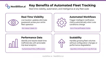
- Real-time visibility across the full asset fleet without manual check-ins or driver callbacks
- Automated workflows that remove human error from notification chains — arrival confirmation, customer alerts, and dock staging happen automatically
- Performance data — entry/exit timestamps and dwell records surface inefficiencies (excessive stop durations, route deviation patterns) that manual tracking misses entirely
- Scalability — once geofences are configured, they operate continuously regardless of fleet size
Implementation Challenges
GPS accuracy degrades near buildings and bridges — that 4.9-meter open-sky precision doesn't hold indoors or in dense urban canyons. For dock-door-level precision or covered loading bay detection, GPS alone isn't sufficient — RFID or Wi-Fi positioning is needed.
Alert fatigue is a real operational hazard. CCJ Digital has reported that false telematics alerts erode driver trust and push operators to disconnect or bypass tracking devices. The fix: tune thresholds so alerts fire only on meaningful events, not every micro-boundary crossing.
Privacy compliance requires deliberate attention. Under CCPA, precise geolocation data — defined as location within a 1,850-foot radius — is classified as sensitive personal information. California requires notice and proportionality for collection. Connecticut mandates prior written notice for electronic monitoring. Delaware has similar employee notification requirements. For platforms handling this data, CCPA compliance requires built-in controls for data minimization — NextBillion.ai's Geofencing API supports configurable data collection to limit personal data exposure to what operations actually require.
A geofence event that sends an email nobody acts on delivers zero operational value. The Descartes 2025 survey found only 17% of logistics operators are fully automated — geofencing only creates real operational value when events connect to dispatch systems, TMS platforms, or yard scheduling tools.
How to Choose and Implement a Geofencing Solution for Logistics
Evaluation Criteria
When assessing platforms, prioritize:
- Native TMS/fleet integration — does it connect to Samsara, Geotab, Motive, or your existing dispatch platform?
- Shape support — does it offer polygon geofencing, not just circles?
- Alert configurability — can you set dwell time thresholds, not just binary entry/exit triggers?
- Pricing predictability — per-vehicle or per-order pricing is more manageable than per-API-call models that spike with fleet activity
- Deployment flexibility — for operators with data-residency requirements, on-premise deployment matters
NextBillion.ai's Geofencing API addresses each criterion directly. It supports polygon, circular, corridor, and custom shapes; integrates with Geotab, Samsara, Salesforce, and SAP; and offers per-vehicle and per-order pricing as alternatives to pay-per-call billing. For teams with data-residency requirements, it deploys on-premise within a customer's own Kubernetes environment or cloud VPC, with SOC 2 Type II and ISO/IEC 27001:2013 certification.
Implementation Steps
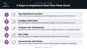
- Map operational locations — define geofence boundaries for all warehouses, customer addresses, restricted zones, and fuel stops
- Configure alert rules — assign recipients by role (dispatcher receives route deviation alerts; warehouse manager receives inbound truck alerts; customer receives ETA notifications)
- Integrate with dispatch or TMS — ensure geofence events trigger actionable workflows, not standalone email notifications
- Run a pilot — validate accuracy on a subset of routes before full rollout; refine polygon boundaries where false triggers occur
- Communicate with drivers — address privacy concerns proactively with clear written notice, particularly in California, Connecticut, and Delaware
Common Pitfalls to Avoid
- Define a workflow response for every geofence — unmapped alerts create noise that dispatchers will learn to ignore
- Use polygon shapes for complex facilities, not circles; a polygon matched to your actual perimeter eliminates most false triggers
- Archive entry/exit timestamps and dwell times — that event data is your benchmarking baseline for future improvements
- Audit and update boundaries when facility layouts change; stale geofences erode dispatcher trust faster than no geofencing at all
The Route Optimization Pairing
Once your geofences are running cleanly, integrating them with route optimization is where the real operational leverage appears. Geofencing captures where vehicles are relative to defined boundaries; route optimization determines the most efficient path between those boundaries. When connected, a geofence event — an early departure, an unauthorized stop, a delayed arrival — can automatically trigger a route recalculation, keeping downstream ETAs accurate without dispatcher intervention.
CriticaLog, a premium logistics provider serving Fortune 500 companies, implemented NextBillion.ai's Geofencing API with a 2-kilometer radius around hubs and up to 5 kilometers around customer premises. The result: automated dispatching and task assignment triggered by geofence containment, with static boundary checks replacing continuous polling — reducing app overhead while keeping location responses accurate.
Frequently Asked Questions
What is geofencing in logistics?
Geofencing is a location-based technology that uses GPS, RFID, Wi-Fi, or cellular data to create virtual boundaries around geographic areas. In logistics, when a vehicle or asset crosses those boundaries, automated alerts and workflows trigger — covering everything from dock arrival notifications to proof-of-delivery confirmation, without manual intervention.
How much does geofencing cost for logistics?
Cost varies by model. Many fleet telematics platforms include basic geofencing in their subscription. Standalone APIs or advanced platforms with polygon support are typically priced per device, per geofence, or on flat monthly tiers. Look for per-vehicle pricing over per-API-call models since per-call billing scales unpredictably as fleet activity increases. Also check whether polygon geofences, unlimited geofence counts, and webhook events cost extra, since these add up fast for multi-site operations.
Is geofencing legal in the US?
Yes, geofencing is legal for fleet and logistics operations. Employee tracking does require compliance with state privacy laws — CCPA classifies precise geolocation within 1,850 feet as sensitive personal information, and several states (including Connecticut and Delaware) require prior written notice for electronic monitoring. Maintain clear written policies and store location data securely.
What is the difference between static and dynamic geofencing in logistics?
Static geofences are fixed around permanent locations (warehouses, delivery addresses) and trigger events on entry or exit. Dynamic geofences shift based on real-time position, making them useful for proximity-based "delivery imminent" alerts or on-the-fly driver dispatch matching. Most logistics operations run both: static fences for yard, dock, and customer-site events, and dynamic fences layered on top for ETA-based alerts and last-mile handoff triggers as a vehicle approaches a moving target or unmapped stop.
How does geofencing integrate with route optimization software?
Geofencing captures asset position relative to defined boundaries; route optimization calculates the most efficient path between stops. When integrated, geofence events (an early arrival, a deviation, an unexpected stop) can automatically trigger route recalculations, keeping ETAs accurate and enabling dynamic dispatching decisions without manual dispatcher involvement.
What is geofencing in trucking?
In trucking, geofencing marks virtual boundaries around yards, docks, customer sites, or restricted zones so dispatch and compliance systems know when a truck enters or exits without a driver logging it manually. It supports automated check-in/check-out, detention time tracking, unauthorized-route alerts, and can feed data used alongside FMCSA hours-of-service records for audit trails and dispute resolution.
What is an example of geofencing?
A common example: a distribution center draws a geofence around its loading dock. When a delivery truck crosses into that boundary, the system automatically logs arrival time, notifies the receiving team, and starts a detention-time clock. When the truck exits, it triggers a departure timestamp and can prompt a proof-of-delivery or route-recalculation event for the next stop.