But cracks have appeared. In December 2022, Google folded Waze's 500-person team into its Geo organization — the same group that runs Maps, Earth, and Street View. Waze stayed a standalone app, but its independence became questionable. Add in a driver-only routing model with no offline maps, persistent data privacy concerns, and a UI cluttered with ads, and it's clear why millions of drivers are actively shopping for alternatives in 2026.
This guide cuts through the noise: five strong alternatives evaluated on real-time traffic, offline capability, privacy, multi-modal routing, platform support, and commercial suitability — so you can pick the right tool for how you actually drive.
Key Takeaways
- HERE WeGo is the closest like-for-like Waze replacement — offline maps, clean interface, multi-modal routing, free.
- Google Maps leads on coverage, POI data, and multi-stop routing; Apple Maps is the smartest default for iPhone users who care about privacy.
- OsmAnd and Organic Maps are the best picks for offline use and data privacy.
- Sygic is the strongest option for commercial and truck drivers needing vehicle-specific routing.
- Consumer navigation apps — Waze included — can't handle fleet routing at scale; businesses managing deliveries or field service need a dedicated platform like NextBillion.ai.
Why Drivers Are Reconsidering Waze in 2026
Waze's appeal was always its community. Tens of millions of drivers reporting police positions, potholes, accidents, and lane closures in real time gave it a genuine edge that was difficult to match at scale when Google acquired it in 2013 for $1.1 billion.
Since then, a different set of concerns has grown — centered on its limitations, shifting development priorities, and the direction the product is heading:
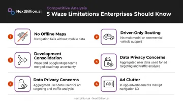
- No offline maps. Waze requires an active data connection — a meaningful limitation in rural stretches of the US Mountain West, national parks, and other low-coverage areas, as well as abroad.
- Driver-only routing. No walking, cycling, or public transit options.
- Development consolidation. With Waze's engineering team now embedded in Google Geo, the app's long-term differentiation from Google Maps is genuinely uncertain.
- Data privacy. A 2025 study published in Frontiers in Computer Science found that only 21.1% of users were aware that navigation apps collect real-time location data — and Google Maps (and by extension Waze) collects location, interests, and habits across its ecosystem.
- Ad clutter and UI distractions. The cartoon-heavy interface and in-navigation ads frustrate users who want clean, focused guidance.
None of this makes Waze unusable. For crowdsourced incident reporting, it still leads. What's changed is that competing apps have closed the gap on traffic intelligence while adding features — offline maps, multimodal routing, privacy controls — that Waze has never offered. The rest of this guide covers where each alternative actually pulls ahead.
Best Navigation Apps & Alternatives to Waze in 2026
Apps below were evaluated on: real-time traffic quality, offline map availability, platform support (Android, iOS, CarPlay, Android Auto), privacy practices, multi-modal routing, usability, and commercial suitability.
Google Maps
Google Maps hit 2 billion monthly users in late 2024 — the most widely used navigation app on the planet by a considerable margin. Its strengths are hard to argue with.
What it does well:
- Real-time traffic with alternate route suggestions
- Multi-stop routing (up to 9 stops)
- Offline map downloads for areas you define
- Full multi-modal support: driving, walking, cycling, public transit
- Live speedometer, Street View, satellite and terrain overlays
- Deep Android Auto and CarPlay integration
The tradeoffs are equally clear. Google's privacy policy explicitly covers location data collection tied to its broader advertising and services ecosystem — the same Frontiers study noted that Google Maps gathers location, date, time, and device data that can be shared across Google services. For users comfortable with that exchange, it's the most feature-complete option available, and its dense coverage of US road networks, business listings, and transit schedules is hard for smaller providers to match. For those who aren't comfortable with the privacy tradeoff, that's a real reason to consider the alternatives below.
| Feature | Detail |
|---|---|
| Real-time traffic | ✅ |
| Offline maps | ✅ (limited in some regions) |
| Multi-modal routing | ✅ Driving, walking, cycling, transit |
| Android Auto / CarPlay | ✅ |
| Platform | Android, iOS, Web |
| Pricing | Free |
Apple Maps
Apple Maps had a famously rough 2012 launch — Tim Cook later called it his "first really big mistake" as CEO. The current version is a substantially different product.
Offline maps arrived with iOS 17. Multi-stop routing now supports up to 14 stops. And Apple's privacy position is explicit: usage data is tied to rotating identifiers, not your Apple Account, and is not used for ad targeting.
Where Apple Maps stands out:
- No ad tracking — location data is genuinely separated from your identity
- Battery-efficient on iPhone hardware
- Deep Siri and CarPlay integration
- Flyover 3D mode covers 350+ cities
- Clean, uncluttered interface
Limitations:
- Coverage is uneven outside major markets — Apple's data covers approximately 35 countries (strong in North America and Europe, thinner elsewhere), per independent tracker Justin O'Beirne
- iOS/macOS only; Android users need not apply
| Feature | Detail |
|---|---|
| Real-time traffic | ✅ |
| Offline maps | ✅ (iOS 17+) |
| Multi-modal routing | ✅ Driving, walking, transit (cycling varies by region) |
| CarPlay | ✅ |
| Platform | iOS, macOS only |
| Pricing | Free (bundled with Apple devices) |
HERE WeGo
HERE WeGo is one of the strongest Waze alternatives, and it's consistently overlooked.
Backed by a consortium of major automakers including BMW, Audi, and Daimler, HERE Technologies is one of the world's largest mapping data providers. It supplies map data to automotive OEMs and enterprise logistics platforms globally. HERE WeGo is that same infrastructure delivered as a free consumer app.
What makes it the closest Waze replacement:
- Full offline maps — download by region, country, or continent
- Multi-modal routing: driving, cycling, walking, public transit
- Real-time traffic with user-controlled tracking opt-out
- Clean, ad-free interface
- "Leave at" / "arrive by" scheduling
- Android Auto and CarPlay support
The one meaningful gap: HERE WeGo lacks Waze's crowd-sourced incident reporting. You won't get real-time police alerts or user-reported road hazards at the same density. For traffic intelligence specifically, Waze still edges it out. For everything else — offline capability, routing versatility, privacy — HERE WeGo is a genuine upgrade.
| Feature | Detail |
|---|---|
| Offline maps | ✅ Country/continent-level |
| Real-time traffic | ✅ |
| Multi-modal routing | ✅ Driving, cycling, walking, transit |
| Android Auto / CarPlay | ✅ |
| Platform | Android, iOS, Web |
| Pricing | Free |
OsmAnd
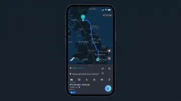
OsmAnd is built on OpenStreetMap — the volunteer-maintained, community-contributed map dataset covering roads, trails, waterways, and terrain worldwide. It's the choice for users who want full offline functionality and genuine transparency in how their data is handled.
Best for:
- Travelers in areas with poor or expensive mobile data
- Cyclists and hikers needing trail-level detail with elevation data
- Privacy-conscious users who want zero behavioral advertising
- Open-source advocates who want to inspect the code
The tradeoffs are real. OsmAnd's settings are deep and the learning curve is steeper than any other app on this list. The voice guidance sounds noticeably robotic. And the free tier starts with only 7 map downloads — you'll need the paid version for unlimited access.
| Feature | Detail |
|---|---|
| Offline maps | ✅ Full offline, any region |
| Data foundation | OpenStreetMap (community-maintained) |
| Routing modes | Driving, cycling, hiking, walking |
| Behavioral advertising | ❌ None |
| Platform | Android, iOS |
| Pricing | Free (7 downloads); paid for unlimited |
Sygic GPS Navigation
Sygic is the only consumer-facing navigation app on this list with explicit truck routing built in — and that distinction matters for commercial drivers operating under US size and weight restrictions, where state DOT rules on bridge clearances, axle weight limits, and hazmat routing vary by jurisdiction.
Through its truck profile configuration, Sygic lets drivers set vehicle-specific restrictions before a route is calculated: maximum weight, height, width, number of axles, cargo type, and hazmat classification. Routes generated through those profiles avoid roads where the vehicle isn't legally permitted to travel. No other app in this list calculates routes around those restrictions before departure.
Additional features worth noting:
- Full country-level offline maps
- Speed camera alerts
- 3D and satellite map views
- CarPlay support
- Dash cam mode (integrated within the app)
The catch: most advanced features, including truck routing, sit behind a paid subscription after a 7-day free trial. Professional drivers will find the cost straightforward to justify. Casual users likely won't.
| Feature | Detail |
|---|---|
| Truck routing | ✅ Weight, height, hazmat, axle count |
| Offline maps | ✅ Country-level |
| Speed cameras | ✅ |
| CarPlay | ✅ |
| Platform | Android, iOS |
| Pricing | Free trial (7 days); subscription for premium |
How We Chose These Waze Alternatives
The evaluation framework covered:
- Real-time traffic data quality and source (crowd-sourced vs. provider)
- Offline map availability and reliability
- Platform support: Android, iOS, CarPlay, Android Auto
- Privacy practices and data handling transparency
- Routing modes beyond driving (multi-modal breadth)
- Interface usability for everyday drivers
- Suitability for commercial and fleet use
- Relevance to US driving conditions, including interstate coverage, state-level trucking restrictions, and rural connectivity gaps cases
The mistake most people make when switching is defaulting to the most familiar name — usually Google Maps — without asking whether it actually fits their needs. A driver covering offline rural routes needs something different than a city commuter. Someone with privacy concerns probably shouldn't be using an ad-ecosystem-funded app by default, regardless of how popular it is.
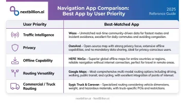
No single app wins on every dimension.
| Priority | Best Choice |
|---|---|
| Traffic intelligence | Google Maps, Waze |
| Privacy | Apple Maps, OsmAnd |
| Offline capability | OsmAnd, HERE WeGo |
| Routing versatility | HERE WeGo, Google Maps |
| Commercial/truck routing | Sygic |
When Consumer Navigation Apps Aren't Enough: Route Optimization for Fleets and Delivery Teams
Every app covered in this guide is designed for one driver making one trip. That's what they're built for. But it creates a hard ceiling for any business trying to use them for fleet operations.
The Gap Consumer Apps Can't Close
Consider what a delivery operation actually needs:
- Multi-stop sequencing optimized across dozens of vehicles at once
- Delivery time windows with per-stop service time factored in
- Vehicle-type constraints: weight limits, height clearances, hazmat routing
- Dynamic re-optimization when a driver breaks down, an order cancels, or a new job lands mid-route
- Hours of Service compliance for commercial drivers
Waze, Google Maps, Apple Maps — none of them touch any of this. A dispatcher manually building routes in a consumer app and texting stops to drivers isn't running an optimized operation; they're working around the tool's limitations.
McKinsey has documented that inefficient mid- and last-mile logistics handovers account for 13–19% of logistics costs — up to $95 billion globally. That's not a problem a navigation app solves.
What Enterprise Route Optimization Actually Looks Like
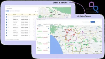
Operations that consumer apps can't serve need a different category of tool. NextBillion.ai is built for exactly that. The platform handles:
- Optimizes routes against 50+ hard and soft constraints — time windows, vehicle capacity, driver skills, depot preferences, hazmat rules, and HOS compliance
- Routes trucks via API and no-code Route Planner App using actual vehicle dimensions, weight limits, and cargo type
- Computes distance matrices at 5,000×5,000 scale, compared to the 25×25 limit in standard consumer map APIs
- Re-optimizes in real time when new orders arrive, cancellations come in, traffic shifts, or a vehicle breaks down
- Syncs natively with Samsara, Geotab, Motive, and Netradyne for two-way data flow between routing and fleet tracking
Pricing is structured as per-vehicle or per-order fixed monthly fees — not per-API-call, which becomes cost-prohibitive at fleet scale. Customers have documented 30–60% reductions in mapping API costs after switching from per-call pricing models.
The platform has optimized over 10.9 million deliveries across 150+ businesses globally, with $11 million in documented customer cost savings. It's SOC 2 Type II, ISO 27001, GDPR, and CCPA certified — relevant for enterprise buyers in healthcare, government, and financial services where data handling is non-negotiable.
For logistics and field service operations running more than a handful of vehicles, consumer navigation apps aren't the wrong choice — they're simply the wrong category of tool.
Conclusion
Waze is still a capable app in 2026 — particularly for drivers who rely on real-time incident reporting and don't need offline maps or multi-modal routing. But the alternatives are better matched to specific use cases than they've ever been.
Quick summary:
- HERE WeGo for clean, offline-capable everyday navigation across platforms
- Apple Maps for iPhone users who prioritize privacy and ecosystem integration
- Google Maps when coverage and POI depth matter most
- OsmAnd for offline-first, privacy-first use
- Sygic if you're a commercial or truck driver who needs vehicle-specific routing built in
For individual drivers: trial two or three of these apps against your actual routes before committing. Real-world performance — on your roads, at your usual hours — will tell you more than any feature comparison.
For logistics and fleet operators: if you're routing multiple drivers with consumer navigation apps, you're leaving route planning gaps that add up per driver, per day. Explore NextBillion.ai's route optimization platform to see what enterprise-grade routing looks like for your specific operation — the demo takes 30 minutes and includes a live walkthrough with a solution engineer.
Frequently Asked Questions
Is there a better alternative to Waze?
Yes. HERE WeGo is widely considered the closest functional replacement for everyday drivers, offering offline maps and multi-modal routing Waze lacks. Google Maps offers broader coverage and POI data, while OsmAnd leads for privacy and offline use. For businesses running deliveries or field teams, none of these consumer apps handle multi-stop planning, vehicle constraints, or route optimization at scale — that requires a dedicated routing API like NextBillion.ai.
Is Waze still good in 2026?
Waze remains strong for crowdsourced real-time traffic alerts, speed trap reporting, and incident flagging — that community-driven data advantage is real. However, the merger of its development team into Google Geo, missing offline maps, driver-only routing, and data privacy concerns have pushed many users toward alternatives.
What is the best free navigation app besides Waze?
HERE WeGo and Google Maps are the strongest free alternatives with full feature sets. OsmAnd is the best free option for offline maps and privacy — though the free tier limits you to 7 map downloads. Apple Maps is free but only available on Apple devices.
Which navigation app works best offline without data?
OsmAnd and HERE WeGo are the top offline-capable options, both supporting country-level map downloads before you lose connectivity — Sygic does too, but requires a paid subscription. Waze has no offline mode.
Which navigation app is best for truck drivers or commercial fleets?
Sygic is the strongest consumer app for truck-specific routing, supporting weight, height, axle count, and hazmat restrictions in its vehicle profile. For businesses managing multiple vehicles or complex multi-stop routes, a dedicated platform like NextBillion.ai is necessary — consumer apps don't handle fleet-scale routing constraints, hours-of-service planning, or the multi-vehicle dispatch logic that FMCSA-regulated carriers and delivery operations depend on.
How is Waze different from Google Maps?
Both are owned by Alphabet but operate as separate apps. Waze is community-driven, focused on real-time incident reporting, police alerts, and social features — but covers driving only. Google Maps offers broader coverage, multi-modal routing (walking, transit, cycling), offline maps, and significantly deeper POI and business data. Neither app exposes an API built for embedding routing into a business workflow — that gap is what platforms like NextBillion.ai are built to close.
What are the top navigation apps besides Waze and Google Maps?
For everyday driving, HERE WeGo, OsmAnd, Apple Maps, and Sygic cover most needs — HERE WeGo for offline multi-modal routing, OsmAnd for privacy and offline maps, Apple Maps for iOS integration, and Sygic for truck-specific routing. None of these are built for business use cases like multi-stop dispatch, driver tracking, or route optimization across a fleet, which require a purpose-built API platform instead.