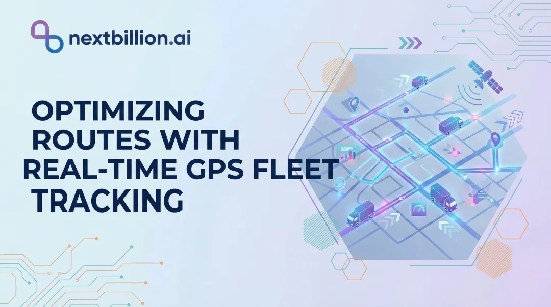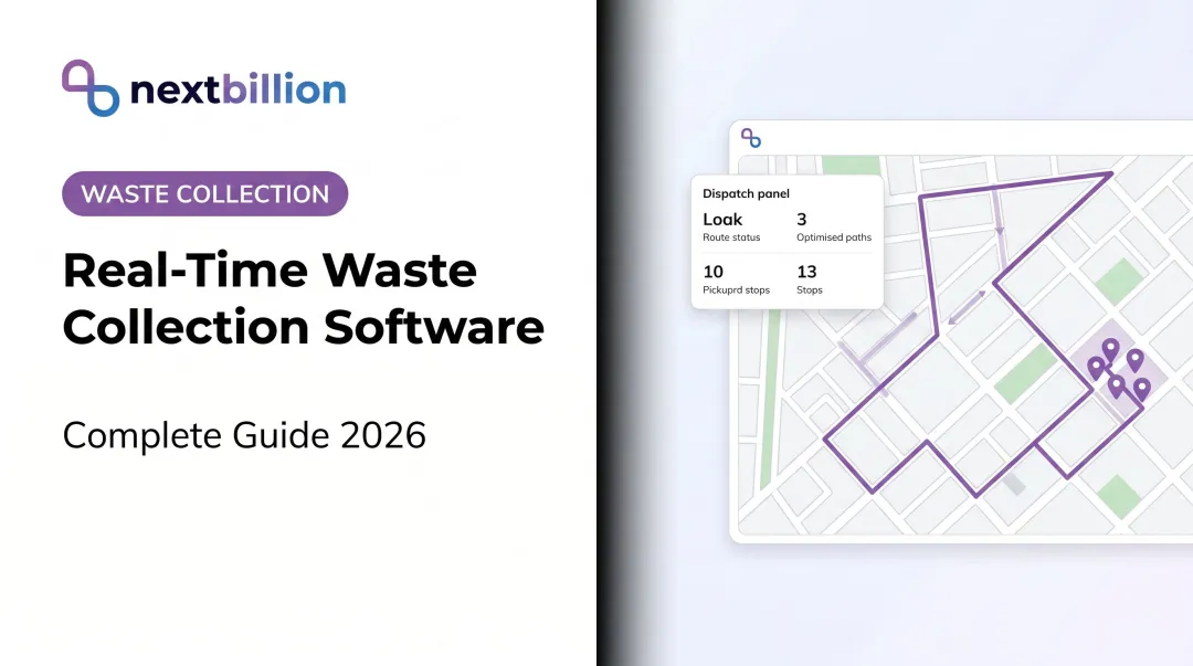
Fleet tracking has become standard infrastructure for waste haulers and municipalities trying to manage this complexity. But here's where many operators stall: they've deployed GPS hardware, they can see dots on a map, and they've stopped there. The route optimization, driver accountability data, proof-of-service records, and maintenance intelligence that make fleet tracking genuinely valuable go largely unused. Residents asking how to track a waste management service are usually pointed to a carrier portal or app, but the underlying value for the operator comes from the software layer connecting that GPS data to dispatch, billing, and compliance records.
This article covers how waste management fleet tracking actually works — from hardware through to reporting — and where the real operational gains come from.
Key Takeaways
- Waste management fleet tracking combines GPS hardware, telematics sensors, and cloud software to give supervisors real-time visibility across every vehicle.
- The system runs in four stages: hardware data capture → cellular transmission → alert/control layer → reporting output.
- Core benefits: route efficiency, fuel savings, driver safety coaching, proactive maintenance, and verified proof of service.
- Route optimization platforms like NextBillion.ai layer on top of existing telematics infrastructure, converting live location data into smarter dispatch decisions without replacing hardware.
What Is Waste Management Fleet Tracking?
Fleet tracking in waste management is a technology system that uses GPS devices, onboard sensors, and telematics software to monitor the location, movement, and operational status of collection vehicles in real time. It exists because, without it, supervisors have almost no visibility into what's actually happening in the field during a shift. The best software for waste management combines this GPS layer with route optimization, geofencing, and reporting tools rather than treating location data as a standalone map view, since GPS hardware alone answers where a truck is but not whether the route, driver behavior, or service record is actually improving.
The alternative — driver self-reporting, paper logs, end-of-day summaries — creates expensive blind spots:
- Missed stops that don't surface until a resident calls
- Idle time that burns fuel with no record
- Route inefficiencies that repeat daily because nobody can see them
- Unauthorized vehicle use outside service hours
Basic GPS shows a location. Full telematics-enabled fleet tracking goes further — adding engine diagnostics, driver behavior data, geofencing, and integration with dispatch and route optimization systems.
In practice, that gap means the difference between knowing a truck is somewhere on Route 7 versus knowing it's been idling for 40 minutes, has a pending fault code, and is running 90 minutes behind its stop sequence.
Asset tracking for dumpsters and containers is a related application (covered in the FAQ), but the core fleet tracking system centers on powered vehicles.
How Waste Management Fleet Tracking Works
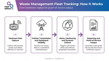
Waste management fleet tracking operates through four connected stages. Each one adds a layer of operational intelligence that the stage before it makes possible.
Hardware Installation and Data Capture
Tracking starts at the vehicle. GPS devices — either OBD-II plug-in units, hardwired telematics gateways, or harness-connected modules for vehicles without standard diagnostic ports — are installed on garbage trucks, roll-off vehicles, recycling units, and equipment. Geotab's GO device, for example, plugs directly into the OBD-II port without wire-splicing, while harness installations suit vehicles where the diagnostic port needs to stay accessible.
These devices capture continuously:
- GPS coordinates via satellite trilateration across the GNSS network
- Engine status, speed, and idle state
- Fuel usage and odometer data
- Fault codes and engine diagnostics
- Sensor inputs from collection mechanisms (compactor activation, lift cycles)
Real-Time Transmission and Dashboard Visibility
Captured data transmits over cellular networks to a cloud-based platform at configurable intervals — triggered by movement, elapsed time, or specific events. Supervisors access a consolidated dashboard from any browser or mobile device, with live position, speed, status, and route progress visible across the entire fleet simultaneously.
This is where operational awareness shifts from reactive to real-time. A dispatcher doesn't need to wait for a driver to call in a problem — the system surfaces it as it happens.
Alerts, Geofencing, and Dynamic Control
The rule-based control layer is where the system moves from observation to active management. Geofences define expected route corridors or service zones, and the platform triggers automatic alerts when:
- A vehicle deviates from its assigned route
- Idle time exceeds a configured threshold
- A truck enters or exits a defined area outside permitted hours
- A vehicle approaches or leaves a disposal facility
Corridor geofencing is particularly useful for enforcing contracted service routes and holding third-party haulers accountable. The system creates a verifiable record of whether a vehicle stayed within the designated service corridor throughout the shift.
For fleets that need this precision, NextBillion.ai's Geofencing API supports polygons, circles, corridors, and custom shapes with time-of-day and day-of-week scheduling — useful for waste fleets that must comply with residential collection windows or municipal regulations. Entry/exit event triggers generate real-time alerts, and geofences feed directly into the routing engine as restricted zones.
Route optimization platforms can also sit as an intelligent layer on top of tracking data. NextBillion.ai integrates directly with Geotab, Samsara, and Motive via bidirectional API connections: pulling live vehicle positions and stop sequences from existing telematics hardware, running optimization, and pushing updated routes back to driver apps. No hardware swap required.
Reporting and Proof-of-Service Output
Every movement, stop, event, and alert is logged with timestamps and compiled into structured reports. These include:
- Route completion records by vehicle and shift
- Stop-level service verification with arrival/departure times
- Idle time summaries and engine hour logs
- Geofence event histories and deviation records
NextBillion.ai's Route Reconstruction API transforms raw GPS breadcrumb data into road-snapped, audit-defensible trip records — capturing every road taken, every waypoint, and every distance — in formats exportable for compliance, billing, and dispute resolution.
Key Ways Fleet Tracking Streamlines Waste Operations
Fleet tracking addresses four operational domains where waste collection operators consistently lose money or service quality — often both at once.
Route Efficiency and Fuel Cost Reduction
GPS data surfaces route inefficiencies that aren't visible otherwise: overlapping coverage zones, suboptimal stop sequences, unnecessary deadhead miles, and excessive idle time. A typical refuse truck burns 8,500 to 10,000 gallons of fuel per year — and a meaningful portion of that goes to idle time and inefficient routing.
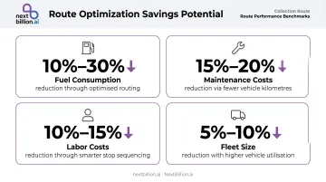
According to Waste360, collection route optimization can reduce:
- Fuel consumption by 10%–30%
- Maintenance costs by 15%–20%
- Labor costs by 10%–15%
- Fleet size by 5%–10%
These aren't one-time improvements. Route-level analytics allow dispatchers to reassign stop sequences and eliminate redundant miles on an ongoing basis — not just at implementation. For SIR, a waste management operator in Mexico City, NextBillion.ai's route optimization delivered a 13% reduction in miles driven per month and a 35% reduction in operating costs.
Driver Safety and Accountability
Waste collection is genuinely dangerous work. According to SWANA's 2026 statement on BLS data, refuse and recyclable materials collectors had a fatality rate of 37.4 per 100,000 full-time equivalent workers in 2024 — making it one of the most hazardous occupations in the US.
Telematics data on harsh braking, rapid acceleration, speeding, and extended idling builds objective driver behavior profiles. Supervisors can coach drivers with documented evidence rather than observation-based judgment, turning vague feedback into specific, defensible coaching conversations.
Dashcam integration adds another layer. Interstate Waste Services reported a 20% reduction in claims costs from intersection collisions in one year after deploying high-quality dashcam footage through Samsara. When a truck and a car collide at a congested intersection, timestamped video from the correct angle resolves the dispute in hours, not weeks.
Maintenance Scheduling and Fleet Uptime
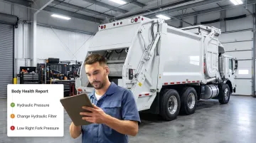
Telematics delivers real-time engine fault codes to fleet managers the moment a warning light appears — before a driver calls in a breakdown. That lead time lets dispatchers decide immediately: pull the vehicle and reroute, or send support to the field.
Engine hour tracking and mileage accumulation also feed automated maintenance scheduling. Service happens at the right interval based on actual usage, not just calendar dates.
That precision matters at scale. A single garbage truck costs approximately $300,000 to replace, and audits have found 66% of some refuse fleets in need of replacement. Proactive scheduling keeps those costs from landing all at once.
Proof of Service and Customer Dispute Resolution
GPS-timestamped route history provides a verifiable service record for every vehicle on every shift, down to the stop level. When a resident reports a missed pickup, a supervisor can retrieve the exact breadcrumb trail, stop time, and — in systems with dashcam integration — footage of the collection point.
Philadelphia's PickupPHL interactive map, launched in 2020, refreshes every 30–60 minutes using GPS data from sanitation vehicles. Residents can check route status themselves — reducing call volume and setting accurate expectations without dispatcher intervention.
What to Look For in a Waste Management Fleet Tracking System
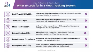
Not all fleet tracking solutions are built for waste operations. When evaluating platforms, prioritize:
Real-time GPS with centralized visibility
- Live location, speed, status, and route progress across all vehicle types simultaneously
- Coverage for trucks, equipment, and containers — not just one asset class
Telematics depth
- Engine diagnostics and fault codes, not just location
- Fuel consumption, idle time, and driver behavior data
- PTO and bin-lift activity monitoring for collection verification
Mixed fleet support
- Garbage trucks, roll-off units, recyclers, and street sweepers operate under different constraints
- The platform needs to handle varied asset classes with different capacity, time windows, and routing rules within the same optimization run
Integration capability
- Siloed tracking wastes its own potential — disconnected data means dispatchers still make decisions blind
- Look for native connections to route optimization engines, dispatch workflows, and dashcam systems
For a concrete example of what strong integration looks like: NextBillion.ai connects directly with Geotab, Samsara, and Motive via bidirectional API integrations, pulling vehicle and order data from existing telematics platforms and pushing optimized routes back to driver apps. Waste fleets can layer in route optimization with 50+ constraints — vehicle capacity, time windows, truck-compliant routing, return-to-dump logic, and curbside approach rules — without replacing any existing hardware.
Reporting and compliance output
- Exportable, audit-ready reports for contract compliance, billing verification, and regulatory documentation
- Stop-level service records, not just end-of-route summaries
Deployment flexibility
- Cloud options on AWS, Google Cloud, or Azure
- On-premise deployment for municipalities with data residency requirements
- NextBillion.ai is SOC 2 Type II and ISO 27001 certified, with on-premise Kubernetes deployment available for operators who need data to stay within their own infrastructure
Conclusion
Waste management fleet tracking functions as an operational intelligence system. Real-time location data, combined with telematics, alerts, and structured reporting, gives waste operators the visibility and evidence they need to reduce costs, improve service reliability, and manage geographically dispersed fleets with actual precision.
Operators who understand the full data flow — from hardware capture through to proof-of-service reporting — make better purchasing decisions and extract more value from their investment. Most operators already have the hardware in place. What separates efficient fleets from the rest is how well their software layer — route optimization, live tracking, and trip reconstruction — turns raw location data into decisions. That's where platforms like NextBillion.ai, which integrates with Geotab and Samsara and adds route optimization and audit-grade trip reconstruction on top, close the gap between data collected and value realized.
Frequently Asked Questions
How much does GPS tracking for waste management software cost, and are there free options?
Fleet GPS tracking typically runs $20–$45 per vehicle per month for standard commercial platforms. Enterprise waste operations often see different pricing based on feature depth and contract terms, so evaluate total cost — hardware, installation, onboarding, and support — not just the monthly license. Free options are essentially nonexistent at operational scale. Route optimization, driver behavior scoring, and container-level tracking usually sit in separate pricing tiers, so confirm what is bundled before comparing vendor quotes line by line.
How do I track waste management using GPS tracking software?
Install GPS tracking hardware on vehicles and assets, connect devices to a cloud-based fleet management platform, then configure dashboards, alerts, and geofences. Most modern platforms complete initial setup within days. From there, route history, idle time reports, and service records generate automatically. Pair this with route optimization APIs so dispatchers see planned versus actual stop sequences side by side, which makes it easier to spot deviations, verify FMCSA hours-of-service compliance, and adjust routes before a shift ends rather than after the fact.
What is the difference between GPS tracking and route optimization for waste fleets?
GPS tracking tells you where vehicles are and have been. Route optimization uses that location data — plus stop sequences, vehicle constraints, and traffic conditions — to determine where vehicles should go next. Integrated together, tracking feeds real-world data into the optimization engine, improving dispatch decisions continuously.
Can waste management fleet tracking help reduce missed pickups?
Yes. GPS timestamp data and stop-level service records show exactly which stops were serviced and when. Kansas City implemented Rubicon's smart-city platform and saw a 20% reduction in missed pickups in certain areas. Supervisors can verify completion in real time and re-dispatch within minutes when a stop was genuinely skipped.
Does fleet tracking work for containers and dumpsters, not just trucks?
Battery-powered asset trackers — such as Samsara's Unpowered Asset Gateway, which runs 3–5 years on replaceable AA batteries — can be installed on dumpsters, roll-off containers, and other non-powered assets. These monitor location, geofence breaches, movement alerts, and utilization, extending operational visibility well beyond the truck fleet.
How can I track my waste management service?
Most municipal and commercial waste haulers now provide customer-facing portals or apps where you can view scheduled pickup windows and, in some cases, real-time truck location for your route. If your provider does not offer this, ask whether they use a fleet management platform with GPS tracking. Behind the scenes, the same location and stop-completion data used for customer visibility also drives internal route and dispatch decisions.
What is the best software for waste management?
There is no single best platform; the right choice depends on fleet size, whether you need route optimization alongside tracking, and how well the software integrates with existing dispatch or billing systems. Look for platforms that combine GPS tracking, route optimization APIs, geofencing, and reporting in one system, since stitching together separate point solutions usually creates data gaps between what dispatch plans and what actually happens on the road.