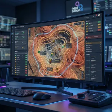
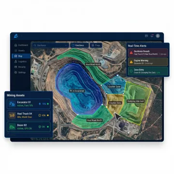
What types of geofences can be created for a mine site?
NextBillion.ai supports polygons, circles, corridors, and custom-shape geofences — all definable via the platform interface, GeoJSON import, or API. For mining, this means you can accurately trace irregular blast exclusion zones, pit perimeters, access corridors, and equipment staging areas rather than relying on imprecise radius circles that leave gaps or over-restrict operational areas.
Can geofences be scheduled to activate only during specific operational windows?
Yes. Every geofence can be configured with time-of-day and day-of-week schedules. For mining, this means blast exclusion zones can automatically activate during designated blast windows, shift change restrictions can apply during handover periods, and equipment-only corridors can enforce access rules only during active mining hours — all without manual intervention.
How does the system handle asset tracking in low-connectivity underground or remote mine areas?
The Live Tracking API supports offline tracking mode, which buffers location data locally on the device when connectivity is lost and synchronizes it automatically when signal is restored. This ensures continuous, uninterrupted tracking records for underground equipment, remote haul roads, and areas with intermittent cellular or satellite coverage — maintaining compliance documentation integrity regardless of network conditions.
Can the platform generate compliance documentation for mining safety regulators?
Yes. The Route Reconstruction API produces time-stamped, road-snapped trip records for every tracked asset — including complete boundary event logs showing zone entries, exits, and dwell times. These records are audit-ready and designed to satisfy regulatory inspection requirements, support incident investigations, and provide defensible proof-of-compliance documentation for mining safety authorities and insurance auditors.
How many geofences and assets can be monitored simultaneously?
NextBillion.ai's platform is engineered for enterprise-scale operations with no hard caps on simultaneous geofences or tracked assets. Mining operations running dozens of haul trucks, light vehicles, and personnel carriers across multiple active zones can monitor all assets concurrently, with real-time event processing and alert delivery maintaining performance at full fleet scale.
Does the geofencing system integrate with existing mine fleet management or telematics platforms?
Yes. NextBillion.ai integrates natively with leading telematics platforms including Samsara and Geotab, and connects to custom fleet management systems via REST API. Geofence event data, asset location feeds, and boundary alert notifications flow directly into your existing operational dashboards, dispatch consoles, and safety management systems without requiring a parallel monitoring interface.
Is on-premise deployment available for sites with strict data sovereignty or air-gapped network requirements?
Yes. NextBillion.ai offers full on-premise deployment via Kubernetes, enabling the complete geofencing and tracking stack to run within your own infrastructure — whether a private cloud, on-site data center, or isolated mine site network. This option is specifically suited for mining operations subject to government data residency mandates or operating in remote locations without reliable external connectivity.
What does implementation and onboarding look like for a mining operation?
Deployment typically goes live within one week, including trial onboarding, mine site data configuration, and production API integration. NextBillion.ai's solutions engineering team provides hands-on 24/7 support throughout setup and beyond — helping operations teams define geofence boundaries, configure asset profiles, connect existing telematics hardware, and validate alert workflows before going live across the full site.