Geofencing API
Define, manage, and monitor custom virtual geographic boundaries — polygons, circles, corridors, or custom shapes — and trigger real-time automated workflows the moment an asset enters, exits, or dwells within any zone.
NextBillion.ai's Geofencing API & SDK empowers logistics operators, fleet managers, and developers to define custom virtual boundaries and trigger real-time automated actions the instant an asset crosses them. From proof-of-delivery automation to restricted zone enforcement and proximity-based dispatch, transform raw location data into operational intelligence — without manual monitoring or runaway API costs.
Comprehensive geofencing capabilities to automate workflows, enforce boundaries, and power real-time location intelligence for any fleet or platform.
Define, manage, and monitor custom virtual geographic boundaries — polygons, circles, corridors, or custom shapes — and trigger real-time automated workflows the moment an asset enters, exits, or dwells within any zone.
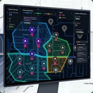
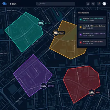
Fire automated event notifications for proof-of-delivery, depot check-ins, customer ETA alerts, unauthorized asset movement, and curbside pickup readiness the instant a boundary event is detected.
Designate geofences as routing no-go zones fed directly into the routing engine, automatically keeping vehicles away from congested areas, school zones, or compliance-sensitive restricted sites.
Use geofencing in conjunction with isochrone calculations to allocate delivery or service territories and enable smart proximity matching — pairing orders or passengers to the nearest available asset instantly.
Receive instant alerts when high-value cargo or fleet vehicles move outside authorized operating areas or predefined safe zones, enabling proactive security response without manual oversight.
Trigger personalized push notifications, promotional offers, and loyalty rewards when customers or delivery vehicles approach defined locations — powering curbside pickup and location-based retention programs.
NextBillion.ai's Geofencing API & SDK goes far beyond drawing circles on a map. Geofences integrate natively with the routing engine, live tracking, and dispatch workflows — so a boundary crossing doesn't just log an event, it triggers proof-of-delivery confirmation, re-routes a vehicle, reassigns a task, or notifies a customer automatically. For logistics platforms and fleet operators managing hundreds of concurrent assets, this eliminates the manual monitoring overhead that erodes operations team capacity and creates costly delays.
See how global logistics operators and mobility platforms use NextBillion.ai's Geofencing API to automate workflows and cut operational costs.
"I admire NextBillion.ai's fast response and friendly manners whenever we need professional support in geospatial data processing. They have delivered a valuable service and support to our company that we appreciate."

"By substantially reducing the number of developer hours spent on scheduling, NextBillion.ai's MVRP and large Distance Matrix API have helped us improve our operational efficiency and increase our cost savings significantly!"

"Support very good and friendly. Nextbillion provide the maps distance calculation with the low price but high value service to us. Nextbilions has help us reduce the cost and provide the same service as google!"
"Rich in features, light in the pocket. NextBillion.ai is solving the complex processes of the best route for the right vehicle."

"We were unhappy with the pricing from big players in this space and needed a scalable alternative that offered customizability. NextBillion.ai's Maptiles API was exactly what we were looking for. For companies in the ferry and nautical map domain, we'd highly recommend NextBillion.ai."
"I admire NextBillion.ai's fast response and friendly manners whenever we need professional support in geospatial data processing. They have delivered a valuable service and support to our company that we appreciate."
"By substantially reducing the number of developer hours spent on scheduling, NextBillion.ai's MVRP and large Distance Matrix API have helped us improve our operational efficiency and increase our cost savings significantly!"
"Support very good and friendly. Nextbillion provide the maps distance calculation with the low price but high value service to us. Nextbilions has help us reduce the cost and provide the same service as google!"
"Rich in features, light in the pocket. NextBillion.ai is solving the complex processes of the best route for the right vehicle."
"We were unhappy with the pricing from big players in this space and needed a scalable alternative that offered customizability. NextBillion.ai's Maptiles API was exactly what we were looking for. For companies in the ferry and nautical map domain, we'd highly recommend NextBillion.ai."
Built by veterans of Grab's Geo team, NextBillion.ai delivers enterprise-grade geofencing with the flexibility, pricing transparency, and integration depth that generic mapping APIs simply cannot match.
Geofencing events connect directly to routing, dispatch, and live tracking APIs — enabling end-to-end automated workflows without custom middleware.
Per-vehicle and per-order pricing models eliminate per-API-call cost explosions as geofence event volumes scale with fleet growth.
A 99.9% uptime SLA, SOC 2 Type II certification, and on-premise deployment options ensure geofencing infrastructure that enterprises can depend on.
Dedicated solutions engineering support available around the clock accelerates integration and resolves production issues for global fleet operations.
Location intelligence veterans building enterprise geofencing for the real world.

Co-Founder
Ajay Bulusu is a co-founder of NextBillion.ai, bringing deep expertise in geospatial technology and large-scale location platform engineering. His journey began in 2017 as part of Grab's pioneering Geo team, where he helped build the location infrastructure underpinning one of Southeast Asia's largest mobility and logistics platforms. That experience revealed how critical — and how underserved — accurate, flexible location technology was for real-world operations. Driven by a mission to democratize sophisticated location intelligence, Ajay co-launched NextBillion.ai in 2020. Under his technical leadership, the platform has scaled to serve 150+ businesses globally, optimize over 10.9 million deliveries and field tasks, and deliver more than $11 million in documented cost savings to customers.

Co-Founder
Gaurav Bubna drives product innovation at NextBillion.ai, bringing a proven track record of building successful products from scratch across ride-hailing, food delivery, and logistics. Before co-founding NextBillion.ai, Gaurav held product leadership roles at Grab, Ola, and Morgan Stanley — organizations where location technology and operational efficiency are existential. His time on Grab's Geo team alongside Ajay and Shaolin crystallized the vision: logistics and field service businesses needed enterprise-grade location intelligence without prohibitive per-call pricing. Since launching NextBillion.ai in 2020, Gaurav has led the product evolution that has helped the platform navigate over 557 million miles and raise $34.25M in venture capital from investors including Lightspeed and Microsoft's M12.

Co-Founder
Shaolin Zheng is a co-founder of NextBillion.ai, contributing deep technical expertise in geospatial systems and scalable mapping infrastructure. Like his co-founders, Shaolin's formative experience building location technology for Grab's Geo team gave him firsthand insight into the operational gaps that generic mapping solutions leave unaddressed — particularly for field service and logistics businesses operating at scale. His engineering perspective shapes NextBillion.ai's core philosophy: location technology must be customizable, cost-predictable, and production-reliable. The platform he helped build now powers GPS tracking, route optimization, and field service intelligence for over 150 businesses worldwide, with on-premise deployment options and SOC 2 Type II and ISO/IEC 27001:2013 certifications ensuring enterprise-grade security.
Geofencing in software is the practice of defining a virtual geographic boundary — a polygon, circle, or custom shape — around a real-world location, and programming automated actions to occur when a tracked asset (vehicle, device, or person) enters, exits, or lingers within that boundary. In logistics and fleet management software, geofencing powers proof-of-delivery automation, arrival alerts, restricted zone enforcement, and proximity-based dispatch without manual monitoring.
Talk to a NextBillion.ai solutions engineer for a personalized walkthrough and free trial setup.

Consistently rated 4.6+ across top software review platforms.
Enterprise security and data privacy compliance verified.
International information security management standard certification.
Tell us about your use case and a solutions engineer will respond within one business day with a tailored demo, trial API access, and integration guidance — no sales pressure, just technical answers.
To help us assist you faster, please include the reason for your message so the relevant team can reach out as soon as possible.
To help us assist you faster, please include the reason for your message so the relevant team can reach out as soon as possible.