in 2026](https://file-host.link/website/nextbillion-27cay0/assets/blog-images/65c39259-77f4-4d2a-a307-4e9e0614851e/1780082539376429_7dde6695d71845d59eff75b4f51bb5fe/360.webp)
For logistics companies, fleet operators, last-mile delivery platforms, and field service teams making millions of API calls monthly, this isn't just inconvenient. Unpredictable per-call billing is a genuine operational risk. A single traffic spike or batch geocoding job can generate unexpected charges at scale.
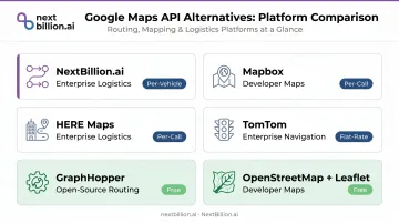
Alternatives to Google Maps API fall into three categories: open-source tools like OpenStreetMap, Leaflet, and GraphHopper, which eliminate licensing costs entirely; developer-focused platforms like Mapbox and MapTiler, built for customization; and enterprise-grade logistics solutions designed for fleet and delivery use cases. This post covers the 12 best Google Maps API alternatives available in 2026 — spanning open-source tools, developer-focused platforms, and enterprise-grade logistics solutions — so you can find the right fit for your use case and budget.
Key Takeaways
- Google Maps API's per-call pricing creates budget unpredictability for high-volume logistics and fleet applications
- Open-source options (OpenStreetMap, Leaflet, GraphHopper) eliminate licensing costs entirely
- Mapbox and MapTiler are strong choices for developer-heavy, customization-focused applications
- For logistics and fleet operations, NextBillion.ai offers purpose-built APIs with per-vehicle/per-order pricing and 50+ routing constraints, making it a direct alternative to per-call billing
- The right alternative depends on your use case — pricing model, routing depth, and data coverage matter more than brand recognition
Why Businesses Are Switching Away from Google Maps API
The Pricing Problem
Google introduced mandatory billing accounts on June 11, 2018, replacing its previously free tier. Today, the platform operates on pay-as-you-go pricing per SKU, with 10,000 free events per month for core services — after which charges apply:
| API | Free Monthly Limit | Cost Per 1,000 Calls After |
|---|---|---|
| Static Maps | 10,000 | $2.00 |
| Dynamic Maps | 10,000 | $7.00 |
| Geocoding | 10,000 | $5.00 |
| Directions | 10,000 | $5.00 |
| Distance Matrix | 10,000 | $5.00 |
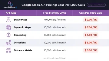
For a logistics platform running 500,000 geocoding calls per month, that's roughly $2,450 in geocoding alone — before routing, distance matrix, or map tile costs.
Functional Limitations at Scale
Cost alone doesn't tell the full story. As call volume scales, Google's hard API caps start compounding the billing problem with operational ones:
- 25×25 element limit: The legacy Distance Matrix API supports a maximum of 25 origins or 25 destinations, with 100 elements per request. Even the newer Route Matrix service caps at 625 route elements
- No complex vehicle constraints: Google's routing doesn't support truck height/weight restrictions, hazmat routing, or multi-depot optimization natively
- Caching restrictions: Google's Terms of Service prohibit caching geocodes, directions, and Distance Matrix results — making it difficult to build address databases or offline-capable logistics tools
- Limited map customization: Enterprise-grade map editing (custom road attributes, speed limits, closures) isn't available
Data Sovereignty Concerns
Using Google Maps API means routing data passes through Google's infrastructure. For many enterprise buyers, that's a non-starter. Affected segments include:
- GDPR-regulated businesses handling EU customer location or delivery data
- Government contractors subject to data residency or sovereignty requirements
- Enterprises with confidentiality mandates where route data reveals competitive operational patterns
On-premise and private-cloud deployment options exist specifically to address these constraints — and they're a primary reason logistics teams evaluate self-hosted alternatives.
12 Best Google Maps API Alternatives in 2026
These alternatives span developer tools, general-purpose mapping platforms, and logistics-specialized solutions — evaluated on mapping quality, routing capabilities, pricing model, and fit for specific industries.
1. NextBillion.ai
NextBillion.ai is an enterprise-grade location intelligence platform purpose-built for logistics, fleet, and field service operations. The three co-founders — Ajay Bulusu, Gaurav Bubna, and Shaolin Zheng — all worked on Grab's Geo team starting in 2017, where they experienced firsthand the limitations of generic mapping APIs at operational scale. Since launching NextBillion.ai in 2020, the platform has served 150+ businesses globally, optimized 10.9M+ deliveries and field tasks, and delivered $11M+ in documented customer cost savings.
What makes it different from Google Maps API:
The core differentiator is pricing structure. NextBillion.ai uses per-vehicle or per-order pricing — not per-API-call — so costs stay predictable regardless of API volume. Fixed monthly plans start at $200/month for 2,500 orders, with enterprise custom pricing available.
On the technical side:
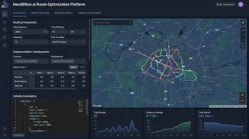
- 50+ hard and soft routing constraints — time windows, vehicle capacity, skill-based technician matching, HOS compliance, hazmat routing, truck height/width/weight restrictions, axle load limits
- Distance Matrix up to 5,000×5,000 elements (versus Google's 625-element cap), processing thousands of origin-destination pairs in a single API call
- Custom map editing via the Road Editor App: set custom speed limits, road closures, turn restrictions, no-entry zones, and plying permissions by vehicle type and time of day; changes feed directly into routing APIs with no lag
- Sub-second routing latency with 99.9% uptime guarantee, and benchmarked at 2x–3x lower latency than comparable implementations
- On-premise and private cloud deployment on AWS, GCP, or Azure; routing data never leaves your infrastructure, satisfying GDPR and data sovereignty requirements
Enterprise credentials: SOC 2 Type II, ISO/IEC 27001:2022, GDPR and CCPA compliant. Native integrations with Samsara, Geotab, Motive, Netradyne, and Verizon Connect. 24×7 support from solution engineers included.
Real-world results: Xpress Global Systems achieved a 35% reduction in operating costs and 13% fewer miles driven per month. A European TMS provider reduced API costs by 82% without compromising ETA accuracy.
| Category | Details |
|---|---|
| Key Features | Route optimization with 50+ constraints, 5,000×5,000 distance matrix, truck routing, GPS tracking, custom map editing, field service scheduling |
| Best For | Logistics companies, last-mile delivery, fleet management, field service, NEMT, and ride-sharing platforms with high API volumes |
| Pricing Model | Per-vehicle or per-order (not per-API-call); fixed plans from $200/month — see nextbillion.ai for current tiers |
2. Mapbox
Mapbox is one of the most widely used developer-facing mapping platforms, known for highly customizable vector maps and a rich SDK ecosystem. Companies including Snapchat (Snap Map), DoorDash, and The Weather Channel run on Mapbox infrastructure. Map data draws from OpenStreetMap, Microsoft Open Maps, Wikidata, and proprietary Mapbox sources.
Why developers choose it: Deep map style customization through Mapbox Studio, 3D maps, AR navigation, and robust SDKs for iOS, Android, and web. The free tier includes 50,000 web map loads/month and 100,000 Directions API requests/month, with pay-as-you-go rates after that ($5/1,000 web map loads; $2/1,000 Directions API calls).
| Category | Details |
|---|---|
| Key Features | Custom map styles, 3D maps, geocoding, routing, navigation SDKs, data visualization, AR navigation |
| Best For | Developers building consumer apps, ride-sharing UIs, retail location experiences |
| Pricing Model | Free tier available; pay-as-you-go per map load/API call beyond free limits |
3. HERE Maps
HERE Technologies grew out of NAVTEQ and Nokia's mapping division, and was acquired in 2015 by Audi, BMW Group, and Daimler, which established its automotive-grade credibility. It's a go-to for OEM navigation systems, enterprise logistics, and applications requiring offline reliability.
Differentiators: Real-time traffic integration, truck routing, indoor mapping, fleet management APIs, and offline map downloads. The HERE Routing API supports advanced truck routing, large-scale matrix routing, and traffic-enabled routing. Pricing follows a freemium model with pay-as-you-grow beyond base quotas — verify current limits at here.com/get-started/pricing.
| Category | Details |
|---|---|
| Key Features | Traffic-aware routing, geocoding, truck routing, indoor maps, fleet tracking APIs, offline maps, transit data |
| Best For | Automotive applications, logistics, fleet management, enterprise apps requiring offline reliability |
| Pricing Model | Freemium base plan; pay-as-you-grow beyond limits |
4. TomTom
TomTom is a veteran navigation company with mapping data across 200+ countries and territories, powering enterprise customers and automotive OEMs with high-accuracy road data and real-time traffic. Microsoft Azure Maps, Bing, and Uber all run on TomTom's mapping and traffic infrastructure.
Differentiators: Dedicated APIs for traffic flow and incidents, EV routing with battery management integration, logistics routing, and geofencing. The free developer tier includes 50,000 tile requests daily and 2,500 non-tile requests daily — no credit card required.
| Category | Details |
|---|---|
| Key Features | High-accuracy maps, real-time traffic, EV routing, logistics routing, geocoding, map tiles, geofencing |
| Best For | Navigation apps, fleet management, automotive integrations, real-time traffic-sensitive applications |
| Pricing Model | Freemium; 50,000 free tile requests/day, 2,500 non-tile requests/day, no card required |
5. OpenStreetMap + Leaflet
OpenStreetMap (OSM) is a free, community-maintained world map dataset available under the Open Database License (ODbL). Paired with Leaflet — the leading open-source JavaScript mapping library — it offers a completely free mapping solution with no signup or API key required.
The trade-off: OSM data quality varies by region, and neither OSM nor Leaflet provides routing natively. For routing, pair with OpenRouteService, which is free and open-source. Best for projects where eliminating cost is the primary goal.
| Category | Details |
|---|---|
| Key Features | Free map tiles, interactive web maps, marker/popup support, mobile-friendly, no API key required |
| Best For | Websites, store locators, non-commercial projects, zero-cost deployments |
| Pricing Model | Completely free; high-volume tile usage requires self-hosting or a commercial tile provider |
6. Azure Maps
Azure Maps is Microsoft's enterprise mapping platform — powered by TomTom data — integrated within the Azure cloud ecosystem. It covers maps, geocoding, routing, traffic, weather, and IoT location services, with native Power BI integration and Azure AD security.
The obvious fit: organizations already on Azure infrastructure. Azure Maps requires an Azure subscription but offers pay-as-you-go pricing with a free monthly transaction quota. Check current S0 tier pricing at azure.microsoft.com/pricing/details/azure-maps.
| Category | Details |
|---|---|
| Key Features | Vector maps, geocoding, routing, traffic, weather, IoT integration, indoor maps, Azure AD security |
| Best For | Enterprises on Microsoft Azure, logistics + IoT integrations, apps needing enterprise-grade SLAs |
| Pricing Model | Requires Azure account; pay-as-you-go with a free monthly quota |
7. Radar
Radar is a full-stack geolocation platform handling over 100 billion API calls per year from 100+ million devices. It combines maps, geocoding, routing, geofencing, and location-based marketing tools in a single platform — positioning itself as a cost-effective Google Maps replacement for retail and app-first use cases.
The standout capability is geofencing: polygon geofences, dwell-time triggers, and chained geofence logic that makes it particularly useful for retail, restaurants, and fraud detection. Verify current free tier limits and paid plan rates at radar.com.
| Category | Details |
|---|---|
| Key Features | Geocoding, routing, geofencing, address autocomplete, place detection, vector basemaps |
| Best For | Retail and restaurant apps, location-triggered marketing, fraud detection, maps + geofencing combined |
| Pricing Model | Free tier available; paid plans based on monthly API calls |
8. MapTiler
MapTiler is an OSM-based mapping platform offering professionally styled vector and raster tiles with a developer-friendly free tier that requires no credit card to start. It gained significant traction following Google's 2018 pricing changes and supports custom map styles, high-DPI tiles for retina displays, geocoding, and routing APIs. Self-hosting is available alongside cloud service. Check current free tier limits at maptiler.com.
| Category | Details |
|---|---|
| Key Features | Custom map styles, vector tiles, satellite imagery, geocoding, offline maps, self-hosting option |
| Best For | Web developers, small-to-mid-size businesses needing polished maps without credit card friction |
| Pricing Model | Free tier (no card required); paid plans for higher usage |
9. Geoapify
Geoapify is an OSM-powered location platform offering maps, geocoding, routing, places API, and static maps — with one of the most generous free tiers for commercial use among OSM-based providers. It's designed for easy integration with Leaflet, OpenLayers, or MapLibre, and allows limited commercial use on the free plan without a credit card — making it attractive for startups and prototypes. See current daily credit limits at geoapify.com/pricing.
| Category | Details |
|---|---|
| Key Features | Geocoding, routing, places search, static maps, OSM tiles, isochrones |
| Best For | Startups, prototype development, OSM-based projects needing commercial use within a free tier |
| Pricing Model | Free plan with daily credit limit; paid plans available |
10. GraphHopper
GraphHopper is an open-source routing engine built on OSM data, offering fast and customizable route calculation for car, bike, pedestrian, and multi-modal transport. Available as a hosted API or fully self-hostable — making it unique among routing solutions in that licensing costs can be eliminated entirely.
Beyond basic routing, it includes route optimization (TSP/VRP for multi-stop problems), Map Matching API (GPS trace snapping to roads), Isochrone API, and a Matrix API. Strong choice when routing is the primary requirement and you're handling map display separately. Check hosted plan pricing at graphhopper.com.
| Category | Details |
|---|---|
| Key Features | Fast routing, route optimization (VRP), map matching, isochrone analysis, matrix API, multi-modal |
| Best For | Developers needing a standalone routing engine; open-source and self-hosted logistics tools |
| Pricing Model | Open-source (self-hosted, free); hosted API has a free tier |
11. OpenLayers
OpenLayers is a free, open-source JavaScript library (BSD 2-Clause License) for building interactive web maps. It supports tile sources from OSM, Bing Maps, Mapbox, and custom servers — alongside vector layers, WMS/WFS, GeoJSON, KML, and advanced projections.
The caveat: OpenLayers doesn't provide map data or routing on its own, and requires meaningful developer investment to configure. Best for teams building custom GIS-heavy applications where flexibility matters more than out-of-the-box convenience.
| Category | Details |
|---|---|
| Key Features | Interactive web maps, multiple tile sources, vector layers, GeoJSON/KML, advanced projections |
| Best For | Web developers building custom GIS applications or needing flexible data layer visualization |
| Pricing Model | Completely free and open-source; tile hosting costs depend on the provider chosen |
12. Apple Maps (MapKit JS)
Apple Maps via MapKit JS offers map display, search, and directions integrated with Apple's ecosystem. It includes a generous free daily usage quota per Apple Developer account — verify current limits at developer.apple.com. Authentication uses JWT tokens, and an Apple Developer Program membership is required.
iOS-first teams will get the most out of it. Cross-platform or logistics-heavy applications that need truck routing, fleet APIs, or large matrix computations will need to look elsewhere.
| Category | Details |
|---|---|
| Key Features | Map display, location search, directions, annotations, overlays, Apple ecosystem integration |
| Best For | iOS app developers and Apple ecosystem-focused products |
| Pricing Model | Free up to a daily map view/service call quota per Apple Developer account |
How We Chose These Alternatives
The selection above was evaluated on five criteria — and each one ties directly to business outcomes:
- Per-call pricing looks affordable at low volumes and becomes unmanageable at scale. Look for per-vehicle, per-order, or flat-rate plans — pricing model predictability matters more than free tier generosity
- Routing and geocoding capability: Truck height restrictions, time windows, and multi-depot optimization aren't available in most general-purpose mapping APIs — confirm the API handles your actual constraint set
- Data coverage and accuracy: Global coverage claims vary significantly by region. Test with your actual operational geography before committing
- Integration and documentation quality: Poor documentation translates to higher engineering costs and longer deployment timelines
- Enterprise readiness: SLAs, security certifications, and support responsiveness matter when routing failures affect real deliveries
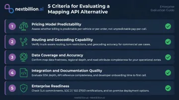
The most common evaluation mistake is choosing based on free tier limits. Cost overruns, constraint failures, and unsupported incidents only surface at production volume — by then, switching is expensive. Run each candidate against your actual traffic and constraint profile before committing.
Conclusion
The right Google Maps API alternative depends entirely on your use case.
- Simple web maps and store locators: OpenStreetMap + Leaflet or MapTiler eliminate cost without complexity
- Developer-focused consumer apps: Mapbox and MapTiler offer strong customization with transparent pricing
- Automotive and enterprise navigation: HERE and TomTom bring OEM-grade accuracy and offline capability
- Logistics, fleet management, and field service: NextBillion.ai, HERE, and TomTom offer the truck-compliant routing, large-scale distance matrix support, and traffic-aware ETAs that generic APIs don't provide
For logistics, fleet, and field service teams that have outgrown generic APIs, NextBillion.ai covers the operational depth that matters: predictable pricing, 50+ routing constraints, a 5,000×5,000 distance matrix, and 24×7 support from solution engineers.
Book a demo or explore the API documentation to see how it fits your stack.
Frequently Asked Questions
Is the Google Maps API still free?
Google Maps API is not free. It requires a billing account linked to a credit card, provides 10,000 free events per month per API, and charges per 1,000 calls beyond that. New customers receive a one-time $300 trial credit, but the previous $200 monthly credit has been replaced by per-SKU free usage caps.
Is there a free alternative to Google Maps API?
OpenStreetMap + Leaflet requires no account or API key. MapTiler and Geoapify offer free tiers without a credit card. GraphHopper is self-hostable at zero licensing cost, using open-source routing built on OSM data.
What is a good replacement for Google Maps?
The best replacement depends on your use case:
- Mapbox — customizable maps for developer applications
- HERE or TomTom — enterprise navigation and traffic data
- OpenStreetMap — zero-cost open-source mapping
- NextBillion.ai — logistics and fleet operations with advanced route optimization and no per-call fees
Which alternative is best for logistics and fleet management?
NextBillion.ai, HERE Maps, and TomTom are the strongest choices for logistics and fleet. All three offer truck-compliant routing, traffic-aware ETAs, and large-scale distance matrix support — capabilities general-purpose mapping APIs don't provide. NextBillion.ai also adds multi-stop VRP optimization with 50+ constraints and per-vehicle pricing. For US fleets, truck-compliant routing matters for staying within FMCSA hours-of-service limits and avoiding restricted roads, so route accuracy directly affects compliance, not just delivery speed.
How does Google Maps API pricing compare to alternatives?
Google charges per API call — per map load, geocoding request, or route calculation — which scales unpredictably. Alternatives like NextBillion.ai use per-vehicle or per-order pricing, open-source tools eliminate fees entirely, and platforms like TomTom offer generous daily free tiers with no credit card required.
Can I switch from Google Maps API without rebuilding my app?
Most alternatives offer REST APIs with similar endpoint structures to Google's. NextBillion.ai, Radar, and HERE provide migration guides and dedicated engineering support. The main effort involves updating endpoints, authentication tokens, and map rendering components — manageable without a full rebuild. Run both providers in parallel during testing to compare geocoding accuracy and ETA output before cutting over fully, since address formats and routing logic can differ enough to affect production behavior.
Is there a free GPS API available?
Yes, several options provide GPS and location functionality without cost. OpenStreetMap-based tools like Leaflet and GraphHopper are free and open-source, though self-hosting requires engineering effort. MapTiler and Geoapify offer free tiers for basic geocoding and mapping. Free tiers typically cap request volume and may lack features like truck routing, live traffic, or fleet-grade tracking, so evaluate limits against your actual usage before committing.