How does GPS tracking improve efficiency in waste management fleet operations?
GPS tracking gives waste fleet managers real-time visibility into every vehicle's location, route adherence, and idle time. This data enables dispatchers to reroute trucks around road closures or unexpected delays, reduce unproductive idle time, enforce driver compliance with planned collection circuits, and generate accurate mileage records—collectively cutting fuel costs and improving the number of completed collection stops per shift.
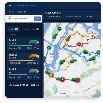
Can NextBillion.ai's GPS tracking handle large waste management fleets with hundreds of vehicles?
Yes. NextBillion.ai's platform is engineered for high-scale operations. The Live Tracking API supports simultaneous tracking of large vehicle fleets with sub-meter location accuracy, and the Distance Matrix API processes up to 5,000 x 5,000 origin-destination pairs in a single call—ensuring that route planning and real-time monitoring remain fast and reliable regardless of fleet size or operational complexity.
Does the platform support truck-specific routing for heavy waste collection vehicles?
Absolutely. NextBillion.ai's routing engine is vehicle-dimension-aware. You can specify vehicle height, weight, axle load, and length to generate routes that automatically avoid weight-restricted bridges, low-clearance underpasses, and truck-prohibited streets—ensuring waste collection vehicles are never routed into roads they cannot legally or safely traverse.
How does geofencing work for waste management depots and transfer stations?
You can define custom geofence boundaries around depots, transfer stations, landfills, and customer collection points using polygons, circles, or custom shapes. When a waste truck enters or exits a boundary, the system fires real-time event triggers—automating proof-of-service logging, depot check-in timestamps, and unauthorized movement alerts without requiring manual dispatcher monitoring.
Can the platform generate compliance documentation for regulated waste hauling operations?
Yes. The Route Reconstruction API rebuilds complete, road-snapped trip records from raw GPS data, producing audit-ready documentation with timestamps, road segment identifiers, distances, and route histories. This verifiable record supports regulatory compliance reporting, incident investigations, and customer SLA verification for hazardous and non-hazardous waste hauling operations.
How does NextBillion.ai integrate with existing telematics systems used by waste fleets?
NextBillion.ai integrates natively with leading telematics platforms including Samsara and Geotab, as well as TMS, ERP, and fleet management systems. The platform is also available as REST APIs and SDKs for Android, iOS, and Flutter, enabling integration into custom driver apps and dispatch consoles your team already operates.
What kind of driver behavior monitoring is available for waste fleet management?
The Snap-to-Road API and Live Tracking API together deliver segment-level driver behavior analytics: speed limit violations on specific road types, excessive idling, route deviations from planned collection circuits, harsh braking patterns, and time spent at rest stops versus in transit. This data powers driver performance scoring, safety training prioritization, and fuel efficiency programs across your fleet.
What pricing model does NextBillion.ai use for waste management fleet GPS tracking?
NextBillion.ai offers per-vehicle and per-order pricing rather than per-API-call models. This means that high re-optimization frequency, seasonal fleet expansions during peak demand, and batch planning runs don't generate unpredictable cost spikes. Waste management operators get a predictable monthly cost aligned to their actual fleet size, not to the volume of computational activity the platform performs.