Table of Contents
Transportation companies delivering🚚 goods across borders often face difficulty in matching timezones, and thus fail to cater to the orders on time. It is the problem of timezone-aware logistics that requires tracking systems to recognize and adjust according to the local time zones in the sequence of locations.
The platform should automate the route schedules and deliveries such that the sender, receiver, and hubs in between can accurately interpret the time-related inquiries and information.
Suppose a courier company dispatches the delivery truck from Dallas, Texas, to Atlanta, Georgia. Now the dispatch end at Dallas follows the local Central Time Zone, while the receiving firm at Atlanta follows the local Eastern Time Zone, which is one hour ahead of the CTZ and closes at sharp🕔 5:00 PM ETZ.
Considering an eight-hour drive to the destination, if the truck is scheduled to leave Dallas at 9:00 AM CTZ, it would reach Texas by 6:00 PM. This will be a failed delivery attempt because in delivery scheduling by regions, the route planner must also calculate the time difference.
Traveling from east to west, or vice versa, alters the observation of time on Earth. When Americans are enjoying their Sunday evening, Chinese start getting ready with the sunrise on Monday. That’s because China is almost 12 hours ahead of the USA.
🌎Countries expanding through the set boundaries follow a specific time zone for legal, commercial, and social reasons. Large nations like the USA and Russia have more than one time zone to ensure reasonable official hours in an area. People moving across the zones experience a sudden shift in the standard clock timings, which otherwise appears a smooth transition.
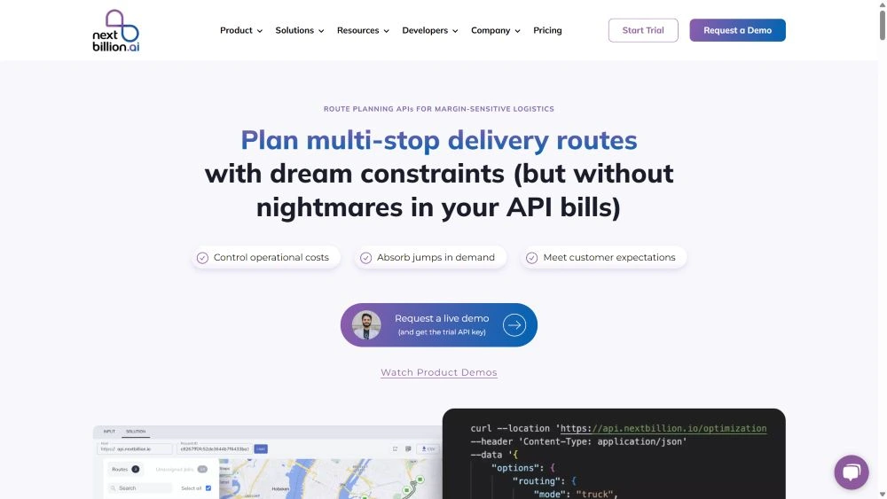
The problem is carefully addressed by a timezone-aware route optimization tool✅, which is an automated route planning system. Logistic companies serving long-distance fleets utilize the software to generate accurate delivery schedules and thus assist the dispatch managers in on-time task completion.
We’ll go further to understand the fundamentals of timezone-aware route optimization and why it is essential in the global logistics market.
Carriers cannot ignore the phenomenon of time zones around the globe while fulfilling long-distance delivery tasks. The above is just one example of a timezone-aware logistics problem. But shipments between two continents, like Washington, DC (UTC-5), and Sydney (UTC+11), face huge challenges in transportation. The timings are not calibrated into a single piece of information.
A flight that departs from Sydney at 10:00 AM on 1st January will arrive at Washington, DC, at around 2:00 PM on 1st January. While the flight takes 20 hours to cover the distance, it appears to have taken only 4 hours. On the flip side, a flight departing from Washington, DC, at 10:00 AM on 1st January will arrive at Sydney at 10:00 PM on 2nd January. Now it appears to have taken almost 40 hours, but factually it is the same 20 hours.
The complexities of time zones deeply impact the global logistics market, leading to disproportionate delivery schedules. The route plans for delivery tasks are generated after considering multiple constraints like customer preference, delivery slots, timings, inventory space, available resources, etc.
 However, one of the major challenges for dispatch managers is tracking Universal Time Coordinates (UTC) while ensuring efficient route plans for delivery scheduling in different regions.
It has a significant impact on the entire lifecycle of logistics management and task completion.
Read how AI reduces last mile delivery costs.
Courier and transport companies face a variety of operational, logical, and communication challenges when transporting goods across borders. But the difference between standard time and DST, or Daylight Saving Time, creates numerous issues in efficient business management and customer satisfaction.
Also read: End-to-end delivery route optimization: A complete guide.
❌Official Hours & Calendars: Locally accepted standard time and DST determine the official working hours of a region or country. While crossing borders or serving intercontinental deliveries, the dispatchers often get confused with the traveling dates and actual time of the region. They get stressed in matching the working hours, public holidays, or preferred delivery slots of the clients.
❌Time Coordination: While the time at the main warehouse is 4:00 PM, it can be 7:00 PM or more for the subordinate staff at the dispatch house. The trucks reaching the hub station after 7:00 PM may not get scanned by the department due to the closing hours, and hence they had to wait for the next day’s DST hours. Accurate time calculation enhances work efficiency with staff coordination.
❌Work Shifts: It is evident that company outlets in different regions had to keep the working hours according to the local time zone. Therefore, it is crucial to schedule the reception of goods at the warehouse based on the workers’ availability. Miscalculation of time slots often costs more than the estimated charges, as the truckers had to wait for a long time.
See what it takes to create an inhouse delivery system in 2025.
❌Warehouse Management: Managers face a hectic challenge in managing the fulfillment centers and hub stations, particularly concerning dispatch schedules, supply chains, and available space. The complications increase with timezone-aware logistics when they do not have automated assistance.
❌Tracking Issues: The real-time tracking feature may not serve proper information for deliveries with timezone differences. This occurs because the timestamp does not align with the local time at the delivery address.
❌Supply Chain: The movement of purchased items through multiple substations on the route disrupts the complete supply chain. It happens when the team members are unable to coordinate with unstructured time schedules of the deliveries due to lack of timezone-awareness.
Read all about supply chain route optimization.
❌Avoiding Misinformation: The majority of customers and clients of logistics companies expect them to deliver the goods in the pre-declared time slot. However, because trucks cross multiple time zones, it is difficult to manually schedule deliveries by region and coordinate fleet arrangements according to the local Daylight Saving Time (DST). The mismatched information can lead to raising false expectations of the customers and wasting crucial time in waiting for deliveries or otherwise reaching out beforehand without information.
❌Traffic Restrictions: It is pretty common to have road closures or traffic restrictions in specific areas. Usually, roads near schools or hospitals are restricted for large trucks during a particular time slot. It is essential to have clear details about these rules and accurately incorporate them into the route plans. With changing time zones, it is critical to keep track of the time difference and create transportation routes accordingly.
❌Negative Branding: Unmatched timings in logistics operations lead to task delay and customer dissatisfaction. Time commitment is critical for business ventures working in the transportation sector. If the company consistently fails to deliver on time, it not just demolishes the brand name and credibility, but the overall working structure crashes due to piled jobs.
Many courier companies avoid using advanced tools and software for tackling delivery tasks on long routes that cross borders. Either they fail to implement advanced technology, or they overlook the impact of timezones on their operations. Often, they perceive it is more costly to integrate automation than to apply manual efforts.
But eventually these organizations end up spending more time and energy in understanding the database from multiple centers to create perfect delivery scheduling by region. Integrating a timezone-aware route optimization API into the system can streamline the whole process while reducing the overall charges with increased work efficiency and brand value.
By now it is clear that transporting goods across different time zones is not just hectic and time-consuming but can create havoc in matching the delivery schedules. Manually creating timetables for drivers is neither feasible nor efficient in reducing costs or total time spent on tasks.
The timezone-aware route optimization serves as the perfect solution for logistics companies. It is a complete process of optimizing the range of routes to be covered by multiple vehicles and moving the products through substations for final delivery at the desired location.
The technology is most effective in mapping the route plans across large geographical areas with more than one time zone. It handles the time-related constraints in the most effective way to calculate feasible and optimized route plans.
Quick tips to hire a delivery driver in 2025.
The timezone-aware route optimization delivers intuitive route plans after considering the local standard time in different regions and incorporating the information with UTC. The system optimizes factors such as delivery time slots, arrival and departure estimations, time windows, and customs clearance to ensure a quick and efficient process.
🟡Task Details: The system sends a request to the route optimization API to generate transportation plans that connect all the regions on the route. It provides details like latitude/longitude for UTC data, vehicle availability, package type and volume, available staff, departure time, and other constraints.
🟡Time Zone Data: The API fetches the UTC data and timestamp to match the accepted time zone and DST in different regions. The purpose is to convert the data accordingly and display the probability of arrival and departure without confusion.
🟡Timezone-Aware Route Optimization: The optimization engine sequences the available information about the stoppages, time windows, which include food, rest, and refueling, traffic structure during specific hours, and changing time zones. It adjusts the movements of delivery vehicles to generate ETAs in the connected regions that fall under the priority hours.
🟡The Route Plan: The tool generates a well-optimized route plan for the delivery agents to transport the orders through multiple channels. They can easily follow the instructions and timelines as directed for movement in different time zones. The drivers don’t need to perform timing analysis or manual conversion.
These fundamental steps outline how the timezone-aware route optimization tool assigns route plans. However, different APIs in this segment may apply additional features, adding UTC details at the starting point, total time calculation, etc.
The technological integration of timezone-aware logistics software into the delivery system encounters multiple advantages for the company and customers.
✨Efficient Working: With accurate information about the delivery vehicle’s arrival, departure, available working time slots in specific regions, and preferred schedules, the team can directly get to work without wasting time on analyzing time zones.
✨Optimum Resource Utilization: You know when to use any particular delivery truck and avoid traffic restrictions in specific hours on the routes falling in different time zones. It arranges the route plans in a way that the warehouses do not get overloaded with pending deliveries, while other substations have empty spaces.
✨Low Cost: Optimized routes reduce excessive fuel consumption, while consecutive movements of the package and automated procedures speed up the delivery schedules. It ultimately creates room for new orders. Timezone-aware route optimization provides information about clear routes with no restrictions and saves the drivers from paying fines on entering regulated areas in zero hours.
✨Customer Satisfaction: Advanced optimization tools provide calculated information about the travelling time and delivery schedules while considering the changes in time zones and DST. This allows managers to provide customers with accurate ETAs, keeping them informed according to their respective timezones. Live tracking creates transparency and ensures when the product can actually reach them. Additionally, fast and timely delivery satisfies the customer with enhanced loyalty toward the brand.
Read: What is vehicle tracking system, and why you need one.
✨24/7 Working: The tool provides correct details about the time zone and DST hours in a region. Companies with operations in different regions can strategically transfer tasks to centers that are just starting their day, taking advantage of the time zone difference. It is the best utilization of timezone-aware logistics.
✨Company’s Credibility: By keeping the customers well-informed about the delivery dates and finishing the task on time without acquiring any sort of transportation troubles, you as a logistics company manage to create a lasting impression in the global. Reliability and transparency in services enhance the brand value.
Organizations that are spanning a global market and transporting products to different regions should always consider integrating timezone-aware route optimization solution. Such industries can be grouped into various sectors to understand the potential of timezone-aware logistics in business enhancement.
🟢Shipment Companies: Long-haul carriers, courier companies, third-party or white-glove delivery service providers, or brands directly exporting their products should leverage the technology for creating delivery schedules by region.
🟢Field Services: Technicians, mechanics, healthcare providers, and other business firms with field work can benefit from the tool if they have to assign tasks that cross regional borders.
🟢On-demand Delivery: Many online grocery, food stores, medical equipment, and such other businesses serve interstate deliveries within a few hours or a day. The timezone-aware logistics technology can assist them in deducing accurate delivery times and inform the buyers about the delivery schedules by region.
🟢Suppliers: Supply chain companies partnered with product manufacturers had to regularly transport food, crops, machines, medicines, electronics, furniture, and all other types of goods. Long-distance transportation requires accurate information about the time zone to match the delivery schedule by region. It is best to integrate route optimization API based on timezone-awareness.
The same way other transporters with interregional deliveries can leverage the benefits of the timezone-aware logistics technology.
Check out how grocery delivery companies optimize route operations with geofencing.
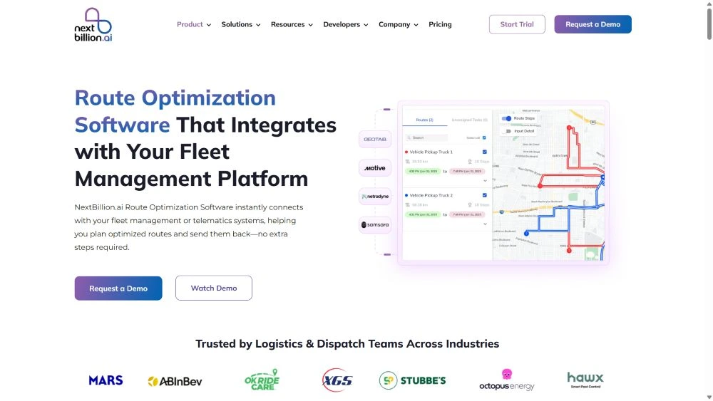
NextBillion.ai is now a world-class AI-enabled platform that constructively handles location-based queries for logistics and transportation of all kinds. We serve a range of APIs and SDKs to generate optimized route plans for dispatchers, navigation facilities for drivers, and live tracking facilities for customers, along with other notable features. 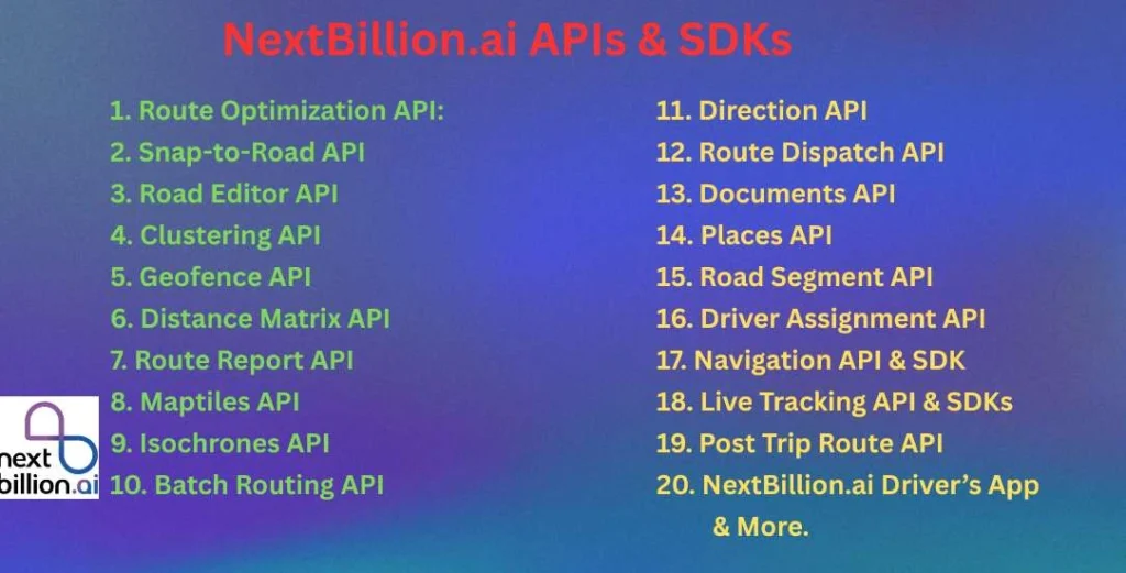
It supports all the ERP, CRM, or telematics systems for quick integrations. Our AI-powered tools can derive significant results for timezone-aware route optimization.
Transportation primarily requires a system that interprets the location of stoppages on the map and creates a traveling route for the delivery vehicles. The route optimization API serves as the optimum solution in finding the most efficient route plan. It saves time and unnecessary fuel consumption due to traffic, diversions, repetitions, etc.
✔️Essential constraints like vehicle type, product category, and size, along with road restrictions during specific time slots, traffic, and delivery points, are prioritized.
✔️It is capable of analyzing real-time data about traffic or weather conditions and deriving plans according to the local dates and times.
✔️Both managers and drivers can readjust the route plans while the task is active.
✔️Courier services can add any number of parcel deliveries as per the vehicle’s capacity, and they will create the most feasible route plan for deliveries while considering the necessary factors like priorities or time windows.
✔️NextBillion route optimization API works effectively in considering critical details about vehicles, time zones, road networks, or priorities, and delivers the best possible output.
✔️For clear details about expenses, you can generate reports on key metrics on fuel usage, staff shifts, vehicle services, etc.
✔️The delivery schedule in any specific region is scheduled according to the local timezone.
It analyzes old GPS data to filter new routes and readjust with the existing network. While it explores the GPS coordinates for movement possibilities, the users can extract a better routing experience from the tool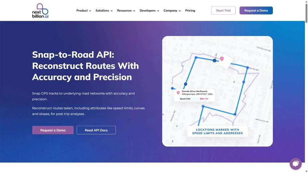
✔️Many supply chain companies use the Snap-to-Road API for evaluating the performance of the drivers and vehicles on specific road networks.
✔️It refreshes the old data with validated information about newly formed routes to access the locations in different regions.
✔️It captures GPS data according to the routes taken by delivery trucks for better assessment in future tasks.
✔️The tool provides a complete report about the journey taken by the packages. You get details about stoppages, traffic violations, total time, etc.
The Road Editor API allows editing the route plans to add traffic details, speed limits, halt stations, schools, food courts, etc.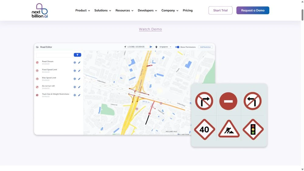
✔️Managers and other users can edit the existing routes to make them more accessible and insightful for the drivers.
✔️For timezone-aware logistics, you can get accurate information related to road closure, restrictions, new additions, etc. to ensure that the delivery agents reach the location on time.
It is an important tool that creates a bunch of orders that have delivery in any particular area and how close or far these places are from a certain base or from each other. Clustering API is suitable for fulfilling large sets of deliveries in a single assignment.
✔️Based on the available data, like delivery locations, food stoppages, re-fueling stations, etc., the tool can quickly pinpoint the central spot among the clusters. It increases the efficiency of the route plan.
✔️You can specify requirements such as the radius from a central point, length of clusters, or the number of orders.
✔️Clustering data helps identify the density of an area for insightful analysis.
✔️Grouping of tasks helps drivers take on-the-spot decisions regarding parking, waiting time, lunch, etc.
✔️The feature allows managers to assign a suitable number of tasks during daylight saving time (DST) hours, taking into account delivery scheduling by region.
✔️By analyzing the density of orders, the logistics companies can establish hub stations in the nearby area, which can help in dealing with timezone-aware logistics problems.
Geofence API creates a virtual boundary for the delivery vehicles, and the drivers or agents can access the details through the digital map on the mobile app. Timezone-aware logistics require careful consideration of routes and segregating the tasks for quick completion.
Read what is geofencing, its application, and components.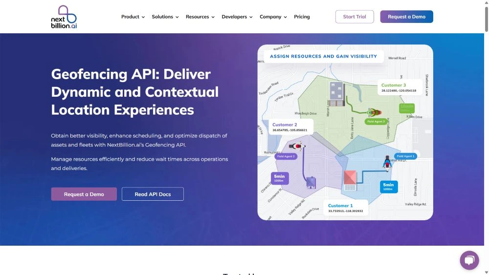
✔️Create fences of any shape and size to allot tasks and delivery scheduling by region.
✔️Managers can enable notifications whenever a vehicle crosses the designated area.
✔️The isochrones and isodistances evaluate the total travelling distance with the approximate time required to finish a certain number of tasks. It helps create successful fences and equally divide the delivery assignments among the drivers.
✔️You can alternatively create a virtual fence around the office or warehouse to receive alerts when unknown vehicles enter the premises.
✔️The system can automatically assign the task to the nearest vehicles in the region, and at the same time, alert the receiver about the pickup or delivery status.
Practical use cases of geofencing in reducing fuel costs.
The Distance Matrix API enables calculating distance and time between multiple locations of the delivery or pickup tasks. It is fast and accurate while working on real-time data.
✔️The large 5000X5000 matrix size allows adding thousands of stoppages to create route plans. It specifically benefits timezone-aware logistics when global brands need to fulfill supply chain demand from around the world.
✔️Irrespective of the data size, it can quickly evaluate the perfect route plan for the delivery agents.
✔️You can calculate average fuel consumption on the route for different vehicles.
✔️Add multiple vehicles on a long route plan to finish the task and calculate the expenses.
Best 5 Distance Matrix API in 2025.
The dispatch managers can extract route reports on different parameters to analyze the complexities faced by the drivers and how they can revamp the new routes to avoid the troubles. Logistics companies providing long-haul trucks to different regions had to choose the most optimum routes. This approach aims to ensure seamless deliveries within the designated DST hours or preferred time.
✔️Edit the routes on the basis of analytical reports and achieve efficient delivery targets.
✔️Analyze the weak points in delivery scheduling based on time zones and develop a more effective strategy for task completion that will increase profitability.
Maptiles API is the grouping of pictures in the form of pixel grids. As you zoom in to expand the image, the targeted region forms clarity with increased size without disturbing the image quality.
Read: What is map tile and how it works?
The static images of the map are combined with vector tiles, which are geometric lines or points to describe road names or locations, and raster tiles are pixel images in grid format.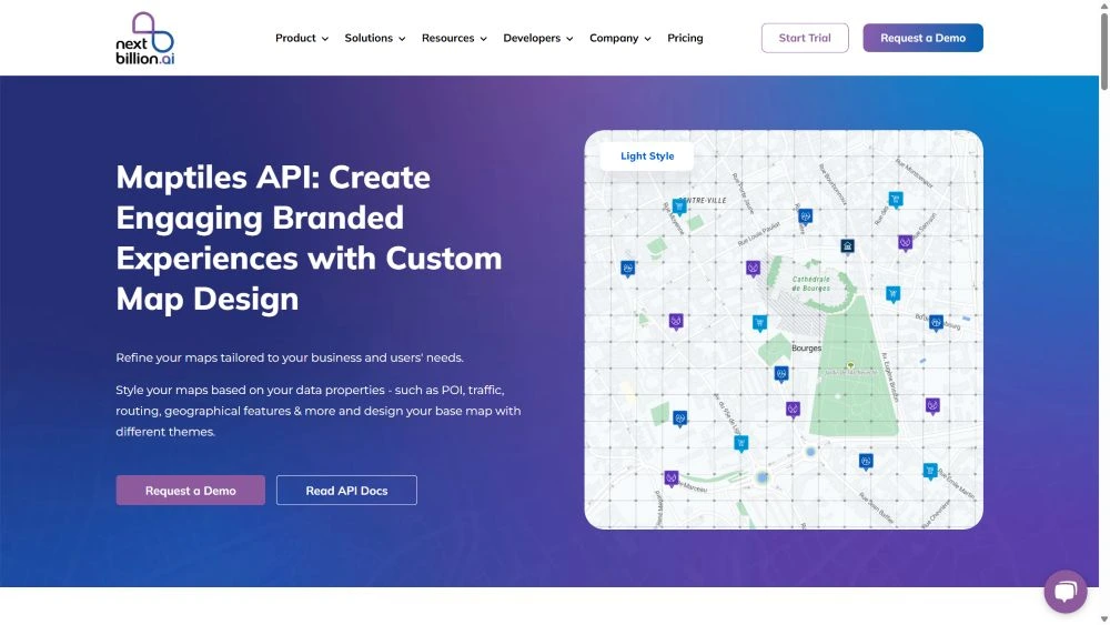
✔️It enables the users to create image tiles of map locations that have complex direction or identification to help the drivers whenever needed.
✔️The tool integrates with the main application, website, or business application, allowing drivers to access the images in offline mode. This feature is particularly beneficial for deliveries in remote regions with minimal connectivity.
✔️Customize the Maptiles with unique themes, add names, or highlight specific features or important landmarks on the map.
✔️These are lightweight images as compared to the real-time map data and easily serve the purpose.
✔️This feature is suitable for displaying geofences in a region, helping drivers understand their limits
It virtually displays the details on the map showing the route plan. The purpose of Isochrones API is to help the drivers understand multiple routes to the delivery points and select the most feasible path.
✔️The visual display uses contour lines to enhance interpretation.
✔️Generate time duration to reach different locations on the map depending upon the mode of traveling.
✔️Drivers can easily locate essential stoppages like food corners, fuel stations, service centers, and even schools and hospitals to stay more careful.
Managers assigning tasks to multiple agents require a batch routing mechanism. It generates specific route plans for all the pickup and drop locations at once.
✔️It saves a significant amount of time by assigning tasks and dispatching trucks within the scheduled timeframe.
✔️Add a wide range of databases, and without any hassle, it will assist with routing.
Also read: Complete guide on Distance Matrix vs Direction Matrix API.
It is a smart segment of the route optimization API that helps in determining the distance between two specific points. It calculates the distance and traveling time based on real-time situations.
✔️Determine the best route for transporters to optimize task allotment and feasibility.
✔️You can add or remove tasks such as product cancellation pickups, depending upon the availability of working hours.
✔️The managers can also preschedule the deliveries considering specific route restriction hours in a particular timezone.
✔️Calculate vehicle-based and time-based routing, whichever suits the job.
Read why you should consider migrating from Google Maps platform to NextBillion.ai Distance and Direction Matrix.
Route Dispatch API enables the managers to generate and share optimized route plans with the delivery agents for execution of the delivery task. There are significant challenges in dispatching route plans related to real-time updates, driver’s safety, or customer satisfaction. But this API creates the best and most feasible output.
✔️The application allows drivers to receive the new or edited dispatch plan from anywhere on their mobile devices, ensuring connectivity.
✔️Send as many route plans as you like, and the application will always maintain a record of them.
✔️Managers can import delivery or pickup data in CSV or Excel format.
✔️Interestingly, this AI-enabled tool is programmed for skill-based routing. It tracks the vehicle’s capacity, load type, and driver’s skill before listing their availability for a specific route.
✔️In timezone-aware logistics, there is a lack of sufficient staffing for regular roles, and the route dispatch API provides immense help in interregional deliveries.
Read how essential it is to optimize load on delivery vehicles.
It adds up with the delivery app as a document form to undertake delivery confirmation or bills by the clients or customers instantly in a digital format after receiving the order.
✔️Create multiple fields on the document, such as name, time of receiving, package type, etc.
✔️Create different sets of forms with some mandatory fields, and add the form to specific routes for driver’s access.
✔️For deliveries scheduled by region, these digital forms are the easiest way to share information about task completion, and not just the hub station but the main server records the details.
It uses the geocoding technique to generate coordinates and other useful information about a location. It converts addresses into coordinates or, in reverse, coordinates into valid postal addresses. The multi-geocode technology extracts information from multiple sources for authenticity.
✔️With optimized route plans, managers can utilize the tool to gather detailed information about the area they need to cover.
✔️You can input 100 queries at once using the batch geocode option.
✔️The structured geocode elaborates on the places around the set location.
✔️It is capable of finding details of unknown places with general identifiers and filters.
It helps extract road network details of any particular route traveled by delivery vehicles, irrespective of the geographical region.
✔️Critical data like coordinates, road type, length, breadth, and lanes, along with traffic restrictions and speed limits, are comprised. You can mark a small section in the zone to gather details.
✔️It also enables editing the existing data in the database with new and corrected information.
✔️The information is critical for calculating average fuel consumption or ETAs and identifying new and improved routes to cover the locations.
Driver Assignment API is designed for dispatch managers to assist them in finding the most suitable drivers based on their skills and experience, analyzing previous data related to the drivers and their task completion records.us data related to the drivers and their credits in task completion.
✔️For timezone-aware route optimization, it is critical to know which drivers can successfully finish the deliveries in a specific region. Hence, this API is the solution.
✔️It offers multiple cost models that are time-based, distance-based, or straight-line calculations.
✔️Refine drivers based on multiple constraints like total time covered or experience with certain vehicle types, and consecutively assign tasks as they finish the trips.
Route optimization involves more than just creating route plans and making connections between the stoppages. Our tool provides a complete navigation system for the drivers and guides them to conveniently fulfill the delivery scheduling by time zone.
We offer both API and SDK so that developers can either enable the app for navigation or create a user-interactive application on iOS or Android platforms.
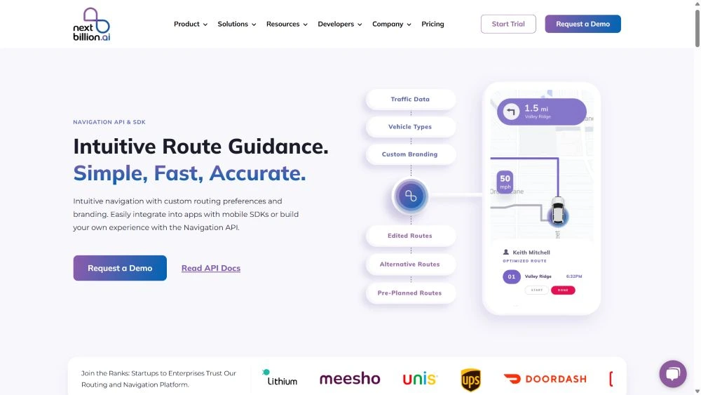
✔️In an unknown region, our tool will assist drivers in reaching all the locations in sequence.
✔️It connects real-time data and provides accurate details about the route and hindrances.
✔️The tool is fast and flexible in deriving navigational routes on the basis of multiple constraints like vehicle type, limited time, etc. This enables timezone-aware logistics companies to calculate the best routes for completing tasks in a short time frame.
✔️The text or voice assistant directs the drivers turn-by-turn to swiftly spot the place.
✔️Its personalized mapping system facilitates editing the map features and adding extra details like restrictions, goods categories, vehicles, staff shifts, etc.
List of best 10 Navigation APIs and SDKs in 2025
Our software utilizes GPS data to create a live tracking environment on the mobile phone. The accuracy level is highest with up to 1 m precision. You can personalize the feature using the SDK file and keep a watch on your drivers’ movements on the route.
![]()
✔️Customers receive delivery information and do not need to make inquiry calls to the customer care desk.
✔️On long-route deliveries, especially when crossing time zones, the live tracking feature is a boon for the managers and clients. It keeps you at ease, and during an emergency situation, they can be quickly reached for help.
✔️It regularly sends alert messages about the last point, route change, traffic law violation, timezone change, etc.
✔️Border areas usually have low connectivity, and that’s where the tool shows its power by showing tracking details while working offline.
✔️The search option lets you analyze insights from the past week’s tracking details.
It is a helpful solution for timezone-aware logistics as it helps analyze the route taken by the vehicles. It is suitable for finding out the reason for any issues that occurred during the deliveries.
✔️Route comparison helps determine the advantages or disadvantages of altering the route from the given plan after the trip.
✔️The insights help figure out the critical points that led to the route change at a certain spot.
✔️Generate a response for any specific factor to create a report analysis.
NextBillion.ai offers the Driver’s App complimentarily with the route optimization API. Drivers can use the tool to get delivery details and navigate to the location.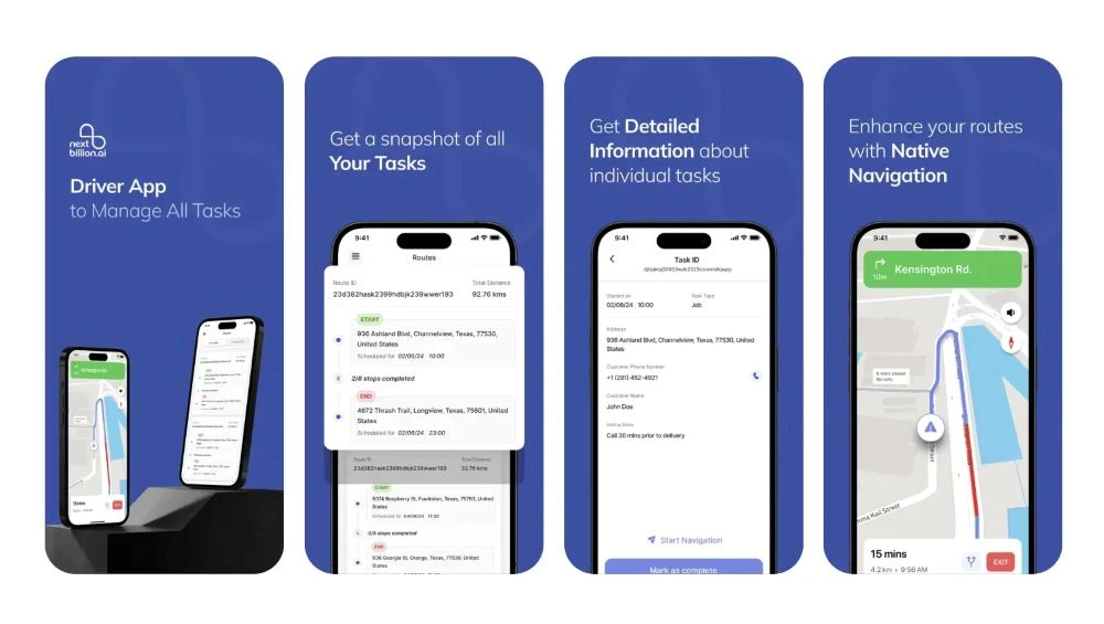
✔️It can successfully integrate with telematics or ERP systems and is highly suitable for field services.
✔️It is a full-fledged application that enhances the efficiency of delivery tasks for timezone-aware logistics, as it keeps the drivers informed about the actual delivery schedules by region.
✔️Drivers can instantly generate proof of delivery forms, which package receivers can digitally sign for confirmation.
Also Read: List of the 5 best route planner apps for Android in 2025.