Table of Contents
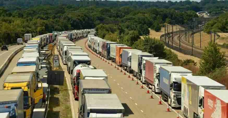
The world is interconnected not only through telecommunication, but also through easy mobility to every corner of the globe. But the dwellers need facilities with mutual growth, and the supply chain system plays a vital role in bridging the gap.
Hence, manufacturers and raw producers connect with shipment firms for transporting the products at multiple levels. Now it is critical to map the travel route for the delivery vehicles, which usually move to several delivery spots and end customers.
Thus, generating the most suitable travel directions for delivery vehicles after considering the stoppages between the supplier and the consumers is termed supply chain route optimization. Factors such as time windows, traffic, load, drop location, etc., are considered in finding the fastest and most cost-effective route through an automated mechanism.
Read how white glove delivery service can amplify your supply chain business. 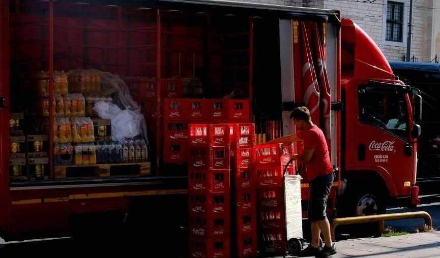
Route optimization is a complex process if done manually. Individuals may spend hours analyzing stoppages, restrictions, time windows, and other factors to decide suitable transits. It is hectic and highly disadvantageous for companies to rely on human intellects for managing supply chains.
Transport companies partnering in the supply chain are now integrating smart technological tools to generate optimized route plans. Route optimization software uses multiple parameters to store delivery details. It includes delivery locations, priorities, parcel details, traffic conditions, vehicles, and other such specifics.
Supply chain strictly depends on transportation, and managing it can successfully reflect the advantages in multiple aspects.
⭐Cost-effective: A notable benefit of route optimization is saving on cost expenditures. It primarily saves fuel costs. The drivers get a predetermined route and don’t have to choose the best roads to the drop stations. It also puts forward the vehicle maintenance schedules, as less traveling keeps them maintained for the long run.
⭐Work efficiency: Instead of pouring loads of work on the drivers, the managers can systematically assign tasks to be fulfilled within a stipulated timeframe. The route automation significantly improves the driver’s experience by keeping the journey stress-free. The drivers can efficiently finish the delivery task and do not need to work overtime.
⭐Quick response: With supply chain route optimization, it is possible to furnish the deliveries at the scheduled time as estimated by the automated system. As a result, logistics companies can handle more deliveries along the route. Their success in turn maintains trust, and customers feel satisfied with perfect ETAs, or estimated times of arrival.
⭐Environment friendly: Efficient movements on optimized routes ensure less fuel consumption. The policy constructively contributes to low carbon footprints by the logistics company and the partners.
⭐Data insights: The system records the traveling data and provides useful insights about the performance of the vehicle, the driver’s abilities, the routes, the delivery times, etc.
⭐Delivery tracking: The managers can track the delivery trucks in real-time. It helps in giving instructions or assistance and alerts them if they de-track from the route in the middle of the journey.
Optimizing delivery routes for the supply chain requires managing various parameters to successfully implement the whole process. The fundamental procedures significantly impact the solutions.
🔶Route details: The traveling route indeed is the primary component in transiting goods for managing the supply chain. It is imperative to have complete details about the stoppages, like pickup and drop locations, warehouses, retailers, gas stations, food stalls, tolls, etc., with the exact geo-coordinates.
🔶Package details: Weight and volume of the goods are crucial for allotting appropriate vehicles and skilled drivers for completing the delivery job.
🔶Delivery details: The system requires customers’ details along with delivery locations, priorities, etc. Provide accurate information, as customer satisfaction is necessary while managing the best routes.
🔶Vehicle details: Vehicle data like load capacity, size, fuel consumption, and service information are also to be considered in the process.
🔶Other constraints: The system also considers details like traffic conditions, time windows, speed limits, road specifics, delivery sequences, etc.
🔶Software Integration: The most critical part is to integrate an efficient route optimization tool with the ERP or database management system for handling transportation tasks. Capable software can analyze all the parameters to create route plans that effectively resolve transit issues. It should assist in monitoring the vehicle’s performance and tracking on the route.
NextBillion.ai has a complete range of API & SDK solutions to manage fleets in the supply chain. It quickly generates optimized route plans after considering all the possible factors on the ground.
Read about the relevance of load optimization in delivery vehicles.
NextBillion.ai offers a prominent AI-enabled route optimization software for supply chains.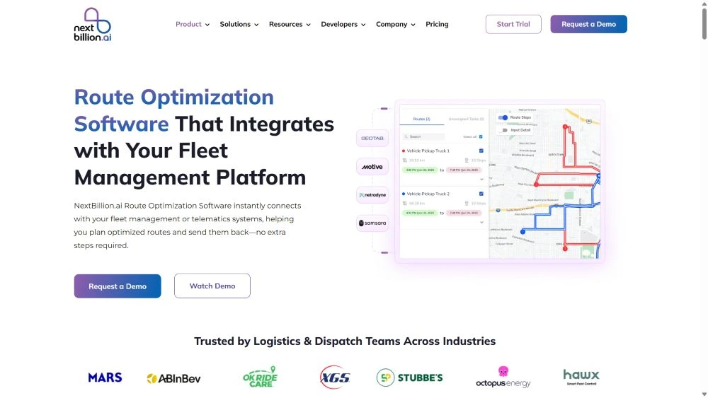
✔️It collects and keeps track of the historical data from different road networks and utilizes machine learning for continuous analysis.
✔️The advanced algorithm fetches all the data from the system for insights. It then creates a route plan that is most feasible for swift vehicle movement considering fuel efficiency, route repetition, or on-time delivery.
✔️It is capable of evaluating the unprecedented issue that a delivery driver may encounter in real time, and thus, giving a foolproof solution.
✔️The delivery managers have the option to monitor the delivery trucks on the route. They can make adjustments for new pickups and drops or change routes for particular requirements.
✔️The NextBillion route optimization tool analyzes all the possible aspects relative to deliveries and transportation. It then devises a travel route that is secure, efficient, and time-bound. Along with advanced AI-enabled tools for technological requirements, our in-house platform—Mapfusion—enhances the mapping capabilities of the logistics service providers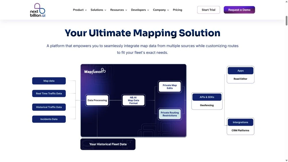
NextBillion is a high-valued software development company working in location technology. We have a robust suite of tools for every mobility-driven business.
With experience and expertise in transit management, our engineers have built advanced AI-powered solutions. Our products cater to the factors that matter the most in supply chain route optimization.
The Route Optimization API is a fundamental product in the logistics industry, assisting shipping companies in determining the most efficient routes and delivery locations. The tool ensures to avoid repetitive or congested routes and calculates the accurate time required to finish the deliveries considering the stoppages and other time windows.
Also read: End-to-end delivery route optimization: A complete guide.
🔵AI-enabled route planning: The advanced algorithms with machine learning techniques analyze the core constraints like vehicle type, load, traffic, road networks, delivery location, or time windows. It then creates optimized routes for the vehicle that are cost- and time efficient.
🔵Live data: The API continuously fetches traffic and weather details along with other instances that can require quick route altercations.
🔵Re-routing function: The API facilitates re-routing while on the journey as many times as required. The drivers can readjust the routes anytime if they suspect any hindrances in the preset navigation.
🔵Multiple stoppages: The API can adapt to manage any number of deliveries by catering to the best possible route after considering all the necessary factors like delivery priorities, ETAs, etc.
🔵Large scale datasets: It has the capacity to handle businesses with hundreds of fleets with a wide network. The tool can effectively manage complex routes and assist in firm commitments to serve on time with the lowest expenditures on travel.
🔵Seamless integration: The API supports all the ERP and database systems and easily integrates to provide optimized routes.
🔵Analytics report: The managers can extract detailed reports on key metrics like fuel consumption, vehicle performance, duties, etc.
🟢Without a doubt it saves expenses on fuel consumption, vehicle maintenance, driver’s overtime payments, and other miscellaneous costs.
🟢It ensures timely deliveries to the customers to retain satisfaction and trust.
🟢The multi-vehicle routing problem in the supply chain is successfully handled with optimal routes for each vehicle continuously and in real-time.
🟢Companies save more with efficient usage of vehicles by utilizing their capacity and picking up goods while returning.
🟢Reduction in fuel usage lowers the carbon footprint of the company and makes the business recognized on the sustainability front.
For large-scale businesses dealing with a bunch of transit orders, the Clustering API is an evident solution. It identifies locations based on their distance from a point or closeness to each other and clusters them for optimization. 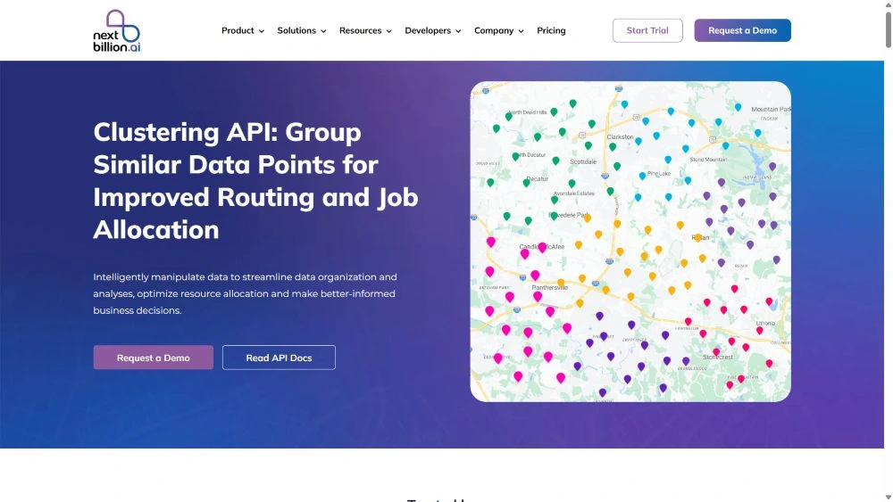
🔵Spatial data: The tool analyzes a set of location coordinates or delivery orders and groups them as per their spatial proximity.
🔵Automated process: The cluster algorithm can automatically identify the central point based on factors like close proximity, feasible routes, or ETAs.
🔵Parameters adjustment: It gives an option to add constraints, such as radius or density of clusters in a group, before generating the required output.
🔵Data analysis: Clustering location data in specific groups helps managers make analysis about the area and delivery options.
🔵Optimize resource allocation: It reduces the traveling distance for delivery trucks, the duration to reach each point, and the cost involved by grouping tasks, services, or deliveries.
🟢Clustering helps in assigning achievable tasks to the delivery agents.
🟢It helps in analyzing demand patterns in specific clusters and forecasting orders for efficiently managing resources and storehouses.
🟢Supply chain companies utilize the clustering API tool for minimizing the stress level of the delivery agents by distributing the tasks equally among the team members.
🟢Clustering identifies customer density zones and helps in establishing warehouses or distributors at suitable locations.
🟢The companies can cluster the locations in multiple groups and utilize route optimization software effectively.
The Directions API is also a part of route optimization and works similarly to the Distance Matrix. However, there is a notable difference between the features of the two products. It actually computes distance and ETAs between two locations instead of multiple points.
🔵Vehicle specific: Compute optimal routes and ETAs depending upon the vehicle type, such as size or load capacity.
🔵Waypoints: You can also add multiple waypoints as coordinates on the route.
🔵Schedule Departure: Pre-schedule the vehicle’s departure on the basis of the best routes and ETAs.
🔵Fast Version: The fast version provides the distance and ETAs in real time.
🔵Flexible Version: It additionally provides vehicle routing and time-based routing function.
🟢With accurate ETAs between two locations, you can add or remove a few waypoints to get higher optimization.
🟢It complements the functions of Data Matrix by offering additional details about the route, instead of just the matrix of information. Hence, supply chain companies choose to integrate them together and leverage the benefits.
Distance Matrix API is an efficient tool for calculating travel time and distances between multiple junctures on the delivery route. It is the fastest and highly accurate in the segment with the capacity to handle a large set of locations.
Also read: 5 best Distance Matrix APIs to try in 2025.
🔵Large matrix size: With a 5000X5000 matrix size, it enables adding thousands of pickup and drop centers along with roadblocks, fuel stations, and other road edits to generate transit distance and ETAs.
🔵Fast and accurate: It takes only a few seconds to evaluate large data for calculating arrival time and the exact stretch between the stoppages.
🔵Vehicle specific computation: A significant benefit is to calculate mileage and transit schedules on each trip which is according to the vehicle type.
🔵Flexible charges: With multiple payment options on API calls, you can opt to pay on a per-call basis, for a bulk order of calls, or for the number of vehicles added.
🟢Capacity to manage thousands of locations at once benefits supply chain businesses to explore more prospects on the route for deliveries.
🟢The customers are more satisfied with receiving the parcels according to accurate delivery schedules.
🟢The Distance Matrix API provides insightful analysis about distance and time delays between specific spots. It is useful to replan the positions of warehouses and distribution centers, or otherwise tasks, to reduce unnecessary costs.
🟢The businesses can test different scenarios of delivery routes, vehicles, and number of locations to estimate ETAs and expenditures before executing a plan.
Integrating the Snap-to-Road API with the system provides a reconstructed route on the given locations with the purpose of data correction. It undertakes the raw GPS coordinates of the delivery spots to find the most prominent road networks nearest to them.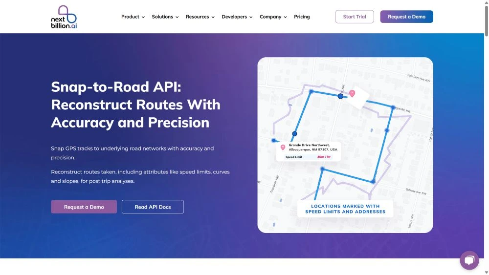
🔵Data analysis: The tool works effectively in analyzing the raw GPS coordinates and allocating them to the nearby road network.
🔵Data cleanup: The purpose is usually to clean up the existing or past data related to the delivery locations by removing the error or unusable data.
🔵Coordinates alignment: It aligns the GPS coordinates with the closest path that is taken by the trucks and provides better representation of the route.
🔵Accurate details: The tools provide accurate information about the driver’s movements on the route, traffic violations, speed, time taken, tolls, stoppages, etc.
🟢Snap-to-Road works as the pre-planning step of route optimization where it synchronizes the random location data with the road for the highest accuracy in distance calculation and ETAs.
🟢Supply chain brands can utilize the tool for tracking vehicles and drivers’ performance on the task.
🟢The tool effectively cleans the GPS data, which is more useful for analysis through telematics.
🟢It reports about the complete journey covered by the delivery agent, whether on vehicle or on foot, and thus helps calculate mileage and reimbursements.
The Isochrones API creates visual details on the map for observing multiple locations with similar distances or travel times from a certain point.
🔵Central location: The managers can define the various central points or driver’s location to evaluate the distance or time for respective locations.
🔵Time durations: The tool ideally calculates a range of time intervals to showcase the equivalent points.
🔵Travelling modes: You may choose your mobility type, like a specific vehicle or walking through the path, and generate isochrone areas for reference.
🔵Data output: The isochrones are generated in polygons or contour lines that are represented on the map.
🟢Supply chain companies can plan deliveries using the Isochrones API by evaluating reachable time frames for specific spots.
🟢It helps allocate resources, like emergency services, food hubs, or fuel stations, for the drivers while planning delivery routes.
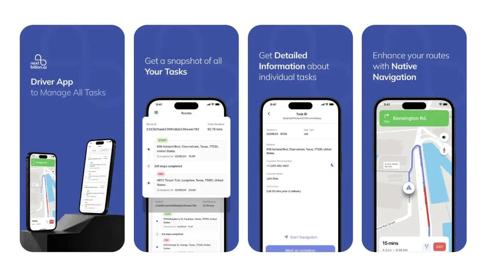
The sole purpose of efficient transportation is to guide the vehicle drivers on a suitable and optimized route for fulfilling deliveries. Hence, it is critical to utilize the functionalities of navigation through our Navigation API & SDK solution.
Developers can start working with the API to experience navigational features on the app or integrate the SDK files for Android or iOS mobile apps to get an intuitive user interface.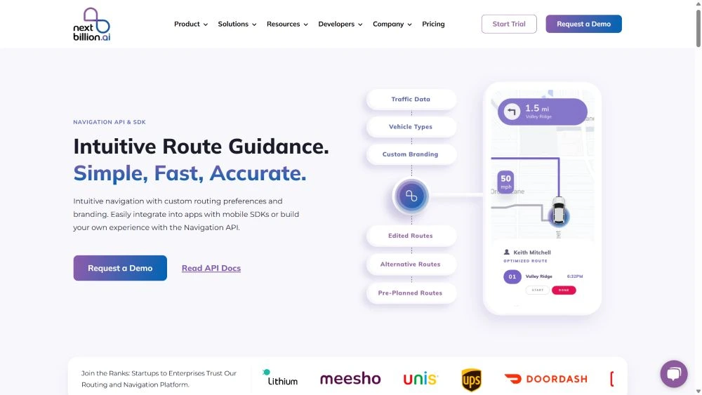
✅Navigation API:
Its purpose is to calculate a suitable directional output with turn-by-turn instructions between two or more stoppage locations. NextBillion offers two versions of the API for specific functions.
💠Navigation Fast API: It is capable of providing navigation details in real time after considering the traffic conditions and other factors.
💠Navigation Flexible API: It is an advanced version with customization facilities for vehicle-specific or time-based solutions, i.e., the fastest or shortest route types.
✅Navigational SDK:
It is available for iOS, Android, and Flutter apps. Developers can build apps with high standards for user interfaces and branding capabilities.
🔵Turn-by-turn directions: Navigate the drivers through textual directions or voice-guided instructions to fulfill the delivery job while ensuring that they follow the most suitable routes.
🔵Real-time traffic details: Provides traffic information in real-time to readjust the routes instantly.
🔵Unique routing plans: It considers all the factors like load type, truck size, distance, traffic, etc., before generating optimized routes. The purpose is to ensure the driver’s safety while handling the load and fulfilling deliveries on time.
🔵Comprehensive map: Fetches map data from multiple sources for accuracy. Supports customized and interactive map formats with an intuitive interface.
🔵Import route plans: You can import preplanned routes for known locations to act accordingly.
🔵Route customization: Add private maps or customizations like road restrictions, street events, etc., with off-road navigation.
🔵Easy Integration: Conveniently integrate advanced features of navigation with the Android, iOS, and Flutter SDK files.
🟢The Navigation tool keeps the supply chain delivery truck on the right track.
🟢It keeps the drivers stress-free as they do not have to recheck road networks on the map.
🟢Intuitive interface with voice guidance facilitates them in maintaining vehicle speed.
🟢The drivers never miss delivery schedules.
The Route Report API provides a detailed report on the completed routes for future analysis and decision-making. It is incredibly helpful in optimizing delivery routes.
🔵Trip-based details: It takes specific routes as input data and generates a complete report about distance covered, total time, speeds in segments, fuel consumption, stoppages, etc.
🔵Counting attributes: You can review the report to analyze the number of tools, tunnels, or bridges on a route.
🔵Route comparison: It is an effective way of comparing different routes.
🟢A prominent benefit of reporting is to utilize them in analyzing the weak points and thus, making suitable changes to enhance efficiency.
🟢Supply chain companies can use the reports to evaluate the performance of the employees.
Batch Routing API simply puts multiple routing requests to generate the output at once. It can handle multiple pickup and drop stations to calculate the perfect route.
🔵Bulk route: It significantly saves a lot of time by generating bulk routes instead of a single API call at once.
🔵Scalability: The tool has the capacity to handle a large volume of databases.
🔵Quick analysis: It takes a few seconds to analyze and generate the output.
🟢Large organizations working in supply chain enable Batch Routing to efficiently plan the routes for the entire fleet.
🟢It works efficiently in dispatching a number of drivers with their route plans.
As the name suggests, the purpose of the Live Tracking API & SDKs is to capture the movements of the delivery vehicles and locate them at any given moment. The users can create assets by giving unique IDs to the vehicles for tracking. It primarily utilizes GPS technology to extract tracking data in real time and transmit it consistently to the network.
![]()
NextBillion facilitates the developers to create app-based solutions by integrating SDK files for Android, iOS, and Flutter tracking with a customized database.
🔵Trigger notification: Monitor the vehicle’s movement and current position while getting alerts on speed limit violations, last location, detracting from the route, moving away or entering the allocated area, and more.
🔵Closest proximity: It is a powerful tracker with an accuracy level of up to 1 meter and works offline as well in low connectivity regions to maintain location history.
🔵Easy integration: Share tracking data back and forth to the ERP systems and conveniently integrate with GPS devices.
🔵Search: Search for all the active assets in an area in real time as well as with historical evidence of 1 week.
🔵Trip specific tracking: You can opt to track particular vehicles while they enter a certain area or reach stoppages that are important. Once the trip ends, the API will send you the entire report.
🔵Share tracking function: Use the Namespaces feature to let your customers track the consignment delivery.
🔵Data visualization: Visualize the asset on a live location by integrating SDK files.
🔵Customization: With SDKs, you can adjust the user interface and data storage location.
🟢Live tracking is critical for supply chain businesses as the retailers, manufacturers, and distributors rely on deliveries for further steps.
🟢 Real-time monitoring keeps the drivers answerable to the delivery delays as every step is reported to the managers.
🟢 Live tracking gives a sense of satisfaction to the customers.
🟢 It saves unnecessary time waste while waiting for delivery because the receivers know when the order is arriving.
🟢 For security purposes, it is imperative to have a tracking system. During emergency situations, the concerned departments can reach out to the exact point of disturbance.
The concept of the Geofence API is about enabling the system to create a virtual fence in an area that is controlled through a digital map. The purpose of the tool may vary from managing a vehicle’s movement to area allotment to the delivery drivers.
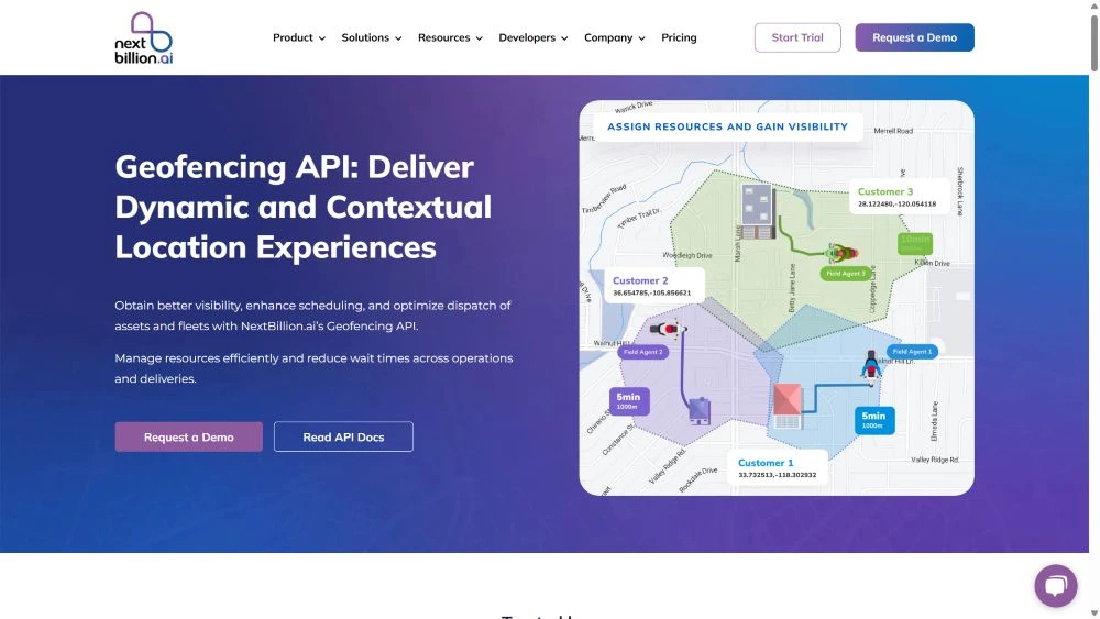
🔵Types of geofences: With this tool, you can create geofences in circle, polygon, or isochrone shapes.
🔵Multiple geofences: Allocate specific areas to each driver in the fleet and monitor them moving accordingly.
🔵Push notification: You may opt to receive textual push notifications on your digital device whenever an asset touches the virtual boundary in the area.
🔵Genuine proximity: Use isochrones or isodistances for evaluating the delivery zones for the drivers, which is based on the total distance to be covered and the time required for movement.
🔵Area security: Create restricted zones and get alerts when unrecognized vehicles enter the area.
🔵Geomarketing: Additionally, you can use the geofencing technology to create sales drive within a geographical area. There are many such use cases applicable depending upon the requirements relative to area targeting.
🔵Hyper-local delivery: The automated system assigns delivery orders to the nearest agents in the zone while notifying receiving ends about the pickup & drop-off status. Check out how grocery delivery companies optimize route operations with geofencing.
🟢Supply chain businesses track the delivery truck entering or exiting the virtually enclosed region around the warehouses.
🟢It is often essential to put away the vehicles from entering restricted areas by the government to avoid penalties. The geofence system alerts the managers as the driver crosses the designated borders.
🟢The retailers receive alerts when the delivery trucks reach a closer proximity.
The Post Trip Route API helps in examining the actual routes taken by the delivery drivers after the transportation task is completed.
🔵Route comparison: Its purpose is to bring out the difference between the planned route and the alterations made in realtime.
🔵Useful insights: You can make an analysis as to why and at which points the alternate paths were taken and whether it benefited or not.
🔵Parameters: It has the option to input waypoints or locations and generate desired results about the trip.
🔵Performance: It helps in analyzing the performance of the drivers in multiple aspects like travel time, guidelines followed, etc.
🟢Supply chain companies utilize the tool to review the losses or gains in different segments or expenditures.
🟢They also review the reports about the drivers, such as their skills and ability to undergo tough situations and fulfill the job.
Route Dispatch API enables sharing or forwarding the optimized route plans to the designated delivery drivers. One can easily understand it as the intermediary step between route optimization and delivery execution.
Read about challenges related to dispatch management.
🔵Quick dispatch: Delivery managers can instantly send the route plans to the driver’s mobile sets or any other navigation device that is linked with a registered email address.
🔵Customization: The dispatch routes are linked to applications for recording proof-of-delivery or navigation instructions.
🔵Easy integration: It seamlessly connects with the telematics system for instantly planning the routes and sending it to drivers.
🔵Data import: You need to import data from the ERP system and upload it in CSV or Excel format.
🔵Skill-based dispatch: It automatically checks for the driver’s skills or the vehicle’s capacity before sending the dispatch routes. You can read more about skill-based routing in route planning and dispatch.
🔵Batch dispatch: The users can send many route plans to the assigned drivers with one click.
🟢With reduced human interference, the tool ensures efficiency in workflow and minimizes errors.
🟢Supply chain companies find it easy to share multiple routes at once without wasting waiting time.
🟢The drivers find it easy to communicate important information to the dispatch managers.
The Documents API is an additional tool for managing form templates that delivery agents can use for saving various documents such as delivery confirmations, bills, etc.
🔵Configure fields: The managers can create desired fields on the panel with specific data types along with data validation rules.
🔵Route addition: You can add the forms on a specific route while dispatching the plans to the drivers.
🔵App compatibility: Delivery agents can access these forms on the Driver app and edit as per requirement.
🟢Document AI is an essential component in supply chain management where delivery agents can generate proof of delivery after task completion.
🟢Verifying documents on the spot ensures compliance with transportation guidelines and parcel details.
🟢It also contributes to sustainability by reducing unnecessary paperwork and streamlining workflows through digital documentation.
Maptiles API technology is interestingly gaining weightage among the field service providers. It is a group of image files of any targeted area or place saved in a grid format and can be visualized as a pyramidal structure, which expands as you zoom in.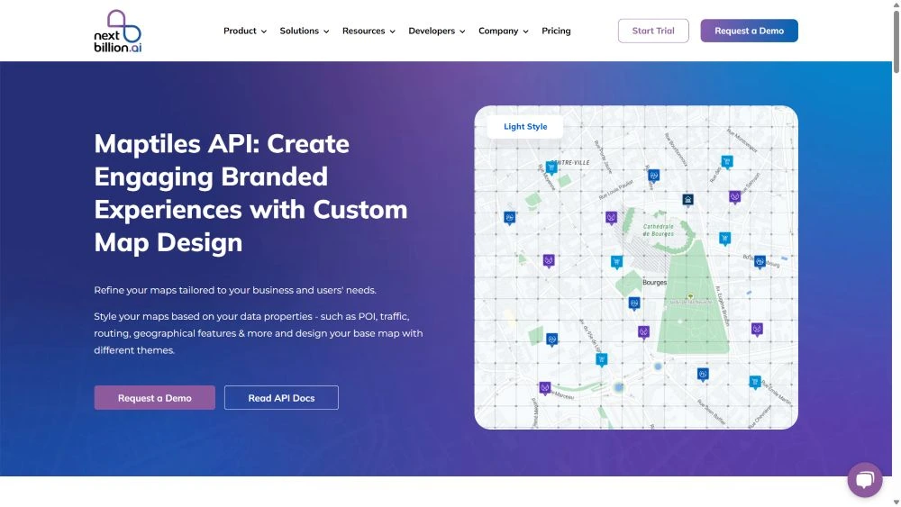
It simply means that as you zoom in on an image, the grid gets subdivided into multiple small grids to display the targeted region without compromising on the display quality.
🔵Maptiles structure: The tool creates a collection of images as tiles at multiple zoom levels and thus prevents the need for displaying real-time map data.
🔵Functionalities: It is a composition of Vector tiles, Raster tiles, and Static images. Vector tiles contain geometric data like road names and places as points or lines. Raster tiles refer to pixel-based data stored in a grid format. Static images are standalone pictures of the maps that are non-interactive.
🔵Quick loading: It effectively manages the need for integrating real-time map data, which takes longer to load during slower internet. The Maptiles minimize bandwidth usage as they load only specific images at a time.
🔵Customizable: NextBillion provides an option to edit the Maptiles appearance on the application, which is suitable for branding and other requirements. You can keep the focus on traffic, POI, geographical features, routing, etc., while applying different themes.
🔵Smooth zooming: These maps are easily integrated into the website, apps, and business software to provide an interactive experience of panning, zooming, or switching map layers.
🔵Highlight landmarks: You can mark important locations on the map that are close to your company’s location. You may also display weather details, track orders, and a lot more.
🔵Visitor engagement: Static maps are lightweight and quickly load on the website to keep the viewers engaged on the page.
🟢Supply chain companies use Maptiles to display optimized routes embedded in the application used by delivery drivers.
🟢Companies integrate the tool with live tracking API to visualize and confirm the routes while monitoring the progress.
🟢The tool is also essential for displaying geofences in a region while monitoring the asset movement.
🟢It assists companies in providing contextual details about the area in which they are located.
🟢Supply chain brands utilize Maptiles for offline navigation and delivery operations in areas with poor internet connectivity.
The Road Segments API generates detailed information about the road networks in any targeted geographical region.
🔵Information specifics: The tool provides details like road coordinates, shapes, types, speed limits, traffic, and restrictions.
🔵Data refinement: You can rectify existing road data with improvised information.
🔵Area marking: It requires marking an area in circles or boxes to fetch required information.
🟢It is useful for supply chain companies to create precise route optimization after considering the gathered details.
🟢Details like speed limits, traffic, etc. help calculate accurate ETAs or fuel consumption.
🟢It helps identify or analyze road networks for future prospects.
The Road Editor API is an effective tool for editing routes for the delivery trucks for a convenient navigation experience. As instructional content, the route planners can add restrictions, turns, or speed limits on particular roads. NextBillion offers the tool with the Enterprise Edition plan.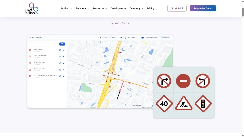
🔵Multiple attributes: It allows managers to modify route transits by making it more practical according to the situation on the ground.
🔵Seamless integration: The tool easily integrates with other route optimization software solutions to complement the services.
🔵Collaborative editing: The tool also allows multiple users with permission to edit the route with personal insights.
🔵Update Data: Often riders face issues on new road construction, but this tool helps to add useful details about roadblocks, turns, etc.
🟢Supply chain management can accurately calculate arrival time since the riders have realistic insights and instructions about their journey.
🟢Large scale businesses find it easy to save the edit input once for particular roads, vehicles, or even for specific days of travelling.
🟢It is highly useful for delivering goods in remote areas where map data is inaccurate. The users can edit the road data correctly to ensure efficient routing.
🟢Use the MapFusion platform to modify map data with the inclusion of specific factors like traffic, road restrictions, industrial zones, etc. that are relevant to the business needs.
Places API is powerful software that can extract detailed information about a location based on different constraints. It provides relevant data about known and unknown places.
🔵Geocoding: Geocoding is the process to convert addresses to coordinates.
🔹Forward geocode: Generates coordinates of known places and areas.
🔹Reverse geocode: Generates a detailed address of the input coordinates.
🔹Geocode postcode: Generates postal code of coordinates.
🔹Structured geocode: Finds places around a location address.
🔹Batch geocode: Finds multiple places for up to 100 search queries.
🔹Multi geocode: Finds coordinates and addresses from multiple sources and updates the information output.
🔵Place Lookup: Finds places with unique identifiers and returns complete postal addresses.
🔵Autosuggestion: Assists users with autosuggest or autocomplete queries.
🔵Search Places: Finds unknown places using filters and free-form queries.
🟢It helps commendably to the supply chain managers by finding accurate location details.
🟢The users can also fetch information about the connecting region and utilize it for future prospects or route optimization.
Our API and SDK solutions are scalable and customizable as per the business requirements and thus perfect for managing supply chain route optimization.
Using route planner apps for delivery agents is vital for logistics and transportation services. Here is a list of the 5 best route planner apps for Android in 2025.