free Route Analysis
00 Days
00 Hours
00 Minutes
00 Seconds
Claim Now
×
Avoid Highways vs Avoid Tolls: How Routing Algorithms Actually Decide

Avoid Highways vs Avoid Tolls: How Routing Algorithms Actually Decide

Published: March 18, 2026

Logistics companies apply the formal procedure of adding constraints such as “avoid highways” or “avoid tolls” for delivery vehicles scheduled on a transportation task. The instructions trigger a set of algorithmic decisions at the backend of the routing tool. The routing algorithms are designed to navigate the vehicle in an efficient, compliant, and feasible direction towards the destination.

What appears as a simplistic action on the dashboard holds complex algorithmic structures that optimize paths through massive road networks while following multiple constraints. 

Dijkstra’s or the A* algorithm can find the shortest path while considering the added constraints. But avoiding highways vs. avoiding tolls poses a separate implication on the route. It is because traveling through highways may take more time for delivery, while toll roads may increase the overall transportation costs. On the contrary, there are scenarios when tolls or highways cannot be avoided, and hence, the routing tools cannot apply “no route” for avoiding constraints. 

So how do the routing algorithms work? Can they actually decide between avoiding the highways or tolls? What is the algorithmic structure of a powerful routing system?

These are some of the questions that we are going to explore and also deduce the capability of standard Route Optimization API tools.

highway and toll routes

How Do the Routing Algorithms Work?

Route optimization is an essential feature of navigation systems, which delivers the most feasible path for the transporters to move from origin to destination. It is a consolidated procedure of factoring out distance, time, compliances, and various other constraints for deciding the most preferable transit route that fulfills the objective of transportation. 

Hence, generating an efficient route does not directly apply the logic of shortest distance or fastest movement between the two spots. The route optimization API has to consider the live traffic data, weather conditions, road regulations, highways, tolls, fuel consumption, time windows, SLA penalties, etc. 

The routing algorithms manage these complex calculations to deliver effective solutions. 

What are the elements of route optimization?

The route map is projected as a graph with nodes and edges, where:

  • Nodes represent the delivery locations, warehouses, etc.
  • Edges represent the road network
  • The constraints are added as Weights on the edges

What is a weighted graph?

Weights have critical significance in routing. These are defined as a cost function on the edges, intelligently assigned by the algorithms to call back the most efficient route. Time windows, gas stations, or restricted roads are unavoidable, while “avoid tolls” or “avoid highways” can be added as hard or soft constraints.  

For example, the shortest distance or length of roads is added with minimal costs as weights. Time to travel a road holds a calculation based on a mathematical formula. But in practical terms travelling time varies depending upon the traffic conditions, vehicle type, load, average speed, etc. 

Similarly, fuel consumption has weights that can vary due to congestion and low speed, and vehicle type or load category also impacts the routes. 

Tolls are weighted with additional numbers as toll fees, and when complete denial is requested, the algorithm puts an infinite value as weight against the tolls.

In the same way, hard constraints to avoid highways will fetch infinite value on the edge, while for soft constraints, it may have a small penalty, which signals the algorithms to opt only if movement through alternate routes is more expensive.

The weights are dynamically updated in real-time with traffic data, weather, roadblocks, etc. 

The general formula for total cost becomes:-

Total Cost = Distance + α(Time) + β(Fuel) + γ(Penalties)

Also read: how to reduce last mile delivery costs using AI technology?

routing algorithms

Why does the system require accurate transit goals?

The food delivery chains or emergency services require the fastest routes, while courier services opt for the shortest and most efficient routes. Similarly, low fuel consumption, maximum deliveries, compliant routes, or other such objectives can be defined. 

The delivery fleets need to minimize the travelling charges, while ride-hailing drivers want to avoid toll disputes. On the other hand, EV drivers prefer toll routes over outskirts highways to preserve their traveling range and charging facilities.

What is the role of algorithms in optimizing the routes?

Depending upon the assignment conditions, routing algorithms get activated.

  • The Dijkstra or A* algorithm calculates the lowest cost for the shortest distance with a single destination.

  • The Traveling Salesman Problem, or TSP, resolves complex tasks with one vehicle and multiple stoppages.

  • The Vehicle Routing Problem, or VRP, handles multiple vehicles and stoppages with carrying capacity, driver shifts, and other such constraints. Some routing solutions facilitate load optimization in delivery vehicles.

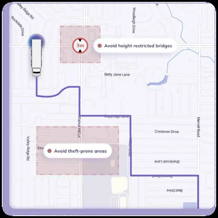
To figure it out in brief, the route optimization API does not guarantee to avoid highways or tolls if an alternate route does not exist. Instead, the cost function creates a preference for the modifiers depending upon the requirements.

Why Does it Matter When You Select “Avoid Highways”?

Highways are structural constraints in route management and have the highest preference in the optimized route plans. By requesting the optimization engine to avoid highways, you tend to change the fundamental design of the algorithm, which primarily cares about speed, time, and access control. 

Highways are different from ordinary roads because:

  • High Speed: It is assumed that the average speed of vehicles on these road networks is higher. 

  • Greater Capacity: With minimal interruption of traffic and the capacity to move high volumes of vehicles, transit through highways generates stable ETAs.

  • Access Control: These roads have access control with limited entry and exit points, which reduces delay in reaching the destination.

Also read: What is ETA and ETD? Do they impact routing in logistics and transportation?

What is function road control, or FRC?

Different road segments are tagged with functional road class, or FRC, on a digital map. Highways, expressways, motorways, primary/arterial roads, collectors, local streets, etc. are the types of segments in road networks classified sequentially considering their efficacy for transportation.

The most suitable highway is weighted as FRC0, followed by another road as FRC1. Highways are the top priority of the optimization engine for API calls that require the fastest or shortest routes for local deliveries or have no critical regulatory issues. In-house delivery trucks often choose alternates to avoid compliance issues. 

For soft constraints, the highway segments are penalized with higher costs along with the travel time. Now the engine will opt for them only when the alternates are either unavailable or are inefficient with much higher travel time.

For hard constraints, the highway segments, or the edges, are entirely banned for the routing algorithms.

How does “Avoid Highway” impact routing?

When you choose to avoid highways, the algorithms penalize the selected edges with a higher cost function. This would instantly increase the distance, which raises the ETA calculations because the route loses high-speed stretches, and vehicles face more intersections, signals, turns, etc., that delay the trip. It would eventually increase the total hours, shifts, fuel consumption, and total expense.

Why Does it Matter When You Select “Avoid Tolls”?

Tolls are charges paid for travelling through a particular road segment, bridge, or tunnel, which are generally based on the distance and vehicle type. Algorithms are trained to cut the travelling costs, which is a considerable factor in optimizing routes.

So “avoid tolls” actually signals the system to treat money constraint as the top priority in fetching a path towards the destination and keep travelling time or journey distance as secondary parameters.

As a matter of fact, toll routes often impose compliance issues on the delivery vehicles, and often long-haul trucks or other transport services prefer alternate routes.

Also read: Why timezone-aware route optimization matters for global logistics?

How are toll segments tagged in map data?

In simple terms, toll roads are weighted as an additional fee along with the traveling time and distance penalty. So when the API generates a request to avoid tolls, the system perceives it with reducing the travelling expense (until a hard constraint is opted for.) 

The algorithms add extra weight to these edges on the graph along with the toll road fees. While generating the route plan, the tool will remember to avoid these road segments and consider cost factors first, treating time, distance, fuel, or other factors as secondary. 

As a practical scenario, the requested route plan may have extra turns and traffic congestion. The overall charges may get reduced depending upon the toll charges and increased distance. Hence, the decision to exclude tolls is not necessarily due to the cost factor. There can be other factors like restrictions/penalties for overloaded vehicles, furnishing waste collection, snow plowing, and other field services that may need to exclude toll roads. 

The soft constraints are weighted to avoid the tolls and choose alternatives until the avoidance becomes impossible or non-feasible.

The hard constraint or complete exclusion will only opt for the toll-free routes or abort routing when alternates are practically impossible.

How does “Avoid Tolls” impact routing?

Avoiding tolls is more of an economic constraint than a structural constraint. In practical terms, bridges, tunnels, mountain passes, or other freeway regions with toll segments are often unavoidable when the delivery schedules are lined up. The system would either pick the least tolled route or compromise the avoid toll option in situations when other routes are extremely absurd. This makes toll avoidance a multi-objective optimization problem, not a structural rewrite.

How Are Avoiding Highways and Avoiding Tolls Different?

Highways and tolls have specific significance in route management. Routing algorithms are programmed to calibrate the weight of each segment and generate a route that efficiently fulfills the delivery task. 

Why are highways and tolls advantageous for route optimization?

Highways and tolls have direct significance to route optimization concepts and primary objectives.

  • Highways are considered fuel-efficient routes for the logistics vehicles. These road segments directly pass through the towns with fewer intersections, and multiple lanes let the vehicles move at a steady speed. No unnecessary acceleration, brakes, or gear changes saves fuel consumption, even more than shortcuts across the city streets.

  • Vehicles face fewer maintenance issues on highways. Delivery trucks riding through local streets, which are often less maintained, can face tire punctures, broken axles, and other troubles.

  • Toll roads allow bypassing towns, bridging rivers, or tunneling the hills. It typically cuts short the travelling time for the vehicles, which can be scheduled to handle extra orders in the same shift.

  • Along with maintenance issues, moving through urban streets increases the potential risk of accidents or minor clashes.

How is avoiding highways and tolls advantageous?

When companies attempt to avoid highways or tolls, it is obvious that the optimization constraint is dependent on variable factors rather than cost, time, or speed.

Driving on highways requires expertise about speed consistency, lane-changing rules, and other essential skills. Experienced drivers can smoothly transit through this road segment. But companies that lack skilled drivers due to shift issues can choose to avoid highways and prefer safe and steady transportation.

Toll roads are costly for logistics, as they add transportation charges. It can be carefully calculated by routing algorithms if choosing alternate routes that also increase the traveling distance is feasible in terms of overall fuel consumption and task completion.

Another considerable factor is that logistics companies often tend to avoid highways and tolls due to the compliance issues. Certain delivery vehicles are not permitted by the transport departments to move through specific road segments. It may be because of the vehicle’s size or the category of items loaded over it. In such cases, the optimization criteria are not about time or cost, but regulations. Thus, these road segments are deliberately removed from the edges.

Often tolls exist on the highways too, and so they may get avoided with interchangeable constraints to manage transit charges or avoid restrictions. 

There are different consequences faced by the delivery managers when they turn to avoid highways or toll roads.

Avoid Highways vs. Avoid Tolls

Parameters

Avoid Highways

Avoid Tolls

Optimization perspective 

Structural constraint

Economical constraint

Routing impact

Unstable ETAs, complex transportation, slow movement

Longer routes, excess fuel consumption, turns and intersections

Graph analysis

High-speed network penalized

Connecting bypasses penalized

Who benefits

Food, grocery, local couriers, last-mile delivery

Long-haul trucks, passenger vehicles, intercity transport

Reasons to avoid

Frequent stoppages, restricted vehicle access, avoid rush hours

Monetary gains, short trips, payment hassles, parallel freeways


How Do the Advanced Routing Tools Decide?

Transportation through optimized routes ensures a safe journey with efficient rides and satisfactory order fulfillment. It is the typical assessment of routing algorithms working in the backend of high-performing route planner tools.

Logistics companies, or delivery and field service providers, intrinsically deal with finding an efficient route to reach their customers. Advanced routing tools create layers of constraints.

  • They classify the road networks.

  • Manage vehicle profiles.

  • Add multi-objective preferences

Instead of a single global setting, they generate a solution for every unique problem.

How Does NextBillion.ai Manage Routing Decisions?

NextBillion.ai offers a powerful and AI-backed route optimization API solution. It combines the cost model of edges, nodes, and weights with artificial intelligence and heuristic systems.

While the routing algorithm creates a purpose-driven and efficient directional plan to navigate vehicles from point A to point B, the heuristics and meta-heuristics models take less than a second to analyze millions of route permutations. It generates a balance between time, distance, expenditure, and business priorities. There are multiple APIs entangled with the core technology to fetch the data, make analyses, and calculate a suitable output. 

Step 1. Data integration: 

Routing decisions start from a structured set of inputs that describe your operation and constraints. Typical inputs include:

  • Stoppages, priorities, delivery schedules, and time windows.

  • Vehicles, driver shifts, capacities, skills, and fixed chargess.

  • Traffic conditions, road graph, live and historical data, and map API.

  • Compliances, access restrictions, truck rules, maximum waiting times, permit constraints, and 50+ other hard/soft constraints are configurable in the API.

These inputs define what is allowed and what is preferable before any route is chosen.

Step 2. Cost Function:

Routing decisions are driven by a cost function where edges in the road graph are tagged with weights.

  • The shortest distance or fastest route has the lowest value attached by default and is calculated through the Directions and Distance Matrix API.

  • Hard constraints that should be avoided.

  • Soft constraints can be penalized to make them less preferred by the algorithm.

Step 3. AI and Heuristics Model:

Our AI-powered routing module explores huge search space of possible routes and schedules

  • Multiple combinations of road networks are analyzed to prune the worst scenarios and refine the results.

  • Different constraints are weighted according to their impact on the business outcome. Time, distance, operating charges, SLA adherence, and all other priorities are analyzed.

  • It processes historical data and drivers’ skills and aligns the preferences with real-world performance criteria.

Step 4. Real-time updates with adaptability

The decisions taken by the route optimization API compound the algorithmic calculations with live information and geography.

  • Live traffic feeds adjust the ETAs and reroute when conditions change.

  • Add orders or changes in an ongoing task with minimal re-optimization or changes

  • Customized map layers ensure consideration of local or regional specifics.

nextbillion live tracking api

Step 5. The Decisions

Routing algorithms adapt a developer-friendly mechanism to understand the requirements and feasibility before generating the output.

  • It generates dispatch-ready outputs with ordered sequences, schedules, ETAs, etc., directly to the driver apps.

  • The routing decisions are automated by APIs in the workflow with clear logic, constraints, and objectives.

  • You formalize the rules and trade‑offs as constraints and use the AI‑driven optimization to continuously compute and refine the feasible routes at scale.

“Avoid highways” or “Avoid tolls” are explicitly added as constraints into the cost model, which performs the shortest path search. It then alters the edge values that are penalized purposefully to apply alternative but efficient routes.

You can combine the avoid values “avoid=toll|highway|sharpturns,” etc., and the engine balances all of them while still getting from A to B. The Directions and Navigation APIs consider the avoid rules to prioritize the suitable routes.

How does AI routing improve the decision-making ability?

NextBillion’s AI route optimization methodology is far beyond route automation. It is enabled to understand the parameters, analyze the route feasibility, and decide the optimum path that satisfies all the critical constraints.

The tool can learn from the large database of previous rides and local conditions and deliver the results dynamically after analyzing the information. The capacity to review millions of road connections and combinations in seconds makes it incomparable to traditional routing. It is an advanced system integrated with machine learning and has predictive analytics capability to get alerts in advance about the potential risks.

AI and ML layers help predict better travel times, congestion, or route patterns and feed it to the heuristics and metaheuristics engine. 

Read: Real-time Deviation Alerts: What they are and why every fleet needs them.

live traffic intelligence in AI routing

Role of heuristics and metaheuristics

Heuristics and metaheuristics are considered the brain behind AI routing. They can quickly understand the search strategy and deliver high-quality results that satisfy the fleet requirements.

Heuristics: These are protocols based on completed assignments to refine every new transportation task. However, the results are not necessarily the best options. The purpose is to quickly think of the best option to serve the requirements. Nearest neighbor, insertion, and saving can be understood to generate an output for VRP but are quite suitable with multiple stoppages and complex constraints when traditional algorithms lose accuracy.

Metaheuristics: These are improved frameworks that work on existing solutions and continuously adjust the task and constraints to intensify search results with diversifications. Metaheuristics can dynamically filter the best options from heuristic searches and generate optimized routes that are realistically feasible, efficient, and justifiable according to the constraints.

Also read: Role of AI and LLMs in Freight Permit Processing.

NextBillion.ai API Solutions for Decisive Routing

NextBillion.ai has a versatile list of API solutions to enforce different formats and constraints. You can tactfully design a route that is not just a one-off choice on narrowing output. These tools facilitate adding more than 50 objectives and parameters of consideration while fetching the best directions on the map. 

The routing layers, like Directions API, Navigation API, or Distance Matrix API, decide which road segments are suitable for conditions like “avoid highway” or “avoid tolls.” The Route Optimization API, Dispatch API, or Batch Routing API matches it with vehicle types, stop sequences, and schedules.

Since all the factors are evaluated on a cost function, the API tools make sure to resolve the soft constraint queries with feasibility. There are specific segments of tools under the route optimization API that are beneficial in deciding the best-fit routes for your delivery vehicle.

Route Optimization API

The Route Optimization API is inherently designed to optimize pathways for transit services that save time and money for single- or multi-vehicle routing problems. It utilizes traveling time, total distance, and other relative constraints of the task. The generated route plan reduces traveling distance, costs, and SLA violations. 

Route Optimization Request Body

Object

Description

Location

Enter all the locations, areas, and stoppages here.

Vehicles 

Attributes and categories of vehicles available.

Jobs

Details about the delivery or field service assignment.

Shipments

Details about the type of object to be delivered.

Depots

Starting and ending points and pickup and delivery spots.

Options

Enter specific conditions about the task details, routes, groups, webhook configurations, and routing constraints.

Solutions

Route reoptimization objectives.

Unassigned

The additional tasks are listed in consistency with the unassigned part of the previous optimization results.

Description

Defining the delivery task.

Relations

It nullifies soft constraints, and the routing algorithm ensures to satisfy these objects.

Cost Matrix

Denotes user-defined cost of travelling between the nodes.

Zones

Defines the geometry of all zones.

Distance Matrix

User-defined distance between the locations. It is useful in averaging the optimization costs, as the function then ignores the actual distance.

Duration Matrix

User-defined travel duration between the locations. It is useful in averaging the optimization costs, as the function then ignores the actual traveling time.


Directions API

The Directions API resolves the shortest or fastest routes with traffic data. It is designed to capture the most feasible routes that cover the fixed stoppages while avoiding the tolls, highways, schools, U-turns, etc. You can customize the routes for specific conditions and compliances and receive actual ETAs for a particular load, vehicle, and best route.

Distance Matrix API

The Distance Matrix API is designed to manage a large matrix of data, which can go up to 5000 X 5000. It helps determine distance and ETAs across different routes to cover the destinations. Once the avoid preferences are added, it adjusts the system to follow the cost functions for better and effective results. You can directly add preferences to avoid specific road segments, and the tool calculates routes with curbside stops or truck types.

The Navigation API serves the purpose of leading the vehicles turn-by-turn on the designated routes and trip metadata over the same routing engine. It will inherently avoid the excluded road segments and follow the route as generated by the NextBillion Route Optimization API.

The tool enables interactive route visualization for the drivers and offers enterprises the ability to utilize the NextBillion SDK solutions for a complete navigation experience.

The Navigational Flexible API version tracks live traffic with historical data for precision and customization with support for the vehicle-specific instructions. It also allows powerful preferences like avoiding highways/tolls.

The Navigation Fast API version can handle volumes of navigational data that prioritize low latency and core use cases. It works with historical traffic data for timely routing, preferences, and additional constraints.

Batch Routing API

The Batch Routing API is beneficial for submitting multiple routing requests asynchronously. It is the perfect solution for applying the same constraints, like avoiding tolls/highways, etc., over the next 10000 routes.

Live Tracking API

The Live Tracking API works as a monitoring tool for the delivery managers. It is a comprehensive API/SDK solution for fetching the live status of assets like vehicles, drivers, or users in the field. If the driver detracts from the path or during sudden changes in the routing plan, the real-time information facilitates instant modification and optimization of the routes. Additionally, the managers can create alerts on the API to get notified when the driver enters the road segments or areas that should be avoided. 

Route Dispatch API

The Route Dispatch API allows the managers to directly share the delivery task with complete information with the drivers. The feature is quite helpful in sharing critical information with the drivers, especially the hard constraints. 

Even though avoiding highways and tolls is added as an essential parameter in the route plan, the driver might carelessly try to move through a restricted road. In such cases, highlighted details with the task can keep the assignments compliance-proof.

Documents API

The Documents API enables creating form templates for the delivery-proof details. It can be attached to the route dispatch to generate a proof of delivery form after meeting the customer. It is also beneficial for attaching informative documents with details about the load on the vehicle. It can be produced by the driver at the checkpoints if they unknowingly enter a restricted zone.

Maps: 

The Maps API opens the digital map of the route between the origin and final destination, and the Vector Tiles, Raster Tiles, and Static Image functions facilitate adding static maps, images of places, and names on roads or landmarks as polygons or points. You can mark the roads as restricted to get them avoided during optimization of the route plan.

Clustering API

The Clustering API is designed to segregate orders in small to large clusters or groups depending upon the feasible central location and different constraints. The managers can then generate assignments through the API and send vehicles appropriately to complete the task. It can be helpful to create order clusters or segments that can specifically avoid tolls or highways on the route. The API would then pick different routes for these vehicles that can reach the locations without touching the restricted portions of the road network.

Driver Assignment API

The Driver Assignment API connects every transportation task with the best available drivers. The tool has strict criteria for choosing efficient drivers that can complete the task. The drivers that are skilled to drive on the route that avoids major segments like highways and tolls are preferred for the task. Its key features include:

  • Selecting drivers based on driving skills, vehicles, and task essentials.

  • Flexibility with cost models based on time, distance, etc.

  • Apply for multiple consecutive trips.

  • Backup driver suggestions.

  • Ranks orders and vehicles for best match.

Isochrone API

The Isochrone API has specific usage for route management. It can extract and connect all the locations that are reachable in the same timeframe or have equal distance from a particular central location. The digital map displays these points as polygons or lines. It gives an option to find spots that can be serviced conveniently while avoiding the tolls and highways.

Snap to Roads API

The Snap to Roads API pictures the specific landmarks or locations in a series on different road segments to represent a serviced route chosen in the past. Its feasibility is not just in showcasing directions to specific locations but also in extracting segment-wise speed limits on each route. As a delivery manager, if you intend to avoid highways and tolls, this tool can provide prominent suggestions to serve particular locations through the alternate roads and ensure you complete the task at the scheduled time.

Route Report API

The Route Report API is an important tool for logistics and transport companies. It can extract a complete report of the delivery task taken in past trips. You can request any specific route or geometry on the map and find out the maximum speed limit, distance, or time taken in particular segments. It is also possible to find out state-wise or country-wise information about the route. 

You can compare different routes for average fuel consumption or other constraints and also check for the number of tolls or highways on these operational routes. Additionally, it can be effectively used to fetch the details of a past assignment and find out if the driver has crossed the restricted road and if the vehicle’s speed was under the limit, and other factors as well.

Geofence API

The Geofence API stands as the perfect solution for controlling the movement of the delivery vehicles or restricting them in a virtually walled section in the region. It enables the managers to create virtual fence on the digital map that routes the vehicles towards the destination. In case the drivers cross these geofence boundaries and turn towards the restricted segments like highways or tolls, the system will notify them and the team. The routes and the drivers can then be managed accordingly. 

Route Reconstruction API

The Route Reconstruction API constructs the entire trip taken by the delivery vehicles on the digital map, showing the exact geometry and actual distance covered. You can enter a delivery location and check if it was reached through the restricted toll or highway route.

Road Segment API

The Road Segment API provides the complete information about all the roads covered under the area circulated by the manager on the map. You get a list of roads with attributes like shape, maximum speed permitted, tolls, midpoints, highway, or lane.

Road Editor API

The Road Editor API provides the facility to add restrictions on the digital map. They can edit the visual information with instructions like “take a U-turn,” “go slow,” “toll road ahead,” “avoid highway/tolls,” etc. This helps the drivers make efficient decisions in real time.

Traffic Incidents API

The Traffic Incidents API generates information about the current situation in a specific geographical area. This powerful system lists down all the incidents or road closures and tells you about the actual reason behind the incident as well as its overall impact in the surrounding region. You can search for the type of incident, its timing, and how far it can affect the travelling delays. Accordingly, you can input the routing engines to avoid highways, tolls, or any other road segments.

Places API

The Places API is a tool for the managers to search for and locate spots or landmarks on the map. These can be places with incomplete address or missing coordinates, or surrounding localities in a close radius. It can find geo-coordinates, postal codes, addresses to coordinates, and places around a location. In the same way, you can also search for POIs, single or multiple known locations with single request, get auto-suggestions, and also update POIs.

To Sum Up

The routing algorithms operate through the cost function module, which lets them make decisions for optimum and practical routes rather than just the fastest, shortest, or most fuel-efficient paths. The constraints, like “avoid highways” or “avoid tolls,” are business signals for the routing algorithms. Unless it is a definite avoidance decision, the prominent routing algorithms do not suggest the alternate directions that may dynamically increase the transit costs.

NextBillion keeps a library of information regarding the routes, vehicles, driver’s skills, loads, and compliances. The supporting API tools and power of AI and LLM technology act as a reliable agent for taking on-the-spot and instant decisions. It ensures the management of task schedules with batch routing and delivers feasible route optimization objectives.

FAQs

Artificial intelligence and machine learning play a significant role in advanced route optimization and routing decisions. The machine learning module gathers information from maps and other sources like weather data, traffic status, and past delivery trips. Heuristics and metaheuristics are components of AI that generate near-optimal routes under the avoid constraints. AI integration with routing algorithms delivers the most efficient and compliant results.

Avoid parameters when treated as soft constraints are numbered into cost functions to match their impact with other essential factors, such as time windows, vehicle capacity, driver shifts, or skills. The routing algorithm calibrates the feasibility of the agreeable road networks and find feasible trips that satisfy all the instructions while reducing transit costs under the avoid preferences.

The shortest route algorithms are generally applied in single origin-destination tasks. But with multi-stop, multi-vehicle problems, precision with order sequencing in the assignment. Hence, while applying the avoid constraints, the routing algorithm has to calculate the route that may or may not be the shortest but fulfill the entire scheduled task with lowest possible costs.

Heuristics analyzes the data from the past trips and constructs reasonable routes. Metaheuristics successfully improve the results by balancing the speed limits, traveling time, and route quality.

Advanced routing algorithms can accurately add weighted cost functions to understand the feasibility of each road segment. It then balances the delivery objective, such as time deliveries, minimal costs, etc., to get the best suitable route.

If you choose to avoid highways and tolls for a delivery assignment, and there aren’t any practical routes without these segments of roads. In such cases, the soft constraints are relaxed to the possible extent. But for strict restrictions, the tool would report infeasibility or deliver the trade-off options for the managers to decide between less affecting constraints.

About Author

Nitesh Malviya

Nitesh Malviya is a research-oriented professional with a background in Computer Science & Engineering. He served for 7 years as a software consultant and wrote passively in the tech niche before becoming a full-time technical writer.

Ready to get started?

Table of Contents