


While HERE Location Services offer robust mapping solutions, some users may seek alternatives based on specific needs and preferences. I have mentioned three compelling reasons to explore alternative mapping platforms:
Reason 1: Complex Integration and Cost Management
HERE Maps presents challenges to users based on its complex pricing structure and unpredictable scalability forecasting. Users have expressed dissatisfaction with HERE’s need to pay additional fees for common functionalities and the lack of transparency in cost projections.
Many users have also found it challenging to integrate it with existing applications, resulting in scalability challenges. This can impact the integration process if you are looking to build an optimized version of location services.
Reason 2: Subpar User Experience (UI/UX)

While HERE prioritizes accuracy, its user interface and experience may lag behind competitors like Google and Apple Maps. Opting for alternatives with more intuitive UI/UX designs can improve user satisfaction and streamline navigation experiences for both customers and employees.
Reason 3: Technical Support and Customer Service

Complaints about HERE’s technical support and customer service highlight the importance of reliable assistance, especially for businesses relying heavily on mapping services. Choosing alternatives with responsive support teams can minimize downtime and ensure smoother project execution, avoiding the frustration of delayed or inadequate assistance.
By considering these factors, you can make informed decisions when evaluating HERE Maps Alternatives, ultimately selecting the solution that best aligns with your requirements and priorities.
NextBillion.ai stands out as the best alternative to HERE Maps, offering a suite of features tailored to meet the diverse needs of businesses exploring the digital mapping landscape.
NextBillion.ai Features
Let’s take a look at some of the features offered by NextBillion.ai that stand out in the mapping domain.
Feature 1: Routing and Map Customizations
With NextBillion.ai, you can manage granular and custom routing preferences, ensuring that maps reflect specific business use cases and restrictions.
NextBillion.ai offers a comprehensive suite of tools and APIs that allow you to customize routing and mapping preferences with precision and flexibility.
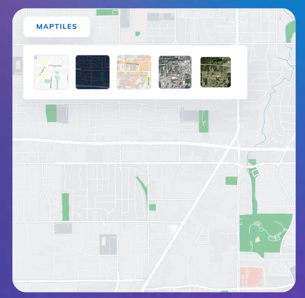
You can create engaging branded experiences by refining maps tailored to their specific needs and branding objectives with Maptiles API. With the ability to style maps based on various data properties such as points of interest (POI), traffic patterns, and geographical features, you can design base maps with different themes, ensuring seamless integration with their branding strategies.
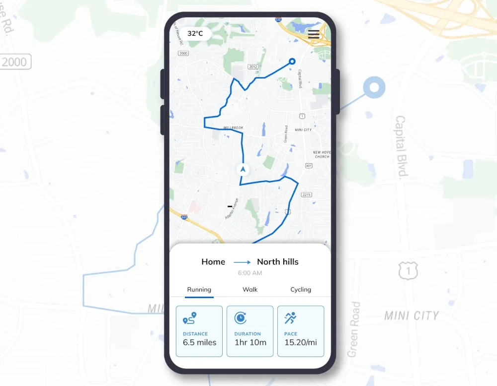
Additionally, NextBillion.ai enables the creation of dynamic and interactive map experiences, allowing for smooth navigation, zooming, and switching between map layers. These customizable maps can be seamlessly integrated into websites, apps, and business software, providing users with engaging and tailored navigation experiences.
By highlighting nearby points of interest, displaying weather visualizations, and tracking orders, businesses can drive user engagement and satisfaction. Moreover, NextBillion.ai optimizes map load times by displaying static maps as lightweight images, improving overall performance and driving user engagement.
The platform also offers mobile-optimized maps designed to deliver a seamless navigation experience on mobile devices, ensuring consistency and usability across different platforms.
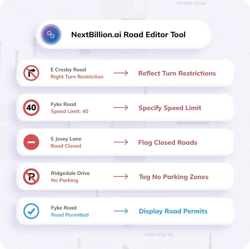
Additionally, NextBillion.ai’s Road Editor Tool (RRT) allows users to set up various restrictions, enhancing maps with detailed restrictions such as turn restrictions, speed limits, and road closures.
Feature 2: Custom Feature Development
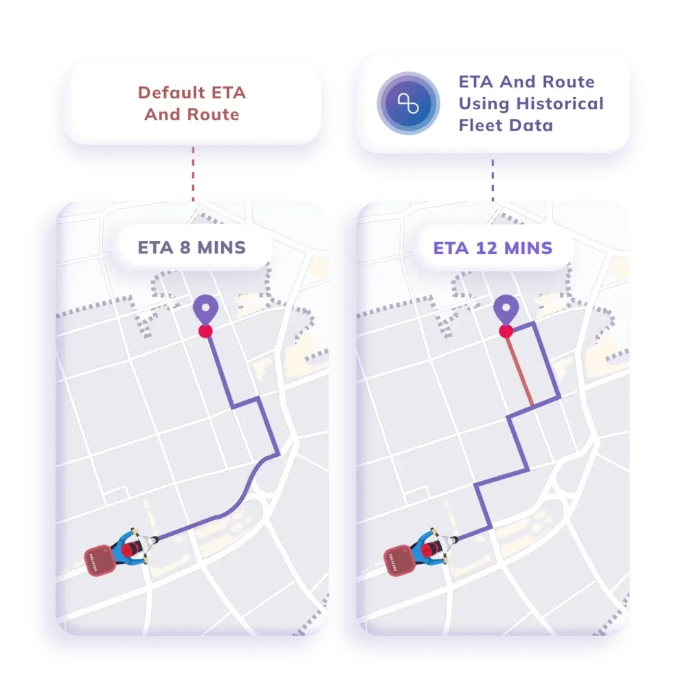
NextBillion.ai offers enterprise-grade customizations, enabling businesses to leverage their data effectively with AI-powered APIs. By utilizing historical data from drivers and vehicles, you can get more accurate ETAs and routes optimized to align with real-world driver behavior. This level of customization enhances operational efficiency and ensures optimal resource allocation.
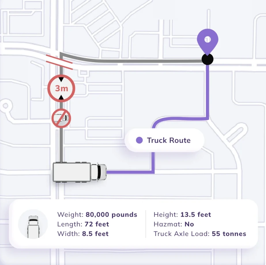
Feature 3: Truck Specific Routing Support
One of NextBillion.ai’s standout features is its ability to generate regulation-compliant routes tailored to truck dimensions such as width and height.
You can plan routes that adhere to safety regulations and avoid restricted areas, ensuring compliance and mitigating potential risks. Moreover, the platform facilitates multi-day Hours of Service (HOS) compliant routes, allowing for efficient planning and execution of long-haul trips.
You can select toll and toll-free alternative routes, optimize routes with over 50 constraints, and integrate existing telematics vendors seamlessly. NextBillion.ai also provides mileage and speed limit violation reports, enabling businesses to monitor and address compliance issues effectively.
NextBillion.ai Pricing
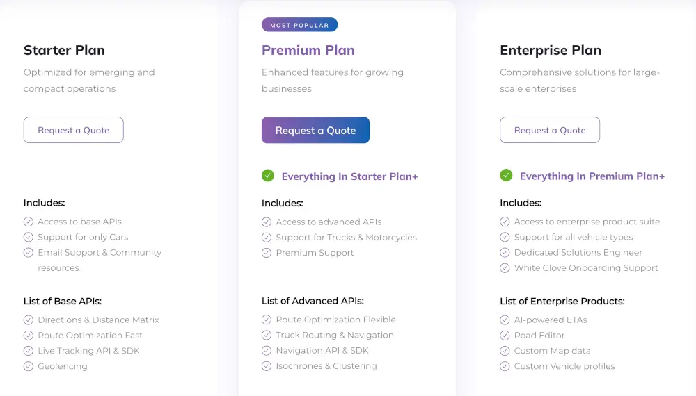
NextBillion.ai offers flexible pricing plans tailored to meet the diverse needs of businesses, whether you are an emerging startup or a large-scale enterprise.
1. Starter Plan: Optimized for emerging and compact operations, the Starter Plan provides access to essential base APIs tailored for early-stage businesses. This plan includes features such as Directions & Distance Matrix, Route Optimization Fast, Live Tracking API & SDK, and Geofencing.
While primarily designed for car-based operations, you can use email support and community resources for assistance.
2. Premium Plan: Ideal for growing businesses, the Premium Plan offers enhanced features to support scalability and expansion. In addition to everything included in the Starter Plan, users gain access to advanced APIs catering to a wider range of vehicle types, including trucks and motorcycles.
Premium Support is also provided to ensure seamless integration and ongoing assistance. Advanced APIs available under the Premium Plan include Route Optimization Flexible, Truck Routing & Navigation, Navigation API & SDK, and Isochrones & Clustering.
3. Enterprise Plan: For large-scale enterprises requiring comprehensive solutions, NextBillion.ai offers the Enterprise Plan. This plan encompasses everything included in the Premium Plan, with additional access to the enterprise product suite.
Support for all vehicle types is provided, along with dedicated Solutions Engineer assistance and White Glove Onboarding Support for a smooth transition. Enterprise-grade features such as AI-powered ETAs, Road Editor, Custom Map data, and Custom Vehicle profiles are available to meet the complex needs of large organizations.
With NextBillion.ai’s flexible pricing options, users can choose the plan that best aligns with their current requirements and future growth trajectory, ensuring they have access to the necessary tools and support to optimize their routing and mapping operations.
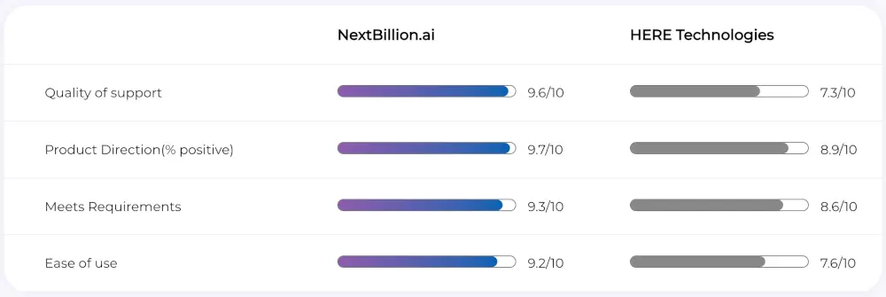
Comparison between Nextbillion.ai and HERE
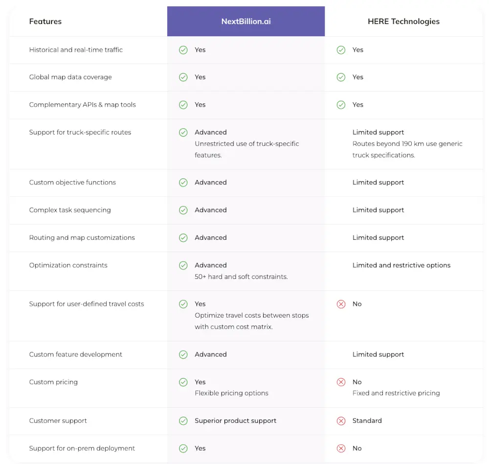
When comparing NextBillion.ai and HERE Technologies, both platforms offer essential features like historical and real-time traffic data, global map coverage, and complementary APIs.
However, NextBillion.ai stands out with its advanced support for truck-specific routes, providing unrestricted features crucial for precise trucking operations, unlike HERE Maps’ limited support.
NextBillion.ai excels in customization capabilities, allowing users to implement custom functions, task sequencing, and extensive map customizations, empowering tailored routing solutions effectively.
With over 50 optimization constraints and support for user-defined travel costs, NextBillion.ai offers unparalleled flexibility, a feature not present in HERE Maps by HERE Technologies.
NextBillion.ai Pros and Cons
✅NextBillion.ai offers advanced route optimization capabilities with support for over 50+ constraints
✅The flexible pricing model is beneficial for businesses to predict and cut down operational costs.
✅With advanced support and a flexible tech-stack, you can integrate the mapping functionality quickly.
❌NextBillion.ai is not suitable for individual users to perform day-to-day tasks.
❌The driving mode is limited to trucks and cars.
Google Maps is a widely-used mapping service renowned for its comprehensive maps, real-time traffic updates, street view imagery, and public transportation information. Users rely on its user-friendly interface and robust features for navigation and location-based services.
Who is it for?
Google Maps is perfect for individuals and businesses with no customization needs and small-scale operations. It is perfect for planning trip itineraries and small delivery business operations.
Google Maps Features
Google Maps provides highly accurate mapping data and extensive coverage, offering detailed maps of various regions worldwide. Users can access up-to-date information on roads, landmarks, and points of interest.
With an intuitive interface and easy-to-use features, Google Maps offers a seamless navigation experience for users across different devices and platforms.
Google Maps Pricing
Google Maps offers a freemium model, where basic usage is free for individuals and small businesses. However, businesses with heavy usage or specific needs may incur charges based on API usage, such as map loads, routes, and searches.
Google Maps Pros and Cons
✅Real-Time Traffic Updates: Google Maps offers real-time traffic information, helping users avoid congestion and plan efficient routes for their journeys.
✅Street View Imagery: Street View imagery allows users to explore locations virtually, providing a realistic view of streets, landmarks, and businesses.
✅Public Transportation Information: Google Maps integrates public transportation information, including schedules, routes, and transit options, making it easy for users to plan their journeys using buses, trains, and other modes of transportation.
❌Privacy Concerns: Google Maps collects a significant amount of user data, including location history and search queries, raising privacy concerns among some users.
❌Data Collection Practices: Google’s data collection practices, like tracking user location and behavior, have raised privacy and security concerns, prompting scrutiny from regulators and advocacy groups.
❌Limited Offline Functionality: While Google Maps offers offline maps for certain regions, its offline functionality is limited compared to some other mapping services, requiring users to have an internet connection for full functionality.
Waze offers a unique navigation experience centered around crowdsourced traffic updates and community-driven navigation assistance. While it may not offer as detailed map data or offline functionality as HERE Maps, Waze excels in providing real-time navigation assistance tailored to current road conditions and user input.
Who is it for?
Waze caters to individuals who prioritize real-time traffic updates and community-driven navigation assistance. It’s ideal for commuters, travelers, and anyone looking for efficient route planning and navigation assistance.
Waze Features
Waze distinguishes itself with its focus on crowdsourced traffic updates, road closures, and real-time incident reports. Key features include:
Social Interaction: Waze encourages social interaction among users by allowing them to share real-time traffic and road information, such as accidents, hazards, and police sightings. This collaborative approach enhances the accuracy and timeliness of traffic updates.
Route Optimization Based on User Input: Waze dynamically adjusts routes based on user input and real-time traffic data, offering optimized navigation tailored to current road conditions and user preferences.
Community-Driven Alerts: Users can receive alerts and notifications about road closures, accidents, police presence, and other incidents reported by the Waze community. This feature enables proactive navigation and helps users avoid potential delays or hazards.
Waze Pricing
Waze is available for free to all users, offering basic navigation and traffic updates. However, the app may display advertisements to support its free service. Additionally, Waze offers a Waze Carpool service for users interested in carpooling with others for their commute, with pricing based on distance and other factors.
Waze Pros and Cons
✅Crowdsourced Traffic Updates: Waze leverages crowdsourced data to provide real-time traffic updates and navigation assistance, ensuring users receive accurate and up-to-date information about road conditions.
✅Dynamic Route Optimization: Waze dynamically adjusts routes based on user input and real-time traffic data, offering optimized navigation that takes into account current road conditions and potential traffic congestion.
✅Community-Driven Alerts: Users benefit from community-driven alerts about road closures, accidents, and other incidents, enabling proactive navigation and avoiding potential delays or hazards.
❌Limited Map Data: Waze may not offer as detailed map data as some other navigation apps, potentially leading to inaccuracies or limitations in navigation assistance.
❌Offline Functionality: While Waze does offer limited offline functionality, such as basic map viewing and route planning, it may not provide the same level of offline functionality as other navigation apps like HERE Maps. Users may need an internet connection for full functionality and real-time updates.
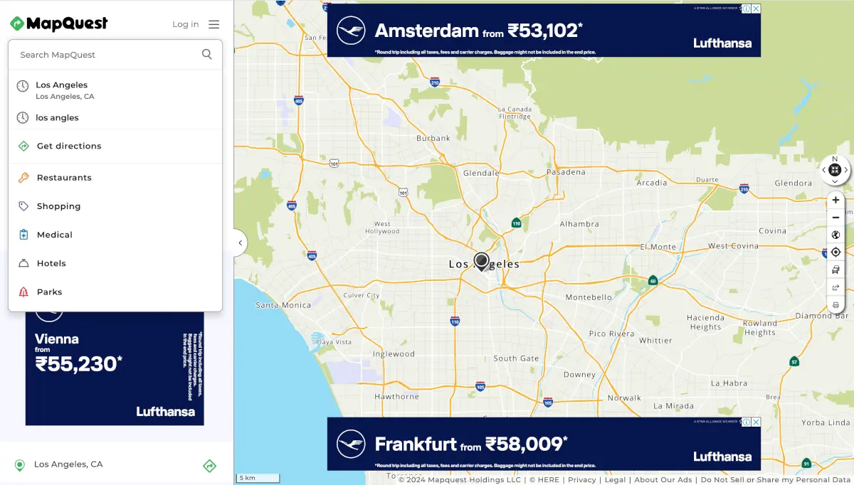
MapQuest offers a user-friendly mapping service with basic navigation and route planning features.
Who is it for?
MapQuest caters to individuals and businesses seeking a reliable mapping service for driving directions, local search, and route planning. It’s suitable for commuters, travelers, and anyone looking for easy-to-use navigation tools.
MapQuest Features
MapQuest offers a range of features to simplify navigation and route planning:
- Driving Directions: MapQuest provides detailed driving directions to help users navigate from one location to another efficiently.
- Local Search: Users can search for nearby businesses, restaurants, hotels, and other points of interest using MapQuest’s local search feature.
- Route Planning Tool: MapQuest’s route planning tool allows users to customize their routes, add multiple stops, and optimize their travel plans for efficiency.
- Customizable Maps: MapQuest allows users to customize their maps by adding annotations, markers, and notes, making it easier to personalize navigation experiences.
- Traffic Updates: MapQuest provides real-time traffic updates, allowing users to avoid congestion and plan their routes accordingly.
- Integration with Other Platforms: MapQuest integrates with other platforms and services, such as third-party apps and websites, to provide seamless navigation experiences across different platforms.
MapQuest Pricing
MapQuest is available for free to all users, offering basic navigation and route planning features. However, MapQuest also offers a MapQuest Pro subscription service for businesses and organizations with advanced mapping and routing needs. Pricing for MapQuest Pro varies depending on the specific features and usage requirements.
MapQuest Pros and Cons
✅ Easy-to-Use Navigation Tools: MapQuest offers intuitive navigation tools that are easy to use, making it simple for users to find driving directions and plan their routes.
✅ Local Search Integration: MapQuest integrates local search functionality, allowing users to find nearby businesses and points of interest with ease.
✅ Customizable Maps: MapQuest’s customizable maps feature allows users to personalize their navigation experiences by adding annotations, markers, and notes to their maps.
❌ Limited Mapping Data: MapQuest may not provide as detailed mapping data as some other mapping services, potentially leading to inaccuracies or limitations in navigation assistance.
❌ Lack of Advanced Features: MapQuest may not offer as many advanced features as some other mapping services like HERE Maps, limiting its functionality for users with specific mapping and routing needs.
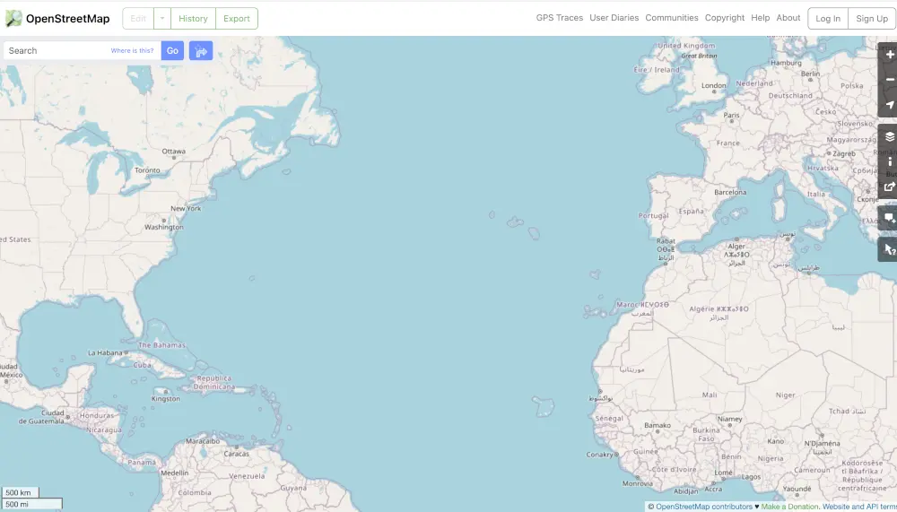
OpenStreet Map provides accessible mapping solution with its free and editable map data, global coverage, and community-driven updates. OpenStreet Map remains a reliable choice for users seeking customizable mapping solutions without financial barriers.
Who is it for?
OpenStreet Map caters to a wide range of users, including developers, businesses, and individuals seeking access to free and editable map data. It’s particularly useful for those looking for customizable mapping solutions for various applications, such as bike routing, heat maps, and mobile navigation apps.
OpenStreet Map Features
OpenStreet Map stands out for its crowd-sourced geographic data, providing users with reliable and up-to-date mapping information contributed by volunteers worldwide. Key features include:
- Global Coverage: OpenStreet Map offers global coverage, providing detailed street map information in dozens of languages. Users can access map data for virtually any location worldwide.
- Community-Driven Updates: OpenStreet Map relies on community-driven updates, allowing users to contribute and edit map data collaboratively. This collaborative approach ensures that map data remains accurate and up-to-date, reflecting changes and developments in real-time.
- Free and Editable Map Data: All features of OpenStreet Map are free to use, with no need for an API key. Users can access and edit map data freely, allowing for customization and adaptation to specific needs and requirements.
OpenStreet Map Pricing
OpenStreet Map is entirely free to use, with no costs associated with accessing its features or using its map data.
OpenStreet Map Pros and Cons
✅ Free and Editable Map Data: OpenStreet Map offers free access to editable map data contributed by volunteers worldwide, making it one of the most reliable free mapping APIs available.
✅ Global Coverage: With detailed street map information available in dozens of languages, OpenStreet Map provides global coverage, making it suitable for diverse applications and use cases.
✅ Community-Driven Updates: OpenStreet Map relies on community-driven updates, ensuring that map data remains accurate and up-to-date through collaborative contributions and edits.
❌ Lack of Certain POI Types: OpenStreet Map’s database lacks certain points of interest (POI) types, such as hospitals and police stations, which are available on other free mapping services. This limitation may affect the completeness of map data for specific locations or applications.
❌ Limited Official Support: Compared to some other mapping services OpenStreet Map offer limited official support, potentially leading to challenges in troubleshooting or resolving issues for users.
Apple Maps offers a reliable mapping and navigation solution for users within the Apple ecosystem, with seamless integration with iOS devices and privacy-focused features.
Who is it for?
Apple Maps is primarily designed for users within the Apple ecosystem, including iOS, macOS, and watchOS users. It caters to individuals who prefer seamless integration with Apple devices and seek reliable navigation and mapping solutions.
Apple Maps Features
Apple Maps offers a range of features designed to provide comprehensive mapping and navigation experiences:
- Turn-by-Turn Navigation: Apple Maps provides turn-by-turn navigation, guiding users with spoken directions and real-time traffic updates to reach their destinations efficiently.
- Public Transit Directions: You can access public transit directions, including bus and train routes, schedules, and estimated arrival times, making it easier to navigate urban areas using public transportation.
- 3D Flyover Views: Apple Maps offers 3D flyover views of select areas, allowing users to explore cities and landmarks in immersive detail.
Apple Maps Pricing
Apple Maps is free to use for all Apple device users, including iPhone, iPad, Mac, and Apple Watch users. There are no additional costs associated with accessing its features or using its navigation and mapping services.
Apple Maps Pros and Cons
✅ Seamless Integration with iOS Devices: Apple Maps seamlessly integrates with iOS devices, providing a native mapping solution for iPhone, iPad, and Apple Watch users.
✅ Privacy-Focused Features: Apple Maps prioritizes user privacy by anonymizing location data and minimizing data collection, ensuring that user information remains secure and confidential.
✅ Hourly Traffic Data Updates: Apple Maps includes hourly traffic data updates, allowing users to stay informed about current traffic conditions and plan their routes accordingly.
❌ Limited Customization Options: The free version of Apple Maps does not support custom map styles or points of interest (POIs), limiting users’ ability to personalize their mapping experiences.
❌ Occasional Inaccuracies: While Apple Maps strives to provide accurate mapping data, users may encounter occasional inaccuracies or errors compared to more established mapping services
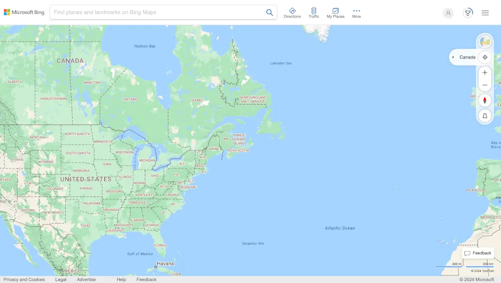
Bing Maps offers a range of mapping services with detailed aerial imagery, route planning capabilities, and customizable map styles.
Who is it for?
Bing Maps caters to developers, businesses, and individuals seeking mapping services with detailed aerial imagery and precise street-level detail. It’s particularly suitable for applications requiring route optimization, real estate sites, and location-based services.
Bing Maps Features
Bing Maps offers a range of features designed to meet various mapping and navigation needs:
- Detailed Aerial Imagery: Bing Maps provides detailed aerial imagery with precise street-level detail, allowing users to explore locations with high-resolution imagery.
- Street Maps: Users can access street maps for navigation and route planning, featuring detailed road networks, landmarks, and points of interest.
- Route Planning: Bing Maps offers route planning capabilities, allowing users to calculate optimal routes for driving, walking, and public transit.
- Customizable Map Styles: Users can customize map styles to suit their preferences and branding, including options for colors, labels, and symbols.
- Offline Mapping Support: Bing Maps supports offline mapping, allowing users to download maps for offline use and access them without an internet connection.
Bing Maps Pricing
Bing Maps offers a free API with hosting, geocoding, and route optimization services included. However, you need an API key to access these features, and the free version only supports basic functionality. Pricing for premium features and additional usage may vary depending on usage requirements.
Bing Maps Pros and Cons
✅ Free Hosting, Geocoding, and Route Optimization: Bing Maps offers free hosting, geocoding, and route optimization services, making it an affordable option for developers and businesses.
✅ Detailed Aerial Imagery: Bing Maps provides detailed aerial imagery with precise street-level detail, offering valuable insights for applications requiring visual context.
✅ Customizable Map Styles: Users can customize map styles to match their branding and preferences, ensuring a consistent and personalized mapping experience.
❌ Limited Free Features: The free version of Bing Maps only supports basic features, and users may need to upgrade to access premium functionality or additional usage limits.
❌ Coverage and Data Limitations: Bing Maps may not offer as extensive coverage or detailed data as some other mapping services like HERE Maps, potentially limiting its suitability for certain applications or regions.