


Route Optimization API
Optimize routing, task allocation and dispatch
Distance Matrix API
Calculate accurate ETAs, distances and directions
Directions API
Compute routes between two locations
Navigation API & SDK
Turn by Turn Instructions for Drivers & Technicians
Route Optimization Software
Plan optimized routes with 50+ Constraints
Product Demos
See NextBillion.ai APIs & SDKs In action
AI Route Optimization
Learns from Your Fleet’s Past Performance
Platform Overview
Learn about how Nextbillion.ai's platform is designed
Road Editor App
Private Routing Preferences For Custom Routing
On-Premise Deployments
Take Full Control of Your Maps and Routing
About Us
Our story, vision
and mission
Contact Us
Reach out to us for any product- or media-related queries
Write to us at

Table of Contents
Route efficiency remains one of the biggest operational challenges in logistics because last-mile delivery can account for nearly 53% of total shipping costs. As delivery networks expand across warehouses, drivers, and thousands of destinations, calculating routes individually becomes both inefficient and expensive. This is where Distance Matrix APIs become essential. By processing large-scale travel relationships simultaneously, they help logistics systems improve ETA accuracy, optimize fleet operations, reduce transportation costs, and enable smarter routing decisions at scale.
Read this blog to learn about Distance Matrix APIs, how they work, their benefits, applications, and logistics trends in 2026:
Distance Matrix APIs are used to estimate journey distance, estimated travel time, and route intelligence between various origins and destinations in a single request within logistics platforms. They do not compute routes one at a time but instead produce large-scale travel matrices that enhance fleet optimization, ETA accuracy, route planning, and the cost-effectiveness of logistics operations. These APIs:
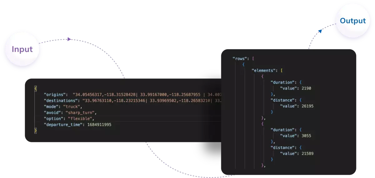
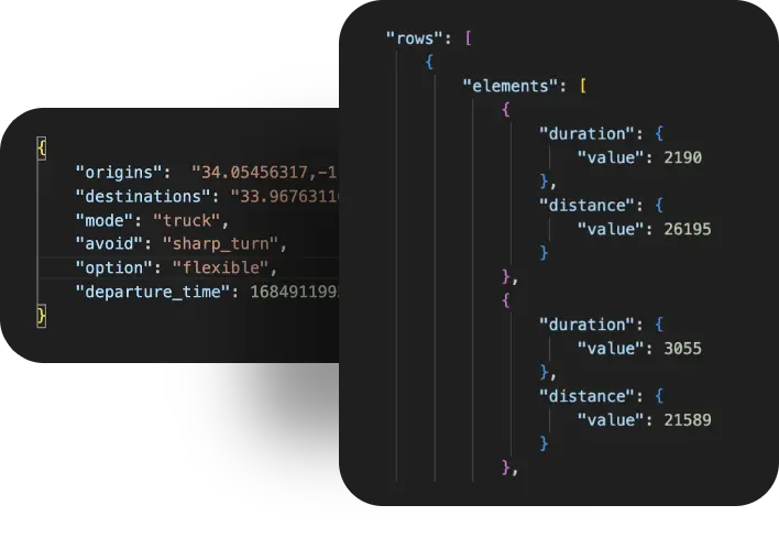
A Distance Matrix API is a routing and spatial computing service that computes distance, estimated travel time, and route intelligence between two or more origin and destination pairs in a single request. The API can efficiently compute thousands of route combinations instead of calculating individual point-to-point routes by constructing an N×M matrix format, where each row corresponds to an origin and each column corresponds to a destination.
Modern Distance Matrix APIs combine graph-based routing algorithms, geospatial indexing, road network data, live traffic intelligence, historical mobility patterns, and predictive ETA models to generate highly accurate travel estimates. These APIs serve as a data layer in logistics systems to support route optimization engines, fleet dispatch systems, warehouse allocation models, last-mile delivery planning, and operational cost prediction.
Consider a logistics company operating from one warehouse and delivering orders to multiple customer locations.
Origin: Point A → Warehouse Hub
Destinations:
Point B → Customer Location 1
Point C → Customer Location 2
Point D → Customer Location 3
Point E → Customer Location 4
Instead of calculating routes individually:
A Distance Matrix API processes all combinations simultaneously and returns a travel matrix:
From | To | Distance | Travel Time |
Point A | Point B | 8 km | 15 mins |
Point A | Point C | 14 km | 22 mins |
Point A | Point D | 11 km | 18 mins |
Point A | Point E | 20 km | 35 mins |
The logistics platform can now apply optimization logic:
For example, when Point D and B are geographically near and have less combined travel time, the system can optimize the route as:
Point A → Point D → Point B → Point C → Point E
rather than using the original sequence of order. This saves time on traveling, enhances the density of delivery and minimizes the operational cost of the whole fleet.
The following are the most apparent benefits of the Distance Matrix API for Logistics that support organizations to enhance travel-time estimation, improve fleet management, reduce delivery costs, and expand route intelligence across large transportation networks:
Distance Matrix APIs are highly beneficial in planning routes within logistics systems that manage multi-stop deliveries across extensive geographic coverage. The API does not compute travel routes on a case-by-case basis but instead computes hundreds or thousands of origin-destination pairs simultaneously and provides structured travel intelligence. This matrix data is used by route optimization engines to determine the most efficient delivery path.
It is also used to minimize route overlap, reduce empty travel segments, and maximize delivery density per trip. For logistics companies involved in courier services, retail distribution, or last-mile delivery services, this reduces travel inefficiencies and enables fleets to complete more deliveries within the same operational window.
Static route estimates often fail because travel conditions continuously change throughout the day. Distance Matrix APIs combine live traffic conditions, road congestion, historical mobility patterns, route restrictions, and real-time transportation data to calculate dynamic ETAs. These APIs are increasingly used by modern logistics platforms alongside predictive analytics systems to continuously update delivery estimates during transit.
Precise ETA forecasting improves customer communication, reduces failed delivery attempts, and decreases customer support requests. It also assists operations teams in handling delivery commitments more efficiently.
Fuel costs are among the biggest operational expenses across logistics environments, particularly for large fleet operators. Distance Matrix APIs assist route intelligence systems in providing travel-efficient paths based on time, congestion, and road conditions instead of relying only on the shortest physical distance.
Shorter distance routes may not necessarily be less expensive if they contain road bottlenecks or slow-moving traffic sections. Minimizing idle time, avoiding congestion-prone routes and unnecessary vehicle movement, and streamlining route structures can help organizations reduce fuel consumption and improve overall fleet productivity.
Assigning drivers solely based on geographic proximity can be highly inefficient because even nearby vehicles may encounter traffic congestion, route restrictions, or delays. Distance Matrix APIs enable dispatch systems to analyze actual travel time between available drivers and delivery locations. Fleet management systems can compare multiple drivers simultaneously and determine which resource can reach the destination most efficiently.
This improves dispatch accuracy, increases delivery speed, reduces driver idle time, supports optimal workload balancing, and allows logistics systems to maximize the utilization of available fleet resources.
Modern logistics organizations increasingly operate through distributed warehouse structures located across multiple cities and regions. Distance Matrix APIs help determine which warehouse can fulfill an order with the shortest estimated delivery time and lowest operational cost.
Instead of selecting fulfillment centers solely based on inventory availability or geographic distance, logistics systems can consider traffic conditions, travel time, transportation costs, and route efficiency. This supports better inventory movement decisions, next-day and same-day delivery models, reduced shipping costs, and improved supply chain responsiveness across large operational networks.
Distance Matrix APIs are based on a stacked computational process that converts raw location inputs to actionable travel intelligence. The API does not compute routes one by one but computes many combinations of origins and destinations at once. It produces a structured matrix with information on travel distance, estimated time, traffic conditions, and routing. This architecture enables logistics systems to make thousands of calculations related to deliveries effectively and operate large fleets.
The initial step is to find the origin points that indicate the origin of travel requests. Examples of origins in logistics settings would be warehouses, regional fulfillment centers, fleet hubs, dark stores, pickup stations, or active vehicles on the road sending live GPS positions.
For example:
Warehouse, Chicago = Point A
Point X = Distribution Center, Dallas
Point Y = Fleet Hub, Atlanta
These locations can be continuously fed by large logistics systems by:
Prior to travel computation, systems check inputs of location and transform them into standardized coordinate formats. Bad coordinates or wrong addresses may have a great impact on the accuracy of routing.
For example:
Warehouse Chicago:
Latitude: 41.8781
Longitude: -87.6298
Warehouse Dallas:
Latitude: 32.7767
Longitude: -96.7970
This is the normalization phase that makes sure that there is uniform processing among routing systems.
The second step is to collect destination points whereby transportation requests should be fulfilled. Destinations can be addresses of customers, retail outlets, delivery areas, service centers, or pickup locations.
Example:
Point B = Customer, Houston
Point C = Customer, Austin
Point D → Customer, San Antonio
Point E → Customer, Fort Worth
The majority of logistics platforms initially take the destination information in the form of textual addresses and not coordinates.
Example:
2450 West Loop South, Houston, Texas.
The addresses cannot be processed by the routing systems. Thus, geocoding services transform the addresses into latitude and longitude.
Example:
Houston customer:
Latitude: 29.7604
Longitude: -95.3698
This conversion generates machine-readable geographic input to the route computation engines.
Traditional route systems execute one route request at a time:
Warehouse → Customer A
Warehouse → Customer B
Warehouse → Customer C
This method is inefficient at a large scale.
The Distance Matrix APIs, on the other hand, automatically generate combinations.
For Point A:
For Point X:
For Point Y:
In the event that a logistics network has:
50 warehouses
500 destinations
The API can handle: 50 × 500 = 25,000 route relationships within one matrix operation.
This architecture drastically decreases the number of computations of routes and enhances the efficiency of the computation.
After the creation of matrix relationships, the routing engine starts to make travel intelligence calculations. The APIs of Modern Distance Matrix do not just consider physical distance. They combine:
Graph representations of transportation networks are an internal representation of most modern systems:
Intersections → Nodes
Road segments → Edges
The routing algorithms are used to analyze these relationships in the graph in order to come up with feasible routes.
For example:
Straight-line geographic distance:
Point A → Point B = 12 miles
Actual road route:
Point A → Point B = 19 miles
Travel duration:
32 minutes
Traffic delay:
7 minutes
This difference is important since real cars move through roads, crossings, and traffic networks instead of direct geographic routes.
Once the routing computations are finished, the API provides a structured response in the form of a matrix, which has travel intelligence.
Example:
From | To | Distance | Travel Time | Traffic Delay | Toll Cost |
Point A | Point B | 19 miles | 32 mins | 7 mins | $3 |
Point A | Point C | 27 miles | 39 mins | 5 mins | $4 |
Point A | Point D | 43 miles | 57 mins | 11 mins | $6 |
The new APIs might also be returned:
The result is a travel intelligence layer as opposed to plain mapping data.
The last step utilizes business logic and optimization principles on the outputs of matrices.
Assume that the API is:
Point A → Point B = 32 mins
Point X → Point B = 18 mins
Point Y → Point B = 24 mins
The system uses Point X since the actual travel time is minimal as opposed to the geographically closest warehouse.
The outputs of matrices can also be used by logistics systems to:
The final optimization layer transforms raw travel computations into high-scale operational choices that can power contemporary logistics ecosystems.
The following are five specific applications of Distance Matrix APIs to logistics platforms to enhance the efficiency of operations and the routing scale of large-scale operations:
Here are the key future trends in distance intelligence for 2026:
Traditional travel estimation models primarily respond to existing traffic conditions. The future of distance intelligence is shifting toward AI-based predictive ETA engines that can process historical mobility patterns, weather conditions, seasonal trends, road incidents, driver behavior, and real-time traffic signals.
These systems do not simply report current travel conditions but also anticipate how traffic is likely to change during a journey. Machine learning models are increasingly being adopted across logistics platforms to generate more precise arrival windows, reduce delivery delays, and improve route reliability at scale.
Distance intelligence is slowly moving away from centralized cloud computing toward edge computing systems. Vehicles, IoT sensors, and delivery devices in large logistics environments are adopting routing information processing closer to the data source rather than relying solely on distant servers.
Edge-enabled route systems minimize latency, enable faster travel calculations, and support route modifications in near real time. This is particularly significant in high-volume delivery networks where even minor processing delays can affect fleet efficiency.
One of the significant innovations in travel intelligence systems is the use of digital twins. A logistics digital twin is a virtual simulation of physical transportation networks, warehouses, vehicles, traffic flows, and delivery routes. Before actual deployment, distance intelligence systems can simulate thousands of routing scenarios.
In virtual environments, organizations can experiment with congestion events, weather disruptions, changes in warehouse demand, and fleet allocation strategies to identify operational bottlenecks before they impact actual deliveries.
The emergence of same-hour and ultra-fast commerce models is creating a need to have hyperlocal travel intelligence systems. The classical route computations that are used in long-distance movement are not applicable in very dense urban settings, where a slight alteration in route can cause a great deal of variation in delivery times.
The future distance intelligence systems are becoming more and more aware of micro-location, local traffic trends, lane-level route navigation, and neighborhood movement patterns to enhance delivery accuracy in small geographic areas.
Connected mobility infrastructure is likely to become more and more important in future transportation ecosystems, with Vehicle-to-Everything (V2X) communication technologies. Cars, traffic, road networks, and transport platforms can constantly communicate with each other in terms of operational information.
Distance intelligence systems coupled with V2X environments can dynamically modify predictions of travel in response to updates in traffic signals, road conditions, construction alerts, and networks of transportation. This enables routing systems to be more dynamic and aware of the context as opposed to using only fixed road information.
With the increasing complexity of logistics and the calculation of routes in the thousands of different travel combinations, more and more businesses are in need of mapping and routing solutions designed with large volumes of transportation intelligence and enterprise logistics workloads.
At NextBillion.ai, we focus on solving routing and mapping challenges for businesses operating at scale. When an organization handles thousands of deliveries, fleet movements and route calculations at a time, traditional mapping systems tend to fail. Our platform is intended to serve the logistics providers, transportation networks, and enterprise mobility systems that demand high-volume route calculation and travel intelligence in complicated operational settings.

We offer Distance Matrix APIs that can efficiently handle large sets of origins and destinations and use real-life transportation factors like traffic congestion, road closures, vehicle limitations, and route biases. We use our routing infrastructure to enable businesses to create more precise ETAs, better fleet allocation decisions, and better route planning in multi-stop delivery networks. This facilitates the capacity of logistics systems to go beyond just distance calculations and make decisions based on viable travel intelligence.
Our APIs can be used in logistics platforms, transportation management systems, dispatch applications, and tailored mobility solutions. We advocate scalable infrastructure needs where organizations require an identical routing performance over extensive geographic networks. Using mapping intelligence and configurable routing logic, we enable businesses to create transportation systems that enhance operational efficiency, lower delivery costs, and enable growth in an ever-more-complicated logistics environment.
Distance Matrix APIs are no longer just route calculation tools but have become essential logistics infrastructure for modern transportation systems. They enable organizations to optimize fleet performance and reduce operational costs by integrating travel intelligence, real-time traffic awareness, ETA prediction, and large-scale route computation. As logistics networks continue to expand in 2026, Distance Matrix APIs will increasingly support smarter routing decisions, efficient last-mile operations, and scalable delivery ecosystems.
Ready to scale logistics intelligence? Explore how NextBillion.ai can help optimize routing, ETAs, and large-scale transportation operations. Connect with us to know more.
Distance Matrix API computes the distance between multiple origin and destination points in a single request to compute routing, estimated travel time and fleet optimization.
It assists logistics platforms in route optimization, assigning nearby drivers, eliminating unnecessary travel, and enhancing delivery sequencing to facilitate quicker operations.
Yes. Modern Distance Matrix APIs apply real-time traffic conditions, past mobility data, and road intelligence to give dynamic travel estimates.
Distance Matrix APIs are commonly used in logistics, food delivery, ride-sharing, courier, e-commerce, transportation, and fleet management platforms.
They compute thousands of combinations of origin-destination at once, assisting organizations to enhance ETAs, decrease operational expenses, and efficiently scale routing operations.
Bhavisha Bhatia is a Computer Science graduate with a passion for writing technical blogs that make complex technical concepts engaging and easy to understand. She is intrigued by the technological developments shaping the course of the world and the beautiful nature around us.

