Table of Contents
NextBillion.ai is designed for businesses and industries that need advanced, customizable mapping solutions, particularly in areas like logistics, transportation, and delivery. It offers superior route optimization, data integration, and flexibility. Its customization options make it suitable for handling complex, industry-specific challenges.
NextBillion.ai stands out for its unique and vast features in comparison to MapQuest. Nextbillion.ai offers best features with respect to the following categories:
1. Customization and Flexibility
NextBillion.ai provides a wide range of customization choices and is intended for businesses with particular requirements. You can personalize geospatial data to particular use cases, optimize routes for certain business objectives, generate custom map layers, and many more.
The NextBillion.ai Platform enables accurate and optimal solutions for a variety of industries, including logistics, delivery, ride-hailing, and more. The platform supports custom routing and map data. Overall, Nextbillion.ai provides industry-specific solutions.
2. Route Optimization
NextBillion.ai is particularly good at optimizing routes for complex logistics and transportation systems. It can handle multi-stop routes, time windows, vehicle capacity constraints, and more, making it ideal for businesses with complex routing needs.
Based on current traffic, weather, and other dynamic variables, the platform allows for real-time route alterations.
3.Data and Mapping Accuracy
You can integrate custom datasets, such as private road networks or proprietary geospatial data, into NextBillion.ai’s platform. This allows for highly accurate and context-specific maps.
NextBillion.ai supports dynamic updates and custom map data, ensuring that the maps reflect the most current and relevant information for specific use cases.
4. API and Developer Support
NextBillion.ai offers a robust set of APIs for routing, geocoding, map visualization, and more. These APIs are designed to support complex, large-scale applications, particularly in enterprise environments.
The NextBillion.ai platform provides strong developer support, with a focus on enterprise solutions, including dedicated customer support and customization services.
✅ User-Friendly Interface: NextBillion.ai is known for its intuitive interface, making it simpler for developers to integrate and make use of its services. This high ranking indicates that you can easily explore and use the platform in your applications.
✅ Customization Options: The platform’s strong customization features enables you to adapt location-based services, routing, and mapping to meet particular requirements. This flexibility is especially helpful for companies with special needs.
✅ Rich Feature Set: NextBillion.ai offers a comprehensive range of features, including map rendering, geocoding, and advanced routing options. The feature set is sufficiently strong to accommodate a wide range of use cases, from straightforward route optimization to intricate map integration.
✅ Specialized Routing: The platform is excellent at offering geographic data management and custom vehicle routing, two features that are useful for logistics and transportation companies.
✅ Advanced Algorithms: NextBillion.ai uses advanced algorithms for route optimization, which can help in reducing travel time and costs, particularly in complex situations involving several waypoints or specific vehicle types.
✅ Customizability: For users in need of specialized solutions, the option to modify routes according to different parameters (such as vehicle type and traffic circumstances) offers a great deal of value.
❌ Depending on the user’s location, NextBillion.ai may not offer much coverage or less optimized data in certain regions compared to more established global providers. This could affect the accuracy and quality of maps and routing in less populated or developing areas.
❌ Although the platform offers a good range of features, it may lack some advanced or niche functionalities that are available in more developed platforms. For example, specific industry-focused solutions might not be as developed.
Custom Pricing: NextBillion.ai typically offers custom pricing plans based on the specific needs and scale of the business. While this can be cost-effective for large enterprises, it may be less accessible for smaller projects or businesses with limited budgets.
NextBillion.ai pricing is designed to align with the value you get. You can choose from three product bundles depending on your use cases and three pricing units – per-order, per-asset or per-API call depending on your business model. The per unit price is calculated based on your monthly usage volume and average order value (per unit cost goes lower as volumes increase and average order value decreases). A free trial of Nextbillion.ai is also available.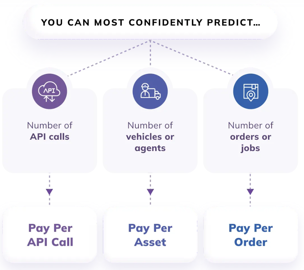
NextBillion.ai offers flexible pricing plans tailored to businesses’ diverse needs. Whether a company is an emerging startup or a large-scale enterprise, there’s a plan designed to optimize delivery operations efficiently.
Google Maps is a comprehensive, feature-rich platform that excels in almost every aspect of mapping and navigation, making it suitable for a wide range of use cases, from everyday use to complex business applications. It offers advanced features, extensive global coverage, and a robust set of APIs for developers, but can be more costly and complex to implement.
Here are some of Google Maps’ features:
1. Mapping and Navigation
In this category, Google Maps offers a wide range of detailed maps covering almost every country, complete with streets, landmarks, and sites of interest (POIs). It provides accurate turn-by-turn navigation in real-time for bicycling, walking, driving, and public transportation. In addition, it offers turn notifications and lane guidance. With Street View, which provides 360-degree panoramic views of streets and landmarks in numerous areas worldwide, you may visually explore new places.
2. Traffic and Real-Time Information
When it comes to providing real-time traffic information, such as updates on events, road closures, and congestion, Google Maps is an excellent resource. Numerous sources, including user feedback and past traffic patterns, are used to collect this data. Google Maps helps you in avoiding traffic congestion and delays by constantly adjusting routes based on current conditions. In many cities across the world, it offers real-time timetables, delays, and route options for public transit systems.
3. Search and Points of Interest (POIs)
A regularly updated database of places of interest, including eateries, shops, landmarks, and more, may be found on Google Maps. It provides thorough details, user opinions, images, and business hours. Google Maps’ search feature is incredibly precise and context-aware; it frequently infers your purpose and provides pertinent recommendations. Based on your location and choices, you may find local activities, restaurants, and attractions with Google Maps’ “Explore” feature.
✅ Intuitive Interface: Despite the lower score, Google Maps is generally recognized for its easy-to-use interface, making it accessible to a wide range of users. The platform’s design allows you to quickly search for locations, get directions, and explore maps with minimal effort.
✅ Integrated Ecosystem: Google Maps seamlessly integrates with other Google services like Google Search and Google Assistant, enhancing the utility of location services. This integration allows for a more cohesive user experience across devices and applications.
✅ Turn-by-Turn Navigation: The platform offers detailed, voice-guided navigation, which is easy to follow and reliable. This feature is especially beneficial for drivers and pedestrians alike, providing clear directions with real-time adjustments.
❌ Inconsistent Map Updates: Despite Google’s efforts to keep maps current, users still encounter mapping issues, such as incorrect road layouts or missing routes, particularly in less developed or rural areas. These inconsistencies can lead to navigation errors or confusion.
❌ Interference with GPS Signals: Geolocation inaccuracies can also arise due to signal interference from surrounding structures or poor satellite visibility, leading to frustrating experiences, especially in critical situations like ridesharing or delivery services.
❌ Delayed Updates in Some Regions: Users may encounter outdated information, such as businesses that have closed, roads that have changed, or new developments not yet reflected on the map. This is particularly problematic in rapidly changing areas.
Google Maps is considered for its good navigation and mapping apps available, despite some areas for improvement.
In the following reviews, the customers are happy about how well the maps can be customised and its comprehensive features.
HERE WeGO is a robust mapping and navigation platform recognized for its extensive global coverage, precise data, and offline functionality. Initially developed by Nokia and now operated by HERE Technologies, it serves both personal and business users.
Here are some of HERE WeGO features:
✅ Extensive Offline Capabilities: HERE WeGo allows users to download entire countries or regions for offline use, making it highly useful for travelers and those in areas with poor internet connectivity. Offline maps include full navigation features, which is a significant advantage over some competitors that limit functionality when offline.
✅ Detailed Points of Interest (POI): The app includes a comprehensive database of POIs, including businesses, attractions, and public transport options, which enhances its utility for both everyday use and travel.
✅ Intuitive Design: The app has a clean and user-friendly interface, making it easy to navigate and use. Features are clearly laid out, and the app’s design is visually appealing, which enhances the overall user experience.
❌ Outdated or Inaccurate POIs: Some users report encountering outdated or incorrect information for points of interest, such as closed businesses or incorrect locations. This can be frustrating when relying on the app for finding specific destinations.
❌ Limited User-Generated Content: Compared to competitors like Google Maps, HERE WeGo has less user-generated content, which can result in slower updates and fewer reviews or photos for POIs.
❌ Learning Curve for New Users: While the app is generally user-friendly, some users may find the initial setup and navigation through certain features less intuitive compared to more mainstream options. This can result in a steeper learning curve for those unfamiliar with the app.
Many users highlight the offline maps feature as one of HERE WeGo’s best aspects. Travellers, in particular, appreciate the ability to download entire countries or regions and use them without an internet connection. This is especially useful in areas with poor connectivity or for those wanting to save on data usage.

Roadtrippers is a popular trip-planning app designed specifically for road trips, offering unique features that cater to travellers looking to explore interesting stops along their journey.
Here are some of Roadtrippers’ features:
✅ Customized Itineraries: Roadtrippers allows users to create detailed and personalized trip itineraries, including multiple stops, attractions, and scenic routes. The app is particularly strong in helping you to discover off-the-beaten-path destinations, quirky attractions, and hidden gems that might not be highlighted on traditional map services.
✅ User Reviews and Ratings: You can access reviews, ratings, and photos for many POIs, which helps in making informed decisions about where to stop.
✅ Booking Integrations: Roadtrippers integrates with booking platforms for hotels, activities, and rental cars, allowing users to book accommodations and activities directly from the app. This adds convenience by centralizing the planning and booking process.
❌ Free Version Restrictions: The free version of Roadtrippers limits you to planning trips with only a few stops (up to 7). To plan more complex trips with additional stops, users need to upgrade to the premium version. This limitation can be frustrating for users who want to plan longer or more detailed road trips without paying for a subscription.
❌ Ads in Free Version: The free version also includes ads, which you may find intrusive and detractful from the overall experience.
❌ User-Generated Content: The app relies on user-generated content for many of its reviews and POI updates, which can result in inconsistencies or less frequent updates compared to apps with dedicated data teams.
A standout feature for many users is the app’s ability to help them discover unique and lesser-known attractions along their route. This aspect is particularly popular among those who enjoy exploring off-the-beaten-path locations.

Maps.Me is an excellent choice for those who need reliable offline maps with global coverage, particularly for those travelling to remote or less developed areas. The app’s free access, comprehensive offline features, and extensive POI database make it a strong tool for travellers.
Here are some of Maps’ features:
✅ Full Offline Functionality: Maps.Me’s primary strength lies in its ability to provide detailed maps and navigation entirely offline. You can download maps for entire countries or regions and access them without an internet connection, making it ideal for travellers in areas with limited connectivity.
✅ Small File Size: Compared to other mapping apps, Maps.Me has a relatively small file size, which means it uses less storage space on your device. This efficiency is particularly beneficial when downloading multiple maps for offline use.
✅ Bookmarks and Favourites: You can save favourite locations and create custom bookmarks for easy access later, even when offline.
❌ Inconsistent Map Quality: Since Maps.Me relies on OpenStreetMap data, the quality and accuracy of the maps can vary depending on the region. Some areas may have incomplete or outdated information, especially in less populated or less frequently updated regions.
❌ No Live Public Transit Information: While the app provides walking and biking directions, it lacks real-time public transit information, making it less useful for users relying on buses, trains, or subways.
❌ Occasional Routing Errors: Some users report issues with routing, such as being directed down incorrect or non-existent roads, especially in remote areas or places where the map data is less reliable.
Many users praise Maps.Me for its robust offline capabilities. Travellers appreciate being able to download maps for entire countries or regions and access them without needing an internet connection. This feature is particularly valuable in areas with poor or no connectivity.

Waze stands out for its highly interactive approach, making it an essential tool for users seeking real-time, crowd-sourced traffic data, and efficient navigation.
Here are some of Waze’s features:
✅ Community Reporting: The app relies on its user community to report traffic conditions, road hazards, and speed traps, which enhances the accuracy and timeliness of the information.
✅ Adaptive Routes: Waze continuously adjusts routes based on current traffic conditions. If there’s a sudden traffic jam or road closure, the app will quickly reroute users to minimize delays.
✅ No Subscription Fees: Waze is free to download and use, with no subscription fees or premium versions required. It’s a cost-effective solution for users who need reliable navigation.
❌ High Data Consumption: Waze requires a constant internet connection to provide real-time updates and navigation. This can lead to high data usage, which may be a concern for users with limited data plans.
❌ Occasional Errors: Users may encounter occasional routing errors or outdated map information, particularly in less frequented areas.
❌ Focused on Driving: Waze is primarily designed for drivers and may not be as useful for users relying on public transit, biking, or walking. The app lacks features for these modes of transportation.
Many users praise Waze for its ability to provide accurate and up-to-date traffic information. The real-time updates on traffic jams, road closures, and accidents help users avoid delays and find faster routes.
OpenStreetMap is a highly flexible and community-driven mapping platform, making it valuable for specialized mapping needs, open-source projects, and offline navigation. It is widely used across industries and continues to grow through global volunteer efforts.
Here are some of OpenStreetMap’s features:
✅ Open License: The data is available under the Open Database License (ODbL), which allows you to freely use, modify, and distribute the data as long as they attribute OSM and share derivative works under the same license.
✅ Extensive Mapping: OSM offers mapping coverage for virtually every part of the world, including remote and less-developed areas that may not be well-represented in commercial mapping services.
✅ Collaborative Editing: The maps are continuously updated by a global community of volunteers. This collaborative approach ensures that the data is current and reflects local knowledge. You can contribute their local knowledge by editing and adding information, improving the accuracy and detail of the maps.
❌ Inconsistent Updates: While OSM is continuously updated, the frequency of updates can be inconsistent. Some areas may not have recent data or may lack certain details.
❌ Complexity: For new users or developers, working with OSM data can be complex. Understanding how to effectively use and manipulate the data may require a learning curve.
❌ Rendering Performance: For applications using OSM data, rendering large datasets or detailed maps can sometimes lead to performance issues, particularly if not optimized effectively.
The active and passionate community of contributors is often praised for continuously improving and updating the maps. The community-driven approach is seen as a strength that keeps the data relevant and current.

Circuit is an efficient and easy-to-use platform for optimizing multi-stop routes, particularly for delivery drivers and businesses. Its focus on route efficiency and delivery management tools makes it highly valuable for saving time and resources in logistics and service industries.
✅ Improved Efficiency: Circuit optimizes routes to minimize travel time and fuel costs, helping businesses improve overall efficiency.
✅Multiple Stops: It handles complex routes with multiple stops, making it suitable for delivery and service operations.
✅ Dynamic Routing: The app can dynamically adjust routes based on real-time conditions and new information, helping to account for changes in traffic or last-minute additions to the schedule.
✅ Fuel and Time Savings: By optimizing routes, Circuit helps you to reduce fuel consumption and travel time, leading to potential cost savings for businesses and individuals.
❌ Connectivity Issues: Circuit requires a stable internet connection to provide real-time updates and route optimization, which could be problematic in areas with poor connectivity.
❌ Initial Setup: Some users may experience a learning curve during the initial setup and configuration of the tool.
❌ Coverage: While Circuit is effective in many regions, its functionality and data accuracy may vary depending on geographic location.