


Table of Contents
Calculating accurate travel times and distances between multiple locations has long been a challenge for planners, dispatchers, and analysts across industries. Doing this manually—or even semi-manually with spreadsheets and basic mapping tools—can be time-consuming, error-prone, and practically impossible at scale.
The Distance Matrix Calculator: a lightweight, no-code web tool designed to convert a CSV of origin and destination coordinates into a fully-formed travel time and distance matrix. Built on top of the powerful NextBillion.ai Distance Matrix API, this tool delivers high-accuracy, real-world travel times and distances with support for various travel modes, traffic profiles, and advanced routing logic.
Whether you’re a logistics manager planning delivery routes, a GIS analyst building OD models, or an operations lead optimizing crew dispatch, the Distance Matrix Calculator is built to simplify your workflow, save time, and boost decision-making precision.
What Is a Distance Matrix?
A distance matrix is a table that shows the distance and/or travel time between sets of origin and destination points. Each row in the matrix represents an origin, and each column represents a destination. The cell values indicate the distance (in km or miles) or travel time (in minutes) between that origin-destination pair.
For example:
| Dest A | Dest B | Dest C | |
| Orig 1 | 5.2 km | 12.3 km | 7.8 km |
| Orig 2 | 6.1 km | 11.0 km | 8.6 km |
| Orig 3 | 3.3 km | 9.5 km | 5.1 km |
Distance matrices are foundational in:
- Logistics and delivery network optimization
- Transportation planning and simulations
- Facility siting and nearest-location queries
- Public transit accessibility analyses
- Travel behavior and demand forecasting
Introducing the Distance Matrix Calculator Tool
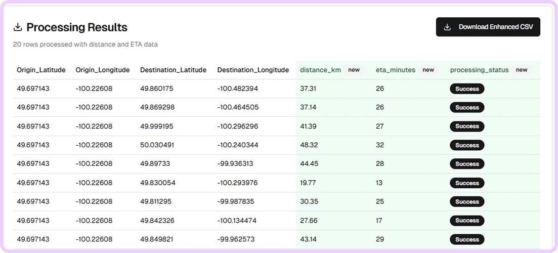
The Distance Matrix Calculator is a browser-based tool that enables users to upload a simple CSV file containing origin and destination coordinates, then instantly compute a distance and ETA matrix between each pair.
The tool leverages the NextBillion.ai Distance Matrix API, renowned for its scalability, accuracy, and flexibility. With support for real-time traffic, vehicle-specific routing (cars, trucks, bikes, pedestrians), and advanced constraint handling, the underlying API powers high-volume routing and logistics operations around the world.
No sign-in is needed for basic usage, and the tool works directly in your browser. Simply upload your file, configure options, and export your results.
Key Features:
- CSV upload support – drag and drop your origin-destination files with automatic header detection
- Multiple travel modes – including car, truck, two-wheeler, and walking
- Traffic-aware results – based on live or historical data
- Export Data – download as CSV for further use in your TMS, CRM or ERP.
How to Use the Distance Matrix Calculator
Step-by-Step Guide:
Step 1: Prepare your CSV file
Your input file should include at least the following columns:
- Origin Latitude
- Origin Longitude
- Destination Latitude
- Destination Longitude
Optional: you can also include IDs or names for each location.
Step 2: Upload the CSV
Go to the Distance Matrix Calculator tool and drag your file into the upload box. The tool will parse your file and preview the data to confirm formatting.
Step 3: Choose travel options
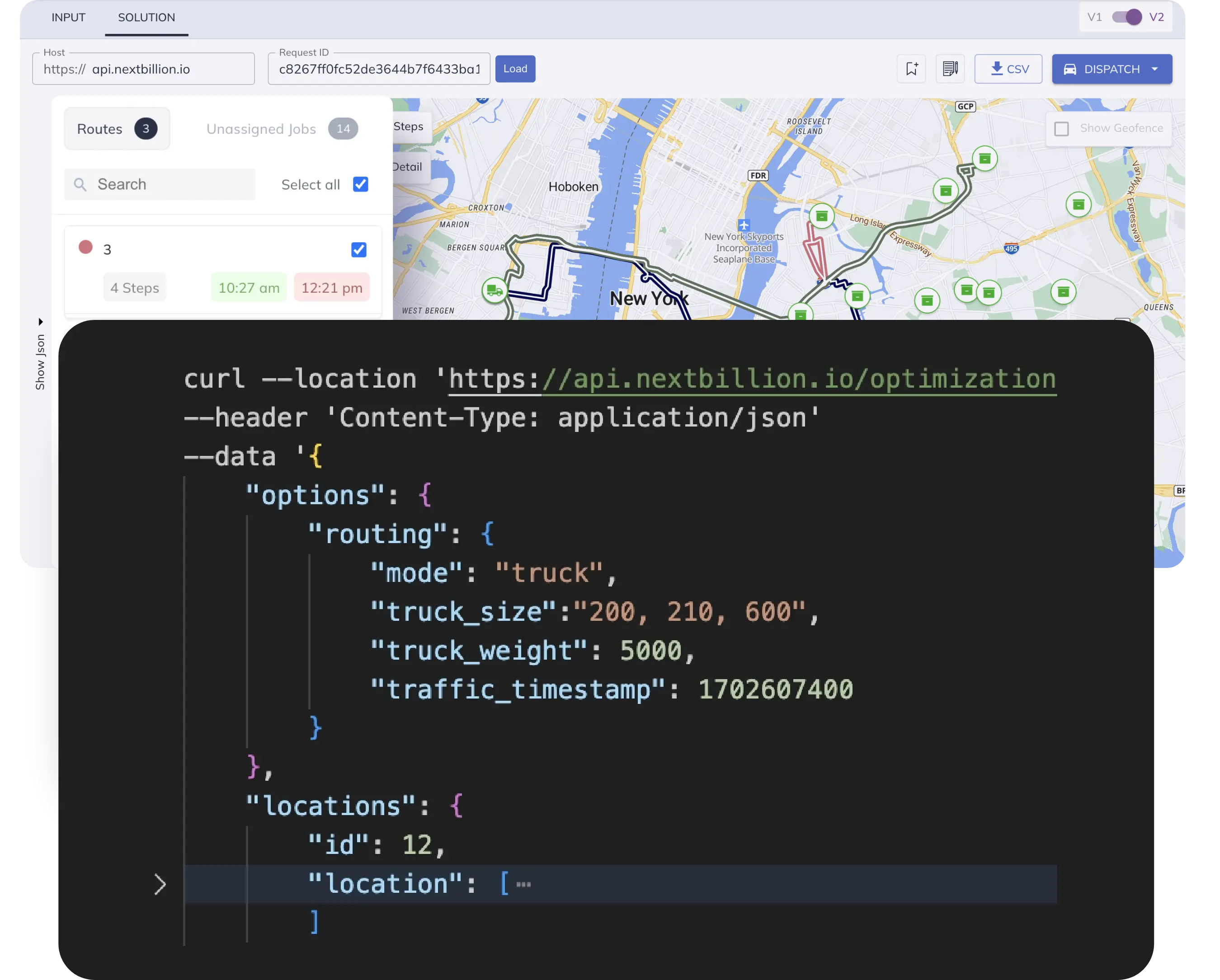
Select your travel mode (car, truck, bike, walk) and choose whether you want to factor in traffic. You can select live traffic (real-time) or typical traffic (based on historical profiles).
Step 4: Start the calculation
Click “Compute Matrix”. The backend will asynchronously process your data using NextBillion.ai’s engine. You’ll see a progress bar or job status tracker depending on the size of your input.
Step 5: Download results
Once complete, download your results in CSV for spreadsheet use or rate-card generation.
That’s it, no setup, no coding.
Real-World Use Cases of Distance Matrix Calculator
The Distance Matrix Calculator supports workflows across logistics, transportation, planning, and analytics:
Logistics & Delivery
- Estimate travel cost between warehouses and delivery zones
- Build efficient linehaul and last-mile pricing matrices
- Identify optimal dispatch clusters based on proximity
Field Services & Home Visits
- Plan technician routes with accurate travel times
- Measure average drive time to each service zone
- Allocate crews based on regional coverage and accessibility
Retail Network Planning
- Determine nearest warehouse/store to each customer
- Optimize catchment areas by drive-time radius
- Compare potential new store locations based on network impact
Urban & GIS Planning
- Build OD matrices for population centers and job clusters
- Model accessibility for various travel modes
- Integrate with isochrone and network analysis tools in QGIS
Transportation & Public Sector
- Simulate network performance under peak/off-peak conditions
- Run regional demand/supply balancing models
- Generate heatmaps of travel-time contours
Why Use NextBillion.ai for Distance Matrix Calculations
The power of the Distance Matrix Calculator comes from its integration with NextBillion.ai’s Distance Matrix API, a battle-tested routing engine built for high-scale, real-time logistics use cases.
Here’s why it stands out:
- High Volume Support – Process up to 50,000 origin-destination pairs in a single async job
- Flexible Travel Modes – Support for car, truck (with dimensions, weight, HAZMAT), two-wheelers, and pedestrians
- Real-Time Traffic Awareness – Live and historical traffic layers for hyper-accurate ETAs
- Enterprise-Grade SLAs – Used by global logistics, retail, and ride-hailing platforms
- Privacy and Compliance – ISO-27001 certified infrastructure, data purging, and region-specific hosting
Whether you’re running a simple site-to-site analysis or a complex truck routing simulation, NextBillion.ai handles scale and complexity with ease.
Conclusion
The Distance Matrix Calculator eliminates the friction in calculating bulk travel time and distance matrices from CSV files. With a fast, no-code interface and enterprise-grade accuracy via NextBillion.ai, it’s perfect for planners, analysts, and logistics teams that need real-world, traffic-aware results at scale.
Whether you’re mapping your next delivery network, modeling access times across a city, or just speeding up your daily planning tasks—this tool does in seconds what used to take hours.
Try it for free today and simplify your workflows – https://tools.nextbillion.ai/distance-matrix-calculator
Frequently Asked Questions
Q1: Can I calculate distances for thousands of locations?
Yes, the tool supports async batch jobs capable of processing up to 50,000 elements (e.g., 500 origins x 100 destinations).
Q2: Do I need to write any code or integrate APIs?
Not at all. The Distance Matrix Calculator is a no-code web interface. Just upload your CSV and click.
Q3: What file formats can I export results to?
Currently, the tool supports CSV (spreadsheet), JSON (developer use), and GeoJSON (for maps/GIS).
Q4: Can I calculate driving times with real-time traffic?
Yes, select “live traffic” mode to use real-time data for ETAs. You can also use “typical” historical traffic profiles.
Q5: Is my data secure?
Yes. All uploaded data is encrypted in transit and automatically deleted after processing. No personal identifiers are stored.
Ready to get started?
Request a DemoTable of Contents
Subscribe to our Newsletters
Get the best practices for route planning & optimization, delivered to your inbox.
Subscribe