


Table of Contents
Artificial intelligence has rapidly evolved from automating basic tasks to powering intelligent decision-making across industries such as healthcare, finance, retail, and manufacturing. The logistics industry is no different. AI is increasingly helping logistics teams plan routes, predict delays, optimize fleet operations, and respond more effectively to complex real-world conditions.
However, when logistics operations are examined at a granular level, generic AI responses are rarely enough. AI needs location-aware context to generate recommendations that are accurate, practical, and aligned with real-world operating conditions.
This is where Model Context Protocols (MCPs) are becoming increasingly important. They connect AI agents with the tools and contextual data required to support location-aware reasoning and operational decision-making.
The updated NextBillion.ai Model Context Protocol (MCP) gives AI coding agents direct access to location intelligence capabilities. Through natural-language instructions, developers can use tools for geocoding, routing, navigation, distance matrices, and route optimization to build applications that reason about addresses, places, routes, travel times, distances, and geographic constraints, accelerating the development and testing of practical location-aware workflows.
In this blog, we will explore how NextBillion.ai MCP can be used to build AI applications that reason about locations, routes, travel constraints, and complex mobility operations.
What Is MCP?
Model Context Protocol (MCP) is an open standard that connects AI applications with external tools, data, and workflows through a consistent interface.
MCP servers expose capabilities as machine-readable tools that AI agents can discover and invoke directly. Unlike static API documentation, MCP enables agents to use services such as routing, geocoding, databases, and workflow execution within real applications.
What Is Location Reasoning in AI?
Location reasoning is an AI application’s ability to understand geographic context and use relationships between real-world locations to make practical decisions.
It goes beyond identifying addresses or coordinates. For example, a delivery location alone does not reveal travel time, vehicle accessibility, or the best stop sequence. Location reasoning adds this operational context by helping AI applications:
- Convert addresses and coordinates into usable locations
- Find nearby places and points of interest
- Calculate road-based distances and travel times
- Determine routes, service areas, and reachable locations
- Sequence multiple stops efficiently
- Account for traffic, closures, vehicle restrictions, and time windows
This matters because geographic proximity does not always mean operational accessibility. One-way roads, restricted turns, bridges, boundaries, and vehicle limitations can make nearby locations difficult to reach.
With location reasoning, AI applications can answer practical questions such as:
- Which driver can reach the customer within 30 minutes?
- What is the best delivery sequence?
- Can this truck safely and legally use the proposed route?
- Which locations are reachable from the depot within an hour?
Location reasoning transforms raw geographic data into actionable intelligence for logistics, mobility, delivery, and field-service operations.
Why AI Applications Need Location Reasoning
Many AI applications do more than generate information. They help people and businesses make decisions that must be executed in the physical world. An AI assistant may identify the next best action, recommend a destination, assign a task, or create a delivery plan. However, completing that action successfully depends on real-world factors such as distance, travel time, road restrictions, traffic conditions, vehicle suitability, operating zones, and the accessibility of a location.
AI can reason about what should happen. Location intelligence helps it determine where and how it can happen. By combining AI with location intelligence, logistics operators can improve efficiency, strengthen decision-making, and deliver more reliable services. Let’s explore how this powerful integration can create value across different industries.
Logistics & Fleet Management
Logistics decisions depend heavily on location, distance, travel time, and operational constraints. An AI application may understand delivery priorities, driver availability, vehicle capacity, and shift schedules, but it needs capabilities such as geocoding, routing, distance matrices, route optimization, and isochrones to determine whether a proposed plan is geographically practical and operationally feasible.
For example, a dispatcher may ask:
- “Which driver should handle this delivery?” Geocoding converts the delivery address into precise coordinates, while a distance matrix compares travel times from multiple drivers to identify the most suitable option.
- “Can these deliveries be completed within the driver’s shift?” Routing and optimization evaluate travel time, service duration, delivery windows, scheduled breaks, and shift limits before recommending an assignment.
- “Build the most efficient route for today’s deliveries.” Route optimization determines the best stop sequence while considering vehicle capacity, customer time windows, driver availability, and other operational constraints.
- “Which customers are within 20 minutes of this driver’s current location?” Isochrones identify all customers or service locations reachable within a defined travel time.
- “Find an alternative route that avoids restricted roads.” Vehicle-aware routing can generate a suitable route based on road restrictions, vehicle dimensions, weight limits, low-clearance bridges, tolls, and temporary closures.
Together, these location-intelligence capabilities allow an AI-powered fleet management application to evaluate real-world conditions and recommend routes, drivers, and delivery plans that are both efficient and executable.
Travel & Mobility
Travel-planning applications need more than information about destinations. They must understand where places are located, how they connect, how long journeys will realistically take, and which options are practical for the traveller. By combining geocoding, places search, routing, distance matrices, route optimization, and isochrones, AI applications can turn general travel preferences into practical itineraries.
For example, a traveller may ask an AI assistant to:
- “Build an itinerary based on travel time.” Geocoding identifies the exact locations of selected destinations, while routing and travel-time calculations help create a schedule that accounts for the time required to move between them.
- “Find attractions along my route.” Places or POI search can identify attractions, restaurants, fuel stations, and other relevant stops within a defined distance of the planned route.
- “Recommend hotels with convenient access to my destinations.” A distance matrix can compare travel times from multiple hotels to planned attractions, offices, airports, or event venues and rank them by overall accessibility.
- “Plan a multi-city trip.” Route optimization can determine an efficient order for visiting several cities while considering distances, estimated travel times, preferred stops, and trip duration.
- “Calculate realistic travel times.” Traffic-aware routing can estimate journey times using the selected travel mode, road network, expected traffic, route restrictions, and departure time.
These location capabilities allow AI travel applications to recommend plans that are not only personalized but also geographically practical, time-aware, and easier to follow.
Field Service
Field service operations require AI applications to balance technician availability with real-world travel conditions. For example, when a dispatcher asks, “Which technician can reach this customer fastest?”, the system cannot answer accurately by comparing straight-line distances alone.
It must geocode the customer’s address, identify the current locations of available technicians, and use a travel-time matrix to compare realistic journey times. It must also verify whether each technician operates within the customer’s service territory and assess how a new job would affect existing appointments.
For multiple service requests, route optimization can determine the most efficient appointment sequence while accounting for service durations, customer time windows, technician shifts, and travel times. This allows the AI application to recommend a technician who can reach the customer quickly without disrupting the rest of the day’s schedule.
E-commerce & Last-Mile Delivery
In e-commerce, location reasoning connects the customer’s checkout experience with the physical delivery operation. AI applications can use geocoding, routing, distance matrices, isochrones, and route optimization to determine whether an order can be delivered, when it will arrive, and which facility and driver should handle it.
For example, an application can:
- Determine delivery feasibility by geocoding the customer’s address and checking whether it falls within an active delivery zone or reachable service area.
- Estimate delivery times using traffic-aware routing, dispatch time, service duration, vehicle type, and current network conditions.
- Assign orders to fulfilment centres by using a distance matrix to compare travel times from available facilities while also considering inventory and processing capacity.
- Define delivery areas using isochrones that show which neighbourhoods or postal areas can be reached within a specified time.
- Optimize delivery routes by sequencing multiple orders based on vehicle capacity, delivery windows, driver shifts, and road restrictions.
Together, these capabilities help AI systems turn customer orders into delivery plans that are both commercially viable and operationally executable.
AI Agents & Location-Based Assistants
AI agents demonstrate one of the clearest opportunities for location reasoning. Consider the following request:
User: “I’m leaving downtown at 5 PM. Find me a restaurant on the way to the airport that adds no more than 10 minutes to my journey.”
A traditional language model can understand the user’s intent and preferences, but it cannot accurately identify the best restaurant using language reasoning alone. It needs location tools to geocode the starting point and airport, calculate a traffic-aware route for a 5 PM departure, search for restaurants along that route, and compare the additional travel time created by each option.
The agent can then exclude restaurants that require a detour of more than 10 minutes and recommend the most suitable choices based on accessibility, cuisine, ratings, opening hours, or other user preferences.
This is location reasoning in action: the language model understands what the user wants, while geocoding, routing, places search, and travel-time calculations determine where and how it can happen.
Build Location-Reasoning Applications with NextBillion.ai MCP
The industry examples above share a common requirement: AI must be able to connect natural-language requests with real-world location data and calculations. Understanding what a user wants is only the first step. The application must also identify locations, calculate routes and travel times, discover relevant places, and evaluate geographic feasibility.
The NextBillion.ai MCP connects AI agents with NextBillion.ai’s location intelligence capabilities through MCP-compatible clients. It exposes location APIs as tools that an AI agent can select and combine based on the user’s request. For example, an agent can geocode an address, search for places along a route, compare travel times, generate an isochrone, and display the result on a static map—all within a single conversational workflow. NextBillion.ai MCP repository
This allows developers to build AI applications that do more than discuss locations. They can generate responses grounded in actual geographic data, road networks, and travel-time calculations.
What Does NextBillion.ai MCP Offer?
NextBillion.ai MCP provides a collection of tools that helps AI applications answer different types of location-related questions:
| Capability | Enables AI to reason about |
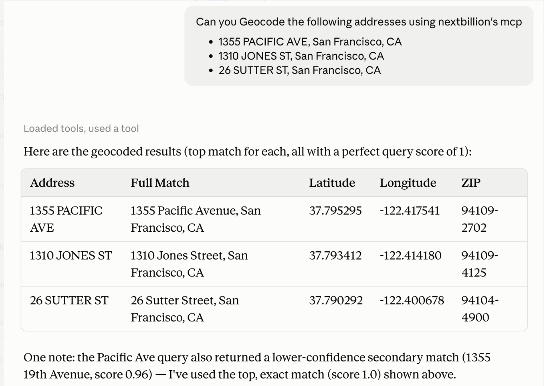
| Geocoding | Converts addresses and place descriptions into precise geographic coordinates. |
| Reverse Geocoding | Converts latitude and longitude coordinates into readable addresses or identifiable locations. |
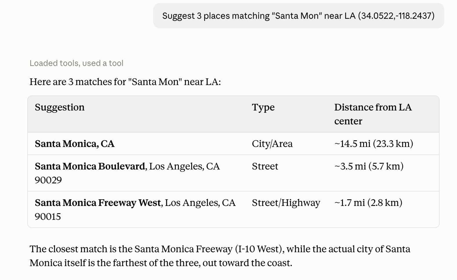
| Autocomplete and Autosuggest | Interprets incomplete, misspelled, or partially entered location queries and recommends relevant matches. |
| Places and POI Search | Finds nearby businesses, landmarks, facilities, and other points of interest, including places located along a route. |
| Routing | Determines how to travel from one location to another using the navigable road network. |
| Distance Matrix | Compares travel times and distances across multiple origins and destinations. |
| Isochrones | Identifies the locations or areas reachable within a specified travel time or distance |
| Static Maps | Creates visual representations of locations, geographic data, and calculated routes |
These capabilities can also be chained together. For example, an AI agent can convert a customer address into coordinates, find nearby service providers, calculate the travel time from each provider, select the most accessible option, and visualize the recommended route. This ability to combine multiple location tools turns a general-purpose AI agent into an application capable of practical location reasoning.
From Natural Language to Location Intelligence
One of the most valuable aspects of NextBillion.ai MCP is its ability to help developers translate natural-language requirements into location-aware application logic.
For example; consider this request:
“Find all warehouses within a 30-minute drive of this location and calculate the fastest route to each.”
To complete this task, the AI agent must do more than understand the meaning of the sentence. It must convert the request into a sequence of location operations:
- Understand the request: Identify the origin, location type, 30-minute travel limit, transportation mode, and required output.
- Select the appropriate tools: Determine that the workflow requires geocoding, place discovery, isochrones, distance-matrix calculations, and routing.
- Geocode the origin: Convert the address or place name into precise latitude and longitude coordinates.
- Find candidate warehouses: Use place search or retrieve warehouse locations from the application’s existing data.
- Identify reachable locations: Generate a 30-minute isochrone and filter out warehouses beyond the reachable area.
- Calculate travel times and routes: Use a distance matrix to compare all candidates and directions to calculate the fastest road route to each warehouse.
- Generate the application logic: Build the code, interface, filtering rules, and result presentation required by the application.
This workflow demonstrates the separation between language reasoning and location reasoning. The language model interprets the user’s intent, NextBillion.ai’s tools perform the geographic calculations, and the application combines the results with its own business rules.
Instead of manually specifying every API call, developers can describe the required outcome. The AI coding agent can then identify the relevant NextBillion.ai MCP tools, determine how they should be combined, and generate the supporting application logic. Explore the available NextBillion.ai MCP tools.
How to Use NextBillion.ai MCP
NextBillion.ai MCP runs locally as a standard input/output—or stdio—server through npx. Once it is configured with an MCP-compatible client, the client can launch the server and make the available location tools accessible to the AI agent.
Prerequisites
Before getting started, developers need:
- A NextBillion.ai API key (Get Free API Key)
- Node.js and npx installed
- An MCP-compatible AI coding agent or client
- Access to the nextbillion-mcp package and GitHub repository
Keep the API key in an environment variable or secret-management system. Avoid committing it to a public repository or exposing it in client-side application code.
Set Up NextBillion.ai MCP
The package can be launched directly through npx, so a global installation is not required.
NBAI_API_KEY=YOUR_KEY npx -y nextbillion-mcp
Replace YOUR_KEY with your NextBillion.ai API key. When NextBillion.ai MCP is added to an AI coding client, the client normally runs this command automatically using the configuration supplied by the developer.
The current package operates as a local studio server. Configuration examples for supported clients are available in the official manual configuration guide.
Connect Your AI Coding Agent
Claude Code
Run the following command in your terminal:
claude mcp add nextbillion –env NBAI_API_KEY=YOUR_KEY — npx -y nextbillion-mcp
Claude Code can then start the MCP server and make its location tools available during the coding session.
Cursor
Add the following configuration to ~/.cursor/mcp.json. To configure it for only one project, use .cursor/mcp.json inside that project.
{
“mcpServers”: {
“nextbillion”: {
“command”: “npx”,
“args”: [“-y”, “nextbillion-mcp”],
“env”: {
“NBAI_API_KEY”: “YOUR_KEY”
}
}
}
}
Reload Cursor after saving the configuration.
Codex CLI
Add the following configuration to ~/.codex/config.toml:
[mcp_servers.nextbillion]
command = “npx”
args = [“-y”, “nextbillion-mcp”]
env = { NBAI_API_KEY = “YOUR_KEY” }
Restart the Codex session so it can load the newly configured MCP server.
Other MCP-Compatible Clients
For another client that supports local stdio MCP servers, configure the following values using the client’s MCP settings format:
{
“command”: “npx”,
“args”: [“-y”, “nextbillion-mcp”],
“env”: {
“NBAI_API_KEY”: “YOUR_KEY”
}
}
After connecting, verify that the client can access NextBillion.ai tools such as geocode_forward, geocode_reverse, place_search, search_along_route, directions, distance_matrix, isochrone, and static_route_map.
Build Your First Location-Aware AI Agents
After connecting the MCP server, give the AI coding agent a clear description of the application you want to create.
Example prompt:
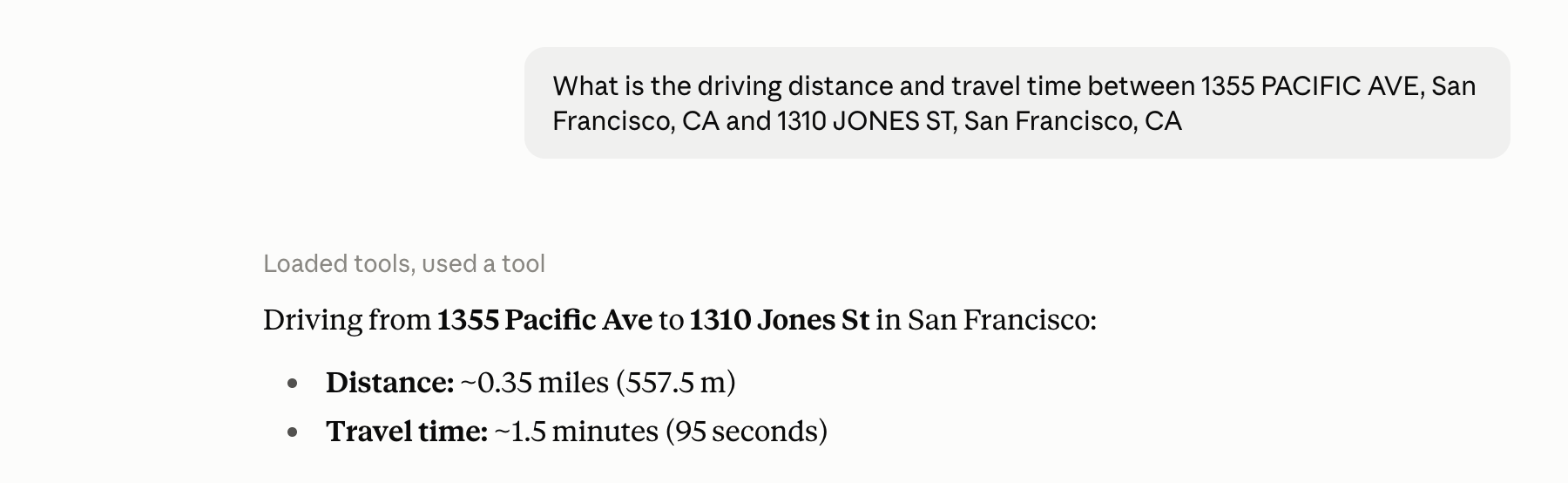
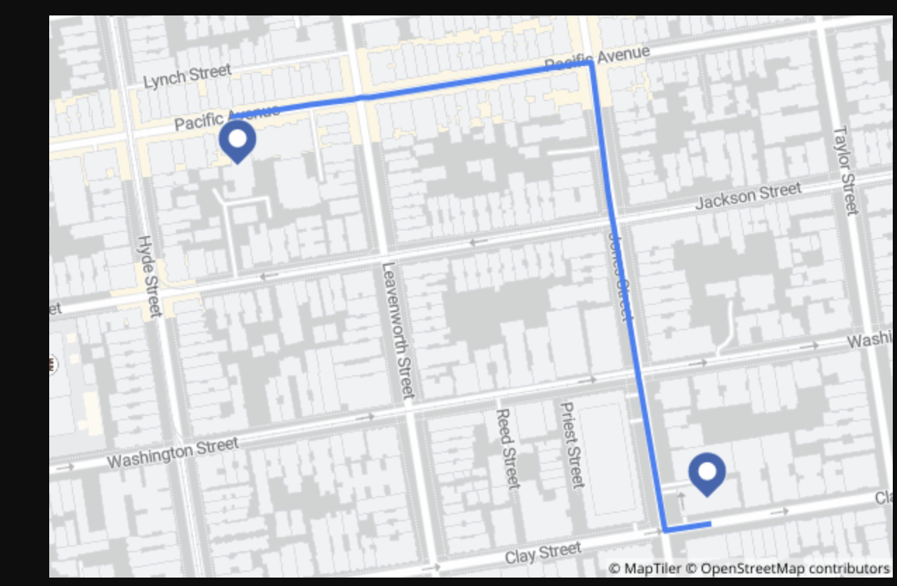
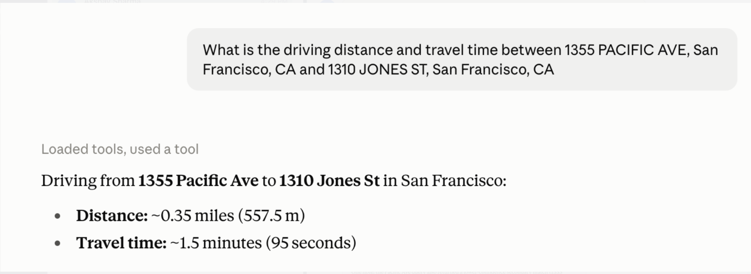
“Build an application that takes an origin and destination, calculates the fastest driving route, and displays the route, distance, and estimated travel time.”
Using NextBillion.ai MCP, the agent can:
- Generate input fields for the origin and destination.
- Use forward geocoding to convert the entered addresses into coordinates.
- Call the directions tool to calculate the driving route.
- Extract the estimated distance and travel time from the result.
- Use the static-route-map tool to produce a visual representation of the route.
- Generate the frontend and backend logic required to display the results.
- Add input validation and error handling for incomplete or invalid locations.
The MCP tools help the coding agent understand and test the required location workflow. In a production application, the NextBillion.ai API key should remain on the server side and never be exposed directly in browser code.
Combining Multiple Location APIs
The value of location reasoning becomes clearer when an application needs to combine several capabilities.
Consider this prompt:
“Build an application that finds restaurants along my route, filters them to those that add no more than five minutes to the journey, and ranks them by additional travel time.”
The AI agent can build this workflow by:
- Geocoding the origin and destination.
- Calculating the original route and baseline travel time.
- Using search-along-route to find relevant restaurants near that route.
- Calculating travel times through each candidate restaurant.
- Measuring the detour created by every option:
Detour time = Travel time via restaurant − Direct-route travel time - Removing restaurants that add more than five minutes.
- Ranking the remaining options by detour time.
- Displaying the original route, selected restaurant, and updated journey on a static map.
This workflow combines routing, places search, distance and travel-time calculations, and maps. Instead of returning an arbitrary list of nearby restaurants, the application recommends locations that satisfy a measurable travel constraint. That is the difference between a basic location search and genuine location reasoning.
Ideas for Location-Reasoning AI Applications
NextBillion.ai MCP can support a wide range of prototypes and AI-driven workflows, including:
- AI route planners: Calculate routes, compare alternatives, and explain travel choices conversationally.
- AI travel assistants: Build practical itineraries and recommend places based on accessibility.
- Delivery planning agents: Evaluate delivery feasibility, travel times, and service coverage.
- Fleet management copilots: Compare vehicle locations and help dispatchers make location-aware decisions.
- Field service assistants: Identify reachable technicians and evaluate appointment travel times.
- Location-based recommendation engines: Recommend businesses or services based on route proximity and detour time.
- Real estate assistants: Compare properties using commute times and accessibility to schools, offices, or amenities.
- Logistics planning agents: Find facilities, compare travel times, and evaluate routes between operational locations.
- Geospatial research assistants: Search, compare, and visualize geographic relationships using natural-language instructions.
- Mobility applications: Calculate routes, reachable areas, and realistic journey times.
- Local discovery assistants: Find relevant businesses, landmarks, or services near a user or along a planned journey.
These applications can also combine NextBillion.ai location tools with internal business data, inventory systems, CRM records, property listings, or operational platforms to deliver more context-specific results.
Build Your Location-Reasoning AI Application
AI is becoming increasingly agentic. It can interpret objectives, select tools, generate code, and coordinate multi-step workflows. However, applications that interact with the physical world need reliable real-world context—and location is one of the most important dimensions of that context.
MCP provides a standardized way for AI agents to interact with external capabilities. NextBillion.ai MCP extends this model with tools for geocoding, place discovery, routing, distance matrices, isochrones, and static maps. Developers can use these capabilities to build AI applications that understand not only what needs to happen, but also where and how it can happen.
Ready to build an AI application that understands the physical world?
- Try NextBillion.ai MCP
- Explore the NextBillion.ai APIs
- Connect the MCP server and build your first prototype
- Contact the NextBillion.ai team for implementation guidance
Ready to get started?
Request a DemoTable of Contents
Subscribe to our Newsletters
Get the best practices for route planning & optimization, delivered to your inbox.
Subscribe