


Route Optimization API
Optimize routing, task allocation and dispatch
Distance Matrix API
Calculate accurate ETAs, distances and directions
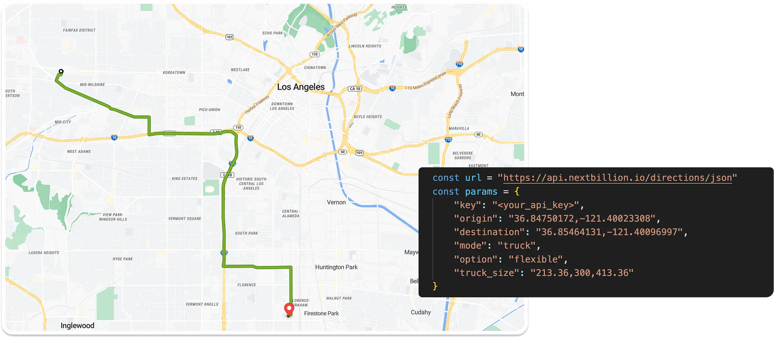
Directions API
Compute routes between two locations
Navigation API & SDK
Turn by Turn Instructions for Drivers & Technicians
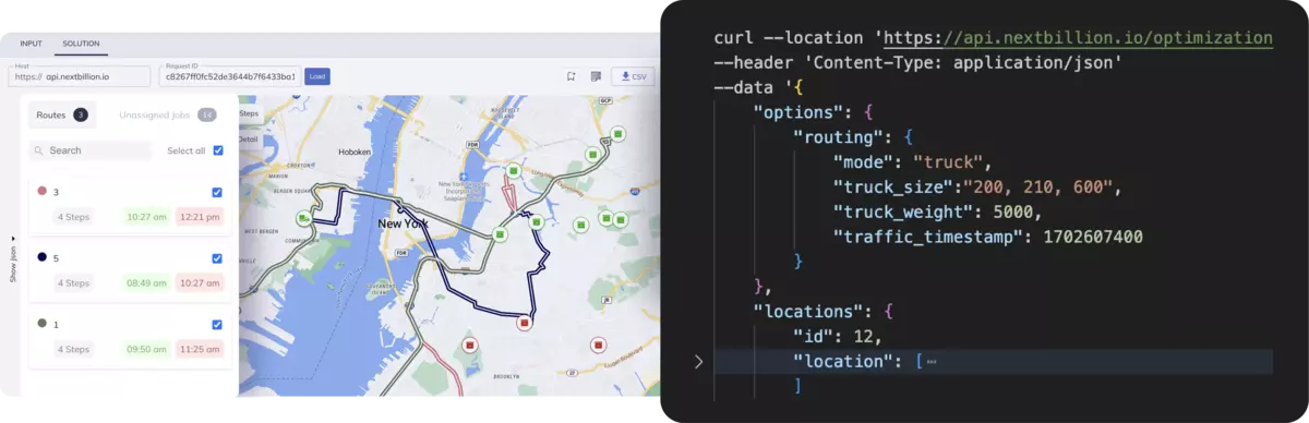
Route Optimization Software
Plan optimized routes with 50+ Constraints
Product Demos
See NextBillion.ai APIs & SDKs In action
AI Route Optimization
Learns from Your Fleet’s Past Performance
Platform Overview
Learn about how Nextbillion.ai's platform is designed
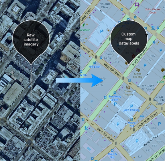
Road Editor App
Private Routing Preferences For Custom Routing
On-Premise Deployments
Take Full Control of Your Maps and Routing
About Us
Our story, vision
and mission
Contact Us
Reach out to us for any product- or media-related queries
Write to us at

Table of Contents
How do applications know exactly where you are when you search for nearby restaurants, book a cab, or track a delivery order in real time? Behind these location-aware experiences lies a technology that allows software to access and interpret geographic coordinates directly from a user’s device.
The Geolocation API enables web applications to retrieve location information such as latitude, longitude, and accuracy data through the browser. Read this blog to understand how the Geolocation API works, the core methods developers use to access location data, and how location-aware applications are built step by step.
TL;DR: The Geolocation API allows web applications to access a device’s geographic location through the browser using standardized JavaScript. With user permission, browsers estimate location using GPS, Wi-Fi, cellular towers, and IP signals, enabling applications to deliver location-aware services.
Key takeaways:
The Geolocation API is a web-based application that enables web applications to retrieve the geographic position of a device using standardized JavaScript. It is defined using the W3C Geolocation API specification and is a standardized method of accessing location information, including latitude, longitude, altitude, speed, and accuracy radius, that is available in modern browsers. After the user grants permission, the browser estimates the device’s location using signals from GPS satellites, nearby Wi-Fi networks, cellular towers, and IP address data. This browser implementation differs from native mobile location services, which communicate with operating system frameworks like Android Location Services or iOS Core Location and are usually more deeply integrated, offering features such as background location tracking.
The Geolocation API provides web developers with the ability to create location-aware applications without the need to develop native applications, despite these differences. Geographic data has become a critical component of modern web applications. It enables services such as navigation, ride-sharing coordination, localized search results, delivery tracking, and contextual recommendations based on a user’s physical location.
Here are the top benefits of using the Geolocation API for building location-aware web applications:
Location information enables apps to customize services based on the geographic location of a user. Web sites can automatically show the restaurants nearby, business listings in the area, local news, weather and store availability. Geolocation is a common feature in e-commerce platforms to tailor the currency, delivery services, and local offers to the location of the user.
The Geolocation API supports applications that require continuous position updates. Navigation platforms, ride-sharing services, and delivery tracking systems rely on live location data to calculate optimal routes, estimate arrival times, and monitor movement. Continuous tracking through methods such as watchPosition() enables applications to update maps and directions as the user moves.
Geolocation information can be mixed with mapping and geospatial systems, like mapping APIs and geographic information systems, by developers. Applications can send browser-retrieved coordinates to mapping services to display maps and calculate the distance between locations. These integrations also help identify nearby points of interest and enable geofencing features that trigger actions when a user enters or leaves specific areas.
Companies that operate transportation and logistics networks, as well as field service teams, rely on geolocation data to organize the work. Live tracking of vehicles assists in assigning tasks to teams according to their location, tracking the progress of deliveries, and enhancing the route planning. These features save fuel, decrease time loss, and enhance the visibility of the operations.
The Geolocation API is natively supported by most modern browsers and can be accessed using simple JavaScript methods such as getCurrentPosition() and watchPosition(). Since the browser does sensor communication and permission control, developers can concentrate on application logic and not on the construction of complex location detection systems. This saves a lot of time in the development process of location-sensitive web applications.
Here is a step-by-step guide to building location-aware applications using the Geolocation API:
The initial step is aimed at the preparation of the application environment so that geolocation features can be used in a reliable manner. Developers should ensure that the client browser has the Geolocation API by ensuring that the navigator.geolocation interface is available. Since location accessibility is limited by modern browsers to secure contexts, the application should also be operated on HTTPS to enable geolocation requests. With these requirements in place, the chances of runtime errors will be avoided, and a safe base will be laid down to access location information.
During this stage, fallback strategies are also put in place by developers in case geolocation support is not available or limited. Applications can also be based on other methods, like IP-based location lookups or manual location entry fields, whereby the user can enter the city or the postal code. The implementation of these fallback mechanisms is to make sure that even in the event that direct device location retrieval is not available, core application functionality is still available.
The second phase focuses on requesting permission from the user to access location information. Due to the sensitivity of geographic data as a type of personal information, browsers have a strict permission model that will not reveal coordinates to any web application. To activate a geolocation request, the browser will show a permission prompt, which will enable the user to grant or refuse access to the location of their device.
Developers have to build this interaction thoughtfully and only seek location access when it is evident that the feature needs it. In case of denial, the application must react gracefully by providing other options, like manual entry of location or approximate IP-based location. Proper management of permission states allows for a better user experience and builds trust.
Once permission is granted, the application retrieves the device’s geographic coordinates using methods such as getCurrentPosition(). This method returns a Position object that contains a coords interface with key attributes including latitude, longitude, altitude, speed, and accuracy radius. These values are an approximation of the geographic location of the device using the positioning signals available.
The accuracy values returned should be checked by the developers before the coordinates are used in application logic. The accuracy field represents the range within which the real location of the device should lie. This data is used to decide if the location that has been retrieved is accurate enough to be used in the desired feature of the application.
Once the geographic coordinates have been retrieved, the application then processes the location data to come up with meaningful outputs. Reverse geocoding services are frequently used by developers to translate the latitude and longitude values into a readable place name, e.g., city, region, or postal code. Geographic calculations can also be performed using the coordinates, such as the distance between two places.
The stage may involve the integration with mapping services, including Google Maps, Mapbox, or OpenStreetMap. Mapping APIs enable the application to map user position, show markers, calculate routes, and find points of interest around. With the help of geolocation data and mapping tools, the applications can convert raw coordinates into interactive and user-friendly location interfaces.
The last stage is dedicated to the implementation of such sophisticated features as continuous tracking and system optimization. Applications that need real-time movement updates utilize watchPosition() method, which is an effective method to track the movement of the device across time. The feature is typically applied in navigation systems, ride-sharing applications, delivery tracking applications, and fitness tracking applications.
The developers are also required to streamline the performance and the use of resources within the system at this stage. The use of continuous location monitoring can raise battery power as well as network traffic particularly when high-precision GPS sensors are applied. The use of effective tracking intervals, error management and protection of privacy would make sure that the application is reliable and provides real-time location-based functionality.

The following are some common challenges developers face when implementing Geolocation APIs in real-world applications.
Here are some real-world applications where the Geolocation API enables location-aware functionality:
Here are the best practices for implementing the Geolocation API in production-ready web applications:
Request Location Only When Necessary: An application should only request access to location when the feature needs geographic information. Requesting permission to access location as soon as the page is loaded can lead to a decrease in user trust and an increase in the chances of refusing permission.
Clearly Explain Why Location Is Needed: A clear explanation enhances the possibilities of permission being granted by users. Applications must notify users how their location will be utilized, whether it is locating nearby services or enhancing navigation.
Use Appropriate Accuracy Settings: The enableHighAccuracy option should be used only when high precision is required. High accuracy mode enables the use of GPS sensors that consume more battery and can take more time to return results. Network-based positioning may be adequate for general location-based content.
Implement Fallback Mechanisms: Alternative options in case of geolocation failure should be included in the application. Developers usually provide the option of manually typing in a city or postal code where location retrieval is not available or when the user is denied access.
Handle Errors Gracefully: Developers should implement appropriate error callbacks to manage cases like denial of permission, unavailability of location, or request timeouts. Delivering clear messages assists users in comprehending the problem and taking corrective measures.
Here is how NextBillion.ai helps developers build scalable location-based applications using advanced mapping and geospatial APIs:
NextBillion.ai offers a full range of mapping and navigation APIs that are used by developers who create location-based applications. Examples of services supported by these APIs include route optimization, distance calculation, turn-by-turn navigation and map visualization. These capabilities can be implemented in logistics platforms, delivery systems, ride-sharing services, and fleet management applications by developers to process geographic data at scale.
The route optimization technology is one of the main strengths of NextBillion.ai. The platform allows companies to find the best route with many stops, considering factors like traffic, car limitations, delivery priorities, and geographic limitations. Logistics providers and transportation platforms have extensively utilized this ability to minimize fuel usage, minimize delivery time and enhance efficiency in operations.
NextBillion.ai is also geospatial analytics friendly as developers can process large amounts of location data and tailor mapping solutions. Organizations can develop geofencing infrastructure, track vehicle movements, observe geographic trends, and incorporate location intelligence in enterprise processes. This flexibility enables companies to create highly diverse location-aware applications which are industry-specific, like logistics, mobility and supply chain management.
The Geolocation API offers a standardized and easily available method of incorporating geographic awareness into web applications. Using the browser interfaces to retrieve the coordinates of the devices, applications can provide navigation systems, delivery tracking, localized search results, and real-time location tracking. With appropriate permission management, privacy protection and performance management, Geolocation API enables developers to create trusted location-sensitive experiences without involving native mobile development.
Explore NextBillion.ai to power your applications with advanced mapping, routing, and location intelligence APIs built for scalable geospatial solutions.
The Geolocation API provides geographic coordinates such as latitude, longitude, accuracy radius, time stamp and in some cases altitude, speed and heading based on the device sensors. This information assists applications to identify the approximate physical location of the user and construct location-based features.
The majority of modern browsers are compatible with the Geolocation API, such as Chrome, Firefox, Safari, and Edge. Nevertheless, geolocation is often only accessible via a secure HTTPS connection and user authorization prior to location data being accessed.
The device relies on the positioning technique to be accurate. The positioning of GPS can give accuracy within a few meters when outside whereas Wi-Fi and cell tower positioning can give less accurate results, particularly when inside or in locations with weak signals.
The getCurrentPosition() method retrieves the device’s location once at the time of the request. In contrast, watchPosition(), on the other hand, constantly tracks the position of the device and updates it whenever the location changes, which is helpful when real-time tracking is required.
Browsers ask permission as geographic location is regarded as sensitive personal information. The permission prompt makes sure that users have control over whether a site can access their location and the use of such information.
Bhavisha Bhatia is a Computer Science graduate with a passion for writing technical blogs that make complex technical concepts engaging and easy to understand. She is intrigued by the technological developments shaping the course of the world and the beautiful nature around us.

