


Route Optimization API
Optimize routing, task allocation and dispatch
Distance Matrix API
Calculate accurate ETAs, distances and directions
Directions API
Compute routes between two locations
Navigation API & SDK
Turn by Turn Instructions for Drivers & Technicians
Route Optimization Software
Plan optimized routes with 50+ Constraints
Product Demos
See NextBillion.ai APIs & SDKs In action
AI Route Optimization
Learns from Your Fleet’s Past Performance
Platform Overview
Learn about how Nextbillion.ai's platform is designed
Road Editor App
Private Routing Preferences For Custom Routing
On-Premise Deployments
Take Full Control of Your Maps and Routing
About Us
Our story, vision
and mission
Contact Us
Reach out to us for any product- or media-related queries
Write to us at

Table of Contents
Ambulance Dispatch Routes for Emergency Care are essential to ensure that ambulances can navigate the quickest and safest route to reach the medical care center. Emergency cases require urgent medical care, and around 33% of patients in road case accidents lose their lives to the late arrival of ambulance and hospital due to traffic jams.
The first hour of an emergency services is the critical hour when a patient needs the necessary medical care to save the patient’s life. With the growing network of roads and traffic instances, it becomes difficult for ambulance drivers to get real-time data about road conditions. If the dispatcher knows which is the shortest route to the nearest hospital/to the patient while considering the real-time traffic conditions, it will become easier to direct the drivers to reach the destination and handle the case.
This is possible when the ambulance fleet is equipped with a robust Ambulance Dispatch route system for Emergency Care. The advanced system is powered by technologies like GPS navigation, AI-powered route optimization, geofencing, and dynamic planning, which help dispatchers select the fastest and safest route to reduce response time.

Emergency response centers play a crucial role in ensuring timely medical assistance during critical situations, such as medical emergencies, fires, and natural disasters. Factors such as traffic congestion, unpredictable road conditions, data accuracy issues, and coordination with multiple agencies contribute to delays that can be a matter of life and death.
Let’s understand the challenges that Emergency Centers face on a daily basis that lead to reduced response times and survival rates:
Besides, the emergency departments may lack instant notifications when a unit reaches or leaves a critical area, causing coordination issues and slower response times.
Geofencing is a location-based technology that creates virtual boundaries around specific geographic areas. When a device or vehicle enters or exits these predefined zones, automated actions, such as alerts or routing changes, are triggered. This technology is widely used in emergency services to improve situational awareness and ensure that responders can reach affected areas as quickly as possible.
Here’s how geofencing helps the emergency responders:
Real-Time Location Tracking for Faster Response
Geofencing allows emergency dispatchers to track the real-time location of response units. This ensures that the nearest available unit can be deployed to the emergency site, reducing delays caused by outdated or manual tracking methods. By integrating GPS and IoT-enabled devices, dispatch centres gain a comprehensive view of response unit locations and movement patterns.
Automating Alerts and Emergency Zone Management
With geofencing, emergency services can automate alerts for first responders, hospitals, and other critical stakeholders when an incident occurs within a defined zone. This automation reduces response time by eliminating manual communication delays. Additionally, geofencing helps manage high-risk zones by automatically rerouting emergency vehicles to avoid hazards or congested areas.
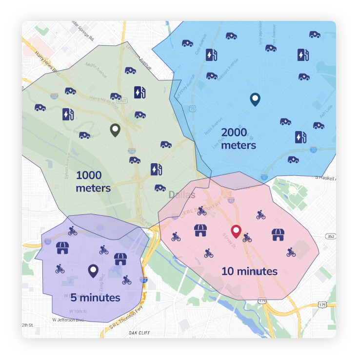
For instance, NextBillion.ai’s Geofencing API helps with effective resource and asset utilization. The responders can assign the nearest hospitals to the emergency responders in real-time with the help of isochrones and isodistances. It helps in calculating the proximity based on time or distance.
It helps monitor the ambulance’s movement and enables notifications and alerts to the hospital team based on the proximity. This helps reduce the waiting times and helps the hospital team to prepare in advance by arranging necessary medical equipment, mobilizing specialized staff, and ensuring a seamless patient handover.
Dynamic planning ensures that emergency response teams can adapt in real-time to changing conditions, such as traffic congestion or unexpected roadblocks. For instance, the NEMT (non-emergency medical transportation) usually deals with non-emergency issues, but the industry deals with time-sensitive scenarios. Appointment rescheduling and vehicle breakdown are some cases that can mimic emergency situations that require a fast response to allocate resources.
This is where dynamic planning comes into play. It helps in enabling automated route adjustments based on congestion, road closures, or weather disruptions. Vehicles received updated directions instantly, ensuring they always took the fastest possible route.
In emergency centers, AI-driven insights and real-time data help the dispatch centres refine routing and unit allocation strategies to enhance efficiency continuously. Here’s how:
AI-Driven Route Optimization
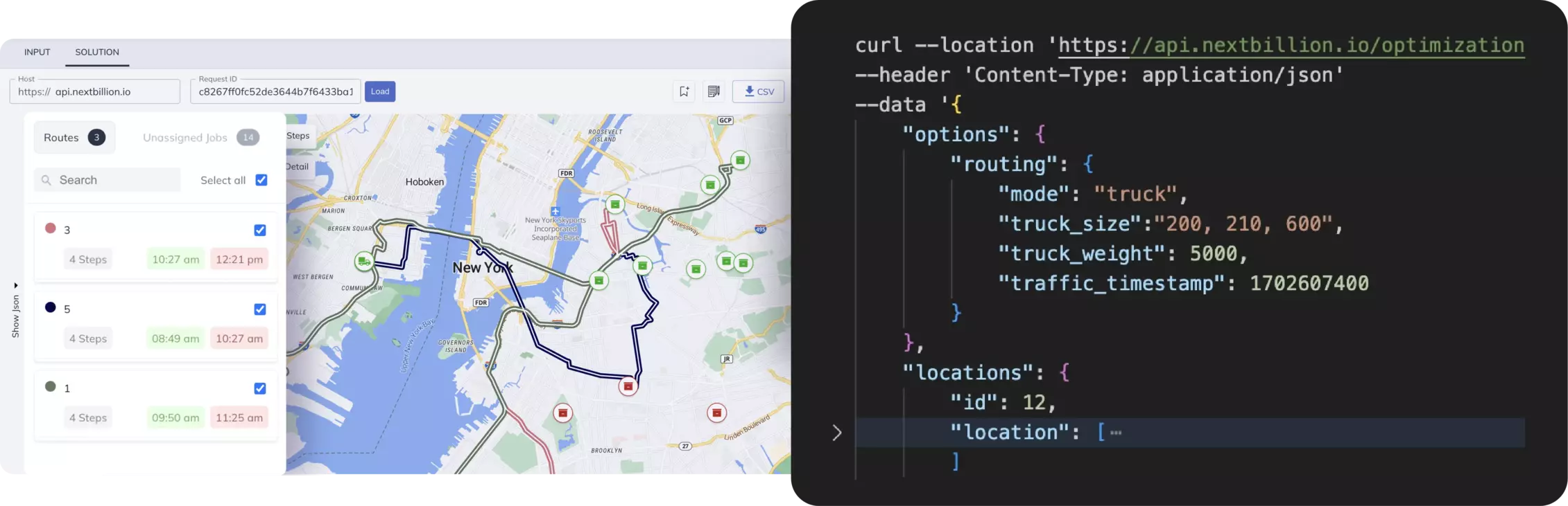
Artificial Intelligence (AI) plays a crucial role in optimizing emergency response routes. AI-powered algorithms analyze traffic patterns, weather conditions, and historical response data to determine the fastest and safest routes. This proactive approach minimizes travel time and maximizes the chances of successful intervention. NextBillion.ai’s route optimization API considers 50+ constraints to dynamically re-route considering the real-time road conditions.
Dynamic Unit Allocation Based on Proximity
Instead of relying on fixed station-based dispatching, dynamic planning enables response units to be allocated based on their real-time proximity to the emergency location. This method ensures that the closest unit is dispatched, reducing response time and optimizing resource utilization.
Continuous Monitoring and Route Adjustments
Geofencing and AI-based systems continuously monitor routes and adjust them dynamically based on new traffic conditions or obstructions. If a faster route becomes available or an existing path is blocked, the system automatically recalibrates, ensuring responders always take the most efficient path.
With increasing urbanization, traditional route planning methods often fail to deliver optimal results. This is one of the issues that an emergency center faces, and it leads to operational inefficiency. The unpredictable road conditions and inefficient route planning impacted the emergency department admissions.
Here are some of the factors that impacted the response time, patient care, and operational efficiency:
Here’s what the organization wanted to accomplish with integration:
The organization partnered with NextBillion.ai’s MapFusion API and SDKs to create a customized dynamic planning solution that helped them overcome the challenges. Here’s how:
The organization witnessed a 30% reduction in emergency response times. Automated routing adjustments and proximity-based unit allocation improved the efficiency of resource deployment. The system also enhanced coordination between emergency responders, hospitals, and law enforcement agencies, leading to better outcomes for patients.
The effectiveness of geofencing and dynamic planning depends on several advanced technologies that enable precise location tracking, intelligent decision-making, and seamless communication.

Global Positioning System (GPS) technology, combined with Internet of Things (IoT) devices, enables precise real-time tracking of emergency response units. IoT sensors installed in vehicles provide continuous updates on location, speed, and route conditions, allowing dispatchers to make informed decisions.

AI-powered predictive analytics analyze historical data and real-time inputs to optimize emergency response strategies. These insights help anticipate demand, suggest alternative routes, and identify potential delays before they impact response times.
Cloud-based platforms enable seamless communication and data sharing among emergency response teams. These systems allow multiple agencies to access real-time updates, ensuring coordinated efforts in large-scale emergencies.
To maximize the benefits of geofencing in emergency dispatch, organizations should follow best practices that enhance accuracy, reliability, and efficiency.
Defining precise geofencing boundaries ensures that automated alerts and response triggers activate only when necessary. This prevents false alarms and ensures that emergency resources are deployed effectively.
By integrating live traffic, weather, and incident reports, emergency dispatch centers can make informed decisions in real time. Live data integration enhances situational awareness and improves response planning.
Emergency systems must be designed with fail-safes and redundancy measures to ensure continuous operation during critical situations. Backup servers, alternative communication channels, and robust cybersecurity protocols help maintain system reliability.
Dynamic route planning is essential for an industry that deals with uncertainties. Unpredictable cases often surround the emergency medical teams, and a robust route planning and geofencing system is required for operational efficiency. The dynamic route planning system helps with faster, more flexible, and highly efficient delivery routes that help the team to reach the emergency incident site and hospital at the earliest.
MapFusion includes a set of suitable APIs and SDKs, making it a one-stop solution for routing, navigation, and tracking. It can easily integrate map data from multiple sources and customize the routes as per the fleet’s needs. The platform is designed for scalability, such that it easily handles massive datasets and API calls, whether managing a city-wide network or nationwide. Connect with NextBillion.ai experts to get more information about MapFusion and how it can be setup.
Bhavisha Bhatia is a Computer Science graduate with a passion for writing technical blogs that make complex technical concepts engaging and easy to understand. She is intrigued by the technological developments shaping the course of the world and the beautiful nature around us.

