
- BLOG
How Route Avoidance Works Under the Hood (Highways, Ferries, Tolls, Zones)
Published: March 16, 2026
Route Optimization API
Optimize routing, task allocation and dispatch
Distance Matrix API
Calculate accurate ETAs, distances and directions
Directions API
Compute routes between two locations
Driver Assignment API
Assign the best driver for every order
Route Optimization Software
Plan optimized routes with 50+ Constraints
Product Demos
See NextBillion.ai APIs & SDKs In action
AI Route Optimization
Learns from Your Fleet’s Past Performance
Platform Overview
Learn about how Nextbillion.ai's platform is designed
Road Editor App
Private Routing Preferences For Custom Routing
On-Premise Deployments
Take Full Control of Your Maps and Routing
Table of Contents
What if the fastest route is not the one you actually want to take? Millions of drivers rely on navigation applications every day, but true intelligence lies not just in finding roads on a map, but also in knowing which ones to avoid. Whether it is bypassing toll fees, steering clear of congested routes, skipping ferries, or avoiding restricted city zones, modern routing systems evaluate geographic, regulatory, and behavioral data in layers before presenting a route. These choices are driven by sophisticated mapping features, graphical algorithms, and rule-based optimization models that transform travel according to user preferences and the real world.
Want to see how these systems make such precise decisions behind the scenes? Read the full blog to understand the technology powering smarter, preference-aware navigation.
Route avoidance is an optimization layer that is part of the advanced GPS routing engines that allow users and fleet operators to avoid certain types of roads, geographies, or travel conditions prior to the system calculating the final route. Instead of using only shortest-distance or fastest-time computations, the navigation engine initially considers set constraints and filters out road segments that do not meet the set constraints. It generates routes aligned with travel behavior, operational priorities, and regulatory factors, making navigation results compliant, practical, and context-sensitive.
Traditional navigation systems were based on the minimization of distance or travel time as the main goal. In reality, though, the choice of traveling is affected by a more extensive group of variables, such as the price of the tolls, the specifics of the vehicle, the safety factors, and the limited-access areas in cities. Route avoidance brings in a more advanced decision model as it takes geospatial metadata, policy-based rules, and cost modeling as part of the routing code.
The purpose of route avoidance is to provide routes that are consistent with realistic travel requirements instead of the shortest paths (mathematically). This includes:
By embedding these constraints early in the calculation stage, navigation systems produce routes that are usable, compliant, and context-aware.
Here are the key features and capabilities of route avoidance technology in modern navigation systems:
Users can define exactly what they want to avoid, such as tolls, highways, ferries, or restricted areas. The system converts these selections into enforceable routing constraints, ensuring the generated path aligns with individual or organizational travel needs.
The navigation databases contain detailed metadata of each road segment, such as access control, pricing hints, vehicle restrictions, and surface classifications. It is structured intelligence that allows accurate filtering prior to the commencement of route computation.
Routing engines do not simply use distance or time; instead, they use weighted penalties on routes that are avoided. This enables the system to make trade-offs smartly, choosing options that are efficient and respect avoidance preferences.
Embedded geofencing identifies congestion areas, emission-controlled regions, or limited corridors. The system automatically diverts vehicles to stay within the local regulations without the need to manually divert them.
Route avoidance can adapt to vehicle type by considering height, weight, clearance, or road suitability. This ensures trucks, buses, and specialized vehicles receive infrastructure-compatible paths.
Live traffic, closures, and environmental data are continuously processed within navigation platforms. When the conditions are altered, the route is recalculated with avoidance rules being followed where feasible.
Standardized avoidance settings can be used by organizations to apply routing strategies across multiple vehicles that can be used to manage cost, safety, and compliance on a large scale.
Here are the key benefits that make route avoidance an essential feature in modern navigation systems:
Route avoidance assists the traveler and the fleet operators in avoiding toll roads, congestion charges, and paid zones. Users can control the cost of traveling without manually comparing all the route options by automatically picking the most cost-efficient options. It is especially useful in the sphere of logistics when the repetitive toll payments can influence the general transportation budgets greatly. It further helps organizations to predict transportation costs more realistically on recurring routes.
Some drivers prefer to avoid high-speed highways, complex interchanges, or poorly lit rural roads. Route avoidance allows safer trips by giving precedence to known or less risky types of roads that are within the comfort zone of the driver and the capability of the vehicle. This causes a more predictable driving environment and less stress when travelling. This customization, in particular, is useful for drivers, local service cars, or the mobility requirements of a certain region.
Most areas have access control on the weight of vehicles, emissions, or even business categories. The route avoidance ensures that the non-compliant roads or areas are automatically avoided by the navigation systems, and the organizations observe the transport rules and regulations and evade penalties, delays, or rerouting at the checkpoints. This saves on the administrative overhead that is involved in checking compliance by hand.
The use of ferries, limited corridors, or congestion pricing areas is avoided, which provides users with more predictable travel schedules. This predictability is critical in the scheduling of deliveries, service appointments, and operations that are time sensitive, and unexpected delays may cause downstream activity. Customer satisfaction is also enhanced by the use of reliable routing, which aids in the accurate estimation of arrival.
Vehicles, buses, or trucks of large size should take into account clearance limits, the quality of the roads, and turning restrictions. The route avoidance removes inappropriate infrastructure like narrow streets or unpaved roads, and the route taken is conducive to the physical and operational requirements of the vehicle. This reduces the chances of vehicle breakages, time wastage in operations, or end-of-day diversions.
The setting of route avoidance is not a preference. It has a direct effect on the interpretation of map data by routing engines, constraint application, and the generation of optimal paths in accordance with user intent. Here are the top applications of route avoidance:

When users prefer not to use highways, the routing engine modifies weight penalties on motorway-class roads detected by tagging digital map attributes. The system also recalculates its paths with secondary and collector roads that are more appropriate to local travel needs than the high-speed corridors are. The application is popular among city commuters, riders of two-wheelers, and service vehicles that enjoy the advantage of controlled speed and easy point of access. The engine does not remove roads but adjusts the weights of the graph to make sure that the destination is reachable even in thin networks.

Ferry avoidance illustrates the processing of multimodal segments in graph-based routing models. The crossings on the ferry are identified as schedule-dependent edges, implying the introduction of wait time and service availability variables. When avoidance is enabled, these edges are not considered in route computation unless they are the sole possible geographic connection. This guarantees continuity of land-based navigation and algorithmic flexibility in coastal or island areas.

Toll avoidance uses cost modeling as a direct route optimization method. The algorithm compares the cost of money with time spent traveling by assigning toll-tagged segments extra penalty values based on pricing datasets. The system then picks options that are efficient and cost-effective. This application is mandatory for logistics fleets and regular commuters who need predictable costs on repeated routes.
Zone avoidance is based on geofencing layers superimposing regulatory boundaries on the navigation maps. Such areas can be congestion pricing zones, environmental control zones, or vehicle-restricted zones. When a calculated route crosses such a polygon, the engine automatically validates rules of eligibility and reroutes non-compliant vehicles. This is essential in order to guarantee compliance with regulations and to sustain continuous navigation in high-density urban areas.
Scenario | Fleets (Operational Focus) | Personal Users (Everyday Focus) | Value Delivered |
Highways | Avoid expressways to manage fuel usage and enable frequent delivery stops. | Skip high-speed roads for easier, less stressful driving. | Routes align with vehicle purpose and driving comfort. |
Tolls | Eliminate repeated toll expenses across large route networks. | Save money on daily commutes. | Cost-optimized navigation without manual planning. |
Ferries | Remove dependency on schedules that disrupt delivery timelines. | Prefer uninterrupted road travel. | Predictable travel with fewer delays. |
Restricted Zones | Stay compliant with emission, weight, or commercial access rules. | Avoid congestion-fee areas in cities. | Automatic regulatory compliance and rerouting. |
Vehicle Constraints | Avoid narrow, low-clearance, or unsuitable roads for trucks. | Skip difficult terrain or unsafe shortcuts. | Infrastructure matched to vehicle capability. |
Time Predictability | Maintain consistent ETAs for supply chain coordination. | Reach destinations on time with fewer surprises. | Reliable, schedule-friendly routing. |
Route avoidance is not a simple toggle. It is supported by geospatial data engineering and algorithmic decision systems that evaluate road characteristics before computing the final path. Below are the foundational technologies that make this possible:
Each road segment within a navigation database has encoded metadata. These features characterize the physical, regulatory, and operational features of that road. Routing engines do not treat roads equally but use these tags to determine which roads deserve to be included or excluded.
Typical Attribute Tags Include:
These features enable the system to filter out unsuitable roads in advance before the calculation of the route. This ensures avoidance preferences are enforced at the data layer rather than corrected later.
Once the map data has been organized, the navigation platforms turn the road network into a mathematical graph model to calculate routes in an efficient manner.
How the Graph Model Works?
Routing algorithms such as Dijkstra or A* search evaluate millions of possible combinations to determine the optimal path.
How is Avoidance Applied?
Avoidance settings do not simply delete roads. Rather, the system changes the behaviour of those roads within the graph:
Example Logic:
When toll avoidance is activated, the routing engine can consider a 10-minute toll road the same as a 25-minute local road by inflating the cost value. The algorithm then automatically chooses the toll-free option without discontinuity of routes.
Why This Approach Is Used?
Here is a step-by-step explanation of how route avoidance works:
The user starts the process by choosing options like “avoid tolls” or “avoid highways.” The navigation engine saves these inputs as routing constraints. For fleet systems, these preferences may come from central policies instead of individual drivers. This makes sure that all vehicles follow the same rules for how to operate.
The system scans its geospatial database, which has metadata for each road segment, including its classification, toll status, surface quality, access permissions, and vehicle restrictions. This structured data helps the engine not only find a road, but also figure out how to handle it in certain routing situations.
The engine doesn’t delete avoided roads right away; instead, it uses rule-based logic. Some segments, like restricted zones, are not counted at all, while others get penalty weights. For example, if there is no other option, a toll road may still be an option, but it will be rated as less favorable because of the extra costs.
The road network is turned into a graph with nodes and edges. Each edge has dynamic weights that change based on things like travel time, distance, regulatory penalties, and real-time conditions. This structure allows routing algorithms to quickly look at a huge number of possible paths.
Advanced shortest-path algorithms find the best way to get from one place to another that meets all the requirements. The engine tries to meet several goals at once, like keeping travel time reasonable while keeping costs low. This is called multi-criteria optimization, and it is necessary to get realistic navigation results.
Before showing the route, the system checks to see if there are any problems with geofenced rules, environmental zones, or infrastructure limits like bridge height or road width. This inspection makes sure that the route that was made is not only the best one, but also legal and safe for the type of vehicle.
The computed route is overlaid with live traffic updates, alerts for temporary road closures, construction, and weather conditions. If these things come into contact with avoidance rules, the system recalculates on the fly to keep the trip efficient and in line with the rules.
The engine keeps an eye on changes in traffic, detours, or new rules once navigation starts. If things change, it recalculates alternative paths while keeping the original avoidance preferences as much as possible. This keeps the system responsive without requiring the user to change settings by hand.
Here is how NextBillion.ai empowers businesses to implement intelligent, constraint-driven routing and navigation at scale:
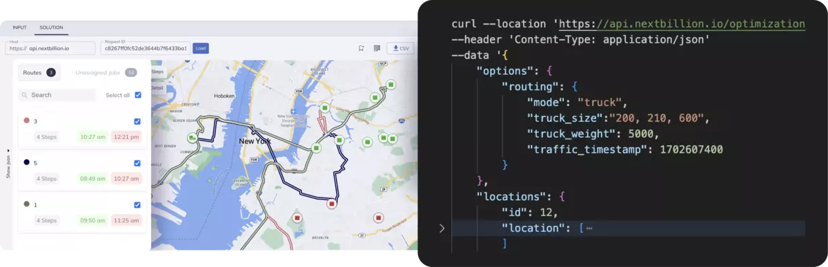
NextBillion.ai provides routing APIs, which enable companies to specify the calculation of routes according to operational principles. Rather than using default navigation behavior, teams can use preferences like limited types of roads, serviceable areas, or vehicle restrictions. It is now possible to apply route avoidance strategies that align with real business processes.

The platform facilitates complex routing conditions that include multi-stop delivery, technician dispatch, and territory-based services. Optimization of routes can be done by considering stop order, service time windows, and operational priorities. It assists organizations in minimizing inefficiencies in traveling as well as in ensuring that the routes comply with the pre-determined routing constraints.
NextBillion.ai makes it possible to route according to vehicle profiles, meaning that businesses can consider such parameters as vehicle size, the type of load, or access eligibility. It makes sure that generated routes do not use infrastructure that might not support some vehicles, which is essential to logistics fleets, last-mile delivery providers, and mobility platforms.
Organizations may incorporate their own map data, or mix various sources of information to represent localized knowledge like individual roads, delivery areas, or areas of operation. Such control can be useful in making sure that routing decisions are made in accordance with what is on the ground instead of just using public data on maps.
The platform is enterprise-friendly and has the proficiency to compute large-scale routing calculations involving a large number of vehicles and destinations at the same time. This enables companies to standardize route avoidance policy and implement it uniformly in distributed operations without bottlenecks in performance.
NextBillion.ai provides developer tools that allow teams to integrate routing, navigation, and ETA calculations directly into their own applications. Businesses can create customized navigation interfaces for drivers, delivery agents, or field teams while maintaining full control over routing logic.
The concept of route avoidance has transformed modern navigation from simple pathfinding into an intelligent decision-making system. Through geospatial intelligence and rule-based optimization, coupled with real-time data processing, navigation platforms provide routes that are responsive to operational requirements, regulatory requirements, and user preferences.
Both in terms of large-scale fleet logistics and in terms of enhancing daily travel, this ability can make journeys not only efficient but also viable and in line with real-world circumstances. The role of route avoidance in facilitating safer, cost-conscious, and context-driven navigation experiences keeps increasing as mobility ecosystems become increasingly more complex.
Looking to build smarter, customizable routing solutions? Explore how NextBillion.ai empowers businesses with advanced mapping, routing, and location intelligence to create precision-driven navigation experiences.
Yes. When certain road types are excluded, the system recalculates with alternative networks, which can add a little distance or time. The routing engine trades off this to ensure efficiency without violating user-imposed constraints.
No. The majority of the platforms use weighted penalties rather than removing roads completely. This makes sure that routes are not blocked because of limited options, particularly in the countryside or geographically restricted regions.
They are based on constantly refreshed map data, local ordinances, and real-time sources of data. Such updates enable systems to include new rules of access that have been enforced, modifications of infrastructure, or temporary restrictions.
Absolutely. It allows drivers to avoid limited districts, small streets, or busy routes in the city, and cost planning, infrastructure appropriateness, and predictable paths over long distances.
Yes. Fleet platforms commonly set centralized routing policy by vehicle type, delivery priorities, or compliance needs, whereas individual users commonly change their preferences in their navigation apps.
Bhavisha Bhatia is a Computer Science graduate with a passion for writing technical blogs that make complex technical concepts engaging and easy to understand. She is intrigued by the technological developments shaping the course of the world and the beautiful nature around us.