


Table of Contents
In the world of location-based services, route optimization, and mapping, working with geographic coordinates and encoded paths is a daily necessity. To make this process easier and more accessible, we are excited to introduce our latest free and developer-friendly Polyline Encoder and Decoder Tool .
Whether you are building routing applications, analyzing delivery patterns, or visualizing spatial data, these tools offer a simple and efficient way to convert between coordinate points and encoded polyline strings.
In this blog, we will explore what these tools are, how they work, who they are for, and the value they bring across industries.
Behind the Scenes of Navigation: Meet the Polyline Encoder & Decoder
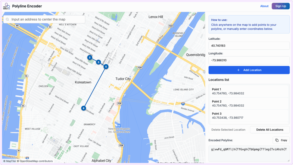
Let’s start with the basics. A polyline encoder and decoder is a tool or algorithm that takes a compact, encoded string representing a geographic path (commonly called a polyline) and converts it back into the original list of latitude/longitude points.
This decoding process allows mapping services and developers to reconstruct detailed routes or shapes from a significantly smaller data footprint.
Why Polyline Decoding Matters?
If you are planning to embrace the polylines in your routing experience, here are a few key benefits you should know about it.
Efficient Data Handling
With Polyline encoder and decoder, you can easily convert compact encoded strings into readable coordinates, reducing the payload size while using APIs.
Smart Route Visualization
Create plots of detailed paths and routes on the map with minimal data overhead with the implementation of Polyline encoder and decoder.
Flawless Interoperability
Users can easily share, store or display geospatial data across platforms with the help of polyline encoder and decoder.
Faster Load Times
With the Compressed data available in the tool, you can easily and quickly transmit and render the data on any of the required devices. Devices such as smart phones or devices with low-bandwidth networks can also get the data in no time.
Debugging & Testing
The tool not only helps in sharing data across platforms but also helps the developers to inspect route outputs from mapping APIs and quickly fix any issue if available.
Works with Multiple Tools
Another added advantage of the polyline encoder and decoder is that it is easily compatible with popular libraries and services across JavaScript, Python, and more.
In short, polyline encoders and decoders aren’t just technical utilities but are the enablers of speed, efficiency, and scale for businesses that live and breathe location data.
Which Teams Need Polyline Support the Most?
Whether you are optimizing deliveries, visualizing routes, or scaling a location-based product, polyline encoding and decoding are crucial tools for the following roles:
Head of Engineering / VP Engineering
The tool helps to optimize performance and scalability by reducing data load across the systems. It ensures faster routing, lower API costs, and seamless integration with mapping services.
Product Managers (especially in Mobility, Logistics, or Mapping Apps)
With the tool, product managers can prioritize route accuracy, user experience, and performance across mobile and web platforms.
Logistics & Operations Managers
It provides a clear view of routes, helping monitor fleet movement, reruns, and delivery patterns in real time. It enables smarter route audits, efficiency tracking, and operational decision-making at scale.
CTOs / Founders
It enables faster, lighter, and more cost-efficient routing infrastructure. They support scalability, real-time visibility, and seamless integration with mapping and dispatch systems.
Industries That Benefit from Polyline Encoding & Decoding
- Logistics & Supply Chain: They can get advantage of efficient route planning, fleet tracking, and delivery optimization.
- Food & Grocery Delivery: It is used to display real-time driver paths, reduce API costs, and enhance user experience.
- Ride-Hailing & Taxi Service: For accurate pick-up/drop-off routing and live vehicle location rendering
- E-commerce & Last-Mile Delivery: To streamline fulfillment, enable real-time tracking, and manage reruns.
- Mapping & Navigation Solutions: For compact route storage and smoother map visualizations.
- Field Services & On-Demand Workforce: To assign and track field agents with optimized and visible routes.
- Geospatial Analytics & AI Companies: For turning compressed location data into actionable insights.
- Urban Mobility & Smart City Initiatives: For analyzing traffic flow, public transport movement, and route planning.
- Logistics Tech & SaaS Platforms: To offer efficient geolocation features in their core products.
How to Use Polyline Encoding & Decoding?
The adoption of Polyline encoder and decoder tool is quick, easy and can be done by simply following a few simple steps:
- Get Your Coordinates: Collect the series of latitude and longitude points (e.g., route waypoints or vehicle paths).
- Encode the Polyline: Use a polyline encoder tool or library (like Google’s Polyline Encoder or NextBillion.ai’s tool) to convert the list of coordinates into a single compressed string.
- Transmit or Store the Encoded String: This string can be sent via APIs, stored in databases, or embedded in URLs, compact and clean.
- Decode When Needed: Use a polyline decoder (like NextBillion.ai’s Polyline Decoder) or in-code functions to convert the string back into points.
- Visualize or Process: Plot the decoded coordinates on a map or use them in analytics, routing logic, or delivery tracking systems.
Get Started with Polyline Encoder & Decoder Tool
Polyline encoding and decoding might seem like a behind-the-scenes utility, but their impact on performance, scalability, and user experience is anything but minor.
Whether you are building routing systems, optimizing logistics, or visualizing live location data, polylines offer a compact, efficient, and universally supported way to work with geographic paths.
For tech teams, ops managers, and product leaders alike, mastering polylines is a small step that leads to smarter, faster, and more scalable location-based solutions.
Free Polyline Encoder by NextBillion.ai
Free Polyline Decoder by NextBillion.ai
Frequently Asked Questions
What is a polyline in route planning?
A polyline is a connected series of geographic coordinates (latitude/longitude pairs) that represent a route, shape, or boundary on a map. In route planning, it’s commonly used to draw the visual path between two or more locations.
Why is polyline encoding used in routing APIs?
Encoding a polyline compresses route coordinates into a short ASCII string, reducing payload size and improving API efficiency. This is essential when transmitting long routes via GET requests or storing paths compactly.
How does polyline encoding work?
Polyline encoding works by delta-encoding lat/lon changes, applying zigzag encoding to handle negatives, and converting the result into a variable-length character string using printable ASCII characters. This creates compact, URL-safe output.
What’s the difference between polyline and GeoJSON?
A polyline is a compact string representation of a route, while GeoJSON is a verbose, structured JSON format used for geographic data. Polylines are smaller and ideal for fast transmission, while GeoJSON offers richer metadata.
What precision level is used in Google-style polylines?
Standard polyline encoding uses 5 decimal places of precision, equivalent to scaling coordinates by 100,000 before encoding. Some APIs (like polyline6) use 6 decimal places for higher accuracy.
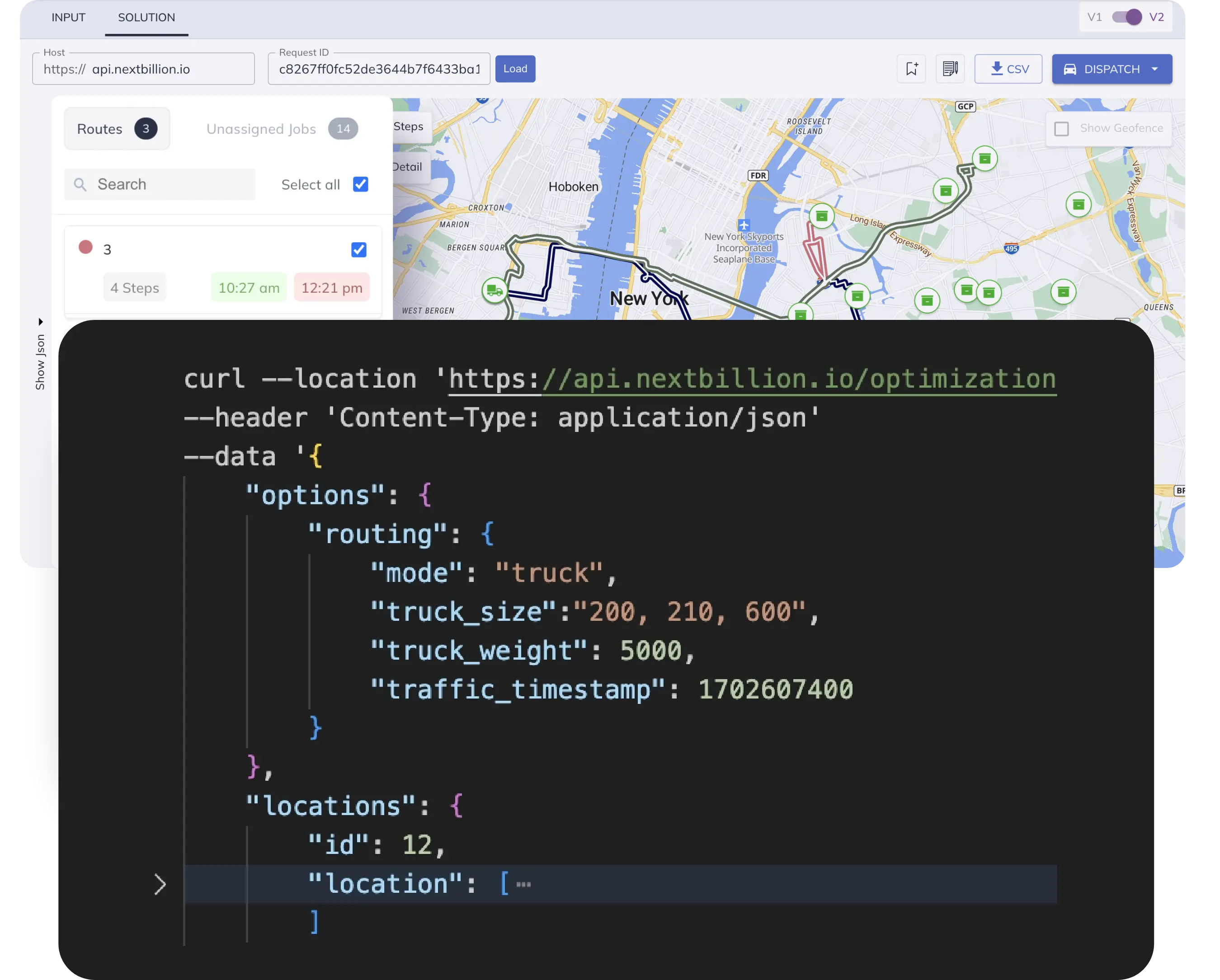
Can polyline encoding handle truck routes in the U.S.?
Yes, polyline encoding can represent any vehicle type’s path, including trucks. The encoded string simply reflects the path, while truck-specific constraints (weight, height, HAZMAT, etc.) are applied during route generation—not during encoding.
Are U.S. addresses or ZIP codes encoded in polylines?
No, polylines encode geographic coordinates—not addresses or ZIPs. If you input U.S. addresses, the routing engine first geocodes them to lat/lon before generating and encoding the route path.
How do I decode a polyline to get coordinates in the U.S.?
Use any standard polyline decoder to convert the encoded string into a list of latitude and longitude pairs. These coordinates are universal, including U.S. locations.
Does live traffic in the U.S. affect the polyline?
Yes, if traffic is considered in route calculation, the resulting polyline may take alternate roads. However, the encoding itself doesn’t store traffic—only the final path that was chosen considering traffic data.
Which routing APIs for the U.S. return encoded polylines?
Popular APIs like NextBillion.ai, OSRM, and TomTom all return encoded polylines in their route responses. These can be decoded for map rendering or further analysis.
Is polyline encoding reversible?
Yes, polyline encoding is fully reversible. The decoding algorithm restores the original list of lat/lon points (to the same level of decimal precision used during encoding).
Ready to get started?
Request a DemoTable of Contents
Subscribe to our Newsletters
Get the best practices for route planning & optimization, delivered to your inbox.
Subscribe