


Table of Contents
You should use “Avoid Tolls” when reducing out-of-pocket costs is more important than minimizing travel time and when a practical non-toll alternative exists. The setting works best in regions with dense road networks where free highways or arterial roads can serve as substitutes.
In these situations, the time trade-off is predictable and manageable.
For drivers who travel the same route every day, toll charges can accumulate quickly. Even small per-trip fees add up over weeks and months.
If the non-toll route increases travel time by only a few minutes, the cost savings may outweigh the delay. This is especially relevant in cities where parallel service roads run alongside toll highways.
Fleet operators often measure performance using cost-per-mile or cost-per-stop metrics. Avoiding tolls can reduce variable expenses across high-volume operations.
However, fleet managers must balance toll savings against:
In cost-sensitive deliveries where timing is flexible, enabling toll avoidance can improve margin control.
Long-distance travelers looking to reduce overall trip expenses may prefer toll-free routes. While the journey may take longer, the savings can be significant across multi-state travel corridors.
This approach works best when:
In many rural and suburban areas, toll roads are limited or optional. Enabling “Avoid Tolls” in these regions typically results in minimal travel disruption because free road infrastructure is widely available.
In such environments, the setting functions predictably and rarely forces major detours.
Use “Avoid Tolls” when:
If time sensitivity is high such as airport transfers, emergency trips, or tight delivery windows the trade-off may not justify enabling the setting.
Scenario | Toll Route | Avoid Toll Route |
Distance | Shorter | Longer |
Travel time | Faster | Slower |
Fuel usage | Lower | Higher |
Monetary cost | Higher | Lower |
You should not rely solely on “Avoid Tolls” when arrival time, regulatory compliance, or infrastructure constraints matter more than cost savings. In these cases, the trade-off between toll avoidance and route efficiency can introduce delays, uncertainty, or operational risk.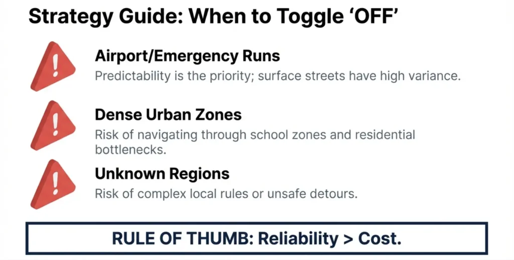
The feature is a preference, not a guaranteed routing rule.
In dense metro areas, toll highways often function as primary traffic relievers. Avoiding them may redirect you to:
In peak hours, the non-toll alternative can significantly increase travel time. For city driving where predictability matters, toll corridors may provide more consistent ETAs.
Some regions use congestion pricing or time-based toll systems. Charges may vary by:
Navigation apps such as Google Maps and Apple Maps may simplify these complex pricing models. If the toll only applies during certain hours, the system might either avoid it unnecessarily or fail to account for temporary charges.
When traveling across countries or unfamiliar jurisdictions, toll logic can differ widely.
If you are heading to an airport, hospital, or scheduled appointment, travel time reliability should take priority over small toll savings.
Avoiding toll highways may introduce:
In time-sensitive situations, the fastest predictable route—toll or not—is usually the safer option.
In some areas, toll roads are the main long-distance connectors. Alternatives may involve:
In these environments, enabling “Avoid Tolls” can produce routes that are technically valid but operationally inefficient.
Do not depend on “Avoid Tolls” when:
In such cases, review the full route preview and estimated time impact before committing to the setting.
Criteria | Consumer Navigation | Fleet Operations |
Tolerance for delay | Moderate | Low |
Cost sensitivity | Personal preference | Operational KPI |
Limited | Configurable via APIs | |
Compliance control | Minimal | Required |
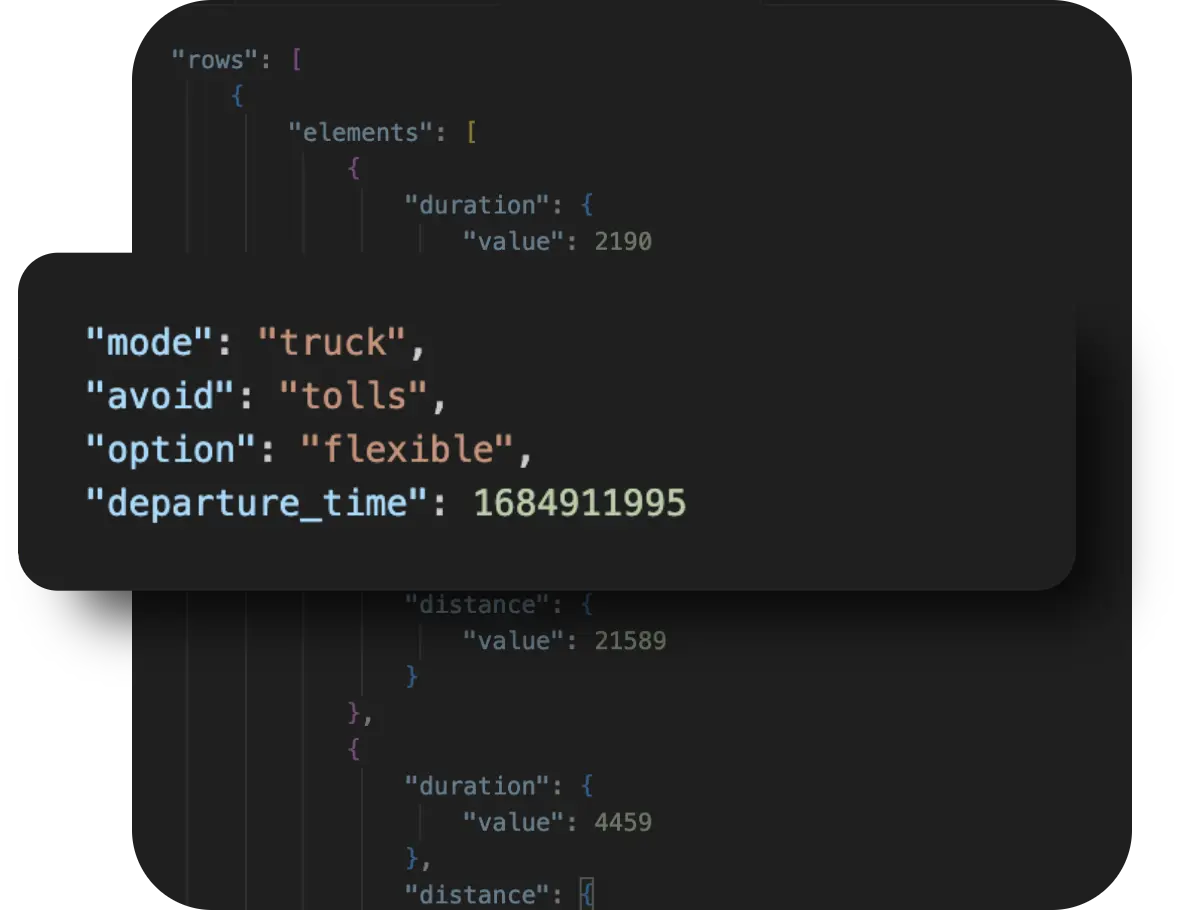
Enterprise routing engines treat toll avoidance as a configurable routing constraint within a broader optimization framework. Unlike consumer navigation apps, where “Avoid Tolls” is a simple toggle, enterprise APIs let developers and operations teams define how toll avoidance interacts with other variables, such as vehicle type, cost models, multiple stops, and business rules.
This configurability helps fleets and logistics platforms balance cost, compliance, and performance based on real-world operational needs.
Enterprise APIs can optimize routes for multiple vehicles at once, considering toll preferences across an entire fleet rather than just a single trip. This means the system can decide that certain vehicles should use toll roads when it benefits overall performance, while others avoid them to reduce costs—based on constraints you set.
NextBillion.ai’s Route Optimization API supports large multi-vehicle routing problems with configurable constraints such as toll avoidance for specific vehicle groups or regions. Planners can define different avoidance preferences per routing profile in the same optimization request.
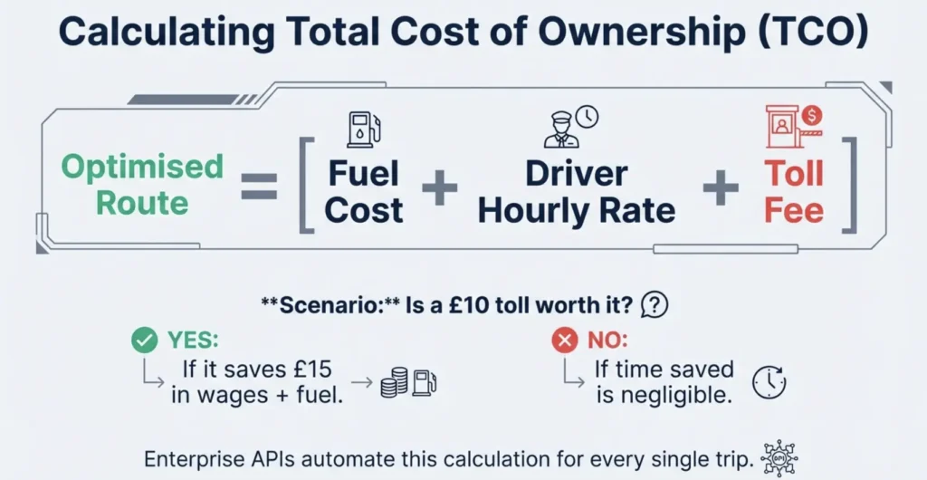
Rather than treating toll avoidance in isolation, enterprise solutions incorporate cost modeling that includes multiple expense types, such as fuel, tolls, driver hours, and more, to compute the best overall solution.
With NextBillion.ai, you can define custom cost matrices or objectives to weigh tolls against other cost factors. This lets the optimizer choose routes that align with your business’s total cost priorities, not just the lowest toll spend.
Toll systems vary by jurisdiction; some use dynamic pricing, time-based charges, or exemptions for vehicle classes. Enterprise APIs allow you to enforce region-specific rules within the routing logic.
NextBillion.ai’s platform includes advanced constraint handling that lets you apply toll avoidance selectively based on region, vehicle type, or time window, ensuring compliance with local toll systems and business policies.
Beyond a simple “yes/no” for tolls, enterprise APIs let you customize how toll avoidance should behave:
NextBillion.ai’s suite supports more than 50 constraints, enabling granular routing preferences such as “avoid tolls for heavy trucks but not for light vans” or “avoid tolls only outside peak hours.” This spreads decision logic across the entire optimization, giving developers fine-grained control.
For businesses that depend on predictable costs, regulatory compliance, and scalable operations, treating toll avoidance as part of a wider constraint set ensures routing decisions align with both economic and operational goals. Enterprise routing APIs like NextBillion.ai’s Route Optimization API enable this level of flexibility and control, making them suitable for logistics, field services, and delivery fleet use cases.
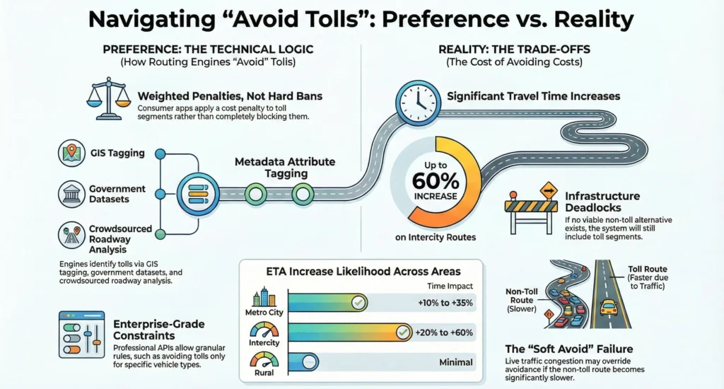
In many cases, yes. Avoiding toll highways often redirects traffic to local roads, arterial streets, or secondary highways. These routes typically have lower speed limits, more intersections, and higher congestion exposure, leading to longer travel times.
Toll roads are usually designed for faster, uninterrupted movement. When you opt out of them, you trade cost savings for reduced speed and predictability.
When “Avoid Tolls” is enabled, the routing engine may:
Even if the distance difference is small, stop-and-go conditions can significantly extend the arrival time.
The time increase varies depending on geography and road infrastructure.
In cities, toll expressways often bypass dense traffic corridors. Avoiding them typically means:
The impact may be moderate during off-peak hours but more pronounced during rush hour.
On long-distance routes, toll highways are often the primary high-speed connectors. Avoiding them may require:
Over longer distances, even small speed reductions compound into significant time increases.
In some regions, toll highways are the only practical connectors between major destinations. In such cases:
Here, the time impact can exceed reasonable thresholds, making toll avoidance operationally inefficient.
Avoiding tolls is fundamentally a cost-versus-time decision:
For casual travel with flexible schedules, the increase may be acceptable. For time-sensitive trips or commercial operations, the delay can outweigh the toll savings.
Area Type | ETA Increase Likelihood |
Metro city | High |
Suburban | Moderate |
Rural | Low (limited tolls) |
“Avoid Tolls” is a useful setting, but it is not a guarantee. It works by adjusting how routing engines prioritize road segments, not by completely eliminating toll roads from consideration.
In regions with strong alternative infrastructure, the feature can help reduce recurring costs. In dense cities, time-sensitive trips, or areas with limited road options, it may increase travel time or still include toll segments.
Understanding how toll metadata, traffic conditions, and routing algorithms interact allows you to make better decisions. Whether you are a daily commuter or managing fleet operations, the key is to weigh cost savings against reliability, ETA impact, and operational goals before relying on the setting.

