


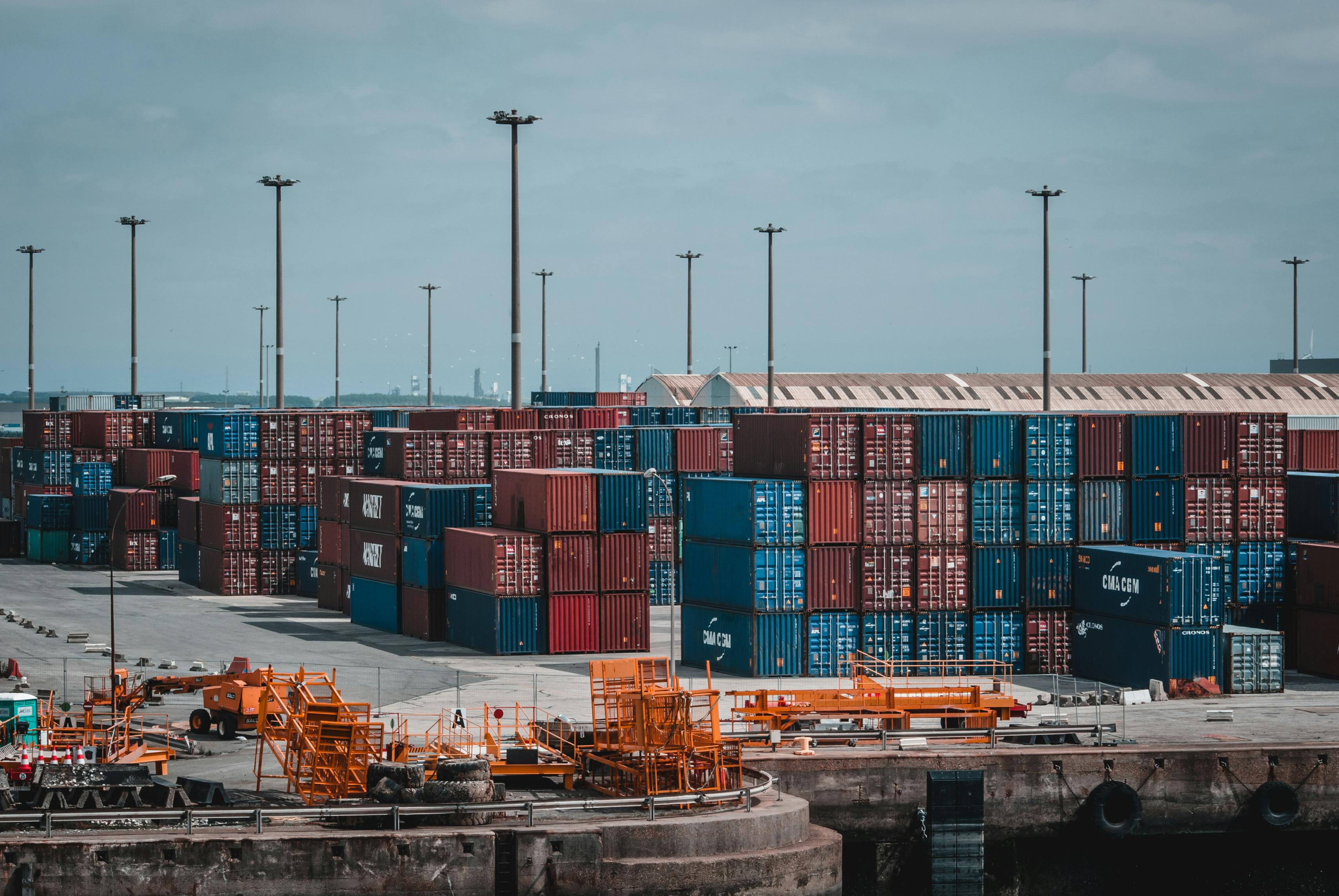
Route Optimization API
Optimize routing, task allocation and dispatch
Distance Matrix API
Calculate accurate ETAs, distances and directions
Directions API
Compute routes between two locations
Navigation API & SDK
Turn by Turn Instructions for Drivers & Technicians
Route Optimization Software
Plan optimized routes with 50+ Constraints
Product Demos
See NextBillion.ai APIs & SDKs In action
AI Route Optimization
Learns from Your Fleet’s Past Performance
Platform Overview
Learn about how Nextbillion.ai's platform is designed
Road Editor App
Private Routing Preferences For Custom Routing
On-Premise Deployments
Take Full Control of Your Maps and Routing
About Us
Our story, vision
and mission
Contact Us
Reach out to us for any product- or media-related queries
Write to us at

Table of Contents
Would you trust the same app that guides your weekend coffee run to safely route a 120,000-pound, over-height load through unfamiliar terrain? For many shippers and drivers, that’s exactly what happens every day. Popular routing apps like Google Maps have become the new normal in everyday navigation, but with overweight and oversized freight, these consumer-friendly applications may become more of a liability than an asset. From low bridges and weight-restricted roads to tight turns and permit-only routes, oversize freight lives in a world of constraints that generic mapping tools simply weren’t built to understand.
The result? Delays, fines, damaged equipment, and risky situations which could have been prevented with routing that is specifically designed to meet the realities of heavy haul. Keep reading to discover why standard routing tools fall short and what oversize freight really needs to stay safe, compliant, and on schedule.
Did you know:
The first step in heavy haul logistics is to figure out whether a shipment is legally oversized (also known as over-dimensional or OD) before the route can be planned or permits requested. It is not merely a semantic classification, as it determines what roads you can use and whether or not you will need escorts, special trailers, or limited traveling hours.
The size and weight regulations in the U.S. are regulated by federal regulations, yet the states have their variations, tolerances, and permit regulations. Even a few inches or a few thousand pounds may make the difference between an ordinary move and a highly controlled heavy haul operation. Such a margin may influence approval of the permits, the feasibility of routes, crossings of bridges, and even the possibility of the load moving.
Although the specific limits depend on the state, a shipment is said to be oversized when it exceeds any of the following generally accepted limits:
When a shipment has surpassed any of these parameters, then it is considered oversized and is subject to special permitting and routing requirements.
Other than the raw dimensions and weight, other characteristics may put a load into the oversize territory:
These factors complicate securement, stability, and clearance analysis, all of which must be reflected in route planning.
In the case of oversized freight, the slightest variations can be huge:
Permit authorities evaluate each load against infrastructure tolerances, and if a route cannot safely accommodate it, permits may be denied outright or rerouted hundreds of miles out of the way.
Once a shipment is classified as oversized, routing must account for:
These are not the variables that consumer navigation tools follow; however, they determine whether a move is safe, legal, and even possible.
Large freight may need special equipment, including:
Proper load securement is equally critical, particularly for large or high freight that influences the stability of the vehicle and traffic. Poor securing is not just a threat to cargo damage, but may cause repositioning of the load, altering the effective dimensions during transit, a potentially serious risk that is frequently ignored.
Cargo Type | Typical Dimensions | Common Uses |
Wind Turbine Blades | Up to 260 feet long | Renewable energy projects |
Construction Cranes | Width: 12-16 feet | Building infrastructure |
Prefab Homes | Height: 14-16 feet | Residential developments |

Although Google Maps has some navigation features, such as driving, public transport, cycling, and walking, it is not designed to serve over-sized freight and commercial trucking. Google Maps does not have any real truck mode. Thus, it does not screen low bridges, weight-limited roads, axles, dangerous material areas, or corridors that require permits.
Its routing algorithm is designed to suit passenger cars with normal car traffic data and generalized road accessibility, which can easily steer oversized or overweight cars into unsafe, illegal, or physically inaccessible routes. This gap can directly result in accidents, infrastructure strikes, cargo damage, disruptions in services, and fines that are expensive to the operators of heavy hauls.
Below are the ways in which Google Maps operates as a critical blind spot for oversized freight:
Google Maps fails to reveal critical truck-oriented points of interest like truck stops, rest areas with truck parking, diesel fueling stations with high flow pumps, DEF distribution, service bays, washouts, or CAT scales. It is also not visible in facilities that have the ability to take long, wide, or multi-axle combinations. In the absence of this data, drivers have to use guesswork or third-party tools to operate Hours of Service compliance, fueling windows, inspections, and mandatory weigh-ins, which decreases productivity and leads to unplanned downtime.
Google Maps does not take into consideration any critical truck limitations (height, weight, width, length, axle configuration, or turning radius) despite offering turn-by-turn directions. It does not check bridge clearances, load limits posted, seasonal road bans, steep grades, sharp curves, or narrow urban streets.
For oversized freight, where inches of clearance and axle load distribution matter, this can result in bridge strikes, roadway damage, stuck vehicles, forced reversals, and violations of state and local truck regulations. It significantly increases both safety risk and liability exposure.
Google Maps does not offer more than 10 stops in a route and does not offer complicated multi-stop optimization logic. The trucking and heavy haul business usually entails complicated arrangements of pick-ups, deliveries, staging yards, inspection locations, escort coordination, stopovers, and rest intervals.
Routes may become inefficient without the possibility to model dozens of stops and optimize them according to the distance, time windows, road restrictions, and hours of the driver. This results in unwarranted mileage, increased fuel consumption, increased wear and tear, and missed delivery windows, which in turn increase operating costs.
Google Maps does not know the nature of loads like cargo sizes, gross weight, axle loads, center of gravity, or the type of trailer. It is not able to confirm that a planned route is within the physical constraints of the truck, trailer, or cargo. This disconnection can cause the vehicle to be sent to a route that is not compatible with its payload, thus underutilization, overload, and reconfiguring on the way. This can compromise safety and efficiency in oversize operations, where the choice of equipment and distribution of loads is closely related to the ability to follow a route.
Although Google Maps does offer general traffic congestion and incident information, it does not offer real-time alerts that would be specific to truck and oversize requirements. It is not a consistent measure of reduction in the width of the lanes, temporary height restrictions, alteration of weight limits, work zones impacting the large vehicles, and corridors with escorts only.
It may also miss notifications about bridge inspections, detours unsuitable for trucks, or time-of-day restrictions for heavy vehicles. For oversize freight, where detours are often not viable, missing this intelligence can force dangerous last-minute decisions.
For cross-border freight, Google Maps does not incorporate country-specific truck regulations, dimensional standards, cabotage rules, border wait times, customs procedures, or required documentation. It also fails to consider the varying road categories, toll systems, or heavy vehicle restricted roads in other nations. Such regulatory and procedural context deficiency can subject international shippers to compliance failure, shipment delay, border rejection, and financial punishment.
Google Maps is a consumer-based navigation product that does not have enterprise-level fleet management capability. It does not work with vehicle-specific profiles, route policy, dispatching workflow, geofencing, real-time vehicle tracking, and integration with telematics, TMS, or ELD systems.
In operations involving tight coordination between dispatchers, drivers, escorts, and compliance teams that cannot be customized or integrated with other systems, this lack of customization and system integration restricts operational control and efficiency of the fleet.
Google Maps lacks formal reporting and analytics of route performance, delivery times, dwell periods, fuel efficiency, compliance events, and driver behavior. In the absence of these insights, fleets will be unable to conduct a systematic review of performance, detect bottlenecks, optimize future routes, or show customers compliance and quality of service. In heavy haul operations, where every move is high cost and high risk, the absence of data-driven feedback is a significant operational disadvantage.
In addition to Google Maps, numerous fleets and drivers resort to numerous navigation and route planning solutions. These are supposed to be more supportive of commercial vehicles. Some of these platforms add basic truck-aware capabilities. However, the vast majority are still based on the same basic freight and general logistics, rather than the extreme demands of oversized and overweight loads. The heavy haul moves are at the boundary of the infrastructure constraints, where generic truck routing logic fails to work.
Below are key categories of commonly used tools and the gaps they present for oversize freight operations.
Certain consumer applications and GPS devices promote truck or RV modes in which users can enter simple dimensions of the vehicle. Such tools can strive to circumvent low bridges or limited roads, but are generally based on incomplete or stale data.
Key limitations:
In the case of oversize freight, one misplaced clearance value may lead to a bridge strike, and partial truck awareness is insufficient.
A number of commercial routing systems have been designed specifically to support trucking and offer truck-restricted routes, height avoidance, and HOS-conscious routing. While these are a step up from consumer apps, most are optimized for dry van and reefer operations within legal limits, not for true heavy haul.
Typical gaps include:
These tools may work for “slightly over” loads, but often break down when faced with multi-hundred-thousand-pound or extreme height moves.
Telematics vendors tend to offer navigation packages with vehicle monitoring, ELD, and driver management. Their routing engines are efficiency-oriented, ETA-oriented, and adhere to the general truck restrictions.
Where they fall short:
For heavy haul, knowing where the truck is does not solve whether it can physically or legally go there.
TMS platforms are used by many shippers and carriers in their planning and execution. Some of them have route optimization modules, but they are normally cost and time-based.
Common oversize limitations:
As a result, routes may look optimal on paper but prove impossible once the load hits the road.
Without proper tools, several heavy haul planners continue to use a mix of satellite images, DOT maps, bridge inventories, and experience.
Challenges of this approach:
The local knowledge is priceless, but modern oversize freight needs to have systematic, repeatable, and data-supported routing procedures.
Perhaps the biggest gap across most tools is the absence of permit-aware routing. Oversized freight not only requires a physically feasible route, but it also requires a route that is consistent with what state and local authorities will permit in practice.
Most tools do not:
This compels the planners to consider routing and permitting as two distinct processes, which adds delays and rework.
Extreme oversize and overweight moves often require engineering analysis of bridges, culverts, pavement stress, grades, and load paths.
Typical routing tools lack:
Without this, routes may be theoretically allowed but practically unsafe.
In December 2025, an oversized truck hauling an over-height load struck and damaged six county overpass bridges above Interstate 44 and the Will Rogers Turnpike in northeastern Oklahoma. The truck’s cargo was measured at more than 15 feet tall, exceeding Oklahoma’s legal limit of 14 feet for vehicles on the state highway system, and was not properly permitted for travel on the route. Several bridges were closed for inspection and repair while crews determined the extent of the structural damage. Oklahoma Turnpike Authority officials described the incident as a serious risk to public safety and infrastructure.
Lessons learned- This incident shows that oversize freight must be properly routed with accurate clearance data and valid permits to avoid damaging infrastructure. It also highlights the need for real-time route verification and strict enforcement of state height limits.
In October 2025, an oversized load struck the Bullfrog Road overpass on Interstate 90 near Cle Elum, Washington. The load caused significant damage to the overpass structure, prompting closure of the westbound lanes of the interstate for safety while state transportation officials and emergency crews assessed the damage. The Washington State Department of Transportation reported that the overpass could not be repaired and needed to be demolished to allow reconstruction, and emergency contracting was authorized to expedite the work.
Lessons learned: This case highlights the importance of strict adherence to permitted routing and the consequences when oversize loads encounter structures with inadequate clearance. It also shows the high cost and disruption that can result when an interstate overpass must be closed and rebuilt after a preventable collision.
While Google Maps is the world’s most popular navigation tool, it is designed for a six-foot-wide car, not a sixteen-foot-wide superload. In the case of oversized freight, one routing error does not imply only a delay. It may lead to a bridge strike, fines of six figures, loss of cargo, or even devastating infrastructure damage.
Professional logistics teams have shifted to a dedicated location intelligence and heavy haul routing stack to overcome these risks, leaving behind the use of consumer GPS tools. Here is how they ensure safety, compliance, and efficiency.
In contrast to Google Maps, which presupposes the use of a universal vehicle size, professional routing systems enable planners to specify the physical and operational specifics of each movement.
Dimensions and Axles: Type in exact height, width, length, and the number of axles. Even a few inches can change which bridges, tunnels, and corridors are feasible.
Weight Dynamics: Indicate the gross vehicle weight and axle loads. Axle modeling is important to heavy haul because many bridges have axle group limits, but not total GVW.
Hitch and Trailer Type: Set up trailer type, swing-out behavior, and turning radius in such a way that the system is able to determine the possibility of the vehicle to physically manoeuvre around tight intersections, roundabouts, and ramps.
This transforms routing from generic navigation into vehicle-aware feasibility analysis.
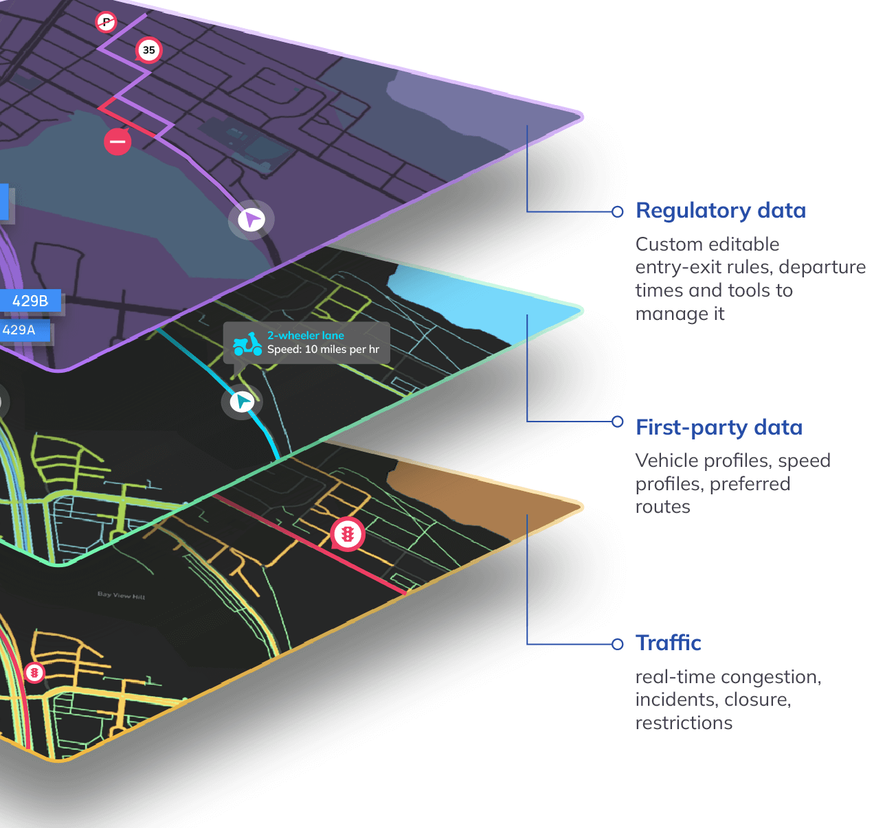
The fundamental weakness of regular navigation tools is the absence of road features. Special-purpose heavy haul software employs enriched map layers that contain:
Vertical Clearances: Certified measurements of bridges, overpasses, tunnels, and sign gantries, usually kept as DOT inventories and field surveys.
Bridge Strength and Ratings: Information on load ratings and structural capacity, which assists in establishing whether a bridge is able to support excessively heavy axle weights or superloads.
Truck and Heavy Haul Truck Routes: Filtering of corridors that have been approved by Departments of Transportation to carry oversized and overweight moves, including bypasses and restricted areas.
These layers not only make routes connected, but also structurally and legally traversable.
The oversized freight is subject to a maze of rules that vary by state, county, and even city.
Dynamic Time Constraints: Professional tools include curfews like no travel during rush hours, weekends, holidays, or nighttime, and they are directly reflected in ETA calculations.
State-Line Compliance: With routes traversing jurisdictions, systems are used to automatically enforce new dimensional boundaries, escort regulations, speed limits, and travel timeframes.
Permit-Aware Routing: The routes are developed to match the routes that will be actually approved by the authorities, minimizing the rework and denial of permits.
This makes routing and permitting a single workflow and not independent processes.
After a compliant route has been developed, drivers use truck-specific navigation applications instead of consumer applications.
Visual and Audio Warnings: Specialized truck GPS applications give warnings of imminent low clearances, sharp turns, steep grades, and limited roads.
Truck-Focused POIs: They emphasize truck stops, high-flow diesel fuel, rest areas, scales, and oversized parking.
Community Intelligence: The other drivers report sudden closures, construction zones, and enforcement activity, which is crowdsourced.
This provides the drivers with real-time situational awareness in accordance with the planned heavy haul route.
For extreme loads, even the best data is not enough. Technology is paired with human validation.
Digital Simulation: The 3D and swept-path modeling are used to simulate the movement of the vehicle through narrow intersections, curves, and ramps to ensure that the vehicle can make the turn before it is dispatched.
Physical Route Surveys: Escort or pilot cars reconnoiter parts of the route beforehand to detect any temporary hazards like construction, parked vehicles, utility lines that are low, or obstructions at the edge of the road.
Together, these steps turn routing into an engineered operation, not just a planned trip.
Dedicated Truck GPS Apps
GPS apps in trucks are designed to run on a commercial truck. They also consider truck size, height, weight, type of cargo, bridge clearance, restricted roads, and legal truck routes, unlike the normal navigation tools.
Popular options include:
Trucker Path: Offers live hazard alerts by motorists, visibility of weigh stations open, oversized parking spots, and construction status. It assists in the mitigation of incidences by informing drivers about the state curfews and possible escorting needs.
CoPilot Truck: Provides offline maps and turn-by-turn voice navigation designed to support semis and heavy vehicles. Its height-conscious routing prevents steep grades and unproductive routes that cause a higher consumption of fuel and braking danger.
SmartTruckRoute: Routes are created depending on the size of the trucks, weight capacity, hazmat types, and existing road restrictions that assist the drivers to avoid low bridges and restricted routes.
These tools enhance in-cab execution, although they are best used in conjunction with professional pre-trip planning.
In the case of fleets and logistics teams, the best solution is enterprise-level route planning software that is specifically designed to handle complex freight.
Such platforms reduce oversize freight as a reaction to a problem in precision logistics, which prevents disasters like bridge strikes, stalled loads, and permit violations.
NextBillion.ai: Offers Directions and Optimization APIs that combine live traffic, weather, and DOT information to produce routing that is compliant. Its vehicle profiles permit oversize load customization, whereas fuel-saving sequence assists in controlling operating expenses in large and multi-stop networks.
Locus.sh: Optimizes multifaceted logistics based on AI-powered constraint engines that consider axle weights, escort, time windows, and Hours of Service. It provides predictive ETAs and dispatcher dashboards that enhance visibility and on-time delivery in heavy haul operations.
These platforms allow fleets to simulate thousands of stops, impose regulatory restrictions, and build routing into TMS and dispatch systems.

NextBillion.ai solves the oversized freight issue by solving what cannot be solved by the consumer mapping custom APIs in the first place: the mathematics of constraints and the physics of infrastructure. Rather than using a generic vehicle on a generic road network, NextBillion.ai enables the logistics teams to directly encode the actual physical, legal, and operational facts of any move into the routing engine.
Routing in heavy haul is not concerned with the fastest route. It is regarding the search for a way that is physically accessible, legally allowed, operationally feasible, and economically reasonable. NextBillion.ai allows this by allowing teams to hard-code their oversize constraints into the model such that any route that is produced is, by design, feasible, rather than being fixed after failure.
The fundamental aspect of oversize logistics is permit-aware decision-making. The AI-based optimization platform of NextBillion.ai accepts data on inventory systems, delivery orders, vehicle profiles, driver availability, map layers, and regulatory rules, and generates routes that adhere to permit logic initially. This conceptually replaces routing by navigation with routing by regulatory computation.
This is how it manages to overcome the problem of oversized freight:
This creates a living model of compliance where routes evolve with regulations, not after violations.
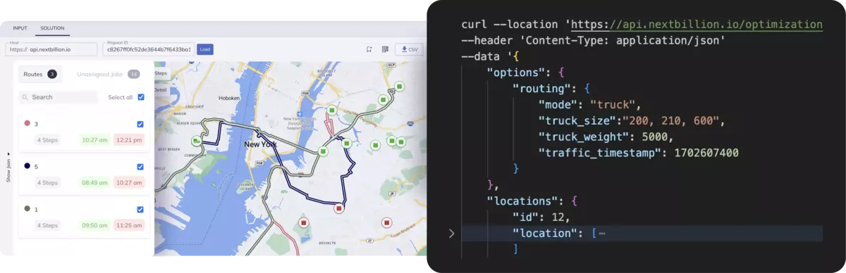
NextBillion.ai offers a full API ecosystem, which can be embedded into TMS, dispatch, and fleet systems and permit-aware routing, as opposed to being run as a separate map. The APIs have important conceptual roles, which are:
Together, these APIs transform routing into a constraint-solving platform rather than a simple pathfinding service.
Permit-based routing means the route itself becomes part of the permit. It must encode:
NextBillion.ai maps directly to this model by allowing:
This aligns digital routing logic with how permits are actually issued and enforced in the real world.
Oversize routing is not only about roads. It is also about whether the cargo can be loaded and transported as planned.
NextBillion.ai supports capacity planning that goes beyond weight to include 3D volume and orientation constraints. This model determines whether cargo must remain upright, can be rotated, or must sit on a fixed base, and whether the vehicle’s compartment can physically accommodate the configuration.
This is especially critical in sectors such as furniture, appliances, machinery, and equipment logistics, where:
For example, in a furniture delivery scenario:
By applying 3D spatial validation with orientation rules such as strict, parallel, or fixed_bottom, the routing system ensures that the plan is not only drivable, but loadable. This reduces failed stops, improves vehicle utilization, and prevents costly last-minute reassignments.
Conceptually, this closes the loop between what can fit in the truck and where that truck can legally go.
What NextBillion.ai represents is a shift from navigation to computational logistics engineering:
For oversized freight, this approach turns high-risk moves into repeatable, auditable, and scalable operations, where every route is engineered to be safe, legal, and executable before the truck ever starts its engine.
Oversize freight demands engineered routing, not consumer navigation. Google Maps and popular tools ignore dimensions, permits, axle loads, and infrastructure limits, turning convenience into risk. The solution is vehicle-aware, permit-driven, data-rich platforms that integrate planning, compliance, and execution, ensuring every heavy haul move is safe, legal, efficient, and repeatable operations.
Explore how NextBillion.ai can quietly fit into your operations, bringing permit-aware routing, infrastructure intelligence, and vehicle-specific optimization to your heavy haul planning, so every oversized move is engineered for safety, compliance, and efficiency from the very first mile.
Google Maps is designed for passenger vehicles and does not account for load height, weight, axle limits, or permit restrictions required for oversize freight.
No. Google Maps does not reliably screen low clearances, bridge load limits, or roads restricted for overweight or over-dimensional vehicles.
Using consumer maps can lead to bridge strikes, permit violations, fines, equipment damage, and dangerous roadside situations.
Truck-specific routing considers vehicle dimensions, axle configurations, approved corridors, permits, and time-of-day restrictions to ensure compliance.
Dedicated heavy haul and permit-aware routing platforms are required to safely plan, approve, and execute oversize freight movements.
Bhavisha Bhatia is a Computer Science graduate with a passion for writing technical blogs that make complex technical concepts engaging and easy to understand. She is intrigued by the technological developments shaping the course of the world and the beautiful nature around us.

