


Table of Contents
Most routing APIs are built for standard navigation—finding the fastest or shortest path between points. While this works for general travel or delivery use cases, it doesn’t hold up in industries where permits, restrictions, and compliance rules shape how vehicles move. Here’s why traditional routing APIs struggle to meet regulatory and operational demands.
Traditional routing systems depend on fixed datasets that are rarely updated or lack regional accuracy. These datasets might include basic road types, speed limits, or traffic patterns, but they often ignore real-time or dynamic conditions.
For example, a city may impose a temporary truck restriction due to construction or seasonal closures on mountain routes. A standard API wouldn’t reflect these updates immediately, leading to invalid or inefficient routes. In compliance-heavy operations, such inaccuracies can result in fines, delays, or unsafe routing decisions.
Another major limitation lies in how traditional APIs treat vehicles. Most only recognize basic parameters such as car, bike, or truck—without deeper granularity. They don’t account for vehicle weight, axle configuration, cargo type, or height restrictions, all of which determine whether a route is legally and physically feasible.
For instance, a 12-ton truck carrying hazardous material might be routed through a tunnel that prohibits such cargo. Without permit-based routing or advanced vehicle attributes, APIs can’t prevent these violations or optimize for compliance.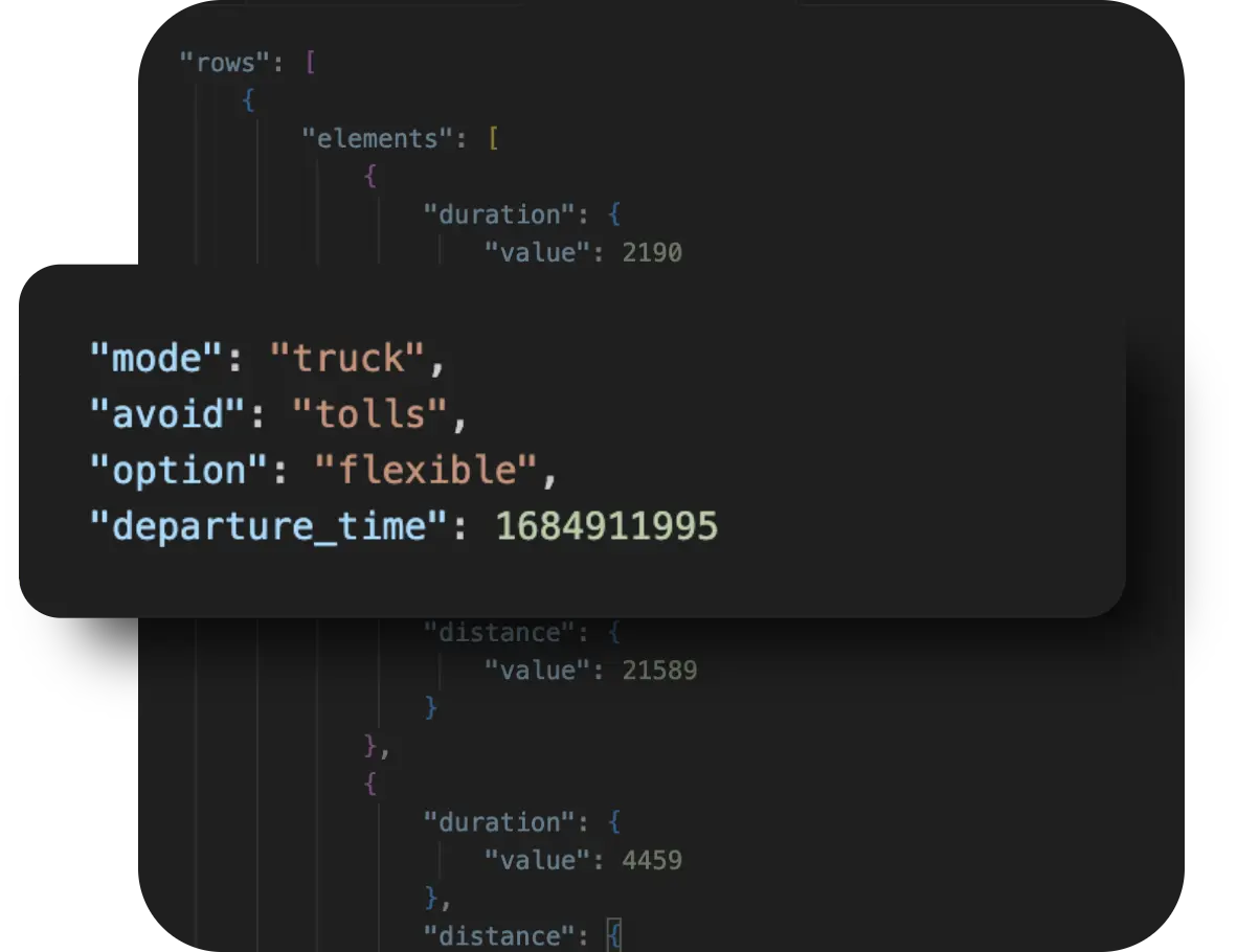
Routing rules vary widely across regions, and most APIs aren’t built to accommodate this diversity. Municipalities often have no-truck zones, low-emission areas, or restricted bridges that apply only during certain hours. Traditional APIs use global datasets that overlook these localized restrictions, making them unsuitable for fleets operating across multiple jurisdictions.
This absence of custom map layer integration means dispatchers can’t visualize or avoid restricted areas, forcing manual workarounds that reduce efficiency and increase operational risk.
In short, the main routing API limitations stem from a one-size-fits-all design. To achieve permit-aware and regulation-compliant routing, systems must evolve to include custom map layers, restricted segment data, and dynamic rule integration. These capabilities ensure that every route respects both geography and regulation—essential for fleets operating in complex, compliance-driven environments.
A permit-aware routing engine combines multiple data sources and logic layers to create routes that are both efficient and regulation-compliant. Unlike standard routing systems that rely on general road and traffic data, this setup integrates custom datasets and permit logic to ensure vehicles only travel on authorized paths. Below are the key components that make this possible.
The routing API forms the foundation of the system. It computes optimal routes by analyzing road networks, real-time traffic, and various restriction parameters. Advanced APIs—such as the NextBillion.ai Route Optimization API—allow you to specify conditions like avoiding restricted roads, adhering to vehicle-specific rules, or applying dynamic “avoid” parameters.
Example use case: Optimizing routes for delivery trucks that must avoid low-clearance bridges and restricted tunnels.
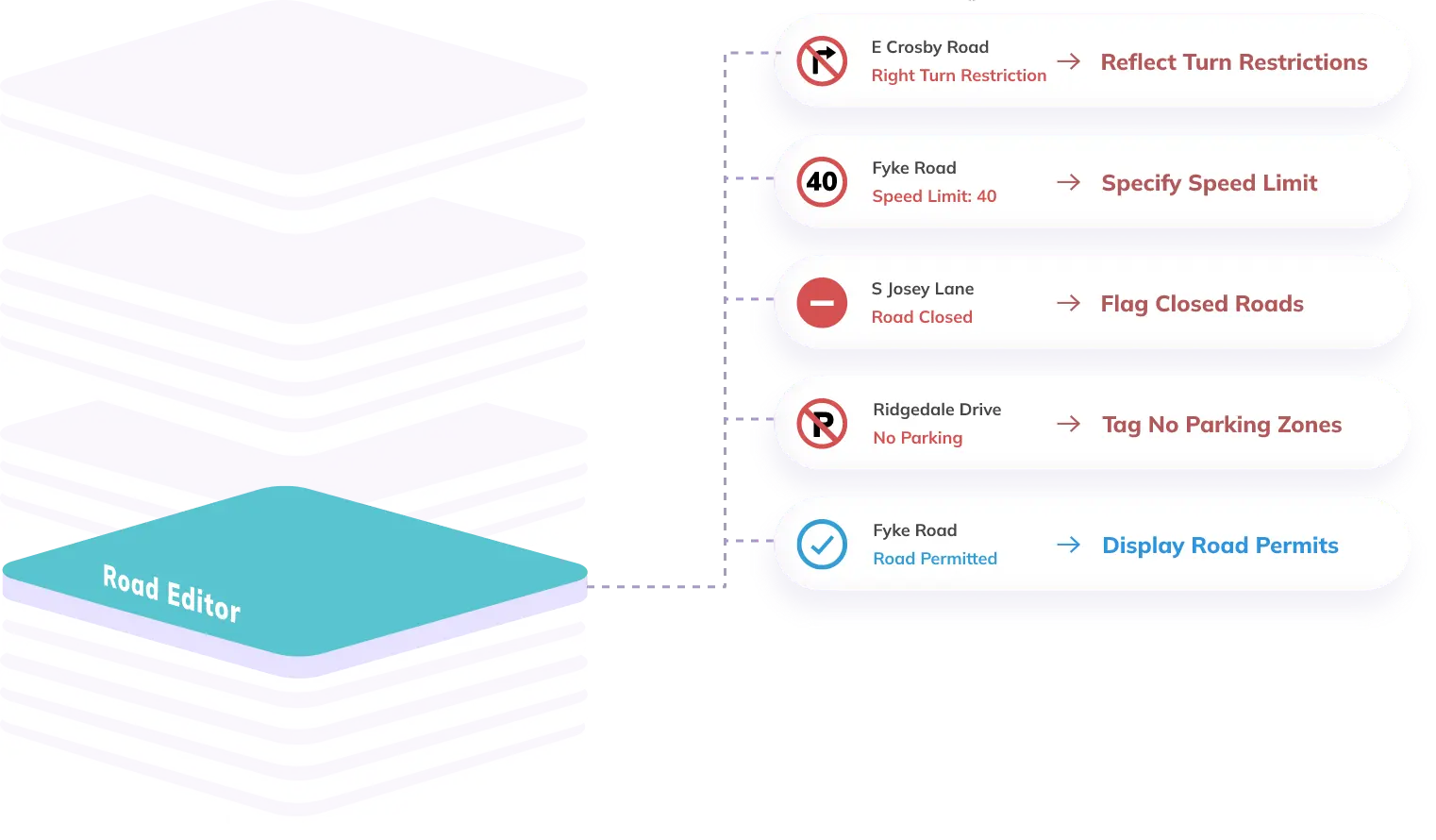
Custom map layers add localized intelligence to the routing engine. These layers represent data overlays—such as weight limits, hazardous material restrictions, or time-based access controls—that standard maps don’t include. They help visualize and enforce region-specific regulations that affect vehicle movement.
Example use case: Defining city-specific HAZMAT zones where certain trucks are prohibited during business hours.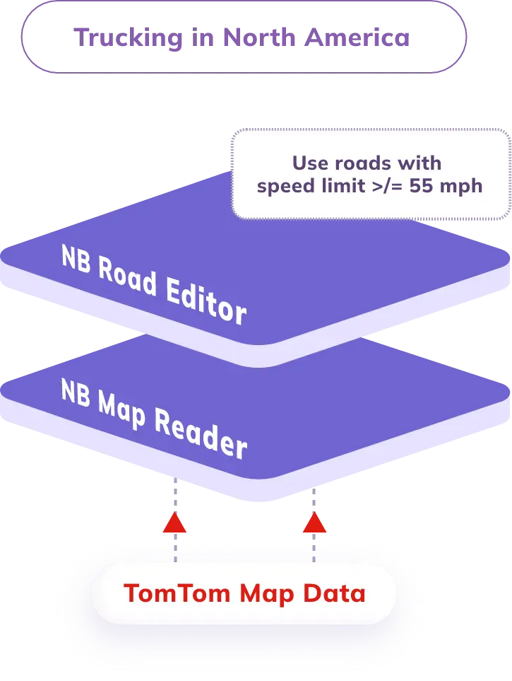
This component defines specific road segments that require permits or are completely restricted to certain vehicle types. By tagging these segments, you can instruct the routing API to avoid or conditionally use them based on vehicle credentials or time windows.
Example use case: Routing around seasonal forest roads that close during winter or bridges that have strict weight limits.
A permit database connects the routing engine to external permit management systems or local government datasets. This integration ensures routes reflect the latest regulatory permissions and automatically validate whether a vehicle holds the required permits.
Example use case: Checking DOT-issued truck permits or city clearance records before confirming a route.
When combined, these four components—routing API, custom map layers, restricted segment data, and permit database integration—form the core architecture of a permit-aware routing engine. Together, they enable precise, regulation-compliant routing across dynamic and highly controlled transport environments.
Building a permit-aware routing system involves combining routing intelligence with vehicle-specific and regulatory data. The goal is to ensure that every route respects permit conditions, vehicle limitations, and local access rules. Here’s a technical breakdown of how you can build such a system using modern Routing APIs provided by NextBillion.ai.
Start by selecting a routing API that allows you to import custom data layers and define restricted segments. The API should let you upload geo-referenced datasets for areas such as restricted zones, low-emission corridors, or permit-only bridges.
Example: NextBillion.ai’s Routing API supports real-time custom data ingestion using endpoints for custom layers and routing profiles.
For more details, refer to Zone-Based Allocations using Route Optimization API.
Gather restricted road data from open sources like OpenStreetMap, local DOT APIs, or permit management systems. Standardize this data in a format the routing API can process—typically GeoJSON or shapefiles.
Each restricted segment should include attributes like:
Road Segment API gives you the details of all the road segments within a specific geographic area.
After preparing your restricted segment data, the next step is to create and upload custom map layers that reflect real-world regulatory and safety constraints. These layers act as data overlays on top of your base map, guiding the routing engine to avoid restricted zones and choose compliant paths.
Using a Routing API like NextBillion.ai’s Directions API and Navigation API, you can model complex restrictions—such as hazardous material routes, low-emission zones, or weight-limited bridges—and dynamically apply them to your routing logic.
For instance, when dealing with hazardous cargo, it’s not enough to simply avoid residential areas or tunnels. You must ensure that the route complies with HAZMAT transport regulations. NextBillion.ai’s APIs simplify this by using the hazmat_type parameter within the routing request. This parameter lets the engine recognize the type of hazardous material being transported and automatically restricts routing to legal and safe corridors.
Here’s an example setup:
{
“origin”: [77.5946, 12.9716],
“destination”: [77.6411, 13.0033],
“mode”: “truck”,
“option”: “flexible”,
“hazmat_type”: “flammable”
}
This request instructs the routing engine to:
In addition to the hazmat_type logic, you can upload custom map layers that define:
Each custom layer can be tagged with metadata such as { “avoid”: “hazmat_zone” } or { “permit_required”: “city_clearance” }, enabling the routing API to make context-aware decisions.
By combining hazmat-specific routing parameters with custom map layers, your routing system can deliver fully compliant, context-sensitive paths for any vehicle type—whether transporting standard goods or hazardous materials.
Define vehicle properties in the routing request using the vehicles array. Each vehicle object should represent its operational and physical constraints.
Here’s a sample configuration:
“vehicles”: [
{
“id”: “Truck_01”,
“description”: “HAZMAT transport vehicle”,
“start_index”: 0,
“end_index”: 12,
“capacity”: [10000],
“time_window”: [1730880000, 1730916000],
“skills”: [1, 2],
“max_tasks”: 5,
“costs”: {
“per_km”: 1200
},
“speed_factor”: 0.85,
“allowed_zones”: [101, 102],
“restricted_zones”: [201, 202],
“volume”: {
“width”: 2.5,
“depth”: 6.0,
“height”: 2.5
}
}
]
This configuration tells the routing engine to only assign jobs that comply with the truck’s permits, dimensions, and allowed zones. It also limits the route based on distance, working time, and vehicle type.
Once the vehicle attributes and custom map layers are ready, configure your routing parameters in the API call.
Example parameters include:
The routing engine now calculates paths based on both map-based restrictions and vehicle capabilities.
Run test routes through your API and compare the generated paths with real-world constraints. Validate against known restrictions to ensure compliance. Then, refine the logic using real-time feedback loops—for instance, updating restriction layers or modifying vehicle profiles based on permit changes.
Use APIs that support dynamic “avoid” lists, allowing you to modify restricted areas without reloading datasets. This flexibility helps the routing engine adapt to temporary regulations, such as construction detours or special event closures.
By following these steps, you can build a scalable, permit-aware routing system that intelligently adapts to vehicle profiles, dynamic restrictions, and compliance data. This architecture ensures your routes are optimized for both efficiency and legality, making it ideal for logistics, construction, and regulated freight operations.

