Google maps alternative banner

Best 7 Google Maps Alternatives & Competitors in 2024

Google Maps is used worldwide for basic route planning and complex route optimization scenarios, but is it suitable for organizations dealing with large and complex fleet management scenarios? If you are looking for a comprehensive list of  Google Maps alternatives and competitors, you have come to the right place. 

Google Maps might not be suitable for:

  • Complex route planning scenarios.

  • Large fleet management cases.

  • Organizations concerned with data security issues.


In this article, we have tested 7 route planning solutions like
NextBillion.ai as Google Maps alternatives. Let’s explore each of these solutions in detail. 

Why You Can’t Trust Google Maps?

Google Maps is a widely used tool for navigation, but it’s not without flaws. Here are three reasons why you may want to think twice before trusting it completely.

1. Location Tracking


One of the most concerning issues with Google Maps is its ability to track your location, even when you think you’ve turned off location services. Unless you also disable Web & App Activity in your Google account settings, Google continues to collect data about where you go. Every time you open Google Maps or other Google apps, timestamps are sent back to Google, creating a detailed timeline of your movements.

This data isn’t just stored; it’s used to serve you targeted ads based on your location history. For those concerned about privacy, this raises serious issues about the extent of control Google has over your personal information. Even if you aren’t using Google Maps actively, your location history could still be logged and used in ways you may not be aware of.

2. Road Suitability


Google Maps excels at providing the fastest route to a destination, but it doesn’t always take into account the type of vehicle you’re driving. The app doesn’t differentiate between a heavy-duty truck, a motorbike, or a standard car. As a result, drivers may be directed down roads that aren’t suitable for their vehicle.

For instance, some roads may be too narrow for larger vehicles, or too steep for motorcycles, which can create dangerous situations. Furthermore, certain areas may have restrictions that aren’t adequately highlighted in Google Maps, such as weight limits for bridges or off-road paths unsuitable for regular cars. This lack of consideration can lead to hazards or delays, especially if you’re unfamiliar with the area.

3. Data Uncertainty


While Google Maps relies on a vast amount of data to create accurate representations of roads, landmarks, and routes, that data comes with a degree of uncertainty. This uncertainty can vary significantly depending on the area. In cities, where data is frequently updated and verified, you’re likely to get a more accurate experience. However, in rural or remote regions, the data may be outdated, incomplete, or even incorrect.

Maps that rely on crowdsourced information are also prone to inaccuracies. A road might be listed as passable when it’s closed for construction, or a business might still be marked open long after it’s been shuttered. These gaps in data can lead to confusion, misdirected routes, or even dangerous scenarios where drivers are guided into inaccessible areas.

Reasons to Use a Google Maps Alternative?

google maps alternative

Google Maps is undeniably one of the most widely used mapping platforms globally, offering many features and functionalities. However, despite its popularity, users and businesses encounter several shortcomings, prompting them to seek alternatives. 

Let’s dive into some key reasons why exploring alternative mapping solutions might be beneficial.

1. Mapping Issues


While Google Maps boasts extensive coverage, there are instances where users encounter mapping inaccuracies. These issues could range from outdated or missing information about businesses and points of interest to errors in navigation routes. For businesses relying heavily on accurate mapping data, such discrepancies can lead to customer dissatisfaction and operational inefficiencies.

2. Pricing Concerns


Google Maps offers a free tier for basic usage, but businesses with high-volume usage or those requiring advanced features may find the pricing structure less favorable. The costs associated with premium features and increased usage can quickly escalate, potentially straining budgets, particularly for smaller businesses and startups.

3. Accuracy Challenges


Accuracy is paramount when it comes to mapping platforms, especially for industries such as logistics, transportation, and emergency services. Despite Google’s efforts to maintain accurate mapping data, discrepancies in location information, business listings, and routing algorithms can undermine the reliability of the service.


4. API Limitations


Google Maps API is widely used to embed maps and location-based services into websites and applications. However, developers often encounter limitations and restrictions that hinder customization and integration with existing systems. Alternative mapping solutions may offer more flexible APIs with fewer constraints, allowing for greater customization and seamless integration.

5. Data Inaccuracy


Inaccurate or outdated data can pose significant challenges for businesses relying on mapping platforms for decision-making and operations. Whether it’s incorrect business hours, outdated contact information, or missing locations, such inaccuracies can lead to customer frustration and lost opportunities. Exploring alternatives with reliable data sources and robust verification mechanisms can mitigate these risks.

6. Privacy


One of the major drawbacks of using Google Maps is the way it tracks and stores your location data. Even with location services turned off, Google can still collect data through other services like Web & App Activity. This information is then used to build a detailed profile of your movements and habits, which is sold to advertisers for targeted marketing.

7. Using Maps Offline


Another limitation of Google Maps is its reliance on a constant internet connection for full functionality. While Google does offer the ability to download maps for offline use, the experience is often limited. Features like real-time traffic updates, business hours, and reviews are unavailable offline, reducing the app’s effectiveness in areas with poor or no signal.

8. Outdoor Activities


If you enjoy outdoor activities like hiking, cycling, or off-road driving, Google Maps often falls short. The app is built mainly for city navigation, and while it may display major trails, it needs detailed topographic maps or specialized routes for outdoor enthusiasts. This makes it less ideal for planning or navigating through wilderness areas.

While Google Maps remains a dominant player in the mapping industry, it’s essential for businesses to evaluate their mapping needs critically and consider alternatives that address their specific requirements. Whether it’s concerns about mapping accuracy, pricing, API limitations, or data integrity, exploring alternative mapping solutions can provide businesses with greater flexibility, reliability, and control over their location-based services. 

By diversifying their mapping tools and adopting solutions that align with their unique needs, businesses can enhance customer experiences, optimize operations, and drive growth in an increasingly location-centric digital landscape.

The Best Google Maps Alternatives

These are the best Google Maps alternatives as per their key feature and use cases.

  1. NextBillion.ai – Best route optimization capabilities.


  2. MapQuest – Free route planner up to 26 stops.


  3. Waze – Real-time traffic alerts.


  4. Here WeGo – Free navigation app for local guides and tourists.


  5. Sygic – Seamless integration with car connectivity system.


  6. Openstreetmap- Ideal for road trip planning or camping up to 25 stops.


  7. Maps.me – Offline navigation capabilities


Alternative

Features

Pros

Cons

Rating

NextBillion.ai

Advanced Truck Routing Support.

Advanced Route Optimization

Re-optimization feature

Telematics Integration.

Flexible Pricing

Geocoding Limitation.

4.7/5

MapQuest

Free route planning upto 26 stops.

Automatics IRS calculation.

Ease of use.

Visual Design

Ads can distracting

4.0/5

Waze

Real-Time Traffic Updates.

Community-Driven.

Carpooling.


Free to use.

Limited route planning capabilities

3.8/5

Here WeGo

Offline Maps.

Public Transit Directions.

Points of Interest.


Free to use

Interface Complexity

4.0/5

Sygic

Offline Maps.

Dashcam.

Family Locator.


Extensive Offline Maps.

Advanced Navigation Features.


Subscription based Pricing.

4.6/5

Maps.me

Turn-by-Turn Navigation.

Points of Interest.

OpenStreetMap Integration.

User-Friendly Interface

Detailed Mapping Data


Limited Navigation Features

Data Consumption

4.1/5

OpenStreetMap 

Customizable Maps.

Global Coverage.

Open Data.

Free and Open

Community-Driven


Steeper Learning Curve

Limited Support

3.8/5

1. NextBillion.ai’s Route Optimization API

NextBillion.ai’s Route Optimization API offers advanced route planning capabilities for complex scenarios. This API is capable of solving multi (single) vehicle routing problems. 

The API comprises two key components: the input data and the optimization engine. The input data contains information about elements such as jobs (stops or places to visit), vehicles (delivery trucks, vans, etc.), and shipments (pickup and delivery tasks). The optimization engine uses this data to craft the most efficient routes for your vehicles.

What sets the API apart is its ability to manage complex constraints and variables. Whether it’s considerations like capacity limitations, time windows for deliveries, or vehicle availability, the API accommodates these logistical needs. This adaptability enables businesses to tailor the route planning process precisely to their unique operational requirements, ensuring maximum efficiency and cost-effectiveness.

With this API, businesses can streamline their logistics operations, minimize resource wastage, and enhance overall productivity. 

Key Features of Route Optimization API

Let’s explore some of the key features that set the Route Optimization API apart.

1. Advanced Truck Routing Support

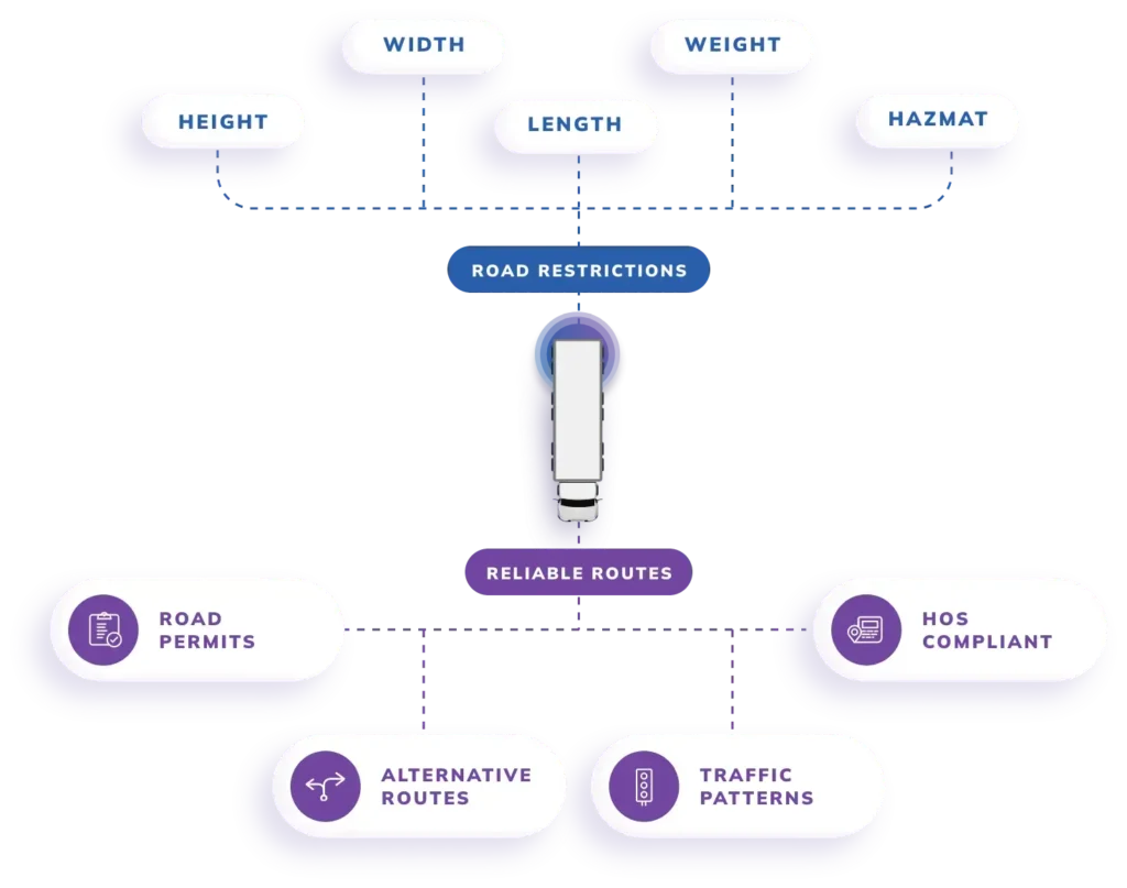
The API offers a range of advanced features tailored for efficient trucking operations. It ensures compliance with truck-specific parameters like size, weight, and hazardous material restrictions, optimizing routes to avoid unsuitable roads. 

With over 50 constraints available, the API efficiently manages fleets of multiple trucks, delivering optimized routes and schedules. It prioritizes safety by avoiding sharp turns and U-turns and provides routes suitable for hazardous cargo transportation. 

NextBillion.ai Trucking features

The API enables efficient planning of routes with multiple stops while ensuring trucks arrive precisely at curbsides. Post-trip analysis is simplified with route tracing functionality, allowing businesses to monitor route adherence and optimize future planning. 

Service boundaries can be defined within specified constraints, and toll roads can be avoided to optimize cost-effectiveness. Additionally, the API considers weight limits when planning routes, ensuring compliance with regulatory requirements and smooth transportation operations.

2. Telematics Integration

The API integrates smoothly with telematics systems, making it easier for businesses to improve their logistics operations. With NextBillion.ai, businesses can link up their current Enterprise Cloud, Telematics, ERPs, and CRM platforms to access advanced features for optimizing routes and managing services better.

Route optimization set up

By connecting NextBillion.ai with telematics systems, businesses can use real-time data about where vehicles are, their routes, and how they’re performing. This connection allows for dynamic route planning that takes into account live traffic updates, the condition of vehicles, and how drivers are doing. This means you can plan routes more efficiently and be more responsive to changes as they happen.

3. Re-optimization Feature for Unassigned Tasks

NextBillion.ai‘s Route Optimization API offers a handy re-optimization feature, allowing users to tackle previously unassigned tasks by tweaking certain variables. 

These variables could be things like adjusting the number of vehicles needed, changing vehicle schedules or capacities, or tweaking task time windows. Essentially, it’s about finding strategies to increase the likelihood of getting more tasks assigned.

Here’s how it works: Let’s say you’ve already run an optimization but ended up with some tasks left unassigned. With re-optimization, you can tweak your request using the strategies mentioned above and explicitly specify the tasks that were left out. 

re-opitimization feature

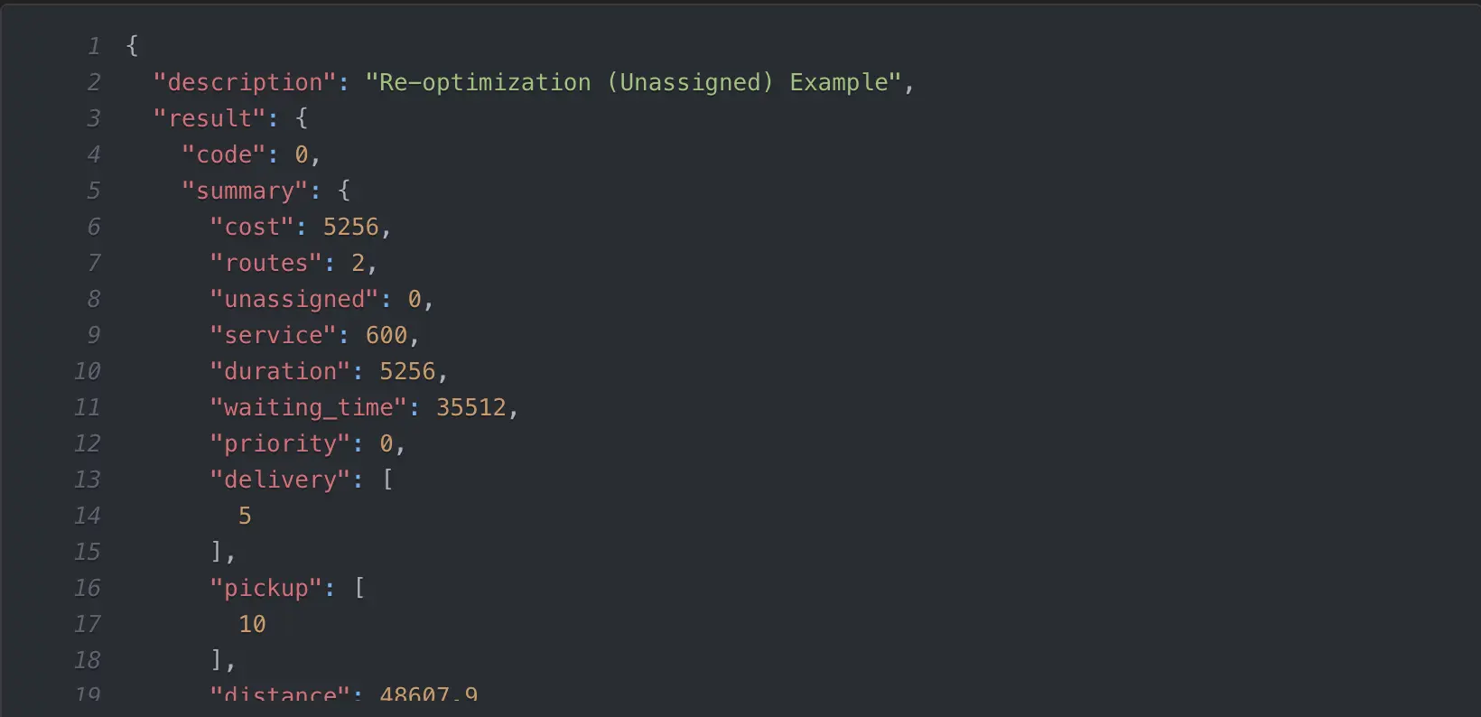
When you send this re-optimization request, the solver will try to fit these new tasks into the original plan with minimal changes. This allows businesses to quickly adjust their route plans, even at the last minute, without having to overhaul everything from scratch. It’s a convenient way to adapt to changing circumstances without major disruptions to your existing plans.

NextBillion.ai’s Pricing

NextBillion.ai Pricing

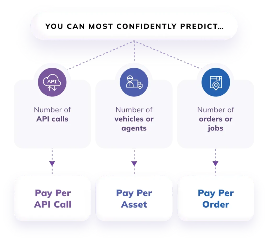
NextBillion.ai offers three different pricing models to meet the needs of different businesses:

  • API calls based: This is good for companies that need to make limited API calls.

  • Per Order: This is great for companies that get different amounts of orders.

  • Asset-based: Companies that manage fleets or assets can use this type of software.

NextBillion.ai also offers a customized pricing model that aligns with diverse business models and needs. This model enables businesses to predict operational costs by offering accurate cost modeling. 

NextBillion.ai VS Google Maps

When comparing NextBillion.ai with Google Maps, several factors distinguish the two mapping solutions, making NextBillion.ai a preferred choice for businesses:

1. Customization and Flexibility: NextBillion.ai offers more customization options tailored to specific business needs compared to Google Maps. Businesses can fine-tune route optimization algorithms, integrate with various enterprise systems seamlessly, and adapt the platform to their unique requirements.

2. Advanced Optimization Features: While Google Maps provides basic route optimization capabilities, NextBillion.ai offers advanced optimization features such as re-optimization, dynamic task assignment, and real-time adjustments based on telematics data. These features enable businesses to achieve higher efficiency and responsiveness in logistics operations.

3. Telematics Integration: NextBillion.ai seamlessly integrates with telematics systems, allowing businesses to leverage real-time vehicle data for dynamic route optimization. This integration enhances efficiency and responsiveness by considering live traffic updates, vehicle conditions, and driver behavior, which Google Maps lacks.

4. Cost-Effectiveness: While Google Maps offers a free tier for basic usage, businesses with high-volume or specialized needs may find NextBillion.ai‘s pricing model more cost-effective. NextBillion.ai provides transparent pricing with flexible options, ensuring businesses pay only for the features and usage they require.

NextBillion.ai stands out as a comprehensive mapping and route planning solution for businesses seeking advanced customization, optimization features, telematics integration, enterprise-level support, data control, and cost-effectiveness.

While Google Maps remains a widely used mapping platform, businesses with specific needs and priorities may find NextBillion.ai better suited to their requirements.

NextBillion.ai’s Route Optimization API Pros and Cons


Pros:

  • Truck Routing Support: The API excels in providing advanced truck routing capabilities. It allows businesses to generate truck-compliant routes tailored to various truck types, considering factors such as weight, dimensions, and cargo specifications.


  • Flexible Pricing: NextBillion.ai offers a flexible pricing model that caters to businesses’ diverse needs and budgets.


  • Telematics Integration: The API seamlessly integrates with telematics systems, allowing businesses to leverage real-time vehicle data for dynamic route optimization.

Cons:


While
NextBillion.ai’s API offers numerous benefits, there are some limitations to consider:

  • Geocoding Limitations: The API cannot geocode addresses directly. Instead, users must provide location coordinates, which may not be user-friendly, especially for non-tech-savvy users.

  • Limited Driving Modes: NextBillion.ai’s Route Optimization API currently supports only car and truck driving modes. As a result, it does not cater to other transportation modes, such as bikes or multi-mode transportation. 

2. MapQuest

mapquest


MapQuest is a free route planner planner tool that is capable of optimizing upto 26 stops. 

Who is it for?


MapQuest is best suited for small businesses that do not require complex route optimization capabilities. If you are someone who has a small in-house delivery around your area, then MapQuest is the tool you need.

Features


MapQuest offers the following features:


  • Plan up to 26 stops for free.

  • Estimate the total cost of fuel for a journey.

  • Rearrange locations as per your choice.

  • You can avoid highways, toll roads, or seasonal roads while planning routes

  • Automatic calculations for IRS reimbursement

  • Finding your location with just one tap (in the mobile app)

  • You can copy and paste stops or bring in a spreadsheet to add them line-by-line.

Pricing


MapQuest offers a range of pricing plans tailored to different user needs, from free basic services to premium options with advanced features. 

Pricing Plans:

  • Free Tier: MapQuest provides a free tier with basic mapping services, including directions, traffic updates, and points of interest. This option is suitable for individual users or small businesses with minimal mapping requirements.

  • Basic Plan: The Basic plan offers additional features such as route optimization, turn-by-turn navigation, and enhanced search capabilities. This plan is ideal for small to medium-sized businesses looking to optimize their routes and streamline navigation.

  • Premium Plans: MapQuest offers premium plans with advanced features such as real-time traffic data, custom branding, API access, and priority support. These plans cater to larger enterprises with complex mapping needs and require customized solutions and dedicated support.

Pros and Cons


Pros:

  • User-Friendly Interface: MapQuest provides an intuitive interface that is easy to navigate, making it accessible for users of all skill levels.

  • Customization Options: MapQuest allows users to customize maps with personalized markers, labels, and colors, enabling businesses to create branded maps that align with their visual identity.

  • Integration with Third-Party Apps: MapQuest integrates seamlessly with various third-party applications and platforms, providing flexibility and interoperability for users across different systems.


Cons:

  • Limited Free Features: The free tier of MapQuest offers basic mapping services, but users may need to upgrade to a paid plan to access advanced features such as route optimization and API access.

  • Cost of Premium Plans: While MapQuest’s premium plans offer advanced features and customization options, they may be costly for small businesses or individual users with limited budgets.

  • Data Accuracy: Some users have reported occasional inaccuracies in MapQuest’s mapping data, including outdated information on businesses, points of interest, and road closures.

  • Limited API Documentation: MapQuest’s API documentation and developer resources may be less comprehensive compared to other mapping platforms, making it challenging for developers to integrate and customize the service effectively.

3. Waze

waze

Waze is a popular navigation app famous for its crowd-sourced traffic data and community-driven features. 

Who is it for?


Waze caters to a broad audience, including commuters, travelers, and anyone looking for real-time navigation assistance. It’s particularly useful for drivers seeking accurate traffic updates, alternative routes, and crowd-sourced information about road conditions.

Features


Waze offers the following features:

  • Real-Time Traffic Updates: Waze provides real-time traffic data, including congestion, accidents, and road closures, allowing users to navigate efficiently and avoid delays.

  • Community-Driven: Users can contribute to the Waze community by reporting incidents, hazards, and police sightings, enriching the app’s database and enhancing navigation accuracy.

  • Turn-by-Turn Navigation: Waze offers turn-by-turn navigation with voice guidance, providing step-by-step directions to users’ destinations.

  • Alternative Routes: Waze suggests alternative routes based on current traffic conditions, helping users find the fastest and most efficient way to their destination.

  • Integration with Spotify and Other Apps: Waze integrates with music streaming apps like Spotify, allowing users to control their music without leaving the navigation interface.

  • Carpooling: Waze offers carpooling features, enabling users to find and offer rides to others traveling in the same direction, promoting eco-friendly commuting options.

Pricing


Waze is free to download and use, making it accessible to many users. It generates revenue through advertising and sponsored locations displayed on the app.

Pros and Cons


Pros:

  • Real-Time Updates: Waze provides up-to-date information on traffic conditions, accidents, and hazards, helping users navigate more efficiently.

  • Community Engagement: The app’s community-driven features allow users to contribute to and benefit from a collective pool of information, enhancing navigation accuracy.

  • Alternative Routes: Waze suggests alternative routes to avoid traffic congestion, saving users time and frustration on their journeys.

Cons:

  • Battery Drain: Waze’s continuous use of GPS and data can drain device batteries quickly, especially on longer journeys.

  • Data Consumption: Waze consumes significant data for real-time updates, which may be a concern for users with limited data plans.

  • User-Generated Content Reliability: While community contributions enrich the app’s database, the reliability of user-generated content may vary, leading to occasional inaccuracies or outdated information.

4. Here WeGo

here wego

Here WeGo is a versatile mapping and navigation app that offers a range of features tailored to different user needs.

Who is it for?


Here WeGo caters to a diverse audience, including commuters, travelers, and adventurers. It’s suitable for anyone looking for reliable navigation assistance, whether it’s for daily commutes, road trips, or exploring new cities.

Features

  • Offline Maps: Here WeGo allows users to download maps for offline use, ensuring navigation even in areas with limited or no internet connectivity.

  • Public Transit Directions: The app provides comprehensive public transit directions, including bus, train, and subway routes, making it ideal for urban commuters.

  • Turn-by-Turn Navigation: Here WeGo offers turn-by-turn navigation with voice guidance, providing step-by-step directions to users’ destinations.

  • Live Traffic Updates: Users receive real-time traffic updates, including congestion, accidents, and road closures, enabling them to choose the fastest route.

  • Points of Interest: Here WeGo highlights points of interest such as restaurants, gas stations, and landmarks, helping users discover nearby attractions.

  • Integration with Ride-Hailing Services: The app integrates with ride-hailing services like Uber, allowing users to book rides directly from the navigation interface.

Pricing


Here WeGo is free to download and use, offering a wide range of features without any subscription fees. Additionally, users can download maps for offline use at no extra cost.

Pros and Cons


Pros:

  • Offline Maps: Here WeGo’s offline maps feature ensures navigation reliability even in areas with poor or no internet connectivity.

  • Comprehensive Transit Directions: The app provides detailed public transit directions, making it a valuable tool for urban commuters and travelers relying on public transportation.

  • Free to Use: Here WeGo offers a wide range of free features, including offline maps and live traffic updates, making it accessible to all users.

Cons:


  • Limited Ride-Hailing Integration: While Here WeGo integrates with ride-hailing services like Uber, the availability of such services may vary depending on the user’s location.

  • Interface Complexity: Some users may find the app’s interface slightly complex, especially compared to more streamlined navigation apps.

5. Sygic

Sygic

Sygic is a GPS navigation app renowned for its extensive feature set and user-friendly interface.

Who is it for?


Sygic caters to a diverse audience, including drivers, travelers, and outdoor enthusiasts. It’s suitable for anyone seeking reliable navigation assistance, whether it’s for daily commutes, road trips, or off-road adventures.

Features

  • Offline Maps: Sygic offers offline maps for over 200 countries and territories, allowing users to navigate without an internet connection, making it ideal for travelers and adventurers.

  • Turn-by-Turn Navigation: The app provides turn-by-turn navigation with voice guidance, lane guidance, and speed limit warnings, ensuring users reach their destinations safely and efficiently.

  • Real-Time Traffic Updates: Sygic delivers real-time traffic updates, including congestion, accidents, and road closures, enabling users to choose the fastest route and avoid delays.

  • Points of Interest: The app highlights millions of points of interest, including restaurants, gas stations, hotels, and attractions, helping users discover nearby amenities and attractions.

  • Dashcam: Sygic offers a built-in dashcam feature, allowing users to record their drives and capture important moments on the road for added safety and security.

  • Family Locator: Sygic includes a family locator feature, enabling users to keep track of their loved ones’ whereabouts and ensure their safety.

Pricing


Sygic offers a range of pricing options, including free basic features and premium subscriptions with additional features. Users can choose between monthly or annual subscription plans, with discounts available for long-term commitments.

A 12-month subscription to premium features will cost €17.99.

Pros and Cons


Pros:

  • Extensive Offline Maps: Sygic’s offline maps cover a wide range of countries and territories, making it a reliable navigation solution even in areas with poor or no internet connectivity.

  • Advanced Navigation Features: The app offers advanced features such as lane guidance, speed limit warnings, and real-time traffic updates, enhancing the navigation experience for users.

  • Dashcam and Family Locator: Sygic includes useful features like a built-in dashcam and family locator, providing added safety and security for users and their loved ones.

Cons:

  • Subscription-Based Pricing: While Sygic offers free basic features, some advanced features require a premium subscription, which may deter budget-conscious users.

  • Resource Intensive: Sygic’s extensive feature set and offline maps can consume significant device storage and battery life, especially on older devices.

6. OpenStreetMap

openstreetmap

Who Is It For?


OpenStreetMap (OSM) is ideal for developers, businesses, and individuals seeking customizable mapping solutions. It caters to outdoor enthusiasts, researchers, and anyone needing detailed geographic information.

Features

  • User-Generated Data: OSM relies on contributions from users worldwide, ensuring diverse and up-to-date mapping.

  • Customizable Maps: Users can create personalized maps for specific needs, including hiking routes and community projects.

  • Global Coverage: Offers extensive global data, including urban and rural areas.

  • Open Data: OSM is built on open-source principles, allowing free access and modification of map data.

Pricing


OpenStreetMap is free to use, but users may incur costs when using third-party services or APIs built on OSM data.
Pros

  • Free and Open: No licensing fees, promoting wide accessibility.

  • Community-Driven: Constant updates from contributors enhance accuracy.

  • Flexibility: Custom mapping options meet varied user needs.

Cons

  • Data Inconsistency: Quality can vary by region due to reliance on user contributions.

  • Steeper Learning Curve: Users may need technical skills for customization.

  • Limited Support: Community-driven support may lack the responsiveness of commercial alternatives.

OpenStreetMap offers a powerful mapping solution, especially for users seeking flexibility and detailed geographic data.

7. Maps.me

maps.me

Maps.me is a popular mapping and navigation app renowned for its detailed offline maps and user-friendly interface.


Who is it for?


Maps.me caters to a wide audience, including travelers, explorers, and commuters. It’s suitable for anyone seeking reliable navigation assistance, whether it’s for exploring new cities, navigating hiking trails, or commuting in areas with poor or no internet connectivity.

Features

  • Offline Maps: Maps.me offers detailed offline maps for over 200 countries and territories, allowing users to navigate without an internet connection, making it ideal for travelers and adventurers.

  • Turn-by-Turn Navigation: The app provides turn-by-turn navigation with voice guidance, enabling users to navigate to their destinations efficiently and accurately.

  • Points of Interest: Maps.me highlights millions of points of interest, including restaurants, attractions, and amenities, helping users discover nearby places of interest.

  • Bookmarks and Favorites: Users can bookmark and save their favorite locations, enabling quick access to frequently visited places.

  • Route Planning: Maps.me allows users to plan routes and customize their navigation preferences, including avoiding tolls, highways, and ferries.

  • OpenStreetMap Integration: Maps.me is powered by OpenStreetMap data, providing users with accurate and up-to-date mapping information contributed by a global community of mappers.

Pricing


Maps.me is free to download and use, offering offline maps and basic navigation features at no cost. Additionally, users can purchase premium features such as real-time traffic updates and additional map layers through in-app purchases.

Pros and Cons


Pros:

  • Offline Maps: Maps.me’s offline maps feature ensures navigation reliability even in areas with poor or no internet connectivity, making it a valuable tool for travelers and adventurers.

  • User-Friendly Interface: The app features a user-friendly interface that is easy to navigate, making it accessible to users of all skill levels.

  • Detailed Mapping Data: Maps.me utilizes OpenStreetMap data, providing users with accurate and up-to-date mapping information contributed by a global community of mappers.

Cons:

  • Limited Navigation Features: While Maps.me offers basic navigation features such as turn-by-turn guidance, some advanced features such as real-time traffic updates may require additional purchases.

  • Data Consumption: Using Maps.me’s offline maps feature can consume significant device storage space, especially when downloading maps for multiple regions.

Optimize Route Planning with NextBillion.ai's Route Optimization API

Now that we have listed Google Maps alternatives and competitors, it’s essential to test each tool to find the perfect fit for your needs.

If you prioritize advanced route optimization capabilities, NextBillion.ai emerges as the right choice. With its advanced features, Route Optimization API stands out as a comprehensive solution for efficient and effective route planning.

About Author

Shivangi Singh

Shivangi is a seasoned Technical Writer with a passion for simplifying technical concepts. With over 5 years of experience, she specializes in crafting clear and concise documentation for various technical products and platforms.

Ready to get started?

Table of Contents