Geotab with NextBillion

Using Geotab with NextBillion.ai to Optimize Delivery Routes

Optimizing delivery routes is challenging, but the right tools make it easier. By using Geotab with nextbiliion.ai’s route optimization API, you get smarter, more efficient route planning.

This integration, available on the Geotab Marketplace, brings together NextBillion.ai’s advanced routing technology and Geotab’s telematics. The result? Better multi-vehicle route planning, lower fuel costs, and more accurate ETAs.

With real-time data from the Geotab GO Device, you can plan routes that adapt to traffic, reduce vehicle wear, and keep deliveries on track. Let’s dive into how this integration can help your fleet run smoother and smarter.

What is Geotab Route Optimization?

Geotab helps businesses plan better routes and track their fleets in real-time. It collects vehicle data using the Geotab GO device and turns it into insights that improve efficiency.

How does the Geotab API Work?

Geotab’s API allows businesses to use its fleet tracking data in their own systems. You don’t have to rely on MyGeotab software—you can build a custom solution while still using Geotab’s hardware and telematics data.

With the API, you can:

Add vehicles to your database and track them in real time.

Retrieve telematics data like speed, location, and fuel usage.

Optimize routes based on traffic, driver schedules, and delivery windows.

Why Real-Time Fleet Tracking Matters?

Fleet tracking isn’t just about knowing where vehicles are—it helps businesses cut costs and avoid delays. With Geotab’s real-time data, you can:

  • Reroute vehicles to avoid traffic.

  • Monitor fuel consumption to reduce waste.

  • Improve scheduling by predicting accurate arrival times.

By integrating Geotab’s API with NextBillion.ai, businesses get smarter route optimization—turning raw telematics data into faster, more efficient deliveries.

Challenges in Delivery Route Optimization

Planning delivery routes isn’t as simple as connecting point A to point B. Fleet operators deal with real-world challenges every day, and traditional routing tools don’t always keep up.

long haul trucking

Common Roadblocks for Fleet Operators


Inefficient Route Planning

Without smart optimization, routes can be too long, have unnecessary detours, or fail to account for delivery priorities. This wastes time and resources.

Traffic Congestion and Unexpected Delays

A perfect route on paper doesn’t mean much if a truck gets stuck in traffic. Accidents, roadwork, and peak-hour congestion can throw off schedules.

High Operational Costs

More miles mean more fuel, higher maintenance costs, and driver overtime. Poorly planned routes increase expenses and wear out vehicles faster.

Compliance with Hours of Service (HOS) Regulations

Drivers have strict limits on how long they can be on the road. Routes need to factor in rest breaks, shift limits, and overnight stops to stay compliant.

Where Traditional Routing Falls Short

Many routing solutions focus only on the shortest distance or fastest time without considering fuel efficiency, traffic patterns, or real-time road conditions. They also struggle with multi-stop, multi-vehicle routing, leading to inefficiencies and unnecessary costs.

That’s where Geotab + NextBillion.ai come in—offering a smarter way to plan, adjust, and optimize delivery routes.

How NextBillion.ai Enhances Geotab’s Route Optimization?

Geotab’s telematics and tracking are powerful, but adding NextBillion.ai’s Route Optimization API takes it to the next level. This integration helps fleets plan smarter routes, adjust to real-world conditions, and reduce costs.

Geotab with NextBillion

What This Integration Brings

Multi-Vehicle, Multi-Stop Optimization

Plan complex routes for multiple vehicles and stops while adjusting in real time.

Custom Constraints for Trucks, Drivers, and Cargo

Set rules for vehicle size, HOS compliance, hazardous materials, and driver rest breaks.

Traffic-Aware, Dynamic Routing

Use real-time and historical traffic data to create the most efficient routes at any time of day.

How It Works?

Plan Optimized Routes with Geotab Data

NextBillion.ai uses Geotab GO Device data to build efficient, compliant routes.

Automate Dispatching & Adjust in Real-Time

Routes can be re-optimized based on traffic, weather, or last-minute changes.

Cut Costs & Improve Efficiency

Reduce fuel consumption, limit vehicle wear and tear, and help drivers stick to schedules.

By combining Geotab’s telematics with NextBillion.ai’s optimization, fleets get smarter, faster, and more reliable route planning—without the hassle.

Key Features of NextBillion.ai’s Geotab Route Optimization Integration

NextBillion.ai’s integration with Geotab brings advanced routing capabilities designed for real-world logistics. From truck compliance to intelligent route adjustments, here’s how it helps:
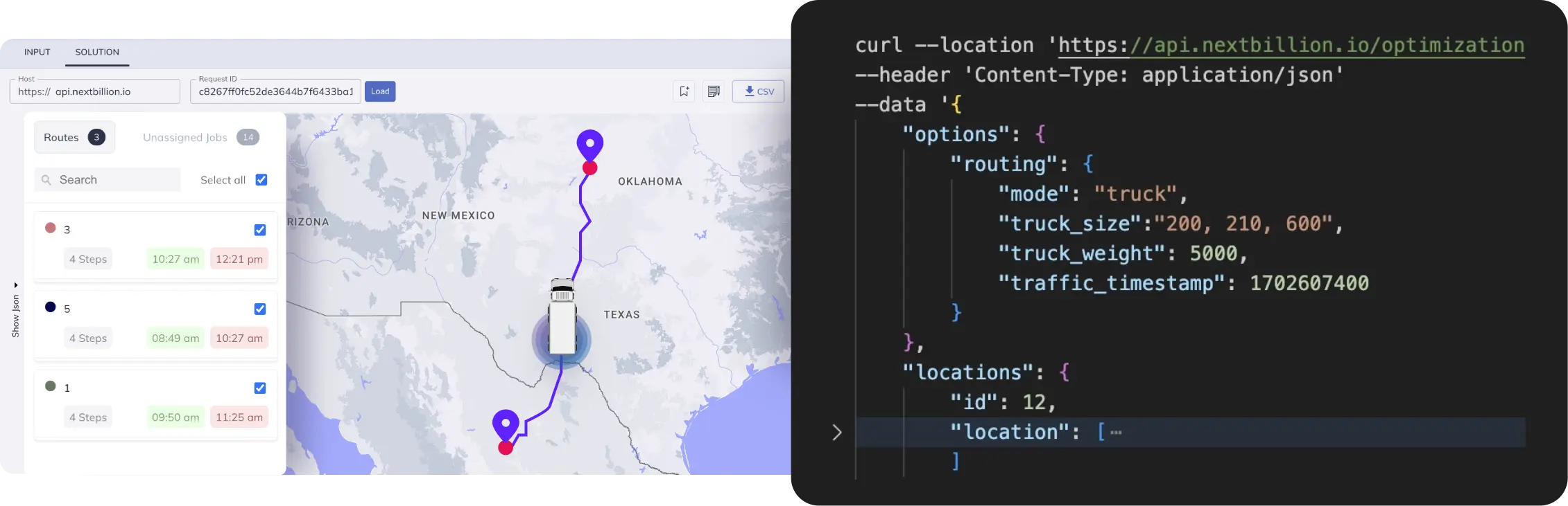
teuck routing
A. Truck Routing

Not all roads are suitable for trucks. Some have height or weight restrictions, while others ban hazardous materials. This feature ensures that every route is legally and logistically viable for your fleet.

Truck Dimensions – The system considers the height, width, weight, and axle load of each truck to prevent routing through restricted roads, low bridges, or weight-limited highways.

Cargo Type Compliance – If a vehicle is carrying hazardous materials, it won’t be sent through tunnels, populated areas, or roads where such cargo is restricted.

HOS (Hours of Service) Compliance – To prevent driver fatigue and ensure regulatory compliance, the system:
✅ Limits daily driving hours to stay within legal requirements.
✅ Schedules rest breaks at safe and convenient locations.
✅ Plans for overnight off-duty periods on multi-day routes.

Example: A chemical transport truck needs to avoid city centers and certain tunnels due to hazardous cargo restrictions. The system automatically excludes those routes and finds a compliant alternative.

B. Safe Routes

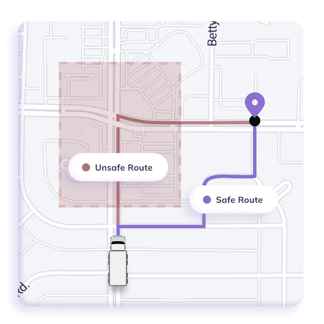
Driver safety is a top priority, especially in high-risk areas. This feature helps businesses proactively avoid danger zones and ensure safer operations.

  • Hazardous Zone Avoidance – Prevents routing through areas prone to accidents, extreme weather, or dangerous road conditions.

  • Custom Base Maps – Logistics managers can flag unsafe neighborhoods or high-theft areas, preventing trucks from passing through risky locations.

  • Safe Parking and Rest Stops – The system identifies secure locations for drivers to take breaks, ensuring compliance with HOS regulations and reducing the risk of roadside incidents.

💡 Example: A fleet manager marks a particular city block as a high-risk area for cargo theft. The system will automatically reroute deliveries to bypass that zone.

trucking benefits

C. Traffic-Aware Routes

Traffic congestion can cause delays, missed ETAs, and higher fuel consumption. This feature ensures that routes are optimized based on real-world conditions.

  • Real-Time Traffic Monitoring – The system analyzes live traffic conditions to avoid congested roads and suggest faster alternatives.

  • Historical Traffic Trends – It also considers past traffic patterns, so routes can be adjusted based on the time of day and day of the week.

  • Smart ETA Calculation – Instead of just relying on distance, the system predicts accurate arrival times based on expected road conditions.

Example: A courier company schedules deliveries for 5 PM, a known rush-hour period. The system proactively adjusts the route to avoid heavy traffic zones, keeping deliveries on time.

D. Intelligent Fleet Routing 

Fleet managers need flexibility in route planning. This feature ensures that routes are optimized based on business priorities, vehicle capabilities, and operational costs.

plan route in advance

Capacity Limits – Routes are optimized based on how much a vehicle can carry:

Weight & volume restrictions to prevent overloading.

Multi-vehicle distribution to maximize efficiency.

Pickup & Delivery Sequencing – Ensures that orders are grouped in the most logical and cost-effective order, preventing backtracking and unnecessary detours.

Task Distribution – Balances the workload across all available vehicles to prevent overuse of a few trucks while others remain idle.

Cost-Based Optimization – Helps businesses cut down on expenses by optimizing for:

Fuel efficiency – Avoids routes with excessive stops and idling.

Labor costs – Distributes work evenly among drivers.

Maintenance costs – Avoids overusing certain vehicles, extending their lifespan.

Custom Objectives – Businesses can choose what to prioritize when planning routes:

Minimize travel time – Ensure faster deliveries.

Minimize the number of vehicles used – Cut operational costs.

Evenly distribute tasks – Avoid overloading some drivers while others have less work.

Balance fuel and travel costs – Optimize expenses without compromising efficiency.

Example: A logistics company needs to deliver 500 packages using 20 vehicles. The system automatically distributes deliveries based on vehicle capacity, driver schedules, and fuel efficiency, ensuring lower costs and higher productivity.

How to Integrate Geotab with NextBillion.ai

Integrating NextBillion.ai’s Fleet Hub with Geotab Telematics helps fleet managers plan smarter routes, reduce costs, and improve efficiency. Follow these steps to get everything set up.

Before You Begin

Ensure you have:

  • A Geotab account with access to vehicle and address data.

  • A NextBillion.ai Cloud Console (NCC) account to manage integration and route planning.

Step 1: Setting Up the Connection

To begin integrating Geotab with Fleet Hub, follow these steps:
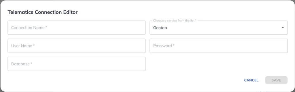
  1. Log in to NextBillion.ai Cloud Console (NCC).

  2. Navigate to ‘Fleet Hub’ > ‘Telematics Integration’ from the left-hand menu.

  3. Click ‘Add New Connection.’

telematics connection

  • When integrating Geotab with NextBillion.ai’s Fleet Hub, the Telematics Connection Editor requires the following parameters:

Connection Name 

This is a custom name assigned to the connection.

It helps identify the specific Geotab integration within Fleet Hub.

Choose a Service from the List

This dropdown allows users to select Geotab as the telematics provider.

It ensures the system connects to the correct telematics API.

User Name

This field requires the Geotab account username used to access the Geotab platform.

It is typically an email ID or unique username provided during Geotab account setup.

Password

This is the Geotab account password associated with the username.


It is required for authentication and secure access to Geotab’s telematics data.

Database

Geotab uses a multi-tenant database structure where each company has its own database name.

This field requires the database name assigned to the user’s Geotab account.

It ensures the integration connects to the correct dataset for vehicle tracking, routing, and dispatching.

These credentials authenticate the connection between Geotab and Fleet Hub, enabling seamless data transfer.

Once configured, Fleet Hub can fetch vehicle locations, driver activity, and other telematics data for route optimization and dispatching.

  • Click ‘Save’ to confirm the integration.

Your Geotab account is now linked to NextBillion.ai’s Fleet Hub!

Step 2: Import Address Data from Geotab

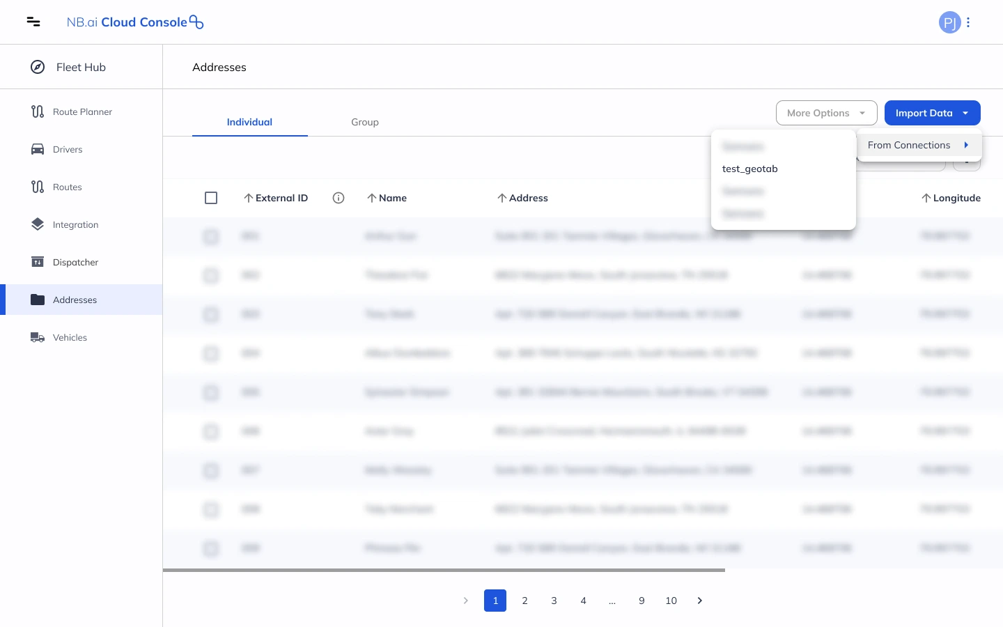
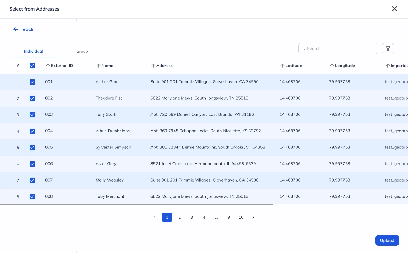
Once the integration is set up, you can import address data:

  1. Click ‘Addresses’ from the left toolbar.

  2. On the Addresses screen, click ‘Import Data’ > ‘From Connections.’

  3. Select ‘Geotab Telematics’ from the list of available connections.

  4. Choose to import individual addresses or use the Group tab to import multiple addresses.

  5. The system will automatically fetch address data from your Geotab account.

import adress from geotab-1

Step 3: Import Vehicle Data from Geotab

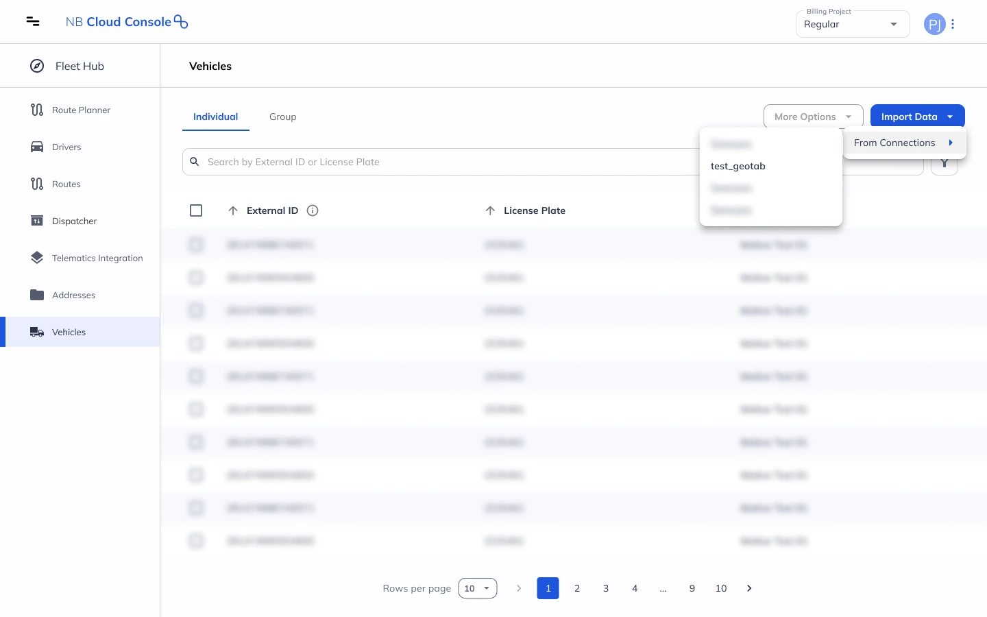
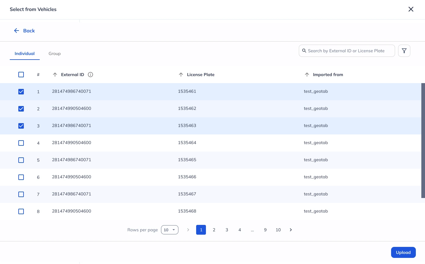
Follow similar steps to import vehicle data:

  1. Click ‘Vehicles’ from the left toolbar.

  2. On the Vehicles screen, click ‘Import Data’ > ‘From Connections.’

  3. Select ‘Geotab Telematics’ from the available connections.

  4. Choose to import individual vehicles or use the Group tab to import multiple vehicle records.

  5. The system will retrieve vehicle data from your Geotab account.

import vehicles data from geotab

Step 4: Use Route Planner to Optimize Routes

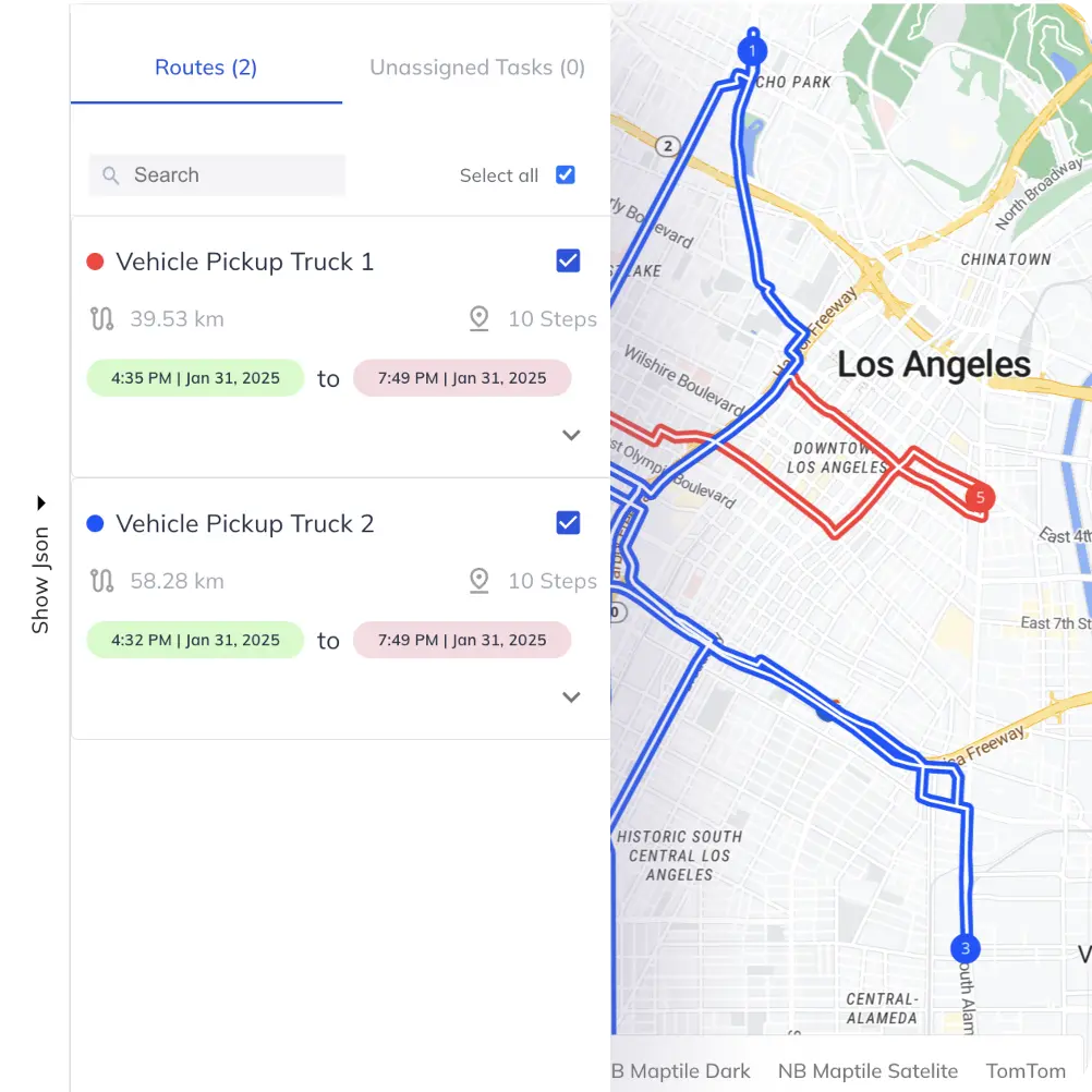
With address and vehicle data imported, you can generate optimized routes:

  1. Open the ‘Route Planner’ app from the left toolbar.

  2. Click ‘Start’ on the input screen.

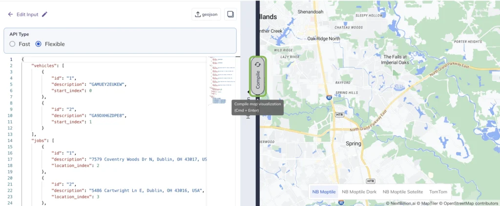
A window will appear where you can configure your input data. The screen is divided into the following tabs:
configure screen in geotab

Configure Tab

  • Select API type: Fast or Flexible.

  • Choose Geotab Telematics from the ‘Select Connection’ dropdown.

  • Click ‘Next’ to proceed.

Jobs Tab

  • Use ‘Select Addresses’ to fetch Geotab address data.

  • Choose the addresses you want to include and click ‘Upload.’

  • Map VRP attributes to match uploaded data fields, then click ‘Next.’

Shipments and Depots Tab

  • Upload shipments and depot data as needed or click ‘Skip’ if not required.

Vehicles Tab

  • Use ‘Select Vehicles’ to fetch Geotab vehicle data.

  • Select the relevant vehicles and click ‘Upload.’

  • Map VRP attributes and click ‘Next.’

select geotab vehicles

Options Tab


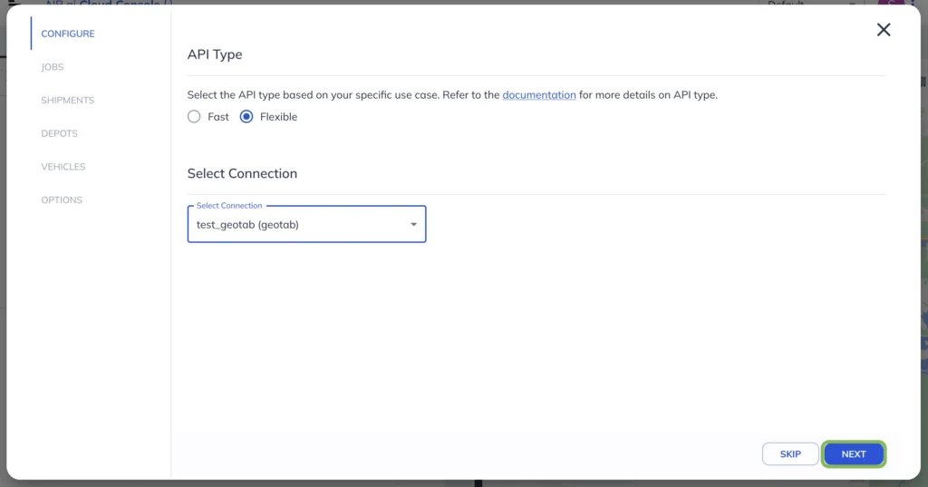
Configure additional parameters:

  • Constraints: Max vehicle overtime, max lateness, max waiting time.

  • Objective: Minimize travel cost (distance/duration) or set custom optimization goals.

  • Routing Mode: Select Car or Truck and specify a Traffic Timestamp.

options setup for geotab

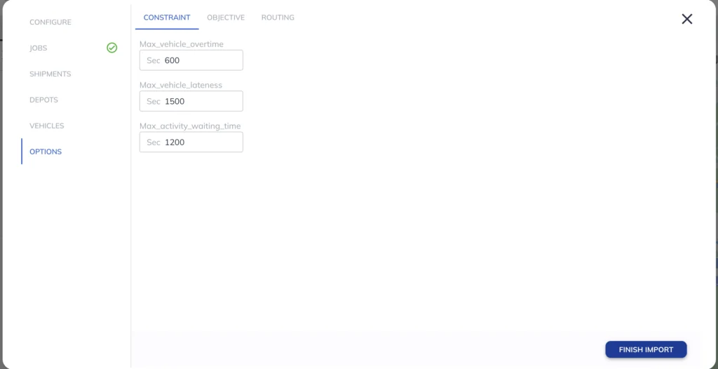
Click
‘Finish Import’ to complete the setup.

Step 5: Generate and Dispatch Optimized Routes
compile geotab input

  1. After finalizing the setup, click ‘Compile’ to visualize routes on the map.

  2. Click ‘Run’ to execute the route planner and generate optimized routes.

  3. To dispatch routes to Geotab:

    • Click ‘Share’ and select ‘Dispatch to Connection.’

    • Choose the Geotab Telematics connection from Fleet Hub.

dispatch routes to geotab

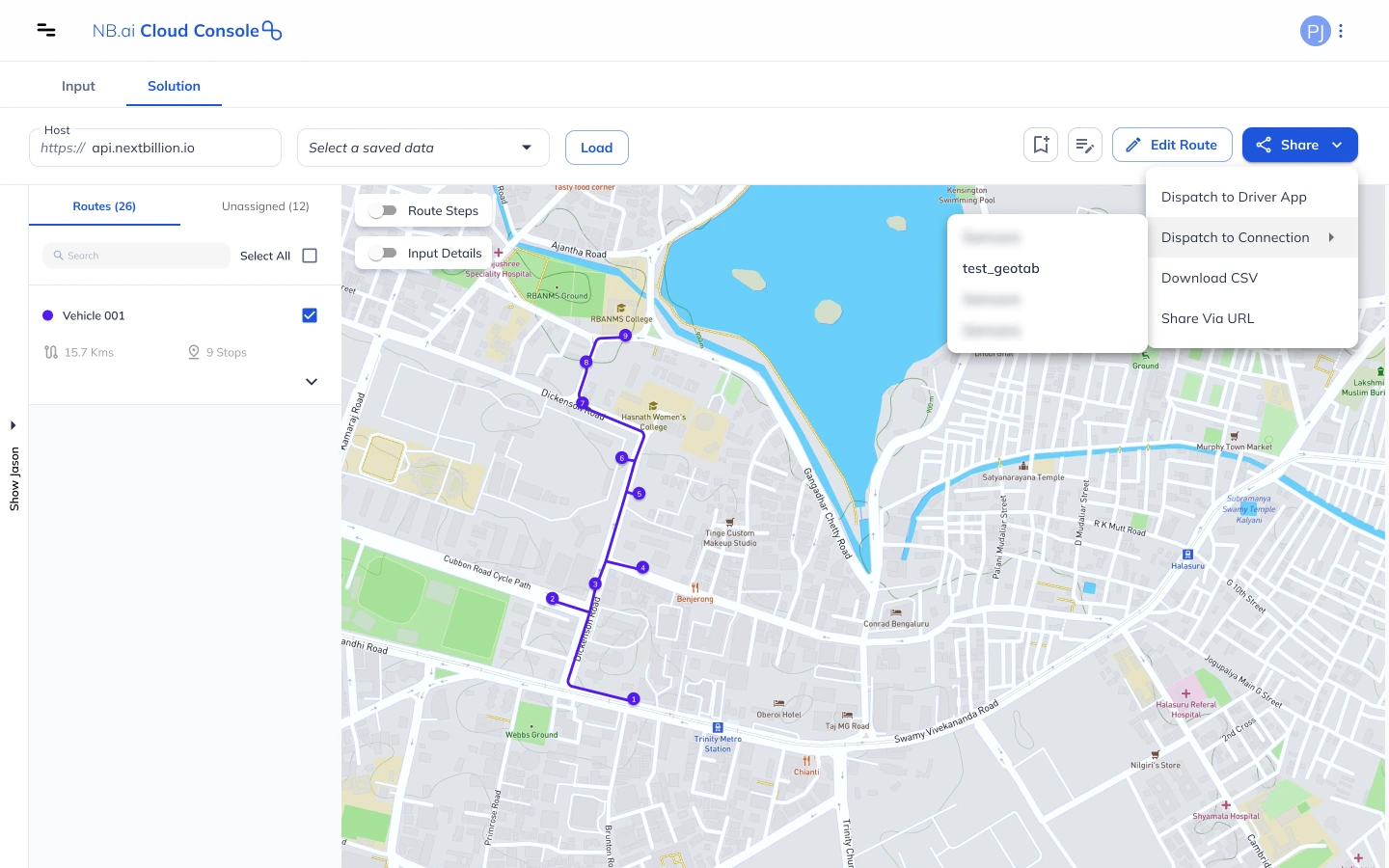
Once dispatched, drivers will receive their optimized routes directly in Geotab, ensuring faster deliveries and reduced operational costs.
Disptach route to Geotab
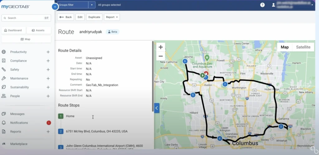
Refer to Dispatch Optimized Routes to Geotab documentation for more details.

How This Integration Optimizes Delivery Routes

Integrating Geotab with NextBillion.ai’s Fleet Hub enhances fleet efficiency by:

  • Automating Data Synchronization: Reduces manual work and eliminates errors in importing fleet data.

  • Improving Route Optimization: Creates efficient delivery routes, reducing fuel consumption and travel time.

  • Enhancing Fleet Visibility: Enables real-time tracking and proactive decision-making.

  • Seamless Dispatching: Allows direct dispatch of optimized routes to Geotab, ensuring accurate execution.

  • Cost Reduction: Helps optimize fleet operations, cutting down operational costs while improving delivery speed.

By leveraging this integration, logistics companies can improve last-mile efficiency, increase vehicle utilization, and provide better customer service.

Benefits of Using Geotab with NextBillion.ai for Delivery Fleets

Integrating Geotab with NextBillion.ai helps fleets run smarter, faster, and more cost-effectively. Here’s how:


  • Reduced fuel consumption – Minimize unnecessary mileage and idle time.


  • Improved route accuracy – AI-driven optimizations for real-world conditions.


  • Lower vehicle wear & tear – Smarter routes reduce maintenance costs.


  • Better driver productivity – Compliance-friendly scheduling reduces fatigue.


  • Scalability for large fleets – Efficiently handle multi-vehicle, multi-stop logistics.

How to Get Started?

Getting started with Geotab and NextBillion.ai is simple. Follow these steps to integrate smarter route optimization into your fleet operations:

Explore the Integration on the Geotab Marketplace

Visit the Geotab Marketplace to learn more about the NextBillion.ai Route Optimization API and how it enhances Geotab’s capabilities.

Request a Demo from NextBillion.ai

See the integration in action with a hands-on demo. Understand how real-time optimization, custom routing constraints, and AI-powered planning can benefit your fleet.

Start Optimizing Your Fleet

Once you’re ready, set up the API integration, connect your Geotab telematics data, and begin optimizing routes for lower costs, better efficiency, and improved delivery performance.

Ready to take your fleet to the next level? Get started today!

Conclusion

Integrating Geotab with NextBillion.ai takes route planning to the next level. By combining real-time telematics with AI-driven optimization, businesses can cut costs, boost efficiency, and improve driver safety. Whether managing a small fleet or a large logistics operation, this integration helps you plan smarter routes, reduce fuel consumption, and keep deliveries on track.

About Author

Shivangi Singh

Shivangi is a seasoned Technical Writer with a passion for simplifying technical concepts. With over 5 years of experience, she specializes in crafting clear and concise documentation for various technical products and platforms.

Ready to get started?

Table of Contents