


The Problem
A ride-hailing company with airport-centric operations approached us for a custom mapping solution. With an intra-city fleet of a few thousand cabs, they had previously been using a plug and play maps API (you-know-which) as their geospatial solution but soon realized that it posed several challenges.
These challenges gave rise to different concerns for the two key stakeholders:
- The Business: Their key concern was the inaccuracy in estimating the fare prior to the trip. The mapping solution played a vital role here because the company’s USP lay in charging the fare based solely on the distance traveled, without accounting for time constraints which are typically used to calculate surge pricing. Inaccurate routing led to inaccurate fare estimation which in turn caused revenue losses & client disputes.

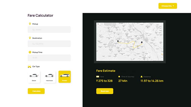
A glance at the company’s pre-trip fare calculator
Secondly, their API costs were now much higher — almost a 10X price bump by the map provider. For a low-margin high-volume business like theirs, this was a huge challenge.
2. The Development Team: Their concerns were centered around finding a solution that would serve as a 1:1 replacement for their current API and require minimum integration effort. They also sought active support from their solution provider at every stage of the process to minimize the time to market.
Our approach
We started by looking into the existing data and found that the problems ran much deeper:
- The recommended routes were far from optimal as they didn’t account for the driver behavior and actual driving patterns. This is because drivers tend to amend the recommended routes based on their personal preferences and knowledge of the local area.
- There was an inability to update local serviceability conditions in real-time without the map provider’s decision — which meant avoidable problems such as road closures and other incidents couldn’t be sidestepped by the team itself.
- There were severe inaccuracies in the predicted trip duration which became even more glaring when one compared the initial ETA with the actual trip duration — unlike consumer maps, the client needed extremely accurate ETAs before the trip started.
Our Solution
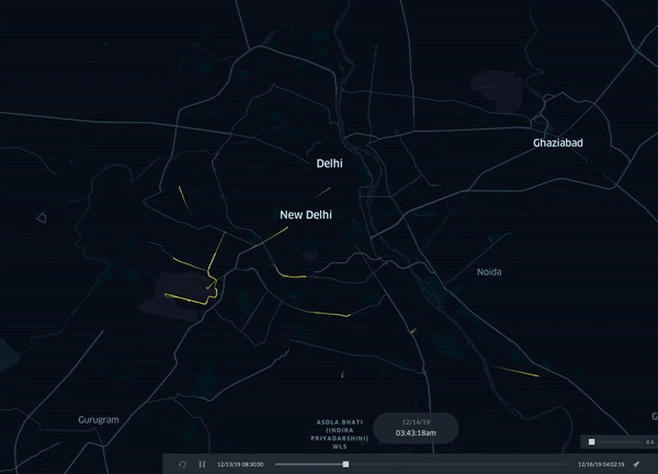
Visualization of the historical trip data
To solve this multi-faceted problem, we first ran a demo in one city.
As custom map experts, we knew that leveraging the organization’s historical data is what would give us the insights to solve its unique challenges. So we began by mining their data to create a map that detailed every single trip taken by their drivers over a period of 3 months.
This helped us identify patterns in the driver behavior which we leveraged further to make more accurate route and ETA predictions with the help of AI. It also allowed us to identify the blind spots in their existing geospatial solution’s map and incorporate them into our new hyper-local map stack using a custom layer.
We also created a DIY tool that allows the team to make changes as per hyperlocal nuances like serviceability conditions in real-time. After all, one map doesn’t fit all!
Finally, we ensured that our API closely replicated the development principles of their existing solution so that the integration would be faster, seamless, and more cost-effective. We also offered them flexible commercial plans by passing on our cost savings to them to overcome the challenge of high API costs.
The Outcome
With our custom mapping solution, the organization succeeded in:
- Increasing fare accuracy by 12%
- Reducing operating costs by 60%
- Improving their ETA accuracy by 8%
The 1:1 replaceability with their existing APIs also ensured a speedy go-to-market. On seeing this ROI, the client’s leadership and tech team decided to continue with NextBillion.ai and expand our engagement for their pan-state operations!
If you’re interested in implementing better control, customization, and profitability for your ride-hailing business, reach out to us now!
Ready to get started?
Request a DemoSubscribe to our Newsletters
Get the best practices for route planning & optimization, delivered to your inbox.
Subscribe