


Join the growing list of companies that trust us
Value We Bring to You

Cloud-Agnostic
API

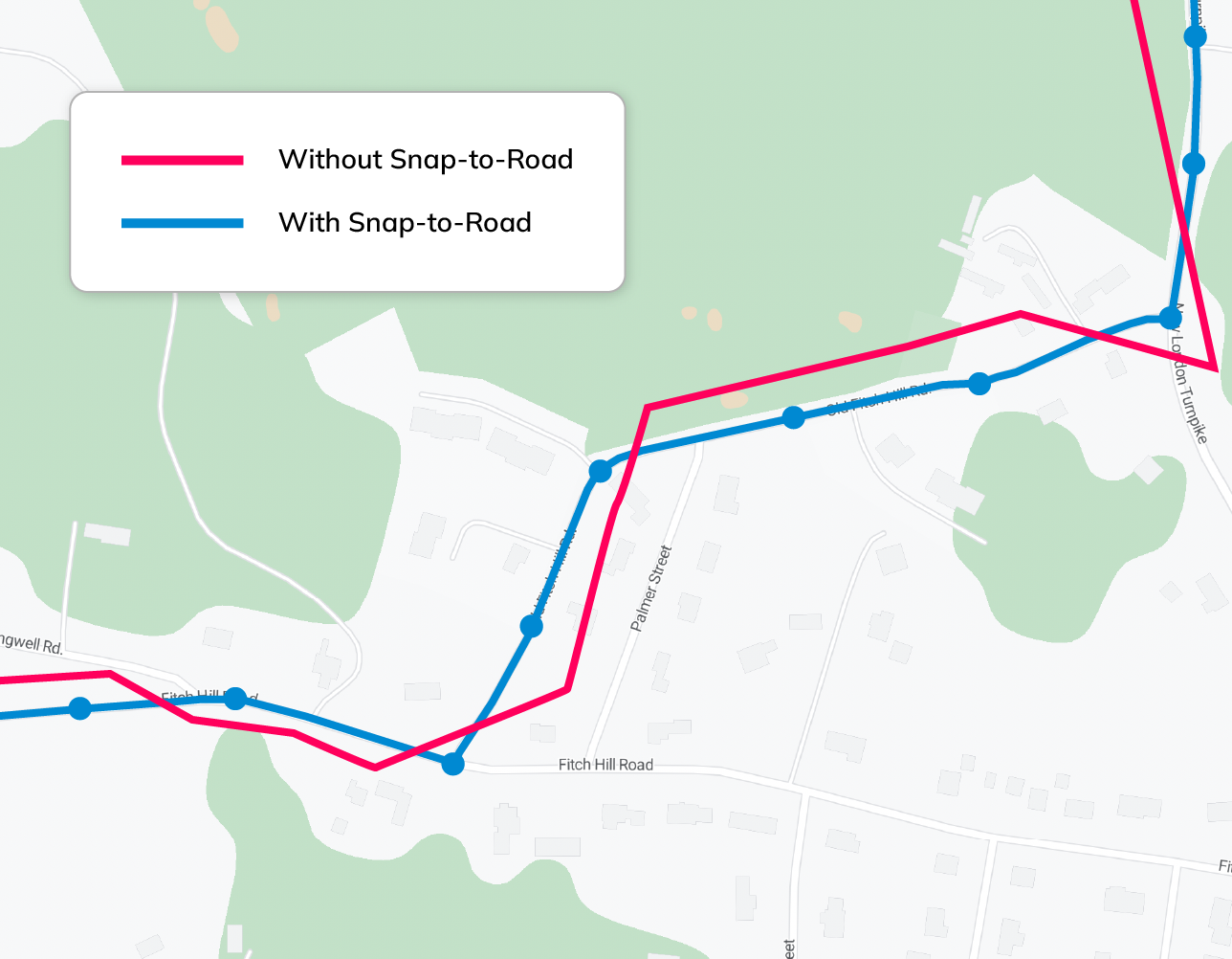
Accurate Route Reconstruction

High-Precision Matching

Dedicated
Support
Analyze Routes Taken and Fix Missing GPS Data
NextBillion.ai’s Snap-to-Road API solves for a variety of use cases, be it for track-and-trace domains or for on-demand route optimization scenarios. Get the data you need, tailored to your use case.
Compute, analyze and optimize with relevant data
Track and trace routes taken and retrieve a complete set of attributes — speed limits, vehicle speed, overlapping routes, etc. — that aids your use case.
Solve for multi-stop routes with up to 200 coordinates per request.
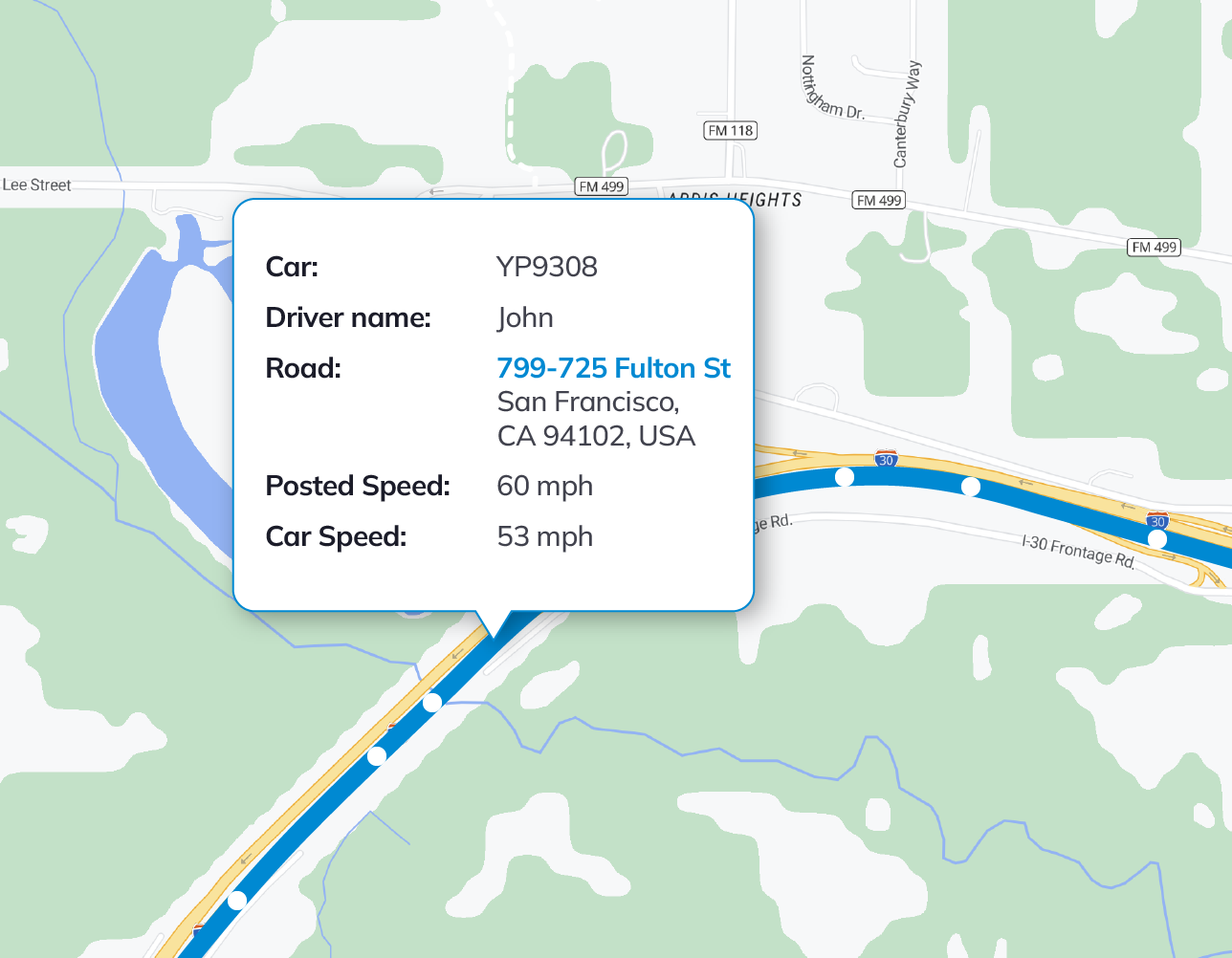
Get speed limit, driver profile information and more
Retrieve vehicle speed data and compare it against legal speed limits for the routes taken to evaluate driver safety, compliance, performance, etc. Enhance trip analyses by accounting for factors like rest stops, toll payments and transit time, and harness this information for fleet and logistics management.
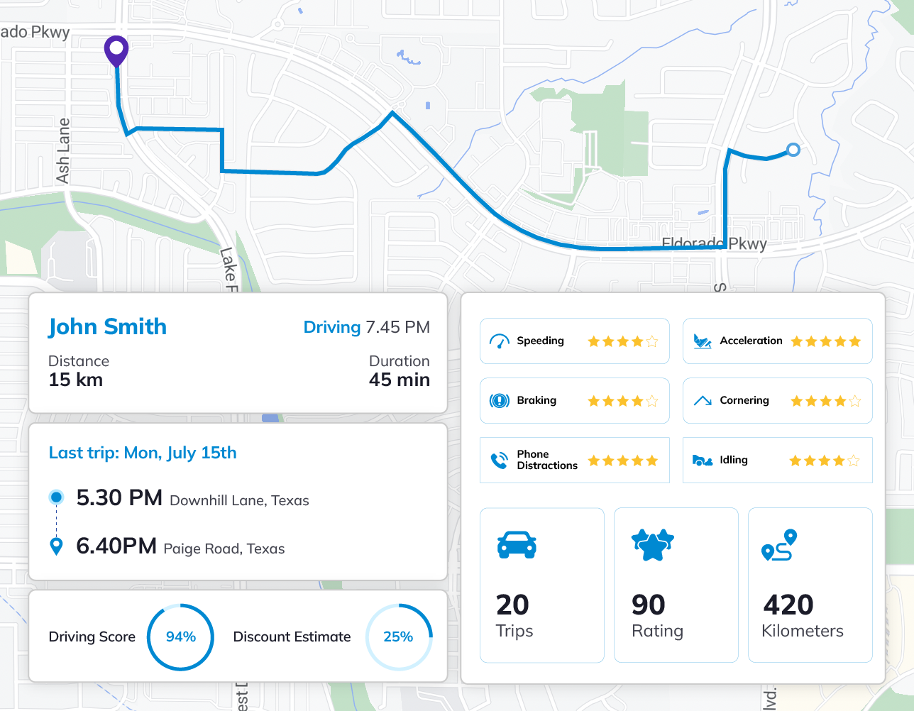
Achieve increased transparency for insurance use cases
Identify deviators, defaulters and unsafe drivers by analyzing driver behavior — speed profiles, illegal maneuvers, vehicle restrictions and more.
Get detailed telematics and optimize your insurance products according to the in-depth behavioral data obtained.
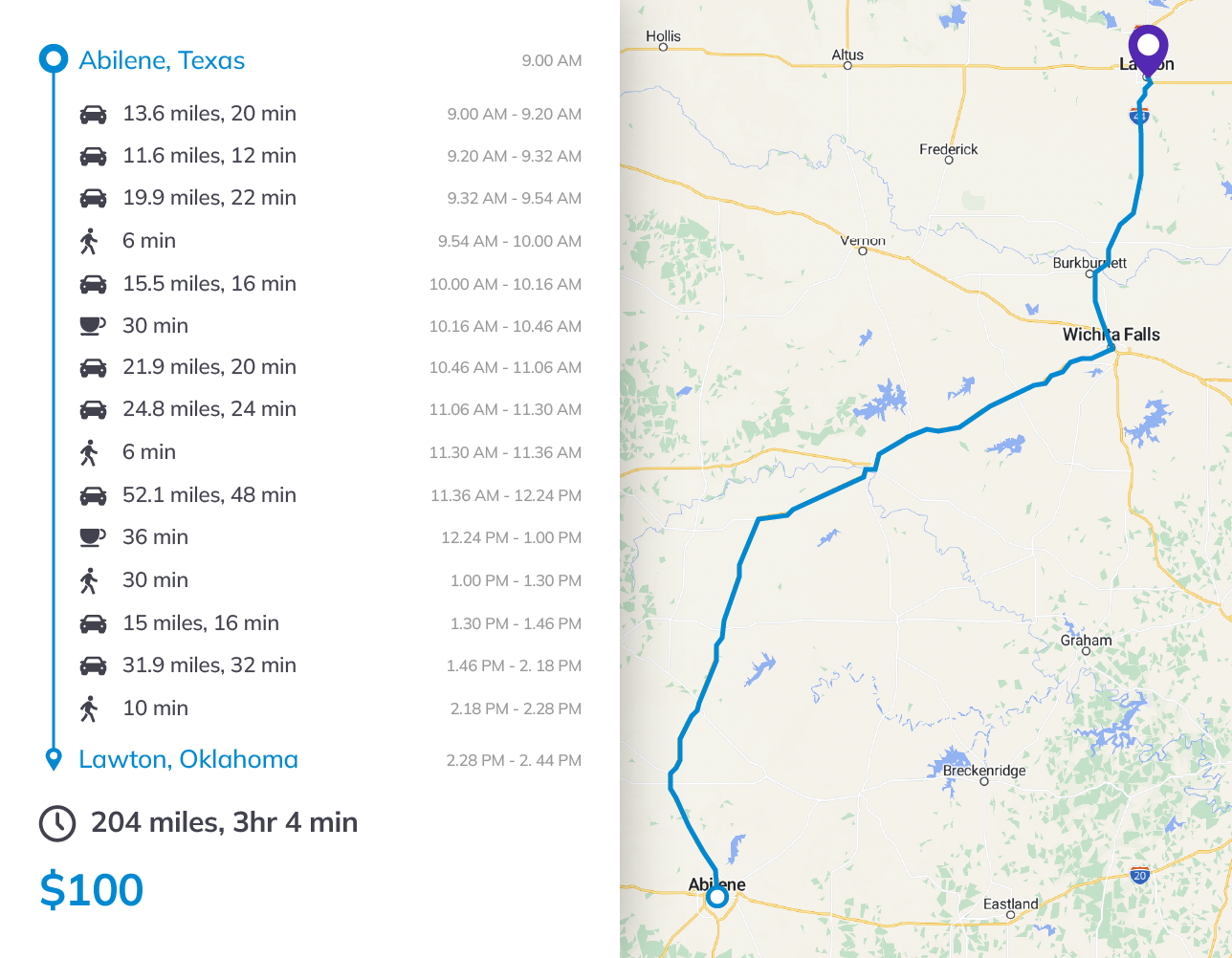
Visualize the complete user journey
Whether for field service or gig workers, track the distance your workforce covers on foot and in various vehicle types to automate payments accordingly.
Retrieve accurate information for mileage tracking and tax reimbursements.
Get the Best Value for any Volume of API calls
Save up to 80% with NextBillion.ai’s Snap-to-Road API
| Monthly requests | Google Maps | |
| Up to 100,000 | $1.80 | $10.00 |
| 100,001 – 500,000 | $1.50 | $8.00 |
| 500,001 – 1,000,000 | $1.20 | - |
| 1,000,001 – 5,000,000 | $0.90 | - |
| 5,000,000+ | Contact sales | - |
Volume-based pricing: Cost per thousand requests | By monthly usage volume | Prices shown in USD
Industries That Benefit From NextBillion.ai’s Snap-to-Road API
We cater to your unique needs and use cases
More accurate locations | Increased data transparency | Improved operational efficiency
Asset Tracking

Fleet Management

Insurance Telematics

Field Service Management
Mileage Tracking

OOH Advertising
Designed for Developers
Easy to switch | Get up and running in just a few minutes
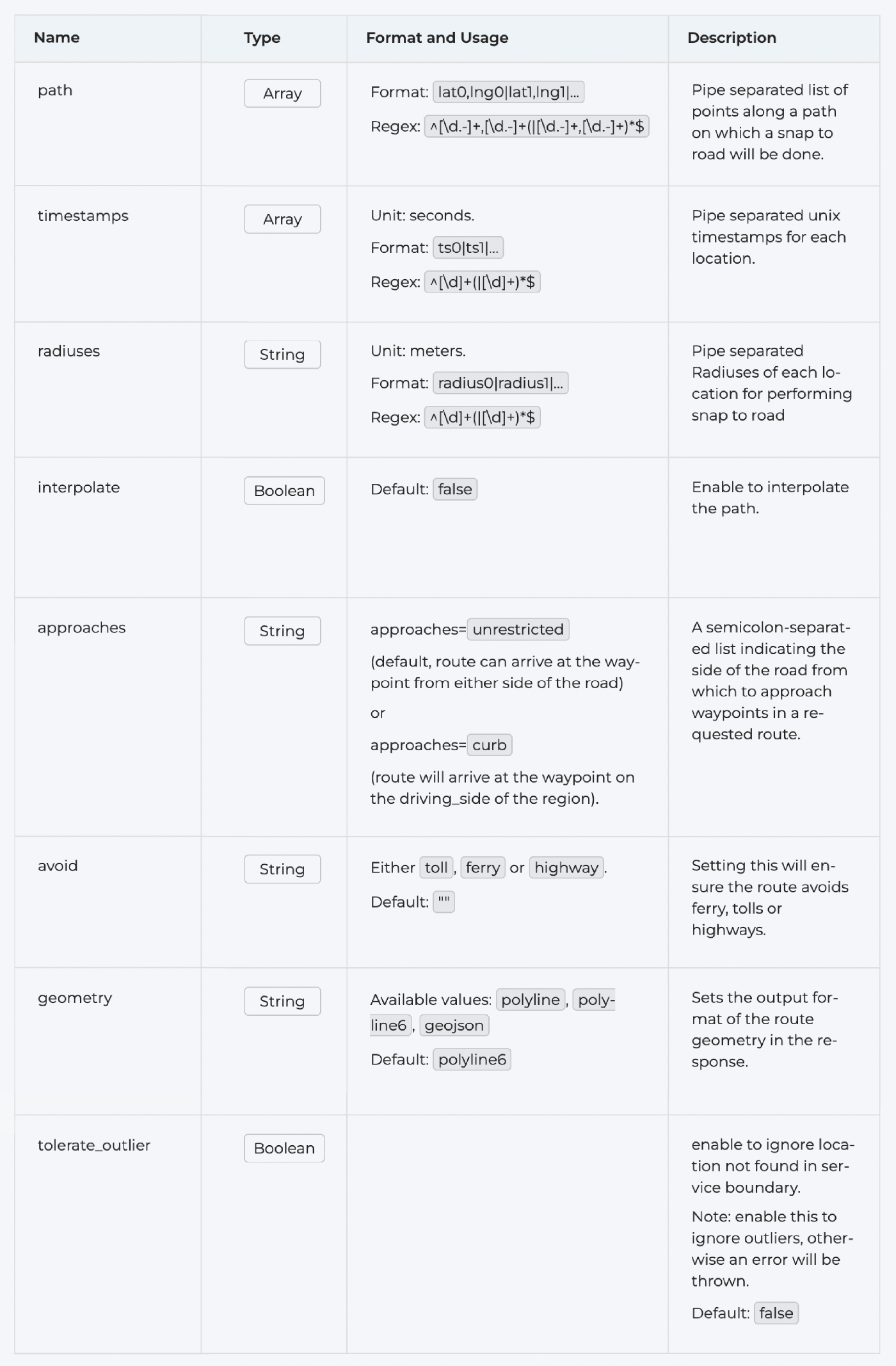
API Query Parameters
Sample API Request
https://api.nextbillion.io/snapToRoads/json?key={{api_key}}&path=41.375371501680604,2.1358108520507812|41.3753352 7276556,2.1364009380340576|41.375246713110485,2.1372538805007935|41.37543188316085,2.137919068336487|41. 37525878943418,2.138814926147461|41.375343323637296,2.1397966146469116|41.37491260059898,2.140027284622 1924|41.xxxxxxxxxxxxxxx,2.1400755643844604&interpolate=true×tamps={{cur-time}}|{{cur-time2}}|{{cur-time3}}|{{cu r-time4}}|{{cur-time5}}|{{cur-time6}}|{{cur-time7}}|{{cur-time8}}&radiuses=25|25|25|25|25|25|25|25
Sample API Response
{
  "status": "Ok",
  "snappedPoints": [
    {
      "location": {
        "latitude": 37.786766,
        "longitude": -122.412333
      },
      "originalIndex": 0,
      "distance": 4,
      "name": "Shannon St",
      "bearing": 0
    },
    {
      "location": {
        "latitude": 37.786766,
        "longitude": -122.412333
      },
      "originalIndex": 1,
      "distance": 4,
      "name": "Shannon St",
      "bearing": 0
    },
    {
      "location": {
        "latitude": 37.786766,
        "longitude": -122.412333
      },
      "originalIndex": 4,
      "distance": 4,
      "name": "Shannon St",
      "bearing": 0
    },
    {
      "location": {
        "latitude": 37.786766,
        "longitude": -122.412333
      },
      "originalIndex": 5,
      "distance": 4,
      "name": "Shannon St",
      "bearing": 0
    },
    {
      "location": {
        "latitude": 37.786766,
        "longitude": -122.412333
      },
      "originalIndex": 6,
      "distance": 4,
      "name": "Shannon St",
      "bearing": 0
    },
    {
      "location": {
        "latitude": 37.786766,
        "longitude": -122.412333
      },
      "originalIndex": 7,
      "distance": 4,
      "name": "Shannon St",
      "bearing": 0
    }
  ],
  "distance": 0,
  "geometry": ["ifseF`tcjV??????????"]
}
Our Customers Love Us

“Highly customized and efficient mapping solutions for our business needs.”
NextBillion.ai offers mapping expertise that can be quickly customized to suit different needs. They were able to swiftly integrate with our proprietary data set and provide us with an integrated solutions”
★★★★★
Awards and Honors
The quality and impact of our solutions are exemplified by the user awards we’ve won.

As Seen On
