


Join the growing list of companies that trust us
Value We Bring to You
Cloud-agnostic
API
Efficient scaling with zero latency
Custom geocoding abilities
Dedicated
support
Provide Your Customers with an Accurate and
Enhanced Search Experience.
Be it for small or large datasets, our geocoding and search API returns the desired output with a quicker response time.
Convert Locations into Geo Coordinates
Use our API’s forward geocoding feature to convert structured addresses into lat-long coordinates. Convert individual addresses or even a sequence of them from your dataset with accuracy and precision.
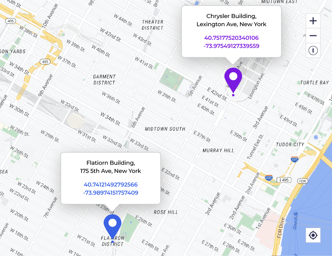
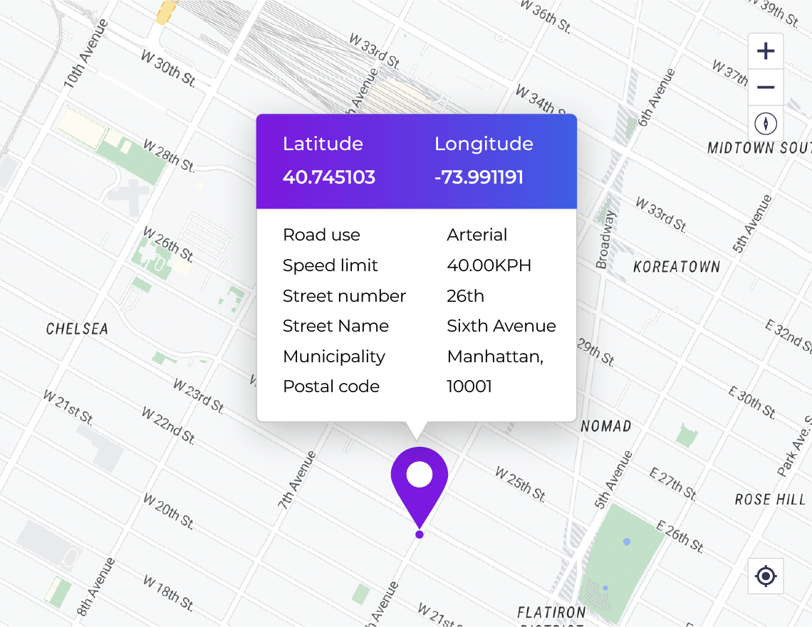
Retrieve Contextual Information from Location Data
Convert GPS coordinates into addresses, points of interest or other geographical references. Get relevant and complete information for a given set of coordinates with our reverse geocoding feature.
Match User Intent with Search and Auto-complete
Eliminate friction by suggesting the most relevant destination addresses within just a few user keystrokes. Help users quickly identify their desired destinations and guide them there with ease.
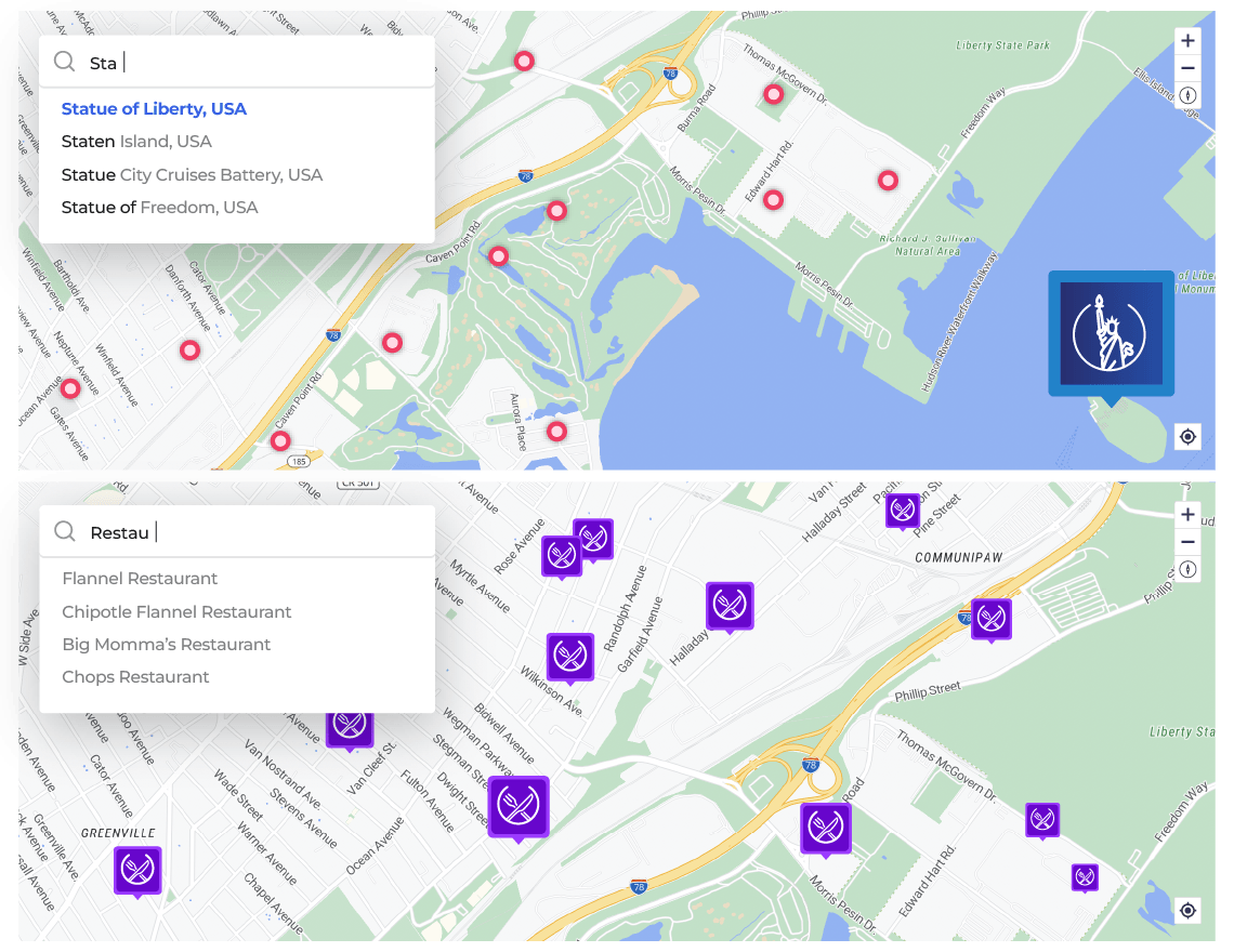
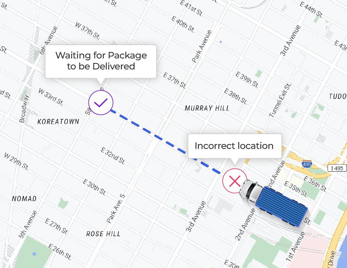
Tailored to your Use-case
Mark POIs based on your user-generated data and reference them as per your requirements. Plot POIs, pick-up and drop-off points with precision and ensure that your deliveries are handled with accuracy.
Unbeatable Pricing
Get the best value for any volume of API calls that you may need
Volume-based pricing: Cost per thousand requests | By monthly usage volume | Prices shown in USD
Focus Categories
We cater to the unique requirements of each business and use case.
Achieve operational efficiency | Improve unit economics | Increase gross margins
Fleet Tracking

Data Enrichment

Internet of Things
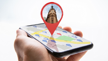
Image Processing

Classifieds

Payment Processing
Designed for Developers
Easy to use and integrate | Get up and running within a few minutes
API Query Parameters
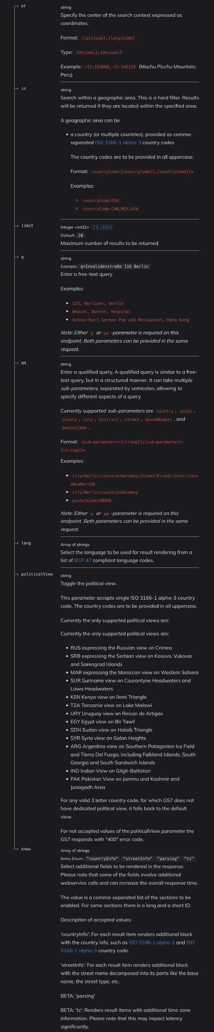
GET /h/geocode
{
  "items": [
    {
      "title": "string",
      "id": "string",
      "politicalView": "string",
      "resultType": "administrativeArea",
      "houseNumberType": "PA",
      "addressBlockType": "block",
      "localityType": "postalCode",
      "administrativeAreaType": "county",
      "address": {
        "label": "string",
        "countryCode": "string",
        "countryName": "string",
        "stateCode": "string",
        "state": "string",
        "countyCode": "string",
        "county": "string",
        "city": "string",
        "district": "string",
        "subdistrict": "string",
        "street": "string",
        "block": "string",
        "subblock": "string",
        "postalCode": "string",
        "houseNumber": "string",
        "building": "string"
      },
      "position": {
        "lat": 0,
        "lng": 0
      },
      "access": [
        {
          "lat": 0,
          "lng": 0
        }
      ],
      "distance": 172039,
      "mapView": {
        "west": 0,
        "south": 0,
        "east": 0,
        "north": 0
      },
      "categories": [
        {
          "id": "string",
          "name": "string",
          "primary": true
        }
      ],
      "foodTypes": [
        {
          "id": "string",
          "name": "string",
          "primary": true
        }
      ],
      "houseNumberFallback": true,
      "timeZone": {
        "name": "string",
        "utcOffset": "string"
      },
      "scoring": {
        "queryScore": 0,
        "fieldScore": {
          "country": 0,
          "countryCode": 0,
          "state": 0,
          "stateCode": 0,
          "county": 0,
          "countyCode": 0,
          "city": 0,
          "district": 0,
          "subdistrict": 0,
          "streets": [
            0
          ],
          "block": 0,
          "subblock": 0,
          "houseNumber": 0,
          "postalCode": 0,
          "building": 0,
          "unit": 0,
          "placeName": 0,
          "ontologyName": 0
        }
      },
      "parsing": {
        "placeName": [
          {
            "start": 0,
            "end": 0,
            "value": "string",
            "qq": "country"
          }
        ],
        "country": [
          {
            "start": 0,
            "end": 0,
            "value": "string",
            "qq": "country"
          }
        ],
        "state": [
          {
            "start": 0,
            "end": 0,
            "value": "string",
            "qq": "country"
          }
        ],
        "county": [
          {
            "start": 0,
            "end": 0,
            "value": "string",
            "qq": "country"
          }
        ],
        "city": [
          {
            "start": 0,
            "end": 0,
            "value": "string",
            "qq": "country"
          }
        ],
        "district": [
          {
            "start": 0,
            "end": 0,
            "value": "string",
            "qq": "country"
          }
        ],
        "subdistrict": [
          {
            "start": 0,
            "end": 0,
            "value": "string",
            "qq": "country"
          }
        ],
        "street": [
          {
            "start": 0,
            "end": 0,
            "value": "string",
            "qq": "country"
          }
        ],
        "block": [
          {
            "start": 0,
            "end": 0,
            "value": "string",
            "qq": "country"
          }
        ],
        "subblock": [
          {
            "start": 0,
            "end": 0,
            "value": "string",
            "qq": "country"
          }
        ],
        "houseNumber": [
          {
            "start": 0,
            "end": 0,
            "value": "string",
            "qq": "country"
          }
        ],
        "postalCode": [
          {
            "start": 0,
            "end": 0,
            "value": "string",
            "qq": "country"
          }
        ],
        "building": [
          {
            "start": 0,
            "end": 0,
            "value": "string",
            "qq": "country"
          }
        ],
        "secondaryUnits": [
          {
            "start": 0,
            "end": 0,
            "value": "string",
            "qq": "country"
          }
        ],
        "ontologyName": [
          {
            "start": 0,
            "end": 0,
            "value": "string",
            "qq": "country"
          }
        ]
      },
      "streetInfo": [
        {
          "baseName": "string",
          "streetType": "string",
          "streetTypePrecedes": true,
          "streetTypeAttached": true,
          "prefix": "string",
          "suffix": "string",
          "direction": "string",
          "language": "string"
        }
      ],
      "countryInfo": {
        "alpha2": "string",
        "alpha3": "string"
      }
    }
  ]
}
Our Customers Love Us

“Highly customized and efficient mapping solutions for our business needs.”
NextBillion.ai offers mapping expertise that can be quickly customized to suit different needs. They were able to swiftly integrate with our proprietary data set and provide us with an integrated solutions”
★★★★★
Awards and Honors
The quality and impact of our solutions are exemplified by the user awards we’ve won.

As Seen On
